Time flies, it's already August 22nd. Do something special to remember this next day! Seriously, don't just think about it for a moment......do it today.
Many of the National Weather Service maps used here are not updated today, so this will mean an abbreviated report.
Next rain event has started in Kansas. Forecast for the next 2 days, and total 7 days below.
Day 1 below:
http://www.wpc.ncep.noaa.gov/qpf/fill_94qwbg.gif?1526306199054

Day 2 below:
http://www.wpc.ncep.noaa.gov/qpf/fill_98qwbg.gif?1528293750112

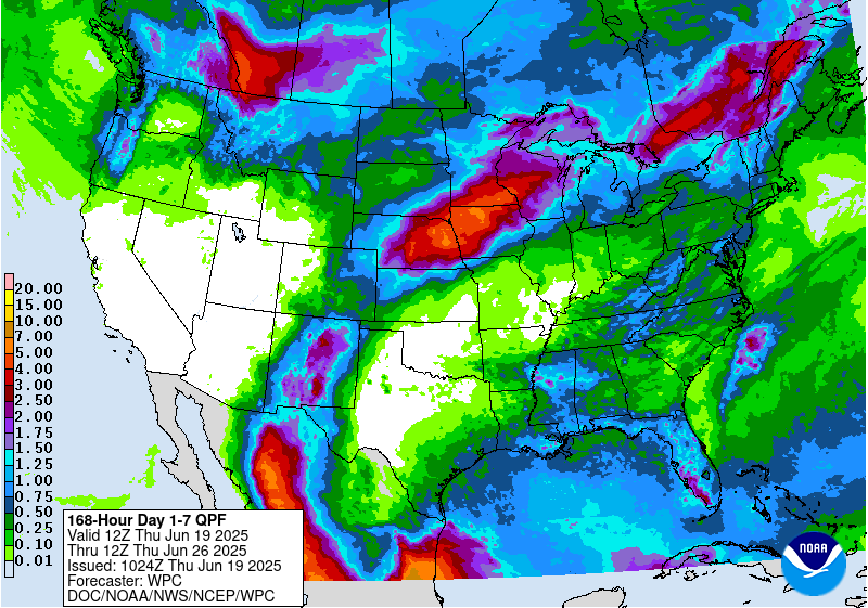
7 Day Total precipitation below:
http://www.wpc.ncep.noaa.govcdx /qpf/p168i.gif?1530796126

Severe Storm Risk. Hit the map for full screen. Elevated risk moves into the Plains on Thursday, then Midwest on Friday.
https://www.spc.noaa.gov/products/outlook/
Current Day 1 Outlook | |
Current Day 2 Outlook | |
Current Day 3 Outlook | |
Current Day 4-8 Outlook |
High Temperatures today and Thusday. Hottest in the West again. Cool in the Plains/Midwest then East.


Dew points. 70+ on this scale makes it feel uncomfortable(sticky air)! Humid air has been shunted to the Deep South and East Coast.
Very dry air diving south making it comfortable in the Plains/Midwest today........moving east.

Heat and high humidity COMBINED. Feels like temperature. Feeling sultry in deep south and southeast.

Here is the latest radar image. New rains emerging in the S.Plains.
http://www.nws.noaa.gov/radar_tab.php

Satellite picture.

Rains the past 24 hours.
Out with the old(rains in the East). In with the new(rains in the Plains)
![]()
You can go to this link to see rain totals from recent time periods:
https://water.weather.gov/precip/
Go to precipitation, then scroll down to pick a time frame. Hit states to get the borders to see locations better. Under products, you can hit "observed" or "Percent of normal"
Missouri to S.Plains was in horrible shape......the map below shows massive improvement in the S.Plains into Arkansas. Still a dry pocket in MO.
Wet from NE/w.IA/sw.MN.
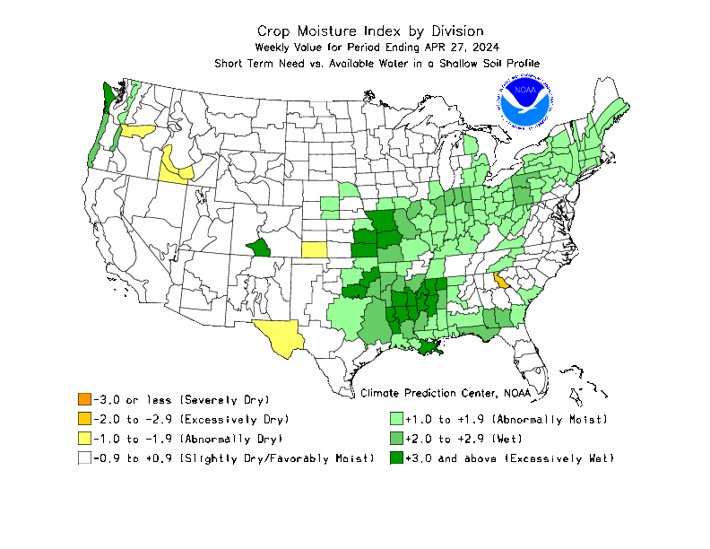
The 2nd map finally updated.
This is a shorter term soil moisture product vs the drought monitor which is cumulative over many months.


Below are rains compared to average of the last 7, 14, 30 and 60 days. Usually not updated for previous day until late the next day.
A great deal of rain in much of the Midwest to Southern Plains!
https://www.atmos.illinois.edu/~snodgrss/Ag_Wx.html


Drought Monitor. This product is updated every Thursday. Drought has been shrinking.........this measure takes into account the long term precip/sub soil moisture and goes back over MANY months.
http://droughtmonitor.unl.edu/Maps/CompareTwoWeeks.aspx

Question now seems to be how long will the very impressive Heat ridge in the East last?
Overnight models have suddenly diverged greatly. GFS and European models have huge cooling in week 2 while the Canadian model keeps the upper level ridge in place. Below is the Canadian model ensembles toward the end of week 2.
The top map is the ensemble average, the maps below are the individual members that make up the average.
++++++++++++++++++++++++++++++++++++++++++++++++++++++++++++++++
Each member is like the parent, Canadian model operational model.......with a slight tweek/variation in parameters. Since we know the equations to represent the physics of the atmosphere in the models are not perfect, its useful to vary some of the equations that are uncertain(can make a difference) to see if it effects the outcome and how.
The average of all these variations(ensembles) often yields a better tool for forecasting. It's always more consistent. The individual operational model, like each individual ensemble member can vary greatly from run to run.........and represent an extreme end of the spectrum at times. The ensemble average of all the members, because it averages the extremes.............from opposite ends of the spectrum............changes much less from run to run.
336h GZ 500 forecast valid on Sep 5, 2018 00UTC
Forecasts for global GEM, control (GEM 0) and the 20 ensemble members
Below is the European model at day 10............backing the heat ridge much farther west and letting a cool surge in to the east:
The last 6Z GFS operational model has the same idea.............heat ridge backs up and lets cooler air into the Midwest/East at day 10 below. The 12z GFS yesterday actually suggested this possibility when it was an outlier:
The last 12z GFS does not back the heat ridge up as far west early in week 2.........lets less cooler air in during week 2, then brings the heat ridge back in again later in week 2.
Day 10 and Day 14 maps below:
gfs_namer_240_200_wnd_ht | gfs_namer_240_500_vort_ht |
gfs_namer_240_1000_500_thick | gfs_namer_240_850_temp_ht |
Day 14 below:
gfs_namer_324_200_wnd_ht | gfs_namer_324_500_vort_ht |
gfs_namer_324_1000_500_thick | gfs_namer_324_850_temp_ht |