By WxFollower - Sept. 5, 2018, 12:53 p.m.
Folks, just because Hurricane Florence is way out there and in a position and on a track (WNW that Far East of the US as well as already being a little north of the main development region) that has almost always resulted in a hurricane missing the US, don’t yet assume this will safely miss the US. Model guidance has not been clear recently. So, it is still too soon to make a call one way or the other.
++++++++++++++++++++++++++++++++++++++++++++++++++++++++++++++
From metmike Sept 5, 2018
Potentially, Strong hurricane Florence clobbering the East Coast in 8 days according to the last 12z European model just out.
Florence currently has 125 mph winds a major cat.3 hurricane.
Next 5 days below:
https://www.nhc.noaa.gov/graphics_at1.shtml?cone#contents
Hurricane Florence has encountered increased sheer that was just north of the previous position which has weakened it but is forecast to re intensify the next few days and continues to be a threat to the East Coast next week.
This hurricane is still over a week away from a potential strike and the predicted path will be changing as it continues to track westward towards the East Coast.
It's very unlikely that Florence will track far enough south to effect natural gas or oil production in the Gulf of Mexico.
Hurricane Florence could be with us a very long time.
Some of the latest guidance- has it barely making landfall around the Mid Atlantic Coast in a week, possibly just a bit south and maybe staying just off the coast, then possibly drifting northward with at least part if not most of the circulation still over water for numerous days.
The latest GFS is sort of crazy with it possibly dropping much farther south again and threatening the same areas again, or areas even farther south along the East Coast.
I was able to plot all the ensemble members from the GFS and EURO and a few others the NHC use in our graphics system. The majority curve it out to sea but it will be close.

Thanks Grant,
Florence down to a tropical storm today because of the strong sw wind sheer..........which should go away soon, along with some warm waters in her path, which is due west.........should result in restrengthening.
By day 5, Florence is expected to have intensified back to a 130 mph major hurricane.
The latest guidance, to me has taken a significantly farther south track for Florence. The last run of the European model is especially far south, slamming the hurricane into South Carolina, just less than a week from now.
This new track, moves the strong remnants of Florence, several hundred miles west/inland, where they either move extremely slowly or stall out for several days.
The GFS is a day faster, then keeps the remnants moving.
Latest 12z European model from days 6-10 below(maps 12 hours apart):
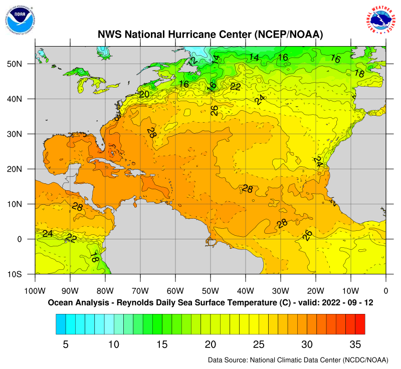
Florence is headed west. Besides going into an environment with much less shear, the storm will be encountering ocean water temperatures that are a bit warmer, that will help fuel intensification.
Here are the current Atlantic Ocean water temperatures. Florence, is currently around 25 deg. latitude and 52 degrees longitude, so that you can reference the location of the map below. The water temperature looks to be around 27(around 81 deg F), close to 28 deg. C right now...........and will be going to 28+, possibly 29 deg. which would be 84 deg. F.
To go from the C to the F scale, just multiply C X 1.8 +32 =F So 29 deg. C = 29 X 1.8 +32 = 84.2 F

Models continue with that farther south track. Florence should continue to strengthen and soon be a hurricane again..............then continue to strengthen, possibly rapidly at some point early next week.
Ocean water temperatures in the region where Florence is headed, feature a pocket with a bit of anamolously warm water(+2 deg. C above average) at around 29 deg. C, which is just above 84 deg. F.
The latest forecast is for Florence to be a major 145 mph hurricane in 5 days and a serious threat, getting close to the East Coast at that time.
Florence continues westward very slowly and getting stronger. Around 25 N 55 W and about to become a hurricane again. Could quickly strengthen from late Sunday-Tuesday and be a major hurricane with 140+ mph winds.
Location of East Coast strike still very uncertain but latest forecast average is around SC/NC border, late Thursday.
Florence is headed just north of west and then will curve more northwest, accelerate and strengthen. Possibly up to sustained winds of 150 mph in less than 72 hours from now.
This hurricane will threaten the East Coast with high winds, storm surge, then heavy rains.
Areas to the right of the center, will have the strongest winds. The forward speed of a hurricane adds to the winds on the right side of hurricanes.
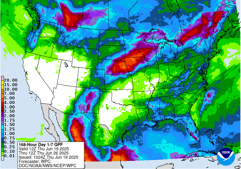
After Florence makes landfall, the remnants should slow down and maybe stall out, causing rain totals to potentially become excessive: Here is the forecast for days 3-7:

Mike do you think there is much of a chance that the front could push Florence to curve more to the north instead of stalling?
Look at the rainfall amounts predicted for the next week from Florence. Amounts below are for a 7 day period. The remnants of Florence, could cause additional rains on day 8 or even 9 that would add to these totals and result in totals of a foot!!!

I will probably start a new thread on Florence soon as we have some old stuff in this one.
... fueling up for landfall... quite hypnotizing...
