Posts below started on Saturday afternoon, so the oldest discussions are at the top......newest at the bottom. Most maps/links posted below are updated automatically, despite the older discussion times..........enjoy.
Florence continues to maintain the strength of 45 mph and so it remains a tropical storm might do this for another 12 hours or so. Having some of it's circulation still over the ocean is helping to keep it from weakening more. You can see from the radar loop/images, the well defined circulation(in E.South Carolina) and rapidly moving rain band wrapping around a center that is just drifting west:.
Some of the very heavy rain bands coming in off the ocean into North Carolina still have enormous rains and very strong winds. There are a couple of locations that have already received over 30 inches of rain............a state record from a tropical system.
http://www.nws.noaa.gov/radar_tab.php


For the complete weather that has much more go here:
https://www.marketforum.com/forum/topic/13112/
Note at the first link below that there are several tropical systems in the Atlantic. This is the peak hurricane season and not extremely unusual.
https://www.nhc.noaa.gov/graphics_at1.shtml?cone#contents
https://www.nhc.noaa.gov/text/refresh/MIATCDAT1+shtml/101450.shtml?

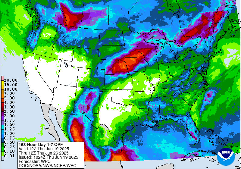
Total 7 day rains below
Here's the latest track of Florence from the 12z European model:
Florence is down to 45 mph and is in eastern SC. It will keep moving slowly west than start curving to the right and accelerating on Sunday. By Tuesday late Morning, Florence the depression will be passing close to Mikekempt's house in eastern PA. Then going bye bye for good by early Wednesday and good riddens after more than 2 weeks of being on weather maps.
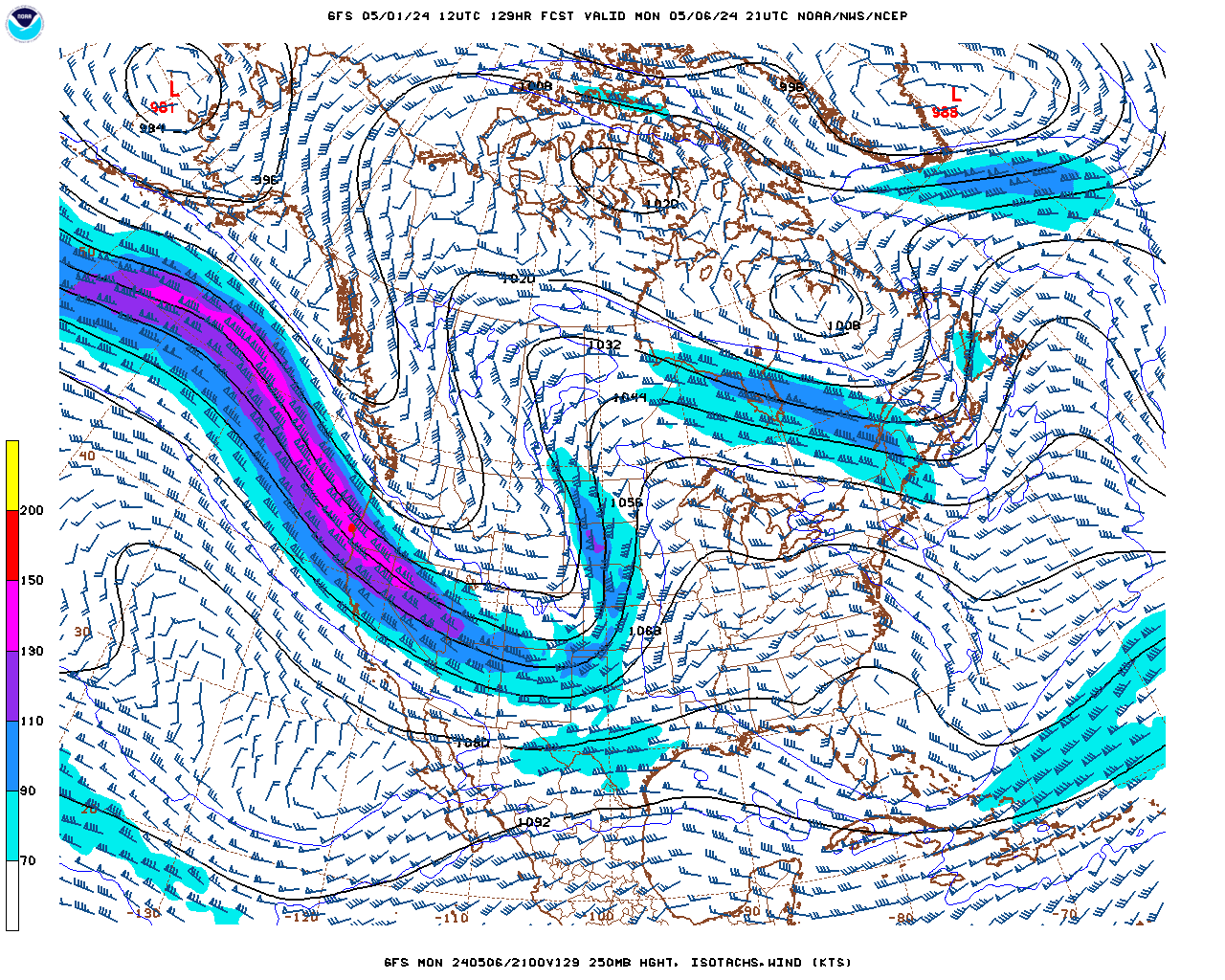
However, when Florence gets out into the N.Atlantic, is should regenerate as an extra tropical storm as it merges with tremendous mid latitude jet stream energy. The new storm will be mostly from that jet stream(that will have a max of around 180 mph!)
Trivia question: When was Florence dubbed a tropical storm?
How long did the longest lasting tropical storm last?
The wind history for Florence is below:
Jet stream in the middle of next week:
Forecast Hour: 129
Image URL: http://mag.ncep.noaa.gov/data/gfs/12/namer/250_wnd_ht/gfs_namer_129_250_wnd_ht.gif

Wettest ever tropical system for North Carolina since 1950:

This is going to put Florence in the top wettest tropical systems in the US.............since 1950. 68 years worth of records is actually not a very long time for weather records. For instance, half of the state high temperature records in the US were set in the 1930's. If the cut off was 1950, recent records would be the "hottest ever".
Since its still raining heavy in the wettest spots, Florence could make the top 5.
https://en.wikipedia.org/wiki/List_of_wettest_tropical_cyclones_in_the_United_States
| Rank | mm | in | |||
|---|---|---|---|---|---|
| Precipitation | Storm | Location | Ref. | ||
| 1 | 1538 | 60.58 | Harvey 2017 | Nederland, Texas | [1] |
| 2 | 1219 | 48.00 | Amelia 1978 | Medina, Texas | [1] |
| 3 | 1148 | 45.20 | Easy 1950 | Yankeetown, Florida | [1] |
| 4 | 1143 | 45.00 | Claudette 1979 | Alvin, Texas | [1] |
| 5 | 1033 | 40.68 | Allison 2001 | Northwest Jefferson County, Texas | [1] |
| 6 | 977 | 38.46 | Georges 1998 | Munson, Florida | [1] |
| 7 | 932 | 36.71 | Danny 1997 | Dauphin Island Sea Lab, Alabama | [1] |
| 8 | 756 | 29.76 | Unnamed 1960 | Port Lavaca #2, Texas | [1] |
| 9 | 707 | 27.85 | Alberto 1994 | Americus, Georgia | [1] |
| 10 | 695 | 27.38 | Beulah 1967 | Pettus, Texas | [1] |
Here's what I mean about the state high temperature records that go back to the 1880's:
https://en.wikipedia.org/wiki/U.S._state_temperature_extremes
Even that's only 130 years ago.
How are we doing in the Atlantic Basin compared to average in 2018
By metmike:
On average, an Atlantic hurricane season between 1981 and 2010 contained twelve tropical storms, six hurricanes, and three major hurricanes, with an Accumulated Cyclone Energy (ACE) index of between 66 and 103 units
We are now past the historical/seasonal peak in cyclone activity here in 2018. That doesn't mean that the next 45 days won't bring some monster storms or be very quiet.............each season is different and the 2nd half can be much different than the first half. We started September well below average but the last 2 weeks featured an explosion of tropical activity in the Atlantic.
We now have had 10 tropical storms(named to the letter J-Joyce) this is above average(12) for mid September.
We have had 5 hurricanes. This is also above average for just over the halfway point(3).
We have only had 1 major hurricane(Florence). This is below average at this point(1.5).
https://en.wikipedia.org/wiki/2018_Atlantic_hurricane_season
Florence has become the furthest east NW moving tropical cyclone on record back to 1851 to later hit the CONUS as it was moving NW in the 46W to 47W area. The prior record holder was storm #5 of 1906, which moved NW at 48W. Florence did so between 46.6W and 47.9W.
Thanks Larry!
Florence down to a Tropical Depression and picking up speed now on Sunday morning.
Tropical Depression Florence at 35 mph.
For the latest discussions, go here:
https://www.wpc.ncep.noaa.gov/discussions/nfdscc4.html
Heaviest rains from Florence are currently close to 34 inches.
...Selected preliminary Storm Total Rainfall in inches from 200 PM EDT Thu Sep 13 through 1000 AM EDT Sun Sep 16...
...NORTH CAROLINA... SWANSBORO 1.4 N                      33.89                    HOFMANN FOREST RAWS                  29.43                    SUNNY POINT RAWS                     27.22                    NATURE CONSERVANCY RAWS              26.77                    NEWPORT/MOREHEAD CITY NWS WFO        25.20                    EMERALD ISLE 0.2 ENE                 23.66                    WILMINGTON INTL AP                   23.59                    SUPPLY 4 NNW                         21.92                    CEDAR POINT 0.9 WSW                  21.73                    CROATAN RAWS                         21.68                    BOLIVIA 7.8 SW                       21.59                    LUMBERTON                            21.51                    MOREHEAD CITY .6 NW                  21.20                    MT. OLIVE 0.4 NW                     20.82                    ELIZABETHTOWN 6.2 NW                 20.17                    BACK ISLAND RAWS                     19.91                    TRENTON                              19.71                    MAYSVILLE 3.4 SSW                    18.50                    TURNBULL CREEK RAWS                  18.04                    ELIZABETHTOWN 4 NNE                  17.72                    KINSTON 6 SW                         16.01                    TRENT WOODS 1.3 SSE                  15.57                    RALEIGH-DURHAM INTL AP                4.43                    CHARLOTTE/DOUGLAS INTL AP             2.86