We are getting into a time frame when temperature forecasts have an increasing affect on natural gas prices. Here's the latest weather:
Update, latest weather for Sunday:
https://www.marketforum.com/forum/topic/15641/
Fridays weather link is below if you want to look at weather comments that are 2 days old(and don't matter anymore)
From Natural Gas Intelligence:
Bearish Overnight Weather Trends Pressuring November Natural Gas Futures
8:50 AM
Coming off Thursday’s 12.2 cent sell-off, the November natural gas futures contract was trading lower early Friday, down 2.2 cents to $3.176/MMBtu shortly after 8 a.m. ET as forecasters pointed to milder trends in the weather outlook overnight. s
I disagree and don't think models were milder overnight. Yesterdays updated November and Winter forecasts were very mild across much of the country. I think this put pressure on natural gas on Thursday and overnight.
Storage is Very Low for this time of year!!
Storage is below the bottom of the previous 5 year range and around 600 bcf below last year at this time!
This is why the temperature forecast matters....in the Summer/cooling season and Winter/heating season. We have a spike up of early season residential heating demand this week into next week. That caused a spike up in ng prices earlier this week.
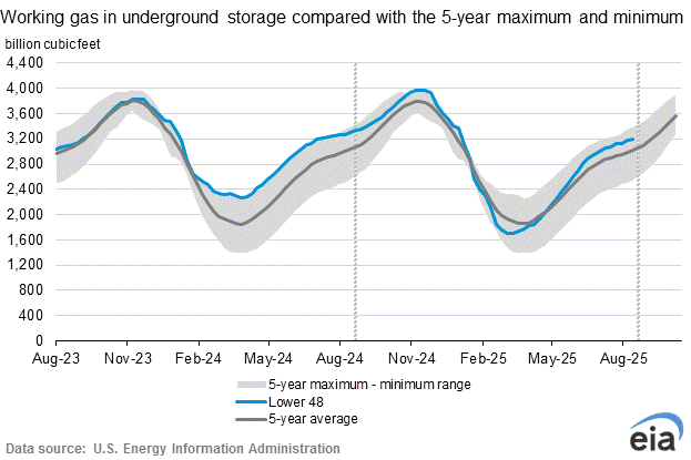
EIA injection on Thursday was +81 bcf.
| Working gas in underground storage, Lower 48 states Summary textCSVJSN | |||||||||||||||||||||||||
|---|---|---|---|---|---|---|---|---|---|---|---|---|---|---|---|---|---|---|---|---|---|---|---|---|---|
| Historical Comparisons | |||||||||||||||||||||||||
| Stocks billion cubic feet (Bcf) | Year ago (10/12/17) | 5-year average (2013-17) | |||||||||||||||||||||||
| Region | 10/12/18 | 10/05/18 | net change | implied flow | Bcf | % change | Bcf | % change | |||||||||||||||||
| East | 812 | 790 | 22 | 22 | 899 | -9.7 | 887 | -8.5 | |||||||||||||||||
| Midwest | 908 | 871 | 37 | 37 | 1,050 | -13.5 | 1,032 | -12.0 | |||||||||||||||||
| Mountain | 177 | 180 | -3 | -3 | 224 | -21.0 | 213 | -16.9 | |||||||||||||||||
| Pacific | 264 | 262 | 2 | 2 | 316 | -16.5 | 344 | -23.3 | |||||||||||||||||
| South Central | 877 | 854 | 23 | 23 | 1,150 | -23.7 | 1,166 | -24.8 | |||||||||||||||||
| Salt | 203 | 191 | 12 | 12 | 303 | -33.0 | 310 | -34.5 | |||||||||||||||||
| Nonsalt | 673 | 663 | 10 | 10 | 847 | -20.5 | 856 | -21.4 | |||||||||||||||||
| Total | 3,037 | 2,956 | 81 | 81 | 3,638 | -16.5 | 3,642 | -16.6 | |||||||||||||||||
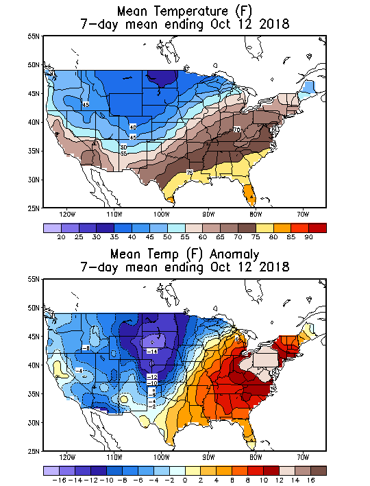
These were the temperatures that were used for the EIA report. Take a good look at that map. You don't see anomaly maps with such extremes in magnitude too often.
Natural Gas price charts
We finally broke out above $3!
A lot of volatility with the low storage. Prices have been gyrating up and down with the latest weather forecast............Monday was up as cold was added to the extended forecast.........lasting into early November.
Wednesday's forecast added more cold.....another spike higher resulted. Thursdays forecast took some cold away and gave us a mild Winter forecast.........so sharply lower.
Seasonals turn strongly negative here.......if the extended forecasts turn mild, look out below.........but low storage +very cold = higher price potential.
| Natural gas 3 months |
Naturalgas 1 year below
Naturalgas 5 years below
| Naturalgas10years below
|
Previous comments:
NG injection
Started by Jim_M - Oct. 18, 2018, 10:44 a.m.
Good morning everyone. We just breached the 3000 tcf mark. Clearly we are going to have a low injection, if not a withdrawal next week and possible even the week after.
Unless we warm up some in November, have we peaked? I don't think I would get much argument, that we are really close to the top in terms of NG injection.
++++++++++++++++++++++++++++++++++++++++++++++++
Agreed Mike. We do normally see a seasonal top this time of year. It will be interesting to see what a withdrawal or 2 and very low storage do to that seasonal trend.
++++++++++++++++++++++++
By patrick - Oct. 18, 2018, 11:34 a.m.
The anomaly map is cute but doesn't look too bad. A lot of heat where cooling is over & cold where not many people live.
The yellow boot of averageness stomping on San Francisco is a little disturbing.
++++++++++++++++++++++++++
By metmike - Oct. 18, 2018, 12:13 p.m.
Jim,
I think that recent price strength dialed in the cold.
The market trades on new information, which at this point, is the weather to end October and start off November.
+++++++++++++++++++++++++
By metmike - Oct. 18, 2018, 12:16 p.m.
Funny observation on the boot Patrick!
You are right about some of those very warm anomalies being in places that are often having heating demand............that, in this case spelled bearish warmth.
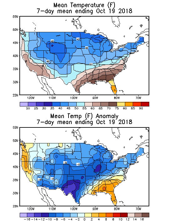
The upcoming weekly EIA report will be based on a week with a whopping 90 HDDs, which is normal for about 10 days later and is the earliest in Oct 90+ HDD week I could find going all the way back 20+ years! This will be the first good test to see the demand from significant HDDs since April. The CDD demand per CDD was pretty decent/didn't show looseness of supply/demand most of the cooling season. Now, we'll see how HDDs do.
Thanks Larry,
Here's the updated temperature map for that 7 day period:
http://www.cpc.ncep.noaa.gov/products/tanal/temp_analyses.php
Where do you get those HDD stats from?
At the link below, going to historical heating degree day data, I see
91 HDD for 10/19/2002 and
95 HDD for 10/17/2009
Mike,
My wording was wrong. I was looking at only FRI-THU weeks, which is what I use as EIA weeks. The 90 HDD for the week ending 10/18/18 is the earliest Fri-Thu week I could find with 90+. Here is the link to Fri-Thu DDs:
ftp://ftp.cpc.ncep.noaa.gov/htdocs/archives.wkthurs/
You are indeed correct in showing that those two calendar weeks in 2009 and 2002 were warmer weeks ending 10/18 or earlier. So, my statement was wrong. I should have said warmest so early going as far back as I could see for Fri-Thu weeks only. this link goes back only 15 years. I have other data I use to go back to the mid to late 90s but no link to it. Thanks for correcting me.
Aside: using calendar weeks as the AGA seems to be doing here can be very misleading. Calendar weeks and Fri-Thu weeks are often quite different even though it all evens out in the aggregate, of course.
NG opened lower. My sources show a warmer late week 2 vs Fri forecast.
Agree with that Larry.
I know that you aren't a big fan of the week 3 and 4 outlooks but that period had a huge shift overnight from below normal to much above normal temperatures.
Also, the NAO/AO indices were forecasted to crash hard on Friday but today, they bounce back up quickly, with alot of spread/uncertainty at the end of week 2.


Yeah, Mike, changes like today's vs yesterday's nearly polar opposite in the E 1/3 of the US for the entire weeks 3-4 make me laugh. Flippity flop. As you correctly put it, "low skill"! Way, way too unreliable. Even week 2 isn't so easy to forecast and can sometimes change rather drastically.
For yesterday's, you said "Strong Upper level ridge in Alaska/NW Canada/West Coast........... deep upper level trough downstream and very chilly temperatures for the US."
Tomorrow could revert back. Who knows? Flip a coin. These are so bad. The market is smart enough to know this and takes these flimsy CFS forecasts with a huge grain. Now in today's case, late week 2 as well as the entire weeks 1-2 netted out (slightly cooler early but much warmer later) are both warmer. That, alone is enough to bring NG down. Maybe this warmer weeks 3-4 gives the market a little more confidence in betting on a warmer pattern since it agrees with the warmer late week 2. But if weeks 1-2 are strongly one way and weeks 3-4 are strongly the other way, I know which will normally win out if wx is the main factor. It won't normally bet on a 2 week period that is so low skill vs a much higher skilled earlier two week long period. That wouldn't make any sense.