It's October 26th. A brand new day! Do something special for somebody to remember today! Seriously, don't just think about it for a moment......do it.
Scroll down and enjoy the latest comprehensive weather to the max!!
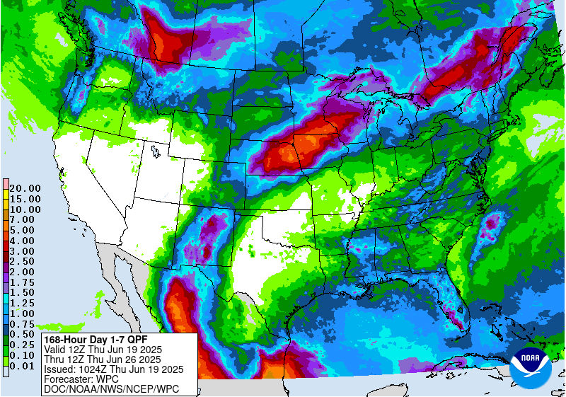
The latest rain forecasts for the next week are below. Dry pattern for Plains to Western Cornbelt. Wet to the east.
Some very weak remnants of Willa(that was a hurricane in the E.Pacific earlier this week) are moving up the East Coast right now.
Big rains next week Southern to Eastern Corbelt.
Day 1 below:
http://www.wpc.ncep.noaa.gov/qpf/fill_94qwbg.gif?1526306199054

Day 2 below:
http://www.wpc.ncep.noaa.gov/qpf/fill_98qwbg.gif?1528293750112

Day 3 below:
http://www.wpc.ncep.noaa.gov/qpf/fill_99qwbg.gif?1528293842764

Days 4-5 below:
http://www.wpc.ncep.noaa.gov/qpf/95ep48iwbg_fill.gif?1526306162

Days 6-7 below:
http://www.wpc.ncep.noaa.gov/qpf/97ep48iwbg_fill.gif?1526306162

7 Day Total precipitation below:
http://www.wpc.ncep.noaa.govcdx /qpf/p168i.gif?1530796126

Here are the latest hazards across the country. The dark purple is a freeze warning. The bright purple is a hard freeze warning. The light/bright blue is a freeze watch, darker/medium blue is a frost advisory. Gray is fog. Green is flood watch/warning. Pink is a Winter Storm Warning. Purple is a WW advisory.
https://www.spc.noaa.gov/ Go to "hazards"


| Low Temperatures Thursday Morning |

High Temperatures today and Saturday.
Very chilly Midwest to Northeast to East Coast. Warm West to Plains.


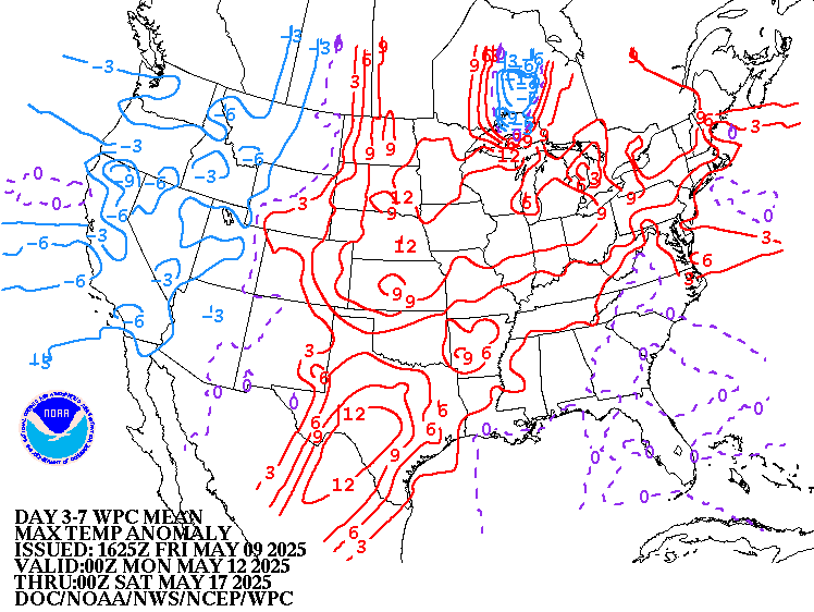
Highs for days 3-7:
Small fluctuations. Actually the update has a few big fluctuations.


How do these days 3-7 temperatures compare to average at this time of year?
Weak anomalies .........,but warming a bit in the East.

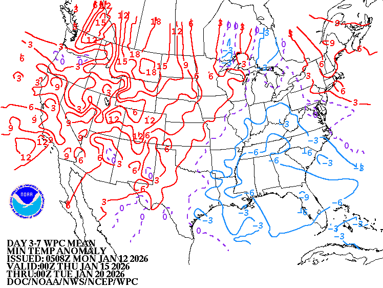
Low Temperature Departures:

Surface features for the same 3-7 day period:
Becoming much more active.

Current Dew Points

Latest radar loop.
Biggest action moving up the East Coast!
http://www.nws.noaa.gov/radar_tab.php

Rains the past 24 hours
![]()
You can go to this link to see rain totals from recent time periods:
https://water.weather.gov/precip/
Go to precipitation, then scroll down to pick a time frame. Hit states to get the borders to see locations better. Under products, you can hit "observed" or "Percent of normal"
Soil moisture anomaly:
Still wet in an enormous area. Drying will continue for the Western Midwest overall the next week.
Rains compared to average for the last 7, 14, 30 and 60 days.
Usually not updated for previous day until late the next day.
Note how incredibly wet it's been over the past 60 days over eastern 2/3rds of the country!
https://www.atmos.illinois.edu/~snodgrss/Ag_Wx.html


The top map is the Canadian ensemble average, the maps below are the individual members that make up the average
End of week 2....................0Z ensembles from Friday. Yesterday's view is still the same today "Deep trough/upper level low position key to the forecast......it's farther west today, at least for this model, which means wetter and possibly warmer in the East." but this model is not as warm as some.
++++++++++++++++++++++++++++++++++++++++++++++++++++++++++++++
Each member is like the parent, Canadian model operational model.......with a slight tweek/variation in parameters. Since we know the equations to represent the physics of the atmosphere in the models are not perfect, its useful to vary some of the equations that are uncertain(can make a difference) to see if it effects the outcome and how.
The average of all these variations(ensembles) often yields a better tool for forecasting. It's always more consistent. The individual operational model, like each individual ensemble member can vary greatly from run to run.........and represent an extreme end of the spectrum at times. The ensemble average of all the members, because it averages the extremes.............from opposite ends of the spectrum............changes much less from run to run.
360h GZ 500 forecast valid on Nov 09, 2018 00 UTC
360h GZ 500 forecast valid on Nov 10, 2018 00 UTC
Here are the 0Z GFS ensemble, individual solutions at 360 hours(2 weeks). Deep trough in the Northeast solution on some members yesterday is completely gone.
Widespread aggrement today on a more mild flow(west to east or southwest to northeast) with above normal temperatures across much of the country. Some solutions have an upper level trough(s) in the flow, deepest in the West.
Low confidence at this time frame!

The low skill, longer range CFS model for weeks 3-4.
Larry tells me that the source of this solution is a day old, so I am working on finding a source with the latest solution.
Enormous upper level ridge from Alaska to Central Alaska with near record warmth...........that spreads east across the entire US in mid November.
Much different than yesterday morning, which featured a huge cold trough in the center of the country(just a bit of the trough left for awhile today).
Much lower residential heating overall than yesterday!
Check in tomorrow to read something different............."low skill" (-:

Precip below:

National Weather Service 6-10 day, 8-14 day outlooks.
Updated early this afternoon.
Temperature Probability | |
Precipitation Probability | |
| the 8-14 day outlooks ArchivesAnalogsLines-Only FormatGIS Data | |
Temperature Probability | |
 | |
Latest, updated graph/forecast for AO and NAO here, including an explanation of how to interpret them. Both are predicted to increase back to positive at the end of 2 weeks and higher than yesterday.........which favors a warm weather regime for the mid November time frame that the market is trying to ascertain right now.
The 12Z operational GFS came out slightly colder for a few days early in the week 2 period(11-5 to 11-7)(typical for a run to run variation) with no noteworthy pattern changes from the previous runs.
The bounce in natural gas started over 90 minutes before this came out.
Last 12z solution below, then below that, the previous, 6z run solution for that period.
gfs_namer_252_200_wnd_ht | gfs_namer_252_500_vort_ht |
gfs_namer_252_1000_500_thick | gfs_namer_252_850_temp_ht |
6z operational GFS for 264 hours below:
gfs_namer_264_200_wnd_ht | gfs_namer_264_500_vort_ht |
gfs_namer_264_1000_500_thick | gfs_namer_264_850_temp_ht |
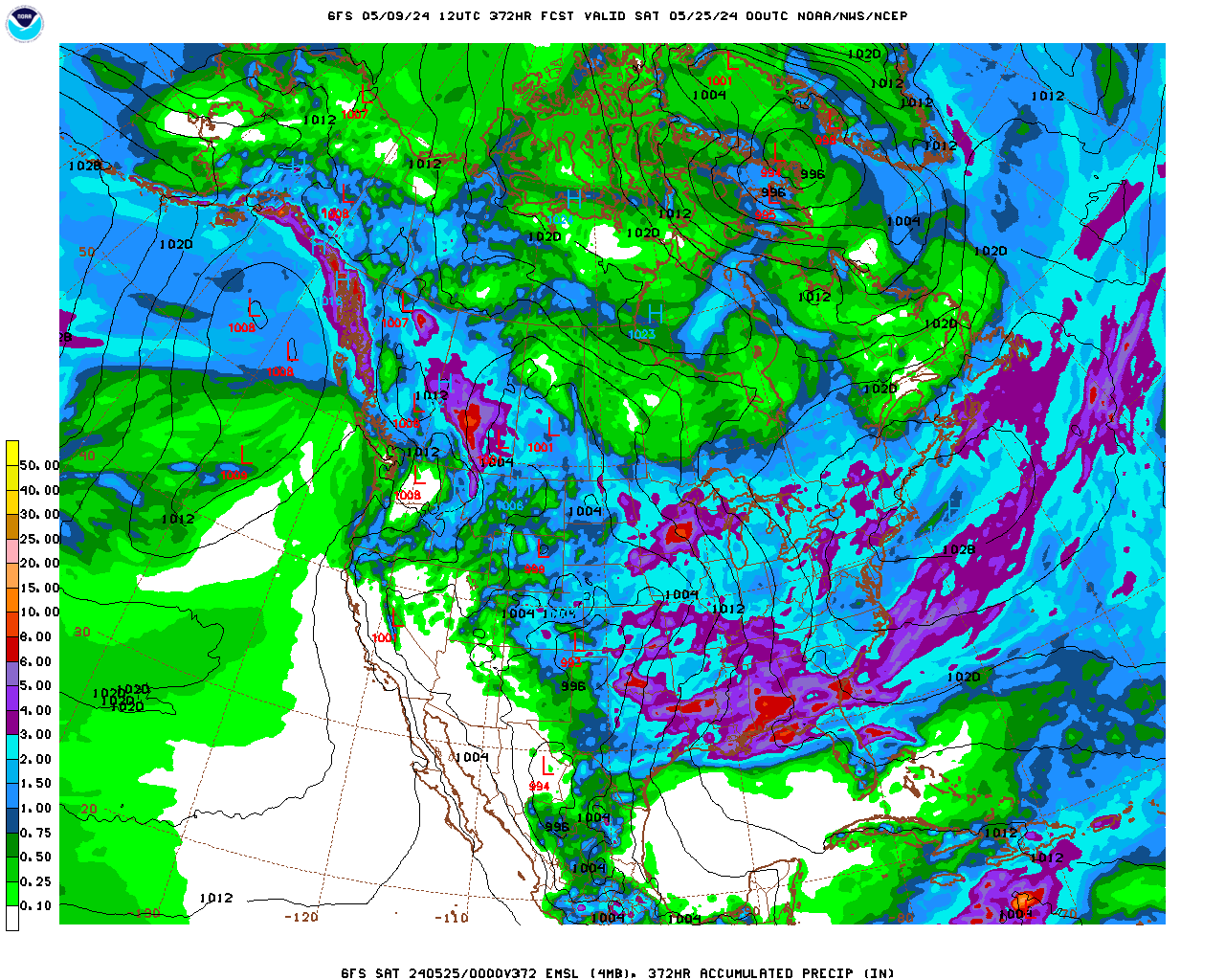
Here is the total precip for the next 16 days on the last 12z GFS. Very wet in the Southern and Eastern Cornbelt but not quite as wet as the previous 2 runs, that had in excess of 6 inches in a larger area of in the wettest spots in the Eastern belt.
Forecast Hour: 372
Image URL: http://mag.ncep.noaa.gov/data/gfs/12/namer/precip_ptot/gfs_namer_372_precip_ptot.gif
