
June is almost over!......time ticks by faster and faster!!! Do something to make somebody feel lucky today! Then, after observing the positive results, make a good habit out of it!
Scroll down and enjoy the latest comprehensive weather to the max...... occurring because of the natural physical laws in our atmosphere.
The long advertised BIG pattern change is here. Rains this week will not completely end....... a bit above average still in places but many water logged spots will be drying out............and have finally warmed up.
Heat ridge has built into the N.Plains. First heat wave of the year for N.Plains/Upper Midwest.
This pattern is much different than anything that we've seen for a very long time.
Will the heat ridge continue to retrograde west late in week 2 into the Rockies like the American models or will it try to move back east/southeast to the long lived position much of this year?
Guidance slightly cooler overnight....ridge builds west.
Here are the latest hazards across the country.
Purple/Pink/blue on land is cold/Winter weather. Brown is wind, Green is flooding. Gray is fog. Reddish is a red flag advisory.
Go to the link below, then hit the location/county on the map for details.
https://www.spc.noaa.gov/ Go to "hazards"

Current Weather Map
| NCEP Days 0-7 Forecast Loop | NCEP Short-Range Model Discussion | NCEP Day 3-7 Discussion |

Wind map Press down on this on the left with your cursor!


Current Jet Stream

| Low Temperatures Tomorrow Morning |

Hot!!
Temperature colors on the maps below still need to be adjusted down to cooler shades.


Highs for days 3-7:
Hot to very warm in much of the country.


Temperatures compared to average for days 3-7 below
Hot to very warm over much of the country.
https://www.wpc.ncep.noaa.gov/medr/medr_mean.shtml
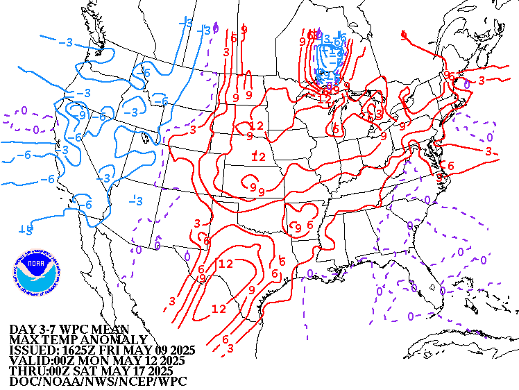
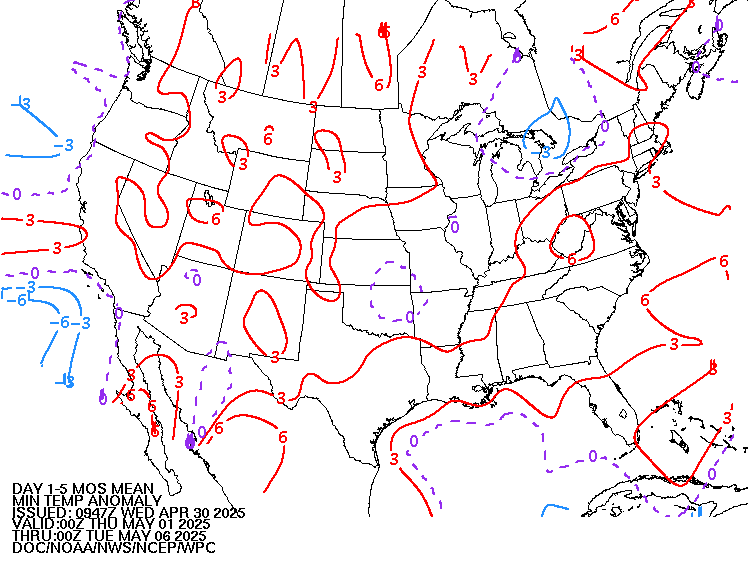
Weather maps for days 3-7 below
New pattern is happening now as the upper level ridging builds in the Plains. This is completely different than anything we've seen for a very long time and it will help to ease the intensity of the rains.
There will still be a meandering front, that serves as a boundary for east/southeast moving clusters of T-showers...........so for sure, this will not be dry.
Area with best rain chances has shifted too.... more northwest of the recently wettest locations.
Potential Ring of fire pattern developing with perturbations in the jet stream coming over the top and around the periphery of the heat ridge........firing up storm clusters that evolve in the N.Plains, then move southeast.

Liquid equivalent precip forecasts for the next 7 days are below.
Pattern has changed!! Rains have eased up in the wettest spots this week and shifted farther northwest. Not looking completely dry but the rains have shifted to a different location(that has not been as wet) and will not be as heavy.
Day 1 below:
http://www.wpc.ncep.noaa.gov/qpf/fill_94qwbg.gif?1526306199054

Day 2 below:
http://www.wpc.ncep.noaa.gov/qpf/fill_98qwbg.gif?1528293750112

Day 3 below
http://www.wpc.ncep.noaa.gov/qpf/fill_99qwbg.gif?1528293842764

Days 4-5 below:
http://www.wpc.ncep.noaa.gov/qpf/95ep48iwbg_fill.gif?1526306162

Days 6-7 below:
http://www.wpc.ncep.noaa.gov/qpf/97ep48iwbg_fill.gif?1526306162

7 Day Total precipitation below:
http://www.wpc.ncep.noaa.govcdx /qpf/p168i.gif?1530796126
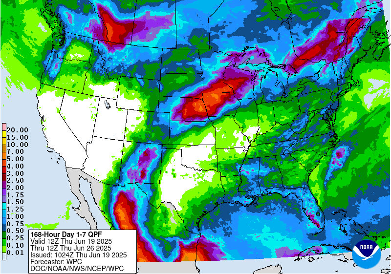
Mostly Marginal risk of Excessive Rainfall this week(slight risk today), Magnitude of heavy rains has eased up this week but not completely dry everywhere......in fact, above average rains still in some places...........mostly NOT the wettest spots.
Mesoscale Precipitation Discussions
Current Day 1 Forecast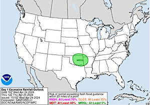 Valid 12Z 04/22/19 - 12Z 04/23/19 |
Day 1 Threat Area in Text Format
| Day 2 and Day 3 Forecasts |
Current Day 2 Forecast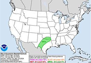 Valid 12Z 04/23/19 - 12Z 04/24/19 |
Day 2 Threat Area in Text Format
Current Day 3 Forecast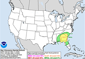 |
Slight risk of severe storms this week has shifted farther north.
Current Day 1 Outlook | Forecaster: Thompson/Squitieri Issued: 20/1624Z Valid: 20/1630Z - 21/1200Z Forecast Risk of Severe Storms: No Svr Tstms |
Current Day 2 Outlook | Forecaster: Broyles Issued: 20/0546Z Valid: 21/1200Z - 22/1200Z Forecast Risk of Severe Storms: Marginal Risk |
Current Day 3 Outlook | Forecaster: Broyles Issued: 20/0711Z Valid: 22/1200Z - 23/1200Z Forecast Risk of Severe Storms: Marginal Risk |
Current Day 4-8 Outlook |
Last 24 hour precip top map
Last 7 day precip below that
https://www.wunderground.com/maps/precipitation/daily

Current Dew Points
High moisture feeding north from the Gulf of Mexico...........also evaporating off of wet soils.

Latest radar loop
http://www.nws.noaa.gov/radar_tab.php


| (3400x1700 pixels - 2.2mb) Go to: Most Recent Image |

Go to: Most Recent Image
You can go to this link to see precipitation totals from recent time periods:
https://water.weather.gov/precip/
Go to precipitation, then scroll down to pick a time frame. Hit states to get the borders to see locations better. Under products, you can hit "observed" or "Percent of normal"
+++++++++++++++++++++++++++++++++++++++++++++++
Precipitation compared to average for the last 7, 14, 30 and 60 days.
East/Southeast Cornbelt is saturated but drying out!!!
Usually not updated for previous day until late the next day.
https://www.atmos.illinois.edu/~snodgrss/Ag_Wx.html


Soilmoisture anomaly:
These maps sometimes take a day to catch up to incorporate the latest data(the bottom map is only updated once a week).
East/Southeast Cornbelt is drying out.........not completely dry but drying. Rains shifted northwest where they are actually welcome(it was getting a bit dry in some places in the far north)
https://www.cpc.ncep.noaa.gov/products/Soilmst_Monitoring/US/Soilmst/Soilmst.shtml#
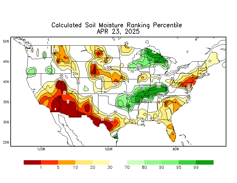

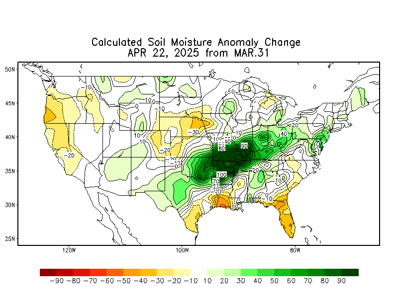
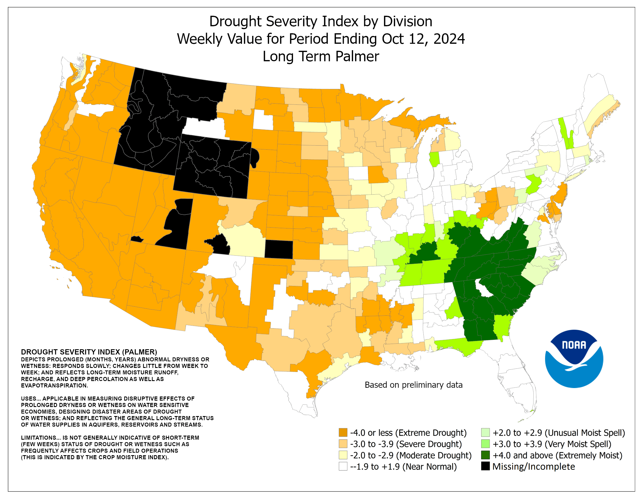
Currently, there is 0% of the main Cornbelt/Midwest with drought.........but it's been very dry along the Canadian border. There is drought in the Southeast.
The map below is updated on Thursdays.
The market will be STILL be keying on precip forecasts for planting concerns for the next 2 weeks. Just the beans now will be getting planted..........too late for corn planting....getting too late for bean planting pretty soon.
https://droughtmonitor.unl.edu/

The top map is the Canadian ensemble average, the maps below are the individual members that make up the average at the end of week 2.
+++++++++++++++++++++++++++++++++++++++++
Each member is like the parent, Canadian model operational model.......with a slight tweek/variation in parameters. Since we know the equations to represent the physics of the atmosphere in the models are not perfect, its useful to vary some of the equations that are uncertain(can make a difference) to see if it effects the outcome and how.
The average of all these variations(ensembles) often yields a better tool for forecasting. It's always more consistent. The individual operational model, like each individual ensemble member can vary greatly from run to run.........and represent an extreme end of the spectrum at times. The ensemble average of all the members, because it averages the extremes.............from opposite ends of the spectrum.........changes much less from run to run.
End of week 2....................0z ensembles:
Analysis starting from a week ago, ending with today:
Last week+ of analysis, starting with the day farthest in the past. This is an end of week 2 forecast!
Last Thursday: Trough along or just off the West Coast, upper level ridge downstream around the Rockies/Plains. Much warmer midsection than anything we've seen in a long time. Heavy rains easing up.
Friday: Upper level trough along the West Coast on the mean with downstream upper level ridging..........heat ridge. Most likely in the Plains.........on this model, the S.Plains.
Sunday: Upper level trough just off the West Coast. Upper level ridge across much of the country. This model is much warmer across the east than other models with its upper level ridge position late in week 2, which is always the period we cover on this page and the ones below.
Monday: Still the upper level trough just off the West Coast and a downstream heat ridge..........anywhere from the Rockies to S.Plains to points eastward
Tuesday: Trough just off the West Coast and big heat ridge just downstream.........possible trough along the East Coast(with cooler temps).......a bit deeper today.
Wednesday: Same as yesterday. Trough just off the West Coast and big heat ridge downstream. Maybe some troughing Upper Midwest to Northeast. This model is wetter than the other models.
Thursday: Heat ridge looking the most impressive farthest east on the Canadian model!! Still an upper level trough off the West Coast.
Friday: Upper level trough/low off the West Coast deeper and farther west...........so the downstream heat ridge backs up farther west and allows for more troughing and cooler weather Upper Midwest to East.
360h GZ 500 forecast valid on Jul 13, 2019 00 UTC
0Z GFS Ensembles at 2 weeks:
Analysis, starting with the oldest, ending with the most recent:
Last Monday: huge dome from Rockies to plains to w.gulf states. This would cause rains to ease up and shift the heat.
Tuesday: Heat ridge continues to look farther west on this model late week 2..............S.Rockies area, maybe S.Plains.
Wednesday: More ridging Rockies to N.Plains and some troughing in the East would shift the heat west and dry things out in the soggy midsection.
Thursday: Upper level ridge, Plains to Rockies. Much warmer in this area. Not as wet in the Midwest.
Friday: This model has the upper level heat ridge farther northwest vs the Canadian model on some solutions.........but it looks impressive.
Sunday: Pronounced heat ridge in N.Plains tries to retrograde west, to the Rockies and allows more cool, northwest flow downstream into the Midwest/Northeast.......on this model.
Monday: Upper level heat ridge the farthest west on this model........possibly in the Rockies. Other models are farther east. This model backs the heat up farther west and allows some cool air to push into the East........on some solutions. It is also fairly dry, with some solutions shutting down the rains.............hard to do with very wet soils, so that remains to be seen.
Tuesday: Upper level heat ridge somewhere and least likely in the Northeast, which may be on the cool side. This pattern is usually a very dry one but with wet soils, that may not be the case this time(just not excessive rains).
Wednesday: Heat ridge location around the Rockies. Maybe troughing in the Northeast. Heat would back out west and cooling farther east with this type of solution.
Thursday: Heat ridge much farther west on this model with cooling in the East.
Friday: Heat ridge shifts farther southwest and upper level trough is getting carved out in the Upper Midwest to Northeast with some cooling.

GFS Ensemble mean(average of all the individual solutions above). The first map is a mid/upper level map. The 2nd one is a temperatures map at around 1 mile above the surface. These are anomalies(difference compared to average). The daily analysis starts with the oldest and ends with the latest.
Last
Tuesday: Weak positive anomaly in the Rockies with weak negative anomaly in the Southeast. This is much different than recent patterns which would be drier and feature the heat much farther west than it has been. Upper level ridging in the Southeast and and South has been an important link to recent excessive rains that travel around the periphery and feed off the very warm, humid air it pumps up. If that goes away..........so do the heavy rains.
Wednesday: Large area with a weak positive anomaly northwest 2/3rds and weak negative anomoly Southeast suggests heat backing westward and things drying out using the same reasoning as yesterday.
Thursday: Modest positive anomolies across much of central and western North America. very weak negative in the southeast. Favorable for widespread warmth and not as wet.
Friday: Positive anomaly in Western North America extending eastward. Widespread warmth, to in some cases hottest temperatures of the year so far. Not a very wet pattern but there will still be rain events.
Sunday: Positive anomaly here late in week 2 is shifted a bit to the northwest, so the upper level heat ridge could also shift, which MIGHT cause a change downstream with any potential cool intrusions.
Monday: This model features widespread positive anomalies at higher latitudes. Slightly below average anomalies in the Southeast. Ordinarily, this is a fairly dry pattern with the heat towards the north and not the south.
Tuesday: Positive anomalies in the high latitudes to the Rockies. Weak negative anomalies in the Southeast. This is usually pretty dry, maybe on the cool side in the Southeast/South.
Wednesday: Positive anomaly in the N.Rockies(very warm west), slight negative in the Southeast..........favors cool there. Generally, not a wet pattern but we have wet soils that will re cycle moisture surface moisture and a potential "ring of fire" pattern that would feature perturbations coming over the top of the heat ridge and tracking southeast into the Midwest.
Thursday: Positive anomaly from Alaska, extending to the N.Rockies/Plains Weak negative anomaly in the Southeast. This would favor the warmth farther west but doesn't agree with other models.
Friday: No extreme anomalies.
NCEP Ensemble t = 360 hour forecast
Latest, updated graph/forecast for AO and NAO here, including an explanation of how to interpret them.
Previous analysis, with the latest day at the bottom for late week 2 period.
Last Tuesday: All just below or close to zero. Nothing big, although the PNA is fluctuating in week 2 with the potential pattern change.
Wednesday: All just below zero and not telling us much.
Thursday: NAO and AO both below zero by a bit. PNA gyrating wildly on either side of zero.
Friday: Still negative AO and slightly neg. NAO with PNA jumping eradicately above and below zero.
Sunday: Negative AO, a bit negative NAO with PNA wildly fluctuating during week 2 because its extremely sensitive to the exact location of the upper level trough and ridge out west and the exact position has uncertainty. That location will also play a role in the weather downstream for much of the US.
Monday: Near zero to slightly negative for the AO, NAO. PNA spikes down then up at the end of week 2, related to uncertain location of trough/ridge couplet in the West.
Tuesday: All close to or just below 0.
Wednesday: AO and NAO slightly negative. PNA going from negative back to 0 at the end of 2 weeks.
Thursday: AO and NAO slightly negative. PNA going from moderately negative to a quick bounce back to 0 at the end of week 2. Uncertainty out West during week 2.....with downstream implications.
Friday: AO and NAO slightly negative. PNA goes from negative to jumping up to 0 at the end of week 2............from the upper level trough/ridge couplet shifting farther west...............and more cooling possible in the Midwest/East.
https://www.marketforum.com/forum/top
National Weather Service 6-10 day, 8-14 day outlooks.
Tues: Heat shifting west, heavy rains easing up/shifting as week 2 progresses.
Wed: Pattern change continues for this period. Heat shifting west to the middle of the country........heavy rains ease up/drying out.
Thursday: Same pattern change. Heat shifts west into the Plains. Heavy rains ease up but there is still some rain.
Friday: Same forecast philosophy. Heat centered in the N.Plains, heavy rains ease up but not completely dry.
Sunday: Same theme but potential changes late in week 2 in the location of the N.Plains heat ridge.....shifting farther northwest??
Monday: Heat in the N.Plains. Will this continue well into July? Rains continue because of wet soils but the actual pattern is a dry one for some locations........ absolutely no heavy rain signal.
Tuesday: Heat in the N.Plains still. Cool in the South. Usually a dry pattern but with wet soils, the NWS may still add alot of green to dial that element in .......from the abundant surface H2O being recycled.
Wednesday: "Heat could be backing up westward a bit." The NWS does not have this at all today. I realize, looking at the big picture that I am giving most weight to the GFS ensembles with my late week 2 outlooks......which has the heat much farther west and is much cooler in the East than the NWS and the European Ensembles. The GFS might be right of course but this observation is good to note in the future for me when looking at the extended maps.
Thursday: Heat ridge location??? The Canadian model is most bullish today with it farthest east. Rains will probably stay above because of wet soils recycling the moisture but the pattern could start drying out with a heat ridge of this potential magnitude.
Friday: Heat ridge backs up west as the GFS products have been showing all week and other models following overnight. Heat shifts farther west, cooling in the East/middle of the country. This can sometimes be a dry pattern but probably not this time with wet soils and northwest flow ushering in perturbations that track across the Cornbelt.
Temperature Probability
| the 8-14 day outlooks ArchivesAnalogsLines-Only FormatGIS Data | |
Temperature Probability | |
 | |
Slight risk for an excessive rain event in early July. ........I disagree with this assessment by the NWS.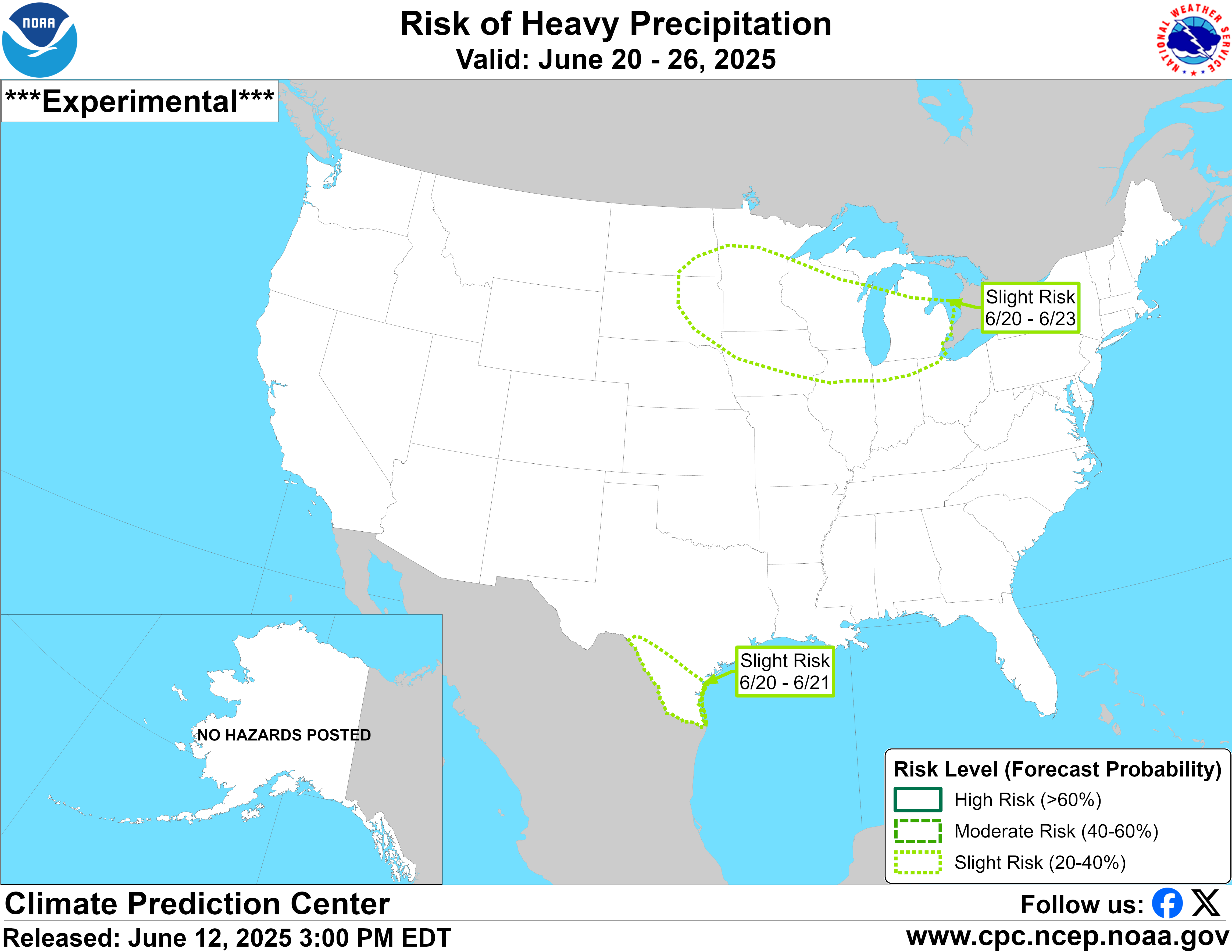
Potential for excessive heat in week 2. 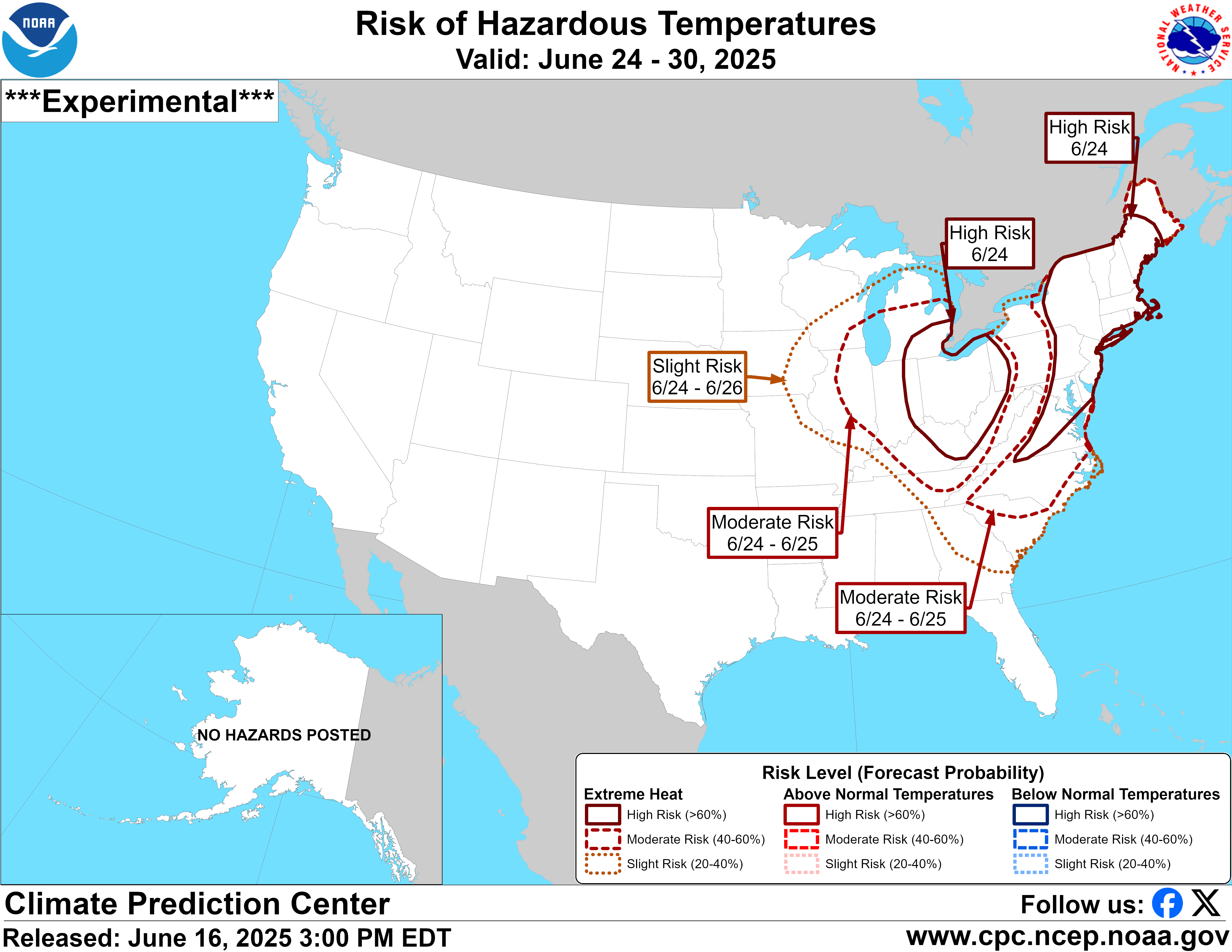
Previous comments:
By mcfarm - June 24, 2019, 11:26 a.m.
just an update on our conditions...rain yesterday, last nite and now up to 70 degrees with what? well rain of course
+++++++++++++++++++++++++++++++++++++++++++
By tjc - June 24, 2019, 4:24 p.m.
3 pm central Heavy rain all along I80 north central Illinois .5 inch est. came real fast that after .2 in a.m.
+++++++++++++++++++++++++
Re: Re: Re: Re: Weather Monday
By metmike - June 24, 2019, 5:31 p.m.
Thanks for the report tjc,
Here in the sw corner of Indiana, where we got lucky and actually had some warm/dry weather in May that allowed for some early planting then(compared the rest of IN, that corn is almost chest high and looks pretty good.
In many years, our earliest planted corn would be getting ready to tassle within a week.
At our house in the last 72 hours we had 6 different rains that totaled just over 2 inches. We live at the top of a hill and for the last 2 days, when you walk on the ground outside, the water squishes out, sort of like when you squeeze a sponge.
Our forecast is for no rain to a slight chance on some days with highs around 90 for the next week..............almost perfect.
++++++++++++++++++++++++++++++++++++++++++++++++++++++++++++++++
By mcfarmer - June 27, 2019, 11:31 a.m.
Believe it or not some of the earlier planted corn that went in under much less than ideal conditions was starting to roll a little yesterday.
Oddly, the low ground was rolling more than the lighter soils due to compaction and reduced root growth on the wetter ground.
We are getting a very nice rain this morning, looks like a half inch which should be just right.
I have the swather hooked up waiting for the young fellow who buys my hay to give me the go ahead to cut it down. He has his down now and doesn’t want it all down at the same time.
+++++++++++++++++++++++++++++++++++++++++++++++++++++++++++++
Thanks mcfarmer! Yeah, it was getting pretty dry in the northwest half of the belt before the pattern shift this week.
Interesting longer range, low skill weeks 3-4 outlook for late July. Drying out???
With average temps in the midsection, hot elsewhere.
| Week 3-4 Outlooks | ||
| Valid: 13 Jul 2019 to 26 Jul 2019 Updated: 28 Jun 2019 | ||
| Please provide comments using the online survey. | ||
Temperature Probability | Precipitation Probability (Experimental)  | |