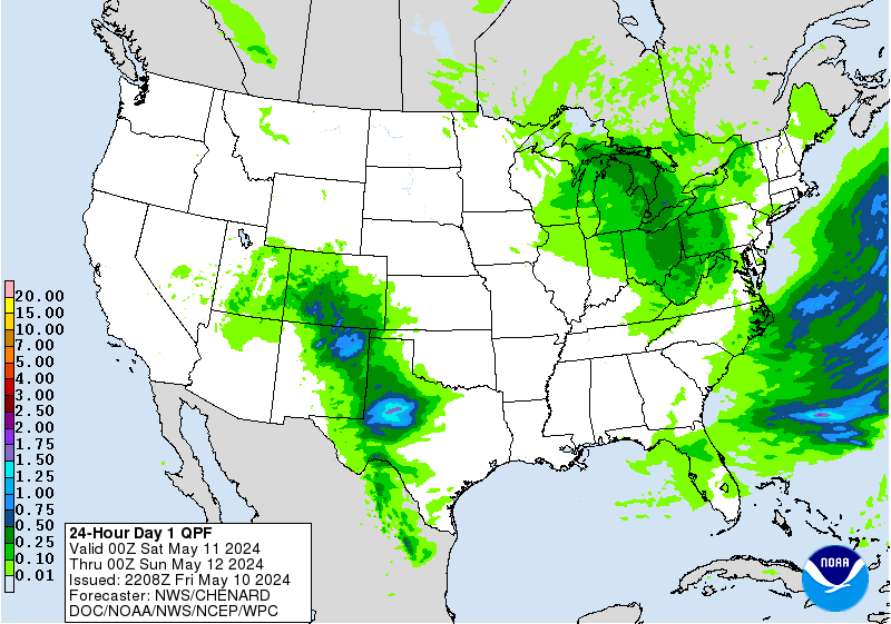
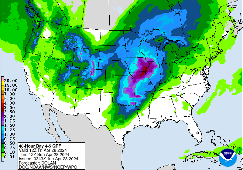
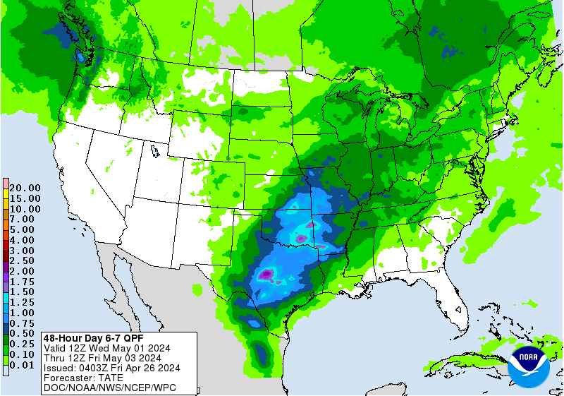
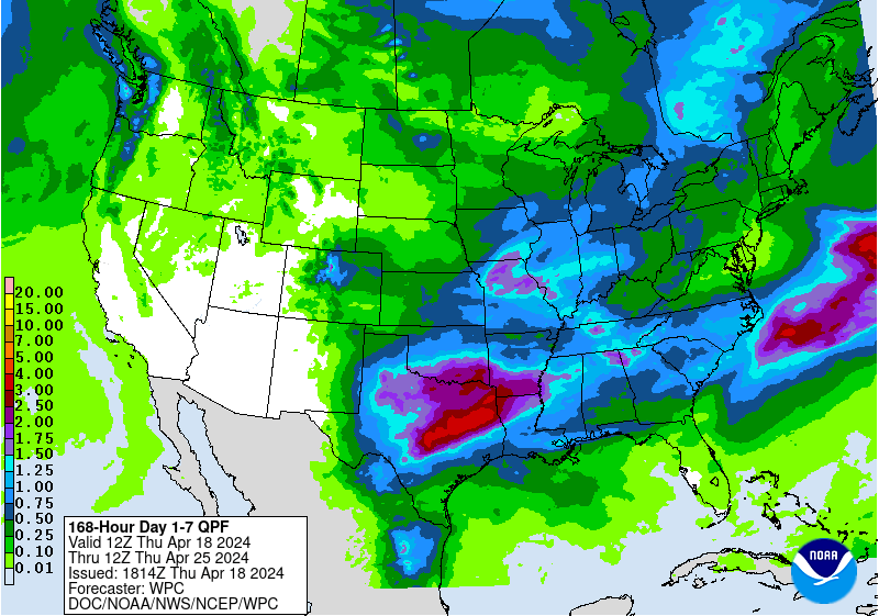
Rains the next 7 days:
http://www.wpc.ncep.noaa.gov/qpf/fill_94qwbg.gif?1526047082192
http://www.wpc.ncep.noaa.gov/qpf/day2.shtml
http://www.wpc.ncep.noaa.gov/qpf/day3.shtml
http://www.wpc.ncep.noaa.gov/qpf/95ep48iwbg_fill.gif?1526047006
http://www.wpc.ncep.noaa.gov/qpf/97ep48iwbg_fill.gif?1526047006
Total rains:
Severe storm risk the next few days:
http://www.spc.noaa.gov/products/outlook/
 | Forecaster: Edwards/Mosier Issued: 11/1247Z Valid: 11/1300Z - 12/1200Z Forecast Risk of Severe Storms: Slight Risk |
Current Day 2 Outlook | Forecaster: Kerr Issued: 11/0523Z Valid: 12/1200Z - 13/1200Z Forecast Risk of Severe Storms: Slight Risk |
Current Day 3 Outlook | Forecaster: Kerr Issued: 11/0729Z Valid: 13/1200Z - 14/1200Z F |
7 day forecast for Northeast IA.........one of the wet places. Should have a huge warm up early next week:
Today
Periods of showers and thunderstorms, mainly before 3pm. High near 48. East wind 11 to 13 mph. Chance of precipitation is 90%. New rainfall amounts between a quarter and half of an inch possible.
Tonight
Showers and thunderstorms likely before 4am, then a chance of showers. Cloudy, with a low around 42. Northeast wind 8 to 10 mph. Chance of precipitation is 60%. New rainfall amounts between a quarter and half of an inch possible.
Saturday
A 40 percent chance of showers. Cloudy, with a high near 58. Northeast wind around 10 mph. New precipitation amounts of less than a tenth of an inch possible.
Saturday Night
A 40 percent chance of showers. Mostly cloudy, with a low around 46. East wind 5 to 9 mph. New precipitation amounts of less than a tenth of an inch possible.
Sunday
Mostly cloudy, with a high near 69. East wind 5 to 7 mph.
Sunday Night
A 20 percent chance of showers after 1am. Mostly cloudy, with a low around 53. Light and variable wind.
Monday
Mostly sunny, with a high near 78. Calm wind becoming southeast around 5 mph in the afternoon.
Monday Night
A 50 percent chance of showers and thunderstorms. Mostly cloudy, with a low around 61. Southeast wind 3 to 5 mph.
Tuesday
A chance of showers, with thunderstorms also possible after 1pm. Mostly cloudy, with a high near 81. Southwest wind 3 to 6 mph. Chance of precipitation is 50%.
Tuesday Night
A 40 percent chance of showers and thunderstorms before 1am. Mostly cloudy, with a low around 61. Northwest wind around 5 mph becoming light and variable in the evening.
Wednesday
A 30 percent chance of showers and thunderstorms. Partly sunny, with a high near 81. West wind around 6 mph becoming north in the afternoon.
Wednesday Night
Partly cloudy, with a low around 55. Northeast wind around 6 mph.
Thursday
A 20 percent chance of showers. Partly sunny, with a high near 73. Northeast wind 7 to 9 mph.
Am a bit surprised that we are this weak with so much rain coming to the wet areas the next several days.
The just updated NAM has increased rain amounts in northeast IA.

Still tons of rain almost everywhere on the latest 12z GFS thru 16 days.
Guess we don't have to worry about a drought for a long time.
Forecast Hour: 372
Image URL: http://mag.ncep.noaa.gov/data/gfs/12/namer/precip_ptot/gfs_namer_372_precip_ptot.gif

Last 18z GFS still has tons of rain the next 2 weeks:
Forecast Hour: 384
Image URL: http://mag.ncep.noaa.gov/data/gfs/18/namer/precip_ptot/gfs_namer_384_precip_ptot.gif

Extended guidance, warm and, you guessed it.................wet.
 |
Precipitation Probability |
Looky here though on the experimental week 3 and week 4 projection, still very warm but NOT wet. The N.Plains to Upper Midwest to Great Lakes have normal precip but south of that is below average.
What are the chances of that verifying?
The warm part is probably close to 70%.
The dry part? Maybe 55%?
If we get inches of rain prior to this, it will not be AS bullish. However, if temperatures are A to MA over a large part of the Cornbelt and we have below normal rains(lets say for the 2 week period noted in this outlook) it will turn bullish.
Note the markets reaction today to tons of rain coming up...........despite a bullish crop report yesterday. So its rain makes grain mentality right now.
| Week 3-4 Outlooks | ||
| Valid: 26 May 2018 to 08 Jun 2018 Updated: 11 May 2018 | ||
| Please provide comments using the online survey. | ||
Temperature Probability | Precipitation Probability (Experimental)  | |
