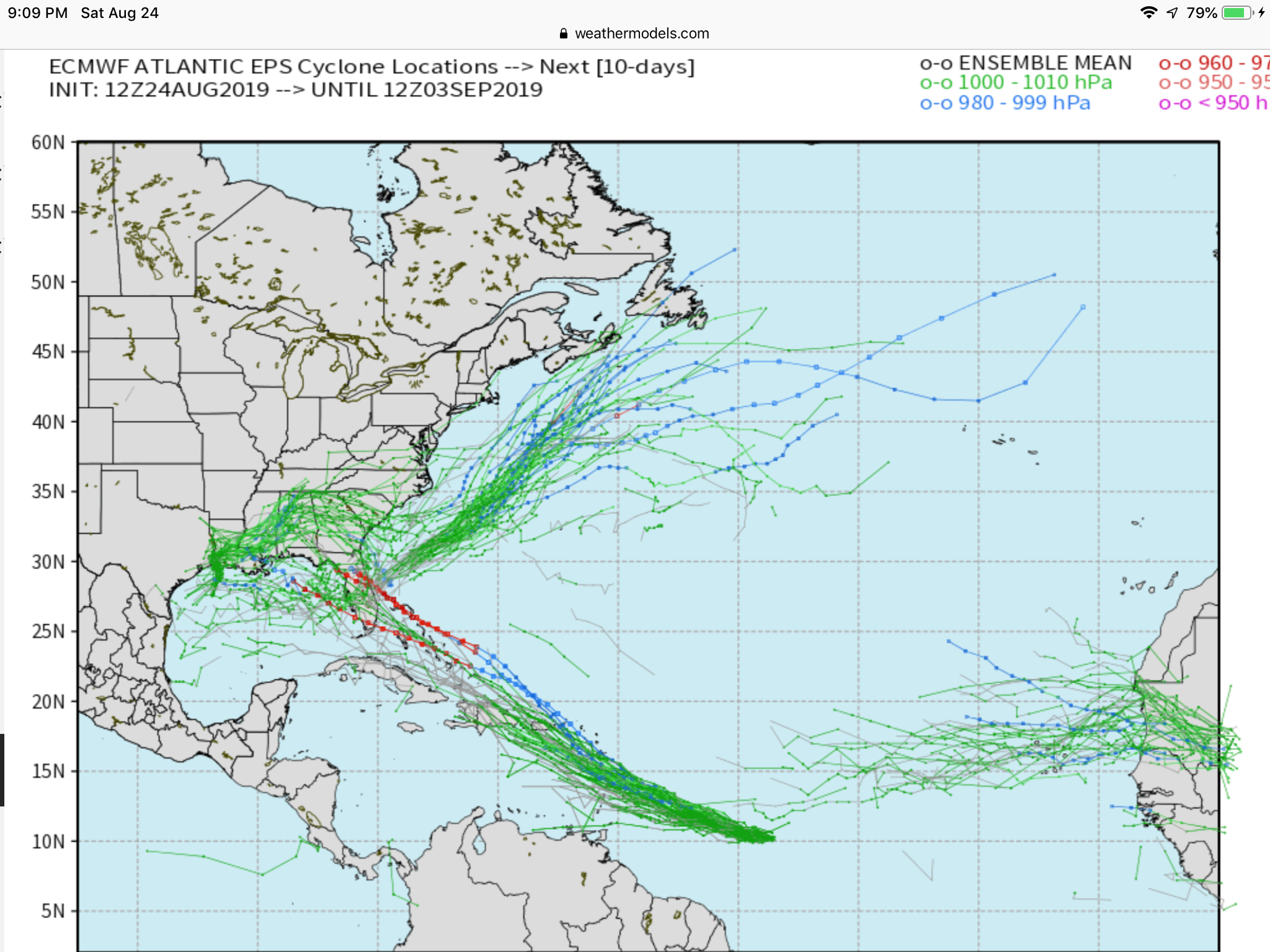
Newly designated Invest 99L is located near 10N, 42W, and is moving slowly WNW. Model consensus is increasingly doing something with this as it heads slowly in the general direction of the Lesser Antilles. Model consensus doesn’t get it to the vicinity of the Lesser Antilles til about Wednesday of next week. More models are now forming a tropical cyclone out of this within the next couple of days. Current satellite and other data shows it may be developing now. Don’t be surprised if this is designated a tropical depression within the next 24 hours.
Where it would go after the Lesser Antilles vicinity is very hard to say, especially since it is moving slowly. It could end up moving toward the E Bahamas and recurve sharply before reaching the US E coast and possibly threaten Bermuda. But if it keeps moving WNW, it could threaten Virgin Islans/Puerto Rico and even further west. That kind of track could potentially place the US east or even Gulf coast at risk assuming it were to hold together. At this point, I think the odds are a good bit under 50% for a CONUS hit owing to track uncertainty, slow movement, and whether or not there’s even a tropical cyclone then, but I don’t think they’re very low either. Something to monitor is best way to put it.
Thanks much Larry!
It will be extra fun monitoring the tropics this season with the expertise of you and Grant(which exceeds mine in many aspects of tracking/monitoring tropical weather).
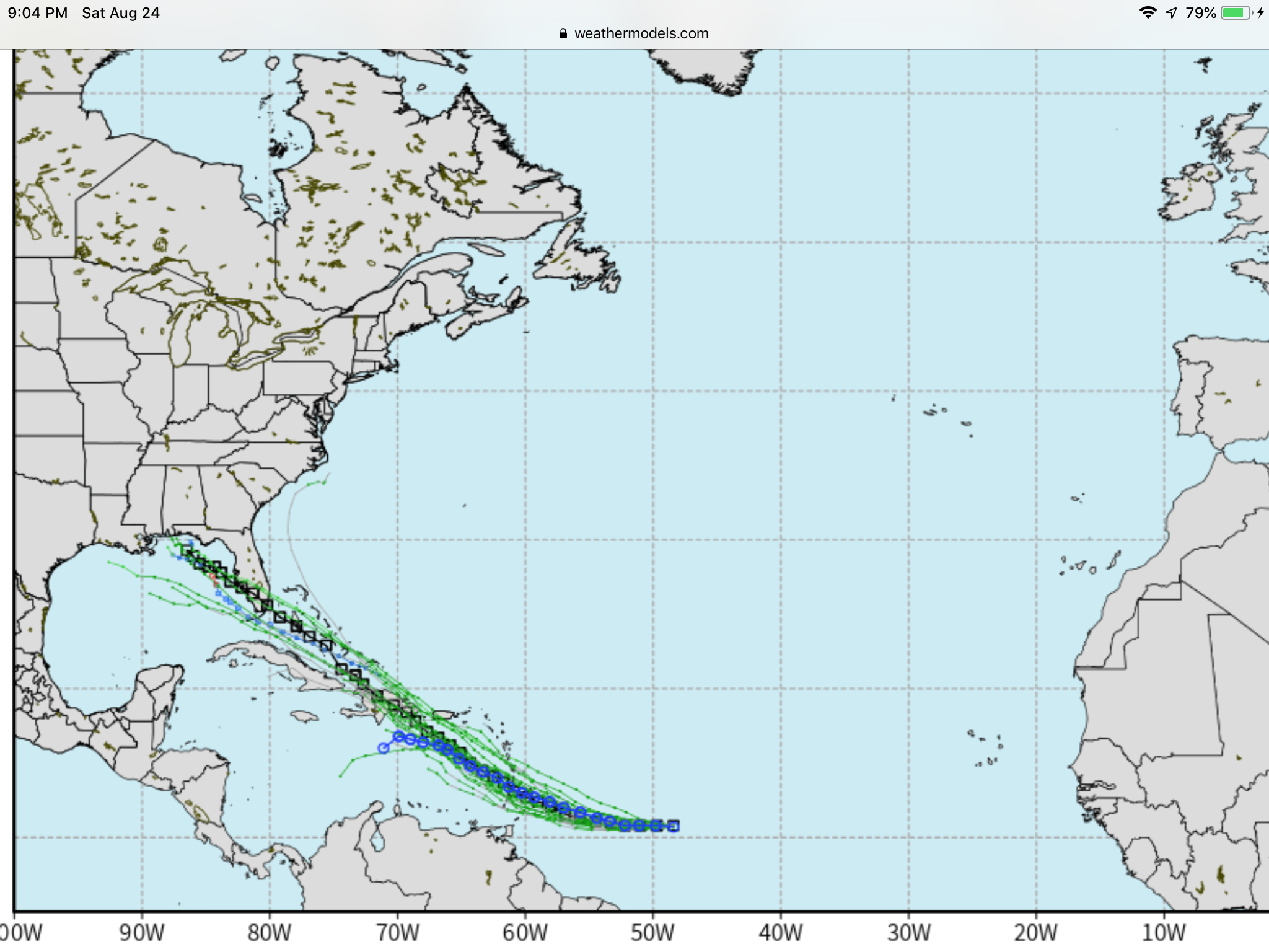
The operational GFS and EURO develop this system and bring it towards the Windward Islands. The GFS is much stronger. Both models shear this system out shortly after reaching the Islands. The Ensemble pattern shows a strong trough over the eastern US and the Bermuda High becoming elongated under this trough. If this system can survive the shear, it would likely move well west into the Caribbean and then the Gulf could be a threat. The other scenario I see is the east coast trough being delayed and could cause this system to shoot up north but remain well off the east Coast. Both the EURO and GFS hint of a system developing along a stalled front along the southeast coast. The Euro brings it in to the central Gulf Coast and the GFS skirts the SE coast. Both appear weak. Gong to be fun to watch over the next few weeks.
·
The 12z weather model updates arriving for newly designated Tropical Depression 05L in the Atlantic well east of the Lesser Antilles. Good news so far is that it is weak & not in a hurry to get stronger. GFS 12z maxes out as weak Tropical Storm thru 5-days. (
The other area of high-interest off the Florida / U.S. Southeast coast is not developed by GFS -- strangely enough. 00Z EPS guidance was considerably more bullish with multiple members with strong hurricane development -- safely away from U.S. East Coastline.
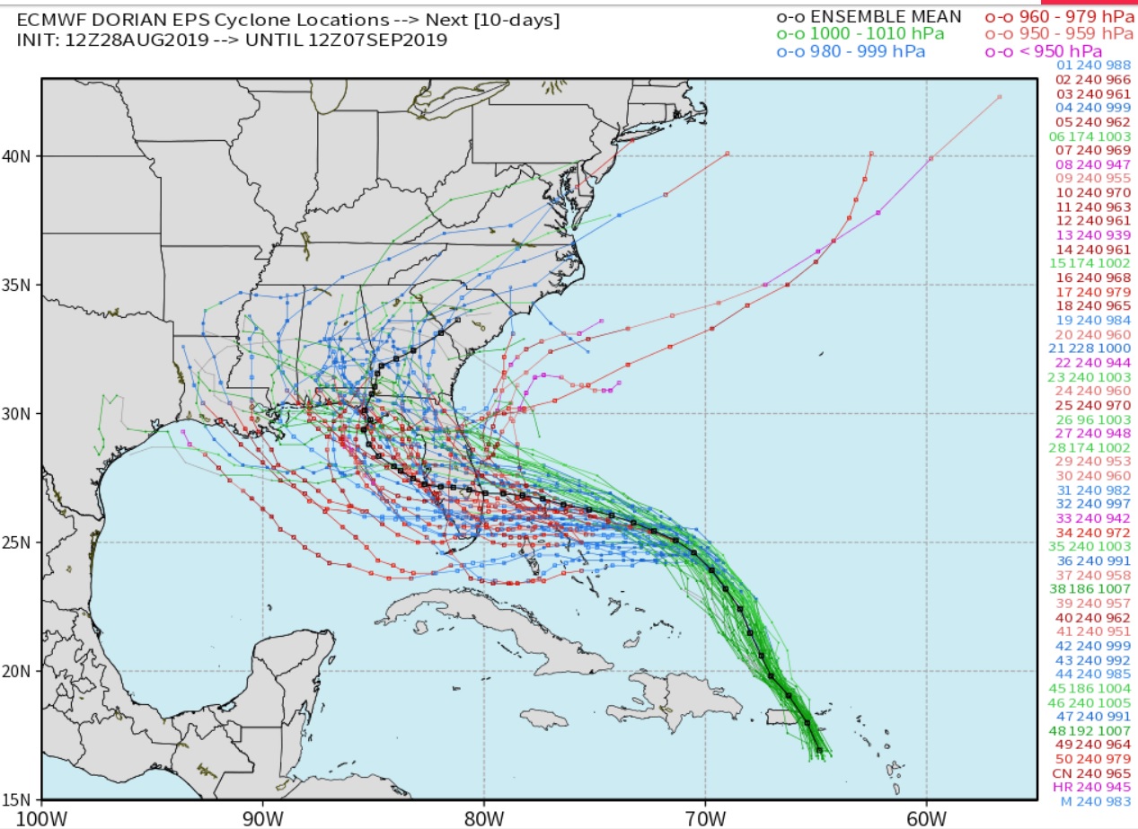
As of 5 PM today, this was upgraded from TD5 to TS Dorian. The NHC forecasts it to get to the Leeward Islands Tuesday as a hurricane and then into the NE Caribbean. This is not a fast mover. So, unless it falls apart, this will be on the maps for quite a long time (as long as 2 weeks or so if it gets into the western Gulf).
GFS ensembles are locked in to a path
Here is a look at the EURO ensembles. The operational models GFS and EURO seem to move it over Hispaniola which would break it apart. If it stays south of Hispaniola or moves through the Florida Straits it will be with us a while. Now we watch.
I should clarify my previous statement about moving through the Florida Straights. A few of the Euro ensembles have this system moving staying north of Hispaniola and then moving through the Straights. This will likely not happen. It looks very likely this will I’ve over Hispaniola which would likely tear the circulation apart due to the mountainous terrain. Then the remains will move through the Straights but will likely have a difficult time to redevelop. The latest EURO ensembles are once again shearing this thing out after the windward islands.
Thanks so much for the updates. Here are some links from the NHC to get the latest:
|
https://www.nhc.noaa.gov/graphics_at5.shtml?key_messages
![[Key Messages]](https://www.nhc.noaa.gov/storm_graphics/AT05/refresh/AL052019_key_messages+png/145247_key_messages_sm.png)
Using my eyeballs, I roughly estimate 75% of the 51 or so 12Z Euro ensemble members have a TD+ and 30% have a H at any point off the SE US coast. At least half of these then go into the Gulf. These are big upticks from the 0Z version. This is despite Dorian possibly weakening now and with tough times possibly ahead til out of the Caribbean.
The EURO really wants to bring this into the Gulf.

Thanks Grant!
Looking over the latest model data the EURO GFS and Canadian all show a weakness in the 500mb level producing a trough towards the NE. The GFS is moving Dorian a little slower at first meeting up with that weakness over the east coast and moving Dorian to the Outer banks. The Canadian and EURO have the weakness farther west with the EURO the farthest west. This moves Dorian in the Gulf and on shore along the central Gulf Coast. Interesting note. The NAVGEM turns Dorian into a monster across far southern Florida then up to the Florida panhandle. Curious if the possibility of Dorian moving in the Gulf is impacting NG. It’s up right now but non of the models at this time take it over platforms.
Grant,
I apologize for completely overlooking this but NGU, the front month expires today.
The day before and the day of expiration of ng front month futures is noted for wild spikes.
I assume that because volume is down to almost nothing and the remainder of the longs/shorts are forced out. The spike can often be against a long lived trend, maybe because those are the ones left.
Volume right now in the Oct contract is approaching 60K while its still below 4K in the expiring Sept contract.
With regards to Dorian. There is an outside chance that this is having an influence but it seems unlikely.
From NGI this morning: Weather Outlook ‘Singularly’ Neutral as Natural Gas Futures Called Higher
That make more since. Thanks Mike.
Cotton on the other hand is probably getting a bit of support because of the threat to the crop in the southeast(looks like a close call for the GA crop that was annihilated by Michael last year but it should be ok this time)!
Cotton conditions deteriorated 6% too on Mondays rating which is helping
https://release.nass.usda.gov/reports/prog3519.txt
7 Day Total precipitation below:
https://www.wpc.ncep.noaa.gov/qpf/p168i.gif?1566925971

Plenty warm water in this part of the Atlantic............and the GOM below that.
You basically need 27+ deg. C or 80+ deg. F.
30 deg. C is up around 86 deg. F
29 deg. C is around 84 deg. F.
Just multiply deg C by 1.8 and add 32 to get deg. F. https://www.ospo.noaa.gov/data/sst/contour/gulfmex.cf.gif

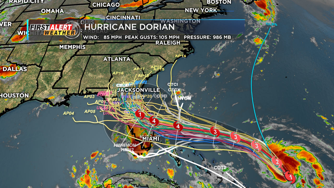
Dorian forecast has increased the intensity. NHC now expects a cat. 3 hurricane slamming into Northeast Florida on Sunday!
https://www.nhc.noaa.gov/text/refresh/MIATCDAT5+shtml/281510.shtml?
The just updated US model curves Dorian MUCH farther to the left/west!
In fact, an entirely different path.
Instead of going up the Coast, it tracks Dorian across S.GA to AL, then even MS and from there, north to TN/KY.
What a drastic change!
Holy Cow! The GFS ensembles take Dorian even farther to the left/west, back into the Gulf, then west and hitting New Orleans a week from today!!!!
Previous thread earlier this year on Barry that had some good information which applies to all tropical systems.
The EURO ensembles are making this a big Gulf of Mexico Impact! The Euro was correct with the placement of the blocking high over the East coast and now the GFS is catching on tho this as well as Mike said sending this farther west.
NHC has upped the intensity, now at 130 mph...........a cat. 4 major hurricane.
Dorian is pretty small and will be over warm waters, so it can intensify rapidly a couple of days from now.
Official Forecast has Dorian a Cat 4 at landfall along the eastern Florida Coast. I know there is a lot going on in this graphic but the big thing to take from it is all the ensemble members except three turn this to the north as it moves across Florida keeping the western Gulf safe.
Thanks Grant!
Earlier, I should have had Cat. 4 instead of Cat. 3 and corrected it.
Track from hurricane center shifted 30 miles farther south and intensity up 10mph to 140 mph.
I was focusing my hurricane updates this morning in the OJ thread:
Re: Re: Re: Re: Re: Re: Orange Juice
By metmike - Aug. 30, 2019, 10:56 a.m.
The OJ market did gap higher on the open at 109.55-Nov but filled the gap, made new highs at 110.00 and has since dropped down to 107.80, the lows and is now just above that and a bit above unch for the day.
Volume for today in this lightly trade commodity is still just under 1,000 contracts.
My take is that the OJ has completely dialed in the hurricane risk premium based on the latest 140 mph forecast aimed into OJ country and the fact that we can't go any higher on a more bullish forecast. We are 10c higher than the price was a week ago today.
This is not a huge hurricane as far as size, like Irma was for instance, so the path/area with damage might not be massive.
However, the track and winds still make for the potential for VERY significant damage.
There's an outside chance for enough damage for us to be limit up when OJ opens on Tuesday morning..............as well as damage reports to be less than expected and a lower price.
What often happens is that theres enough damage and video/news stories/reports over the weekend to cause OJ to open higher on Tuesday, then it crashes lower because the market has completely traded it...............and there is no more bullish news ahead to feed the bulls and it collapses lower.
Certainty after the event, unless its MUCH worse than even high end estimates, allows aggressive sellers to feel more comfortable ascertaining upside risk and buyers usually don't keep buying when all the bullish news is completely out on a weather event that's in the rear view window,
Re: Re: Re: Re: Re: Re: Re: Re: Orange Juice
By metmike - Aug. 30, 2019, 11:43 a.m.
OJ is getting hit pretty hard and down near the bottom of the gap.
OK, we spiked below the TOP of the gap but didn't quite fill it with the volume picking up on this selling surge.
Clearly, the 2nd gap higher on the open getting filled this Friday morning was a gap and crap negative price formation and we aren't waiting around until Tuesday morning to fill this gap farther down from Thursday mornings open.
Obviously 10c of hurricane premium was too much according to the market.
Latest NHC forecast seems unchanged but there could be some less bullish models that are causing this pressure on OJ.
+++++++++++++++++++++++++++++++++++++
Re: Re: Re: Re: Re: Re: Re: Re: Re: Orange Juice
By metmike - Aug. 30, 2019, 12:04 p.m.
OK, the US model definitely had the hurricane going farther north, which means less OJ country hit by the most damaging front/right side of the cane and more on the back/left side(which will be to the west/southwest of it track).
Also, the track, instead of going right across the state of Florida from east to west, now is more along and up the east coast of FL, with the weaker, left/backside over Orange country.
I would be VERY surprised if we can keep going too much lower because the intensity of this hurricane and threat is still there despite the much less damaging track.
++++++++++++++++++++++++++++++++++
Re: Re: Re: Re: Re: Re: Re: Re: Re: Re: Orange Juice
By metmike - Aug. 30, 2019, 12:58 p.m.
Need to drop to 105.20 Nov to fill the gap. Been down to 105.40.
OJ market is telling us the threat has diminished greatly with the latest track.
+++++++++++++++++++++++++++++
Re: Re: Re: Re: Re: Re: Re: Re: Re: Re: Re: Orange Juice
By metmike - Aug. 30, 2019, 1:26 p.m.
GAP AND CRAP TECHNICAL FORMATION DEFINED
Breakaway upside gap from earlier this week in OJ on Thursday Morning because of the elevated risk from the stronger hurricane taking a more damaging path..............HAS JUST BEEN FILLED entirely from the latest forecasts showing a farther north track, leaving most of OJ country to the left/west of the strongest winds.
This is a very negative, buying exhaustion price formation. Initially, the market gaps above the previous days high on the next days open, leaving a gap in prices that were never traded between those previous days highs and the new days lows. This happens because of some powerful force affecting market/trader mentality while the market was closed that caused the bulls to get much more aggresive with buy orders and bears to pull back or be overwhelmed with BUY orders ABOVE the previous days high.
When that gap is open, it is often a breakaway gap, signaling even higher prices as the new force that caused it remains. If that gap is filled and prices return to the previous, lower range, it can be quite bearish...........usually only happens when the bullish force pushing the buying goes away. At that point, the exuberant buying has been exhausted and everybody buying on the most bullish news yet, has bought already and there's nobody left to keep buying and sellers actually have to push the market lower to attack buyers at lower prices.............BELOW the gap.
Ensembles also a bit farther north but still have the track across the peninsula from east to west.........on the mean(which a wide spread)
Been down to 104.50.
Wow, hurricane premium sure can come out fast, even faster than it went in when the threat drops.
Down over 5c from the highs during the first hour of trading(when the threat was highest)
The European model has Dorian crawling along, in fact, stalling out for a period next Monday.
96 hours from now, early on Tuesday, still just northeast/off the Southeast Coast of Florida.
·
There's no margin for error here ... move the storm track or envelope 50-miles west, and it's a catastrophe for much of the Florida coastline. (ECMWF 12z) Maximum wind gusts (knots)
Jack Sillin | weather.us@JackSillin
·
Afternoon #Dorian update + latest spaghetti map 1. Dorian is now likely to stall out near SE #FLwx/N Bahamas before its turn N 2. Gulf track is now very unlikely 3. Odds of major impacts in parts of #GAwx #SCwx #NCwx are increasing 4. #FLwx *not* out of the woods for landfall
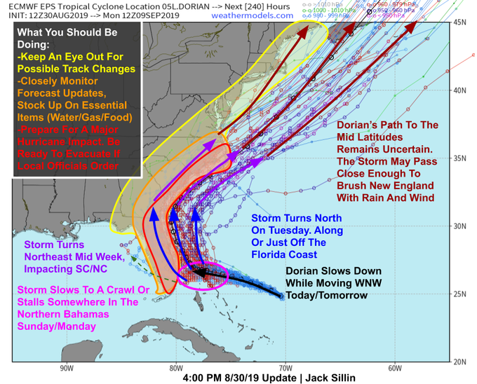
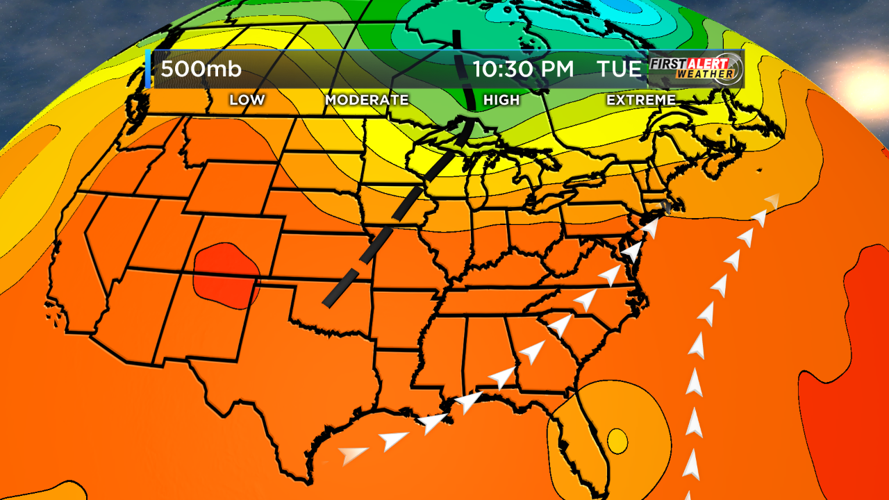
The EURO as shown has pushed Dorian much farther east. The GFS is trending that way as well. If you look at the graphic below you will also see a major shift eastward with all the Ensemble members. This makes since because the forward speed for Dorian is expected to slow down a good bit. The slower it moves the better the chances this thing skirts the coast or stays out to sea. The next graphic shows the EURO's 500mb heights. There is a weakness across the southeast that would allow the mid level trough to pick Dorian up and shoot her out to the northeast. 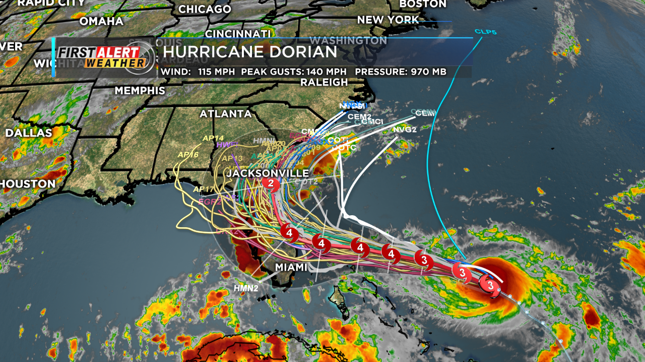
Thanks Grant,
I've thinking about the statements made earlier about more damage occurring on the right side vs left side of hurricanes as it applies to Dorian.
The faster the forward speed of a hurricane, the more this principal adds or subtracts to/from wind speeds caused by just the circulation.
With Dorian expected to crawl forward early next week, this will not be a factor as it is for some hurricanes.........like Michael for instance.
Michael was going at something like 12-15 mph when it hit the Panhandle, so the area immediately to the right, like Mexico Beach gained up to 15 mph in wind velocities to the wind.
Then Michael's speed accelerated as it raced northeast in GA. So while it weakened and circulating winds dropped, it was gaining wind speed on the right side from the entities increasing speed. As a result, winds remained very strong, hurricane force well into GA with gusts above hurricane speeds, several hundred miles inland, even after it wasn't a hurricane anymore.
https://www.teamcomplete.com/hurricane-michael/
Michael's winds below:
If that through can pick her up and accelerate Dorian to the northeast, as you say the forward speed would subtract the wind impact on the left side saving the coast a bit. However, if it hugs the coast there would be significant storm surge all along the path even with lower wind impact. It is now a Cat 4!
WOW! That's 20 mph stronger than the previous forecast was calling for this early on:
Hurricane Dorian Tropical Cyclone Update NWS National Hurricane Center Miami FL       AL052019 830 PM EDT Fri Aug 30 2019
...DORIAN STRENGTHENS TO A CATEGORY 4 HURRICANE...
Data from the NOAA Hurricane Hunters indicate that Dorian has strengthened to an extremely dangerous category 4 hurricane with maximum sustained winds near 130 mph (215 km/h). This increase in intensity will be reflected in the forecast issued at 1100 pm EDT (0300 UTC).
I was thinking too about if Dorian completely stalls or just drifts very slowly. It would churn up some cooler water from below which could actually weaken it off the Southeast Coast of FL on Monday.
I'll try to find some sea surface temps that go down below the surface to see what the depth is of the 27 deg. C water.
I think a completely stalled hurricane would have limited "peak" growth potential because of the cooler waters below coming up.
Dorian updates continue with the farther right/east track of the last 24 hours, now keeping the storm OFF the FL coast as it tracks north, never making landfall. Still slow forward speed and maintaining much of its strength but with it being a small hurricane, it could stay far enough off the coast to minimize the higher end impacts on Florida that a major hurricane can have on areas in its direct path!
Dorian is up to 150 mph with the NHC peaking it at 155 mph later today. They have shifted the track a tad to the right/east again and on the current path, Florida would be spared as the major hurricane passes far enough off the coast so that major hurricane impacts would not be felt anywhere in the Sunshine state. The guidance has consistently favored this turn farther east.............until this last run of the US model that just came out after this latest NHC update. It's just a smidgen farther to the left this time and a tiny bit closer to the coast. Each run will not be the same and changes like this can be expected and its still farther east/right of the track 24 hours ago but it shows that there is still potential for Hurricane Dorian to go back towards Florida which is no way out of the hurricane woods.
https://www.nhc.noaa.gov/graphics_at5.shtml?key_messages
GFS ensembles also were a smidgen farther west of 6 hours ago but still well east of the runs prior to that and far enough off the coast to barely spare FL(again, the track will continue to change and can head back west again).
Last European model is slightly east/farther off the coast than its previous run, which continues to reduce the threat to Florida a bit but the Sunshine state is still not close to being home free.
4:20p CDT: No changes by the NHC in track or intensity which makes sense based on the previous model run changes being small and in opposite directions. Each update that does not turn it back west decreases the chances that this will happen and solidifies confidence a tiny bit more. However, even if there was just a 5% chance of Dorian slamming into FL as a cat. 4 hurricane(not saying that odds are that low, because they are higher than 5% that but just hypothetically), that's still significantly high because of the catastrophic damage it will cause and hurricane forecasts in the past have deviated by much greater distances for this time frame than this one would need to for that to happen.
6:10pm CDT
The GFS products have shifted the track of the hurricane even more westward than the minuscule shift west of the previous run(The previous European model that was bit farther east will not be updated for another 8 hours-only 2 times daily vs 4 times daily for the GFS).
This puts Dorian's hurricane force winds on the left side almost on the coast again, even though the center is still off the coast. This should be no surprise. There will be additional shifts ahead.
One slight positive element that I've mentioned is that a hurricane going north like this, along the East Coast, will always have the speed of its movement ADDED on the right side of its path(which will also have winds in the same direction-south to north) and SUBTRACTED on the left/west side because winds around the entity will be in the opposite, north to south direction.
Since a hurricane tracking along the coast, by definition will have the entire US to its west/left, whatever speed its moving at will reduce wind speed over the terrain by that amount(as long as its movement is parallel to the Coast).
If top winds are blowing at 120 mph and traveling North at 5 mph, that takes it down to 115 mph and all the other winds on that west side will be reduced by 5 mph. When it picks up speed with time, the wind reduction will be even greater(reality is that friction from land will probably reduce wind speeds even more of the west side)
Winds on the other side of the hurricane will be potentially +5 mph at 125 mph(the reality is that with less friction from land on that east side, the differential will be even greater between the right/east and left/west side).
Bottom line is that a hurricane moving up the east coast of Florida has a bit less potential than one hitting the west coast of Florida or the Gulf Coast because hurricanes in the Gulf have a right side that encounters land instead of that right/front side staying out to sea in the Atlantic.
https://en.wikipedia.org/wiki/Tropical_cyclone_windspeed_climatology
The storm below is moving northwest at 10 mph. WInds on the southwest (left) side are -10mph and on the northeast (right) side they are +10mph.

NHC update had not changes. It was already west of the guidance, closer to the coast of Florida, so the shift west in the GFS, meant the GFS lined up closer to the NHC track. Since their update, another run of the GFS has come out and it's a smidgen farther east again compared to the previous run but still west of the run 12 hours ago and a tad slower.
72 hours from now, Dorian still hasn't passed the latitude of Jacksonville and is just off the coast with the outer fringes of hurricane force winds possibly on the beaches.
In 96 hours, it's to the GA/SC border with hurricane force winds a bit inland.
In 120 hours( 5 days) it's just off the coast of northeast NC.....hurricane force winds a bit inland.
The European model shifted west overnight and has resulted in the NHC shifting the forecast west closer to the coast, The US model just updated was a tad farther west and close to the European model. The new track is still off the coast but hurricane force winds would be likely along the coast.
The NHC peaks the hurricane at 155 mph today then slowly weakens it but maintains muc of its strength. In 48 hours it stalls out off the SE Florida coast for 12+ hours, then turns north and tracks parallel to the coast, off the coast for a couple of days.
Interaction with land on its left side could effect future intensity.
Dorian up to 180 mph, stronger than previous forecast for today(strongest hurricane ever for that region........NW Bahamas). NHC has it weakening from here. Down to 140 mph in 48 hours, then 110mph in 72 hours.
If it stalls long enough off the Southeast Coast of FL for a while tomorrow, it could churn up some cooler water below and weaken it?
The NHC track was a few miles farther west but still off the coast. This last updated GFS that came out since then was a tad farther east but nothing significant. Every model run that does not shift it farther west will be good news but there is still plenty of time for that to happen.
Noon CDT update: GFS ensembles were farther east, maybe 25 miles? off the FL coast.
https://www.nhc.noaa.gov/graphics_at5.shtml?key_messages
| Home Public Adv Fcst Adv Discussion Wind Probs Graphics Archive U.S. Watch/Warning Local Products |
| Wind Speed Probabilities | Arrival Time of Winds | Wind History | Warnings/Cone Interactive Map | Warnings/Cone Static Images | Warnings and Surface Wind |
Key Messages | Storm Surge Watch/Warning | U.S. Rainfall Potential |
![[Key Messages]](https://www.nhc.noaa.gov/storm_graphics/AT05/refresh/AL052019_key_messages+png/155815_key_messages_sm.png)
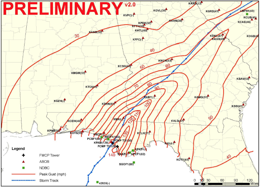
Catastrophic Category 5 Hurricane Dorian made landfall in Elbow Cay in The Bahamas at 12:40 pm EDT Sunday with 185 mph winds, gusting to 220 mph, making it the strongest landfalling Atlantic hurricane on record. In the 8-hour period ending at 12:45 pm EDT Sunday, Dorian put on a rare show of rapid intensification—its already-formidable 150 mph winds increased to 185 mph, and the central pressure dropped from 934 to 911 mb.
Dorian’s forward speed of 8 mph this morning is expected to slow to just 4 mph tonight, causing an unprecedented long-duration battering of The Bahamas by one of the most extreme hurricanes in history. On Great Abaco and Little Abaco islands, hurricane-force winds will likely blow for 12 - 15 consecutive hours, interrupted only by the passage of the calm eye. For several hours, Category 5 winds in excess of 160 mph are likely, which will be capable of destroying all but the most rigorously designed concrete steel-reinforced structures. Dorian may wobble enough to the northwest to prevent Grand Bahama Island from receiving such a long pounding, but that island is still likely to experience extreme damage.
metmike: Just out European model slightly farther east. Florida still not out of the woods though.
From the 1-hourly data (ECMWF), and using small dots, you can see the wobbles of Dorian's track as it makes the consequential turn to the North. This model is typically the most reliable -- and hopefully is the truth to spare Florida from direct landfall effects.
I can’t imagine what Abacos will look like. Thankfully it is a compact storm so that should help Florida but I still see the possibility of significant storm surge along the coast. The winds around the circulation should funnel water into the Jacksonville area as it moves north.
That makes sense with the east winds ahead of the storm as it tracks north, piling up the water from the ocean towards the beaches.
The just updated NHC forecast has stayed about the same. The current winds are still at 185 mph. Here's the intensity forecast at this time on Mon=165mph, Tue =145 Wed =120 Thur= 105
Dorian, at 185mph is up near the top of the strongest winds.
| mph | km/h | |||||
|---|---|---|---|---|---|---|
| Rank | Hurricane | Season | Winds | |||
| Highest 1-minute sustained winds (175 mph or greater)(#* = System Is Ongoing) | ||||||
| 1 | Allen | 1980 | 190 | 305 | ||
| 2 | "Labor Day" | 1935 | 185 | 295 | ||
| Gilbert | 1988 | |||||
| Wilma | 2005 | |||||
| Dorian#* | 2019 | |||||
| 6 | Mitch | 1998 | 180 | 285 | ||
| Rita | 2005 | |||||
| Irma | 2017 | |||||
| 9 | "Cuba" | 1932 | 175 | 280 | ||
| Janet | 1955 | |||||
| Carla | 1961 | |||||
| Camille | 1969 | |||||
| Anita | 1977 | |||||
| David | 1979 | |||||
| Andrew | 1992 | |||||
| Katrina | 2005 | |||||
| Dean | 2007 | |||||
| Felix | ||||||
| Maria | 2017 | |||||
NHC forecast unchanged. With Dorian just off the coast.
However, the just out GFS ensembles shift Dorian slightly farther west and have the center almost on the coast with the left side of the eyewall(where some of the highest winds will be) on the coast.
The highest winds will be the right side that will be out in the Atlantic as Dorian moves northward, parallel to the coast.
Dorian following close to the forecast. Stalled and down to 165 mph right now. Should continue to weaken then head up the coast but just off the coast as a major hurricane still later today.
Oj market will open sharply lower on Tuesday as the remainder of the hurricane risk premium that came out Friday comes out,
The last update continues with Dorian almost stalled (just today) as was predicted and the NHC mentioning upwelling because of the slow movement as a potential to weaken it a bit in the near term(churning of ocean waters below to pull up cooler waters at depth, to the surface), which is what I mentioned late last week. Not that it will for sure, just possible.
Regardless, the intensity of the highest winds will slowly drop even as the size of the circulation expands, so the fringe areas actually get wider.
Also, the last model run forecasts clearly shifted around 25 miles farther west with the center, which, from eyeballing the maps, to me looks like hurricane force winds could be felt on the coast of Florida.
10:45 am update: The new GFS operational model is just in and it goes back east/right of the previous run, by maybe 25-30 miles? keeping Dorian farther away from the coast.
Another slight change. The intensity on this model run is stronger off the Southeast coasts in a couple of days because of this shift and a bit less interaction with land.
Things are still far from certain but the magnitude of potential surprises dimininshes when the time frame shrinks(of instance, we can say with high confidence that Dorian will not cross west into the state of FL)
Noon: GFS ensembles similar to operational model above. Dorian is stronger in the Southeast/Carolina Coasts but that can change.
4PM: No changes. Top winds down to145 mph, more weakening on the way but Dorians size will increase a bit at the same time.
5PM: Just out GFS has Dorian farther east by another 25 miles(guess) or so ,about the farthest east of any solution the past couple of days. Though it grows wider/bigger(like before-with max speeds dropping at the same time). So the hurricane force winds are off the coast but tropical force winds on the coast. A slight shift west again will change that.
Since the huge shift right/north on Friday Morning, the model changes and consistency from run to run have been excellent for a hurricane over a 3 day period.
11PM: No changes. Top winds are130 mph currently.
Dorian is on the move north again after stalling for a day.
Top winds have continued to fall, down to 110, a strong cat. 2. Churning up cooler water from sitting in the same spot probably helped weaken it.......but it's moving over less disturbed(as deeply) water now and is expected to at least maintain this strength and grow in size with high confidence.
The entire Florida East Coast will have tropical force winds but those will not penetrate very far inland. Again, at this point with the hurricane moving north and parallel to the coast, places on the west/left side will see the speed of its movement, taken away from the winds rotating around the entity.
When Dorian approaches the Southeast Coasts from a more perpendicular angle, this principle will shift and the speed of its movement will become more neutral to possibly adding to the winds in some locations(that are on its right side when it approaches-those spots that jut out farther east into the Atlantic)
Bottom line: 110 mph with an expansion of hurricane force winds, so more dangerous when it approaches the Carolina's. on Thursday.
The last, just updated GFS does not show much deviation from the previous one.
Looking at the latest models, I'm more concerned now for the Southeast Coasts, starting very early on Thursday. It looks like they may get hammered.
The hurricane is now moving north, away from the churned up waters that were gradually killing it, so as it tracks into fresher/warmer surface water, it will likely stop weakening and in fact, is likely to expand the circulation of hurricane force winds(even if the top winds stay where they are now at 110 mph).
Everything is fine until Dorian gets to the latitude of Georgia(where the coasts recede westward and lessen the risk initially).
However, when it gets to the latitude of northeast GA, around Savannah, the coast start jutting out more and more in the east direction, with the land mass really sticking out much farther and farther east in South/North Carolina.
Based on the latest guidance, at the very least, this means the recipe for the center of the hurricane to get extremely close to the coast and good chance for hurricane force winds along the coast.
Another dynamic will reverse, at least in part. At this time, the entire coastline is on the left/west side of the hurricane and the speed of the entire entity takes away from the counterclockwise winds(on just that side). The right side facing the ocean has that speed added to the winds.
As long as Dorian moves parallel to the coast, this principle remains beneficial.
When the coast starts sticking way out in SC/NC, the movement will not be as parallel to the coast anymore(unless the hurricane track also shifts strongly to the east and it remains the same distance off the coast as before.
However, any closing of the gap between the hurricane and coast, means there is perpendicular movement and the benefits of moving parallel will be diminished. If the hurricane would move father left and close that gap fast, it's traveling entity speed could actually add to the speed of the winds on its right side as it approaches then hits the coasts in SC/NC.
In 48 hours, top winds circulating around the hurricane will start weakening but still at 105 mph.
However, it's forward speed will be starting to accelerate. So there may be a small window of time when 3 things coincide to maximize the winds along the SC/NC coast.
1. The intensity remains high, still over warm waters and a favorable environment
2. It moves perpendicular to the SC/NC coast and entity speed adds to circulation speed on the right/front side.
3. Dorian starts accelerating its forward entity speed(while the other 2 elements above are happening, so that the contribution of entity speed goes up quickly........let's say to 15-20 mph.
The one element that lessens 2 and 3 happening simultaneously is that when it accelerates forward speed, the easterly component in its movement may also increase..............which means NOT moving perpendicular to and towards the coast at the same time.......if it does accelerate but move more easterly
No great changes but it looks likely, that hurricane force winds will pound the coasts, starting from northeast Georgia, then extending northeast to all of coastal SC, then NC.
This will start as early as midnight Wednesday Night, just south of Savannah GA and continue all day on Thursday as Dorian tracks right along the coast.
The center of the hurricane stays just off the coast but the expanding circulation over the next 24 hours will allow hurricane force winds to extend well outside of the center.
No big changes to the previous couple of summaries. Dorian's top winds are at 105 mph and expected to remain close to that the next 2 days. Models have been incredibly consistent showing the same solutions for quite awhile.
Dorian will be getting closer to the coast or should we say, the coast will be getting closer to Dorian's northbound track tonight and Thursday because the coast juts out, eastward into the Atlantic, starting from Northeast GA, and especially over SC/NC.
These are the area's likely to experience hurricane conditions.
Should Dorian take a track farther left/west and make landfall, initially that location and just to the right of it will experience the worst conditions of any location in the US for this entire event.
After that, the interaction with land will weaken Dorian a bit but enough circulation will remain over water so that it still remains dangerous. However, after 48 hours, Dorian should encounter more wind shear and drier air as it accelerate northeast as it makes the transition to an extratropical storm in the Atlantic.
Dorian was back up a bit to 110 mph on the earlier update, so as expected, it's not going to weaken and will be getting closer to the coast. I continue to be concerned about the exact same areas described above, over the last 2 days for Thursday.
Never in my life did I ever think that I would be covering something like this when dealing with a hurricane.
Trump is correct on Hurricane/Alabama-here's proof
Started by metmike - Sept. 4, 2019, 8:25 p.m.
https://www.marketforum.com/forum/topic/38379/
I guess when you can make up all sorts of things about a fake climate crisis for 2 decades, nothing should be surprising anymore )-:
3KM NAM really strengthens this storm again off the SC Coast. I think it is over done as more shear will begin to be encountered. I think it could hit 115MPH again before weakening as it moves towards the outer banks. All models seem to have a similar path with the Canadian the closest to shore. The concave coastline north of Myrtle Beach and near Wilmington will likely funnel in more storm surge in those areas until the storm passes just off to the northeast.
Thanks Grant!
Yes, Dorian is in fact back up to 115 mph as of this last update from the NHC.
No real change to the intensity or track.
The coasts of SC/NC really get clobbered the next 24 hours as Dorian gets closer to the coast but stays barely off the coast.
This thread is record length...........sorry for all the scrolling needed to get down here:
https://www.nhc.noaa.gov/graphics_at5.shtml?start#contents
| Home Public Adv Fcst Adv Discussion Wind Probs Graphics Archive U.S. Watch/Warning Local Products |
![[Key Messages]](https://www.nhc.noaa.gov/storm_graphics/AT05/refresh/AL052019_key_messages+png/034215_key_messages_sm.png)
Dorian, as predicted has continued closer to the coast of SC this morning. The edge of the eye wall(which has the highest winds) is now along the edge of the coast. The hurricane is starting to weaken, down to 110 mph top sustained winds but will remain at 100+ mph into tonight while it batters the SC, then NC coasts and points just inland.
The Virginia Beach area in far southeast VA may get hit with hurricane force winds on Friday before Dorian accelerates northeastward, out into the Atlantic late on Friday.
Lots of circulations in the rain bands moving on shore. It will be interesting to see how many tornadoes this system produces.
Thanks Grant!
Here's a radar loop that shows the exact location of Dorian and counterclockwise bands whipping around the center........and the still identifiable eye pretty close to the North Carolina Coast(edge of the eyewall is around Cape Fear NC). Dorian is moving N/NE at 10mph with top winds at 100 mph. Winds on the right side of the hurricane in the eye wall, right on the coast because of the increasing forward speed may be able to gust above 100 mph.
11pm Thursday: Top sustained winds 100mph but slowly weakening. Speed of Dorian picking up, now at 13 mph, headed northeast.
https://radar.weather.gov/Conus/southeast_loop.php

https://www.spc.noaa.gov/products/md/md1933.html
| Mesoscale Discussion 1933 | |
| < Previous MD | |
 | |
Mesoscale Discussion 1933 NWS Storm Prediction Center Norman OK 0731 PM CDT Thu Sep 05 2019 Areas affected...Eastern NC...Far Southeastern VA Concerning...Tornado Watch 637... Valid 060031Z - 060230Z The severe weather threat for Tornado Watch 637 continues. SUMMARY...Threat for brief tornadoes continues across eastern NC and far southeastern VA. DISCUSSION...Based on recent radar imagery, the center of Hurricane Dorian appears to be about 60 miles south of Wilmington, NC. Two well-defined rain bands exist, one about 125 miles from the center and the other about 160 miles. The southern band currently extends from Craven County NC southeastward offshore while the northern band extends from Martin County NC southeastward offshore. Lightning and a few transient circulations have been noted within the northern band. As of 0025Z, only a few lightning strikes have been noted within the southern band. Both of these bands are expected to gradually move northward over the next several hours. Any tornado potential over the next two hours will likely occur within these bands as cells sporadically deepen. | |
Dorian has now become an extratropical hurricane force storm. Winds are still at 100 mph.
Dorian will be clobbering Novia Scotia and other eastern portions of Canada the next 36 hours while weakening down to around 60 mph. Since Dorian is racing northeast at 31 mph, winds on the right side of the storm could gust to 30 mph higher than the circulation but the right side of the storm is mostly facing towards the ocean.