Weather models are turning sharply colder late in week 2. Cold enough for a freeze in the Upper Midwest, at least on the operational US model, which so far has been an outlier.
Some of the more extreme solutions(operational US model mainly) would take the below freezing temps farther south.
This would especially hurt some of the late planted beans if the Eastern Cornbelt would get hit with a freeze.
However, corn that is not in the dough state as of Monday would suffer some yield loss(if it were a hard freeze) and beans not setting pods yet as of Monday would be hurt bad.
https://release.nass.usda.gov/reports/prog3719.txt
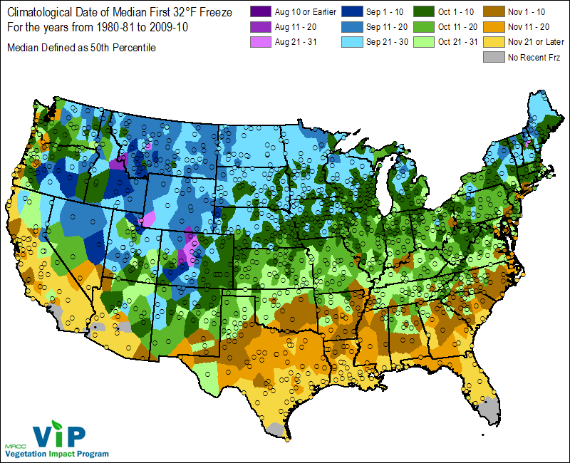
The freeze risk period looks to start just beyond the dates on this map below, basically in 2 weeks. This product is from all the GFS ensemble solutions(which often do a better job than the operational model-which can get too extreme at times-possibly now) Thanks again to Grant for the link to get these awesome analog maps below.
http://www.eas.slu.edu/CIPS/ANALOG/EXT_DFHR1.php?fhr=F312&rundt=2019091100&map=NMINT032
Analog Run: GEFS 20190911/0000F312
To see the domains used to find these analogs click here.
Percentage: < 30%
Contours

Previous posts on Freezes:
Damaging Midwest Freezes the last 50 years
17 responses |
Started by metmike - Aug. 7, 2019, 5:33 p.m.
https://www.marketforum.com/forum/topic/36333/
Frost/corn development
18 responses |
Started by wglassfo - Aug. 26, 2019, 8:53 p.m.
This is a great resource!
This is what the last operational US model showed. The 0 deg. C 850 mb isotherm is south of Chicago!
This is a huge outlier at the moment.

These would be low level/2 meter temperatures early on Sept 27th compared to average.
Actual temperatures that morning. Below freezing into Northeast IA/N.IL. Again, this is a huge outlier and probably won't look this cold tomorrow.....but if it does and other models follow, the market will start adding more freeze damage risk premium
eric Snodgrass is out with his frost/freeze outlook in his latest video. he has had some good stuff all summer
Can you pass that along for us please mcfarm?
Eric Snodgrass 9-12-2019
Try this mike
Edit
https://www.youtube.com/watch?time_continue=40&v=VYxEcrkcRvQ
That link won't work cutworm, do you have another one?
Erick Snodgrass long range forecast 9-11-2019
Thanks very much cutworm and mcfarm. I've never heard anybody do a better job than Erick........and he provides so much unique stuff that has great meaning to understanding pattern recognition.
Latest guidance has no freeze threat. The sometimes(on a handful of runs this week), extremely chilly operational US model just updated looks like most of the other guidance that keeps the cold locked up in northern Canada.
September 26-29 below. Freeze watch is back on.
Analog Run: GEFS 20190915/0000F312
Percentage: < 30% Contours

Now you have me interested!
Latest guidance?
The GFS operational model has a freeze for days 13-15 on the last run that finished just over 3 hours ago but, once again, its a comple outlier and has shown this solution more than half a dozen times over the last week or so, then it vanishes on the next couple of runs..........which is why its defined as an outlier.
The other models don't have this.
The next run will start in less than 2 hours and end in 3 hours.
I have not bought this outlier run but it possible for sure.
Thank you for generously updating the freeze watch AND weather daily.
TRULY hope you get to buy a change in forecast! LOL
YW tjc!
What are your thoughts today?
Looking for interim high in soyas and corn tu/wed. Then a correction into next Monday.
OF COURSE, confirmation of a possible freeze could be the trigger for this high with a subsequent selloff.
Option EXPIRATION on Friday
A "favorable" crop condition could also be the 'news' event for this suggested high, but it would be considerably less dramatic!
There's a chance the bean condition could drop a couple of points this afternoon from extremely heavy rains north, and hot/dry south.
I can't recall crop ratings mattering anymore this late in the year but the crop is far enough behind that this year could be an exception.
The bean harvest usually puts tremendous pressure on prices in late Sept/early Oct.
9-27 to 9-30 period below. No freeze threat at the moment.
The cold is farther west with a huge upper level ridge in the East blocking it. A shift eastward would bring the freeze threat back.
Percentage: < 30% Contours

This are the risk maps for a freeze for days 9-11 and days 12-14 below that. You can see that the main blob of cold is northwest of the belt.........then passes north of it because of the blocking heat ridge in the Southeast.
The last operational US model dumps the cold in big time, starting early day 9 and would cause some potentially below freezing temps on days 10-11, followed by an even colder air mass a couple of days after that..........but its an outlier again and has shown this too cold solution numerous times this month.
The other thing is that we are talking an early October time frame. For the northern locations this is actually a bit late for the first freeze. Damage at this point is not going to be great or unusual, even with the crop so late.


