Weather Monday
16 responses | 0 likes
Started by metmike - Oct. 14, 2019, 10:51 a.m.

Hello October 14th!  Do something......(say hello to a stranger) to make somebody feel especially lucky today......... Then think about how lucky you are to be living in this era of plenty in human history!

 Scroll down and  enjoy the latest comprehensive weather to the max...... occurring because of the natural physical laws in our atmosphere as life on this greening planet continues to enjoy the best weather/climate in at least 1,000 years(the last time that it was this warm).


Here are the latest hazards across the country.


Purple/Pink/blue on land is cold/Winter weather. Brown is wind,  Green is flooding. Gray is fog.  Reddish is a red flag advisory.  

Go to the link below, then hit the location/county on the map for details.

                          https://www.spc.noaa.gov/  Go to "hazards"                                                                                     


 Current Weather Map


NCEP Days 0-7 Forecast Loop
NCEP Short-Range Model Discussion
NCEP Day 3-7 Discussion


Understanding These Maps
Surface Map Legend
Precip Legend
NCEP Surface Maps
(Mouseover)

U.S. Surface Analysis
National Radar Image
12-Hr Forecast
24-Hr Forecast
36-Hr Forecast
48-Hr Forecast
Short Term Loop
Day 3 Forecast
Day 4 Forecast
Day 5 Forecast
Day 6 Forecast
Day 7 Forecast
Low Tracks Error Circle
Low Tracks Ensemble


US Weather Current Temperatures Map


US Weather Current Temperatures Map

US Weather Heat Index Map

      Wind map     Press down on this on the left with your cursor!

Legend


Current Jet Stream


Low Temperatures Tomorrow Morning


Highs today and tomorrow.


Comments
By metmike - Oct. 14, 2019, 10:52 a.m.
Like Reply

Highs for days 3-7:


Temperatures warming up!  


http://www.wpc.ncep.noaa.gov/medr/DAY3_MAX_filled.gif

https://www.wpc.ncep.noaa.gov/medr/DAY4_MAX_filled.gif

http://www.wpc.ncep.noaa.gov/medr/DAY5_MAX_filled.gifhttp://www.wpc.ncep.noaa.gov/medr/DAY6_MAX_filled.gif


https://www.wpc.ncep.noaa.gov/medr/DAY7_MAX_filled.gif


By metmike - Oct. 14, 2019, 10:53 a.m.
Like Reply

Cold moderates.


https://www.wpc.ncep.noaa.gov/medr/medr_mean.shtml


http://www.wpc.ncep.noaa.gov/medr/hpcmaxwbg.gif


https://www.wpc.ncep.noaa.gov/medr/95Bwbg.gif


By metmike - Oct. 14, 2019, 10:54 a.m.
Like Reply

Weather maps for days 3-7 below


Quiet, then new storm this weekend.

https://www.wpc.ncep.noaa.gov/medr/5dayfcst_wbg_conus.gif


By metmike - Oct. 14, 2019, 10:56 a.m.
Like Reply

Liquid equivalent precip forecasts for the next 7 days are below.


Rains increase a great deal this coming weekend.


Day 1 below:

http://www.wpc.ncep.noaa.gov/qpf/fill_94qwbg.gif?1526306199054

http://www.wpc.ncep.noaa.gov/qpf/fill_94qwbg.gif?1531339983148

Day 2 below:

http://www.wpc.ncep.noaa.gov/qpf/fill_98qwbg.gif?1528293750112


http://www.wpc.ncep.noaa.gov/qpf/fill_98qwbg.gif?1531340045174


Day 3 below

http://www.wpc.ncep.noaa.gov/qpf/fill_99qwbg.gif?1528293842764

http://www.wpc.ncep.noaa.gov/qpf/fill_99qwbg.gif?1531340092706


Days 4-5 below:

http://www.wpc.ncep.noaa.gov/qpf/95ep48iwbg_fill.gif?1526306162

http://www.wpc.ncep.noaa.gov/qpf/95ep48iwbg_fill.gif?1531339379

 Days 6-7 below:

http://www.wpc.ncep.noaa.gov/qpf/97ep48iwbg_fill.gif?1526306162

http://www.wpc.ncep.noaa.gov/qpf/97ep48iwbg_fill.gif?1531339379

7 Day Total precipitation below:

https://www.wpc.ncep.noaa.gov/qpf/p168i.gif?1566925971
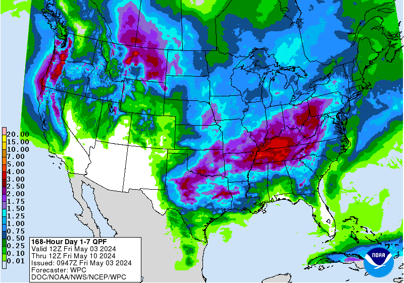

https://www.wpc.ncep.noaa.gov/qpf/p168i.gif?1566925971


By metmike - Oct. 14, 2019, 10:56 a.m.
Like Reply

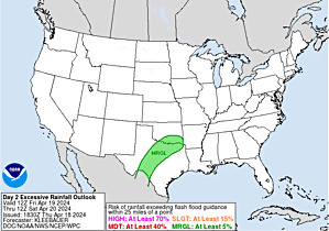
Excessive rain potential-south


Mesoscale Precipitation Discussions


Current Day 1 ForecastCurrent Day 1 Excessive Rainfall Forecast
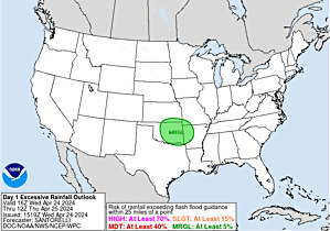
Valid 16Z 08/30/19 - 12Z 08/31/19


Day 1 Threat Area in Text Format  


  Day 2 and Day 3 Forecasts 
Current Day 2 ForecastCurrent Day 2 Excessive Rainfall Forecast
Valid 12Z 08/31/19 - 12Z 09/01/19


Day 2 Threat Area in Text Format 


Current Day 3 ForecastCurrent Day 3 Excessive Rainfall Forecast
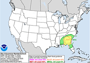


By metmike - Oct. 14, 2019, 10:57 a.m.
Like Reply

Severe Storm Risk the next 8 days:


Current Day 1 Outlook
        1300 UTC Day 1 Outlook             
                Forecaster: Grams/Leitman
Issued: 30/1238Z
Valid: 30/1300Z - 31/1200Z
Forecast Risk of Severe Storms: Marginal Risk        
      
          Current Day 2 Outlook
          0600 UTC Day 2 Outlook               
                Forecaster: Mosier
Issued: 30/0537Z
Valid: 31/1200Z - 01/1200Z
Forecast Risk of Severe Storms: No Svr Tstms        
      
          Current Day 3 Outlook
          0600 UTC Day 3 Outlook               
                Forecaster: Mosier
Issued: 30/0725Z
Valid: 01/1200Z - 02/1200Z
Forecast Risk of Severe Storms: No Svr Tstms
      
          Current Day 4-8 Outlook
          Day 4-8 Convective Outlook


By metmike - Oct. 14, 2019, 10:59 a.m.
Like Reply

Last 24 hour precip top map

Last 7 day precip below that

https://www.wunderground.com/maps/precipitation/daily

CA - BakersfieldNY - BinghamtonND - BismarckNH - BerlinTX - BrownsvilleKY - Bowling GreenMI - CadillacNC - CharlotteGA - ColumbusOH - DaytonCO - DenverIA - Des MoinesFL - Key WestVA - RoanokeCT - HartfordMO - Jefferson CityOK - LawtonNE - North PlatteAR - Little RockMT - LewistownLA - New OrleansID - McCallFL - Saint PetersburgSD - PierreAZ - PrescottUT - ProvoOR - RedmondWY - RivertonNV - RenoNM - RoswellTX - San AntonioVA - StauntonKS - SalinaIL - SpringfieldMN - Saint CloudWA - TacomaMS - Vicksburg

CA - BakersfieldNY - BinghamtonND - BismarckNH - BerlinTX - BrownsvilleKY - Bowling GreenMI - CadillacNC - CharlotteGA - ColumbusOH - DaytonCO - DenverIA - Des MoinesFL - Key WestVA - RoanokeCT - HartfordMO - Jefferson CityOK - LawtonNE - North PlatteAR - Little RockMT - LewistownLA - New OrleansID - McCallFL - Saint PetersburgSD - PierreAZ - PrescottUT - ProvoOR - RedmondWY - RivertonNV - RenoNM - RoswellTX - San AntonioVA - StauntonKS - SalinaIL - SpringfieldMN - Saint CloudWA - TacomaMS - Vicksburg


By metmike - Oct. 14, 2019, 11:01 a.m.
Like Reply

Current Dew Points


Current Dew Points


Latest radar loop


http://www.nws.noaa.gov/radar_tab.php

Doppler Radar National Mosaic Loop


Upper Mississippi Valley sector loop


 (3400x1700 pixels - 2.2mb)
Go to: Most Recent Image


Central Great Lakes sector loop
Go to: Most Recent Image


    You can go to this link to see precipitation totals from recent time periods:


https://water.weather.gov/precip/


                              Go to precipitation, then scroll down to pick a time frame. Hit states to get the borders to see locations better. Under products, you can hit "observed" or "Percent of normal"      

+++++++++++++++++++++++++++++++++++++++++++++++


Precipitation compared to average for the last 7, 14, 30 and 60 days. 

Some spots in Iowa and especially N/C Illinois have dried out!


Usually not updated for previous day until late the next day.

https://www.atmos.illinois.edu/~snodgrss/Ag_Wx.html

http://weather.agribleservices.com/ahps/7_day_percent.png

By metmike - Oct. 14, 2019, 11:01 a.m.
Like Reply

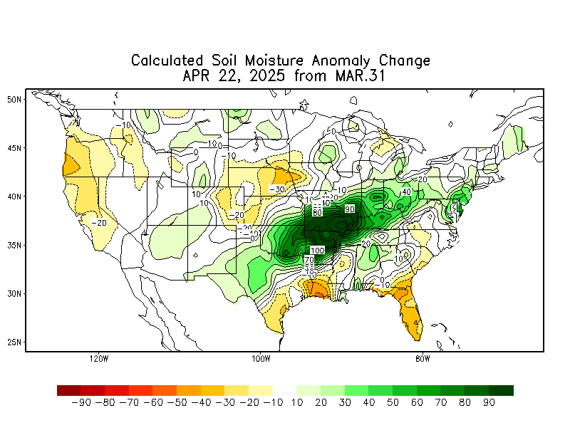
Soilmoisture anomaly:

These maps sometimes take a day to catch up to incorporate the latest data(the bottom map is only updated once a week).


https://www.cpc.ncep.noaa.gov/products/Soilmst_Monitoring/US/Soilmst/Soilmst.shtml#
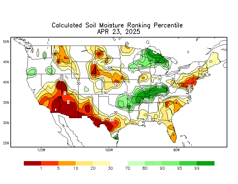
                            

Daily Soil Moisture Pecentile       

        Daily Anomaly Soil Moisture (mm)

        Monthly Soil Moisture Change

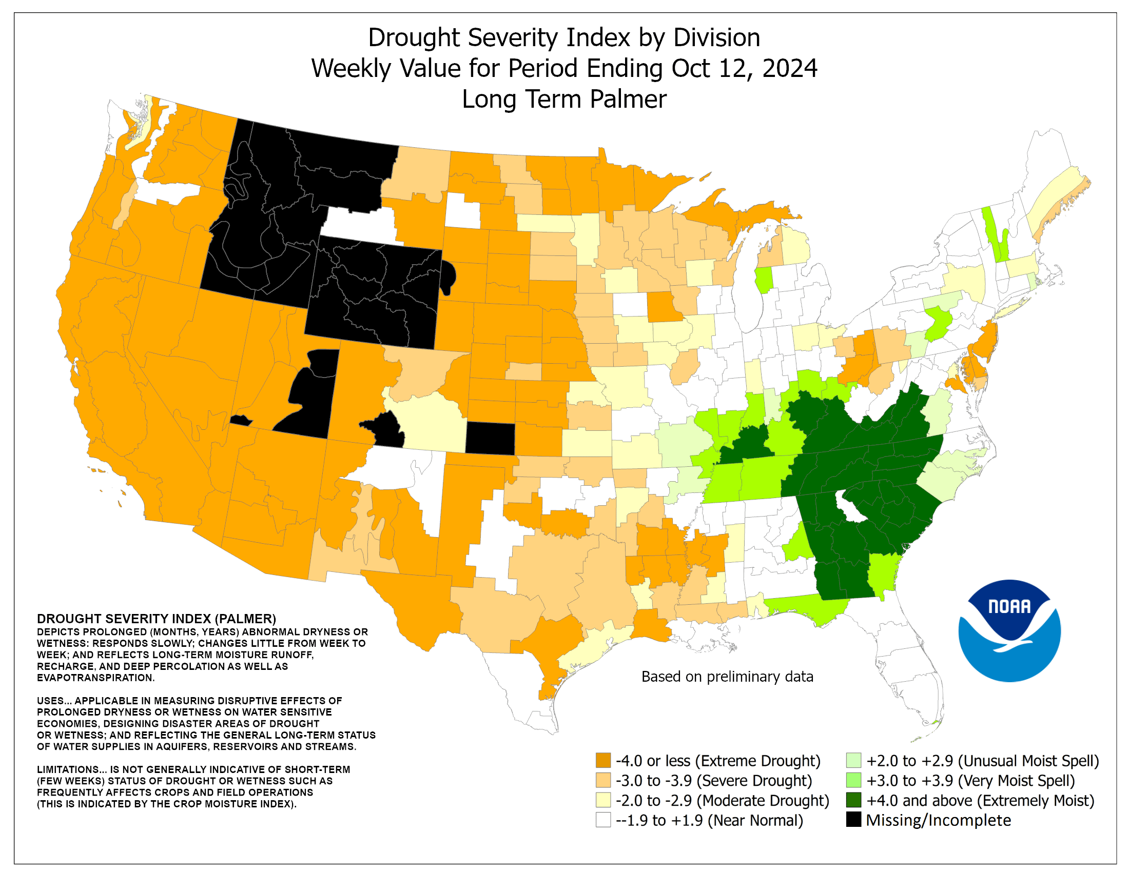
https://www.cpc.ncep.noaa.gov/products/analysis_monitoring/regional_monitoring/palmer.gif

https://www.cpc.ncep.noaa.gov/products/analysis_monitoring/regional_monitoring/palmer.gif


By metmike - Oct. 14, 2019, 11:02 a.m.
Like Reply

Latest: The first map below is the latest. The 2nd one is from last week.

In july/August/Sept/Oct, it's typical to see some increase in drought because of  evaporation, seasonally exceeding low rainfall during those months. However, this year saw a HUGE increase in the Southeast!

Oct. 10: TOP MAP SHOWS DROUGHT INCREASED QUITE A BIT IN THE LAST WEEK(AGAIN) in the Southeast.


The map below is updated on Thursdays.


https://droughtmonitor.unl.edu/


Drought Monitor for conus


                 Drought Monitor for conus


By metmike - Oct. 14, 2019, 11:05 a.m.
Like Reply

360h GZ 500 forecast valid on Oct 29, 2019 00 UTC

GZ 500 forecastGZ 500 forecastGZ 500 forecastGZ 500 forecast

Forecasts for the control (GEM 0) and the 20 ensemble members (global model not available)

By metmike - Oct. 14, 2019, 11:06 a.m.
Like Reply

0Z GFS(American model) Ensembles at 2 weeks:

http://mp1.met.psu.edu/~fxg1/ENSHGT_0z/f360.gif


By metmike - Oct. 14, 2019, 11:07 a.m.
Like Reply

GFS Ensemble mean(average of all the individual solutions above).  The first map is a mid/upper level map. The 2nd one is a temperatures map at around 1 mile above the surface. These are anomalies(difference compared to average).

NCEP Ensemble t = 360 hour forecast


NCEP Ensemble t = 360 hour forecast producthttps://www.esrl.noaa.gov/psd/map/images/ens/t850anom_f360_nhbg.gif


By metmike - Oct. 14, 2019, 11:07 a.m.
Like Reply

Latest, updated graph/forecast for AO and NAO here, including an explanation of how to interpret them...............mainly where they stand at the end of 2 weeks.

Previous analysis, with the latest day at the bottom for late week 2 period.


https://www.marketforum.com/forum/t


By metmike - Oct. 14, 2019, 11:07 a.m.
Like Reply

National Weather Service 6-10 day, 8-14 day outlooks.


Temperature Probability


6 to 10 Day Outlook - Temperature Probability Precipitation Probability


  6 to 10 Day Outlook - Precipitation Probability


the 8-14 day outlooks
ArchivesAnalogsLines-Only FormatGIS Data

Temperature Probability

8 to 14 Day Outlook - Temperature Probability
8 to 14 Day Outlook - Precipitation Probability


By metmike - Oct. 14, 2019, 3:56 p.m.
Like Reply

https://www.cpc.ncep.noaa.gov/products/predictions/threats/temp_probhazards_d8_14_contours.png