Note: The posts here were made on Wednesday and the maps here update everyday.
So if you looking at these posts and its Friday, you are getting Wednesdays weather description but the maps updating ever day to the latest maps, will show Friday's weather...........for instance the (current)national radar below. Alberto is long gone but the post was drawing attention to Alberto on Wednesday.
I'll have to figure out a way to do this so the verbiage lines up with the weather.
I think that just starting fresh with new everything, everyday is best.
Radar loop. Note the tiny spiraling bands of rain associated with the remnants of Alberto.......in sw Indiana. It's about as expected and moving northeast.....hopeful into mcfarm-land.
https://radar.weather.gov/Conus/index_loop.php

Go to: Most Recent Image
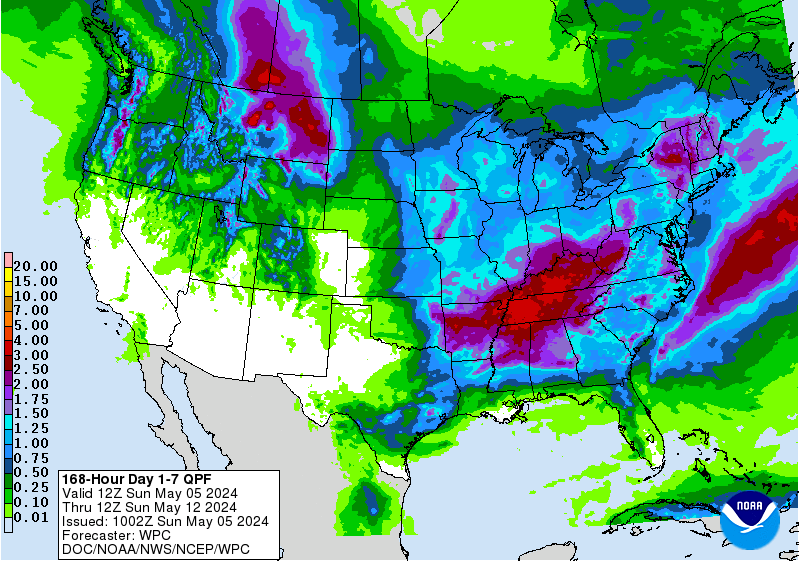
Rain the next 7 days. Lots of it........pressuring grains early this morning:
http://www.wpc.ncep.noaa.gov/qpf/p168i.gif?1527688332
Potential for severe storms the next 3 days. When you have this, there is often a strong jet stream associated with the activity:
http://www.spc.noaa.gov/products/outlook/
| Current Convective Outlooks | |
|---|---|
Current Day 1 Outlook | Forecaster: Edwards/Smith Issued: 30/1251Z Valid: 30/1300Z - 31/1200Z Forecast Risk of Severe Storms: Enhanced Risk |
Current Day 2 Outlook | Forecaster: Dial Issued: 30/0600Z Valid: 31/1200Z - 01/1200Z Forecast Risk of Severe Storms: Slight Risk |
Current Day 3 Outlook | Forecaster: Dial Issued: 30/0730Z Valid: 01/1200Z - 02/1200Z Forecast Risk of Severe Storms: Slight Risk |
Current Day 4-8 Outlook | |
Here is the jet stream:
Forecast Hour: 049
Image URL: http://mag.ncep.noaa.gov/data/gfs/06/namer/200_wnd_ht/gfs_namer_049_200_wnd_ht.gif

I love the maps. Thanks for the update Mike.
Thanks Jim!
My guess on the NWS extended maps later today.
With absolute confidence the heat will be greatest the farther you go west.
There will be an area of below temps, somewhere in the east. How big and far west ?
There will be an area of below rains, especially in the 6-10 day, possible fairly large. Tricky about where to put it.
There will also be an area with below rains in the 8-14 day, highest chances of being dry, going southwest, entering the rain suppressing influence of the dome.
The S.Plains will have blistering heat(100+) and no rain
Thinking that tonights 6-10 and 8-14 day could be more bullish again.
about what we expected out of alberto, the main moisture is swirling to west side while we are stuck on the east...so far got the side walk wet. big circle of moisture just spinning to the west but we will get none of that. friend got 6/10s out of an ordinary rain cloud in Champaign, ill last nite and alberto is still heading his way with more. This is shaping up to be another big miss for much of this area
Sorry to see you are missing this rain mcfarm.
Still the chance of one of the many spiraling bands around Alberto could intensify later today and give you .5 or so.
Am getting just a bit more bullish in the extended at the moment, increasing my heat and decreasing my rain, so lets hope that doesn't happen with you not getting a good rain.
https://www.youtube.com/watch?v=f3V5lQh4Do4&feature=youtu.be&hd=1 here is a bam-x video that seems was much more accurate amounts and locations of rain
Thanks mcfarm,
Sorry your missing the rains your south.