A minimum tropical storm formed in the W.Gulf on Friday. Moisture streaming north has been adding to welcome rains in some very dry places.
https://www.cbsnews.com/news/tropical-storm-olga-tropical-storm-forms-in-gulf-of-mexico-path-track-latest-weather-forecast-2019-10-25/
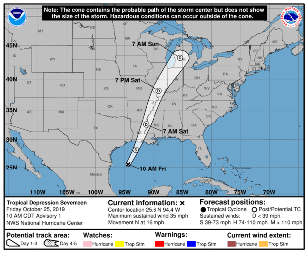
The map below was from Friday.
The radar loop below shows ex-Olga tiny signature in Mississippi RACING northward. If you are looking at this in a few hours, this will already be in TN, then KY and northward.
This is really going to effect winds, especially on the east side of the remnants later today..........which is where the speed of Olga will ADD to the winds circulating around the actual system.
I think the local NWS offices and products may be underforecasting those winds. We could see gusts of 50 mph late Saturday.

This radar loop is where we will be able to see and track the remnant circulation later on Saturday:

Go to: Most Recent Image
| National |
As stated on Saturday Morning when the remnants of Olga were still in the south, I was expecting an area of high winds just to the right of Olga's path as it tracked northward.
In fact, winds gusted to 60 mph here in southwest IN on Saturday afternoon and we had many thousands without power for more than 24 hours.........including my daughter and her family.
You can see the well defined track of the high wind reports below from Saturday, just barely to the right(east) of the path of Olga as it raced northward.
https://www.spc.noaa.gov/climo/reports/191026_rpts.html
| Note: All Reports Are Considered Preliminary | |||||||||||||||
| |||||||||||||||

| |||||||||||||||