Models 12Z Sun vs 12Z Fri in terms of US HDD comparing common days:
GEFS -9
EPS: +4
So, pretty neutral overall.
4:54 PM EST Edit: Barring a colder 18Z GFS/GEFS, my guess is that there will be a pretty decent drop at the open because it seemed to hold up well on Friday despite much warmer Thu night models and 12Z Fri neutral models that mainly maintained those warmer Thu night ones. With still no sustained cold in sight and supply/production high, what's to keep it from opening a good bit down?
Thanks Larry!
I'm in Indianapolis, out of town for my grandaughers cheer competition.
Won't be home for 6-7 hours.
To me, the models and outlook are milder. Cold risks less with AO closer to 0 Vs soldly negative at 2 weeks the last few days.
OK, a few minutes after that post I had the chance to look at the 12z Canadian ensemble model and see bitter cold cross polar flow bringing Arctic air sou5h thru Canada to the US border or possibly farther sou5h with that pattern.
Some solutions are very frigid.
So I have no idea what the models will be showing the next few days for that period.
Not that it might mean much. But I was just watching a video from the NWS about general predictions for Jan-March. Due to a warm Pacific, and something they referred to as "the blob" in the north Pacific, that it would cause the jet stream to curl down closer to the Rockies in January. Bringing slightly below average cold for the upper midwest and east.
But February and March appeared to level out to average or better temps. Not that I depend on such long term outlooks. But it doesn't look like we will have as many heating days as we would like to see.
We opened lower and those were the lows from what I could tell.
GFS ensembles came out much milder but we actually made new highs by several ticks after that and pulled back a bit but are still a bit higher.
Pretty tight range and not that far away from Friday’s close. Quiet and uncertainty for a Sunday night.
With milder maps not pressuring ng, one might assume that colder ones overnight could be quite bullish.
However, if the EEs are much milder too, that should be too bearish for ng to not feel some selling pressure.
This evening's NG is a very clear example of it not paying much attention to wx or at least giving something else higher priority. There are times even during prime heating season when wx takes a back seat. This seems to be one of them.
Mark,
Always possible. But at night? And what would be underlying reason(s) to go long or short cover?
Indecision on the part of other traders. At least that would be my POV. Since the weather is amuck, I think traders are wondering if the funds might start calling in their shorts. Personally, I'm looking for a short entry. Thinking I'm about to find it.
Short at 2.304. Gonna find out.
Bought out at 2.296. Apparently, not as much confidence as I predicted. But not leaving money on the table.
Looming Cold Snap Boosts Natural Gas Futures Early Monday
8:43 AM
Natural gas futures were higher early Monday as a cold front expected by the middle of the week gave a slight boost to prices. The January Nymex gas futures contract was trading at $2.315, up 1.9 cents, at around 8:20 a.m. ET. February was up 1.5 cents to $2.297
EE overnight did have a couple more heating degree days but the GFS ensembles continues to be a bit milder than some recent solutions.
Per NGI: "Natural gas futures were higher early Monday as a cold front expected by the middle of the week gave a slight boost to prices."
Now it is up `7 cents, more than a slight boost. I don't at all believe that this day 2-4 cold snap, which was to a large extent already baked in Fri other than an addition of a few HDDs over the weekend, is the primary cause of NG being up 7 cents. I think it is something else, perhaps having to do with the latest China trade developments or some totally different set of factors. Wx itself is taking a back seat right now imo. It can and does do that even during the winter sometimes. Wx related demand is a major factor but it isn't the entire supply/demand equation. Also, there could be technical factors coming into play like very high % of specs being short with year end approaching.
Mark, nice cover! You got what you could and avoided a loss that would have occurred just a little later.
Mark,
Nice (lucky) short trade since you were thinking ng would go lower but great timing to lock in a small gain.
Weather Monday:
for week ending December 6, 2019 | Released: December 12, 2019 at 10:30 a.m. | Next Release: December 19, 2019
| Working gas in underground storage, Lower 48 states Summary textCSVJSN | |||||||||||||||||||||||||
|---|---|---|---|---|---|---|---|---|---|---|---|---|---|---|---|---|---|---|---|---|---|---|---|---|---|
| Historical Comparisons | |||||||||||||||||||||||||
| Stocks billion cubic feet (Bcf) | Year ago (12/06/18) | 5-year average (2014-18) | |||||||||||||||||||||||
| Region | 12/06/19 | 11/29/19 | net change | implied flow | Bcf | % change | Bcf | % change | |||||||||||||||||
| East | 867 | 891 | -24 | -24 | 735 | 18.0 | 839 | 3.3 | |||||||||||||||||
| Midwest | 1,013 | 1,040 | -27 | -27 | 889 | 13.9 | 1,009 | 0.4 | |||||||||||||||||
| Mountain | 193 | 200 | -7 | -7 | 161 | 19.9 | 200 | -3.5 | |||||||||||||||||
| Pacific | 276 | 286 | -10 | -10 | 240 | 15.0 | 312 | -11.5 | |||||||||||||||||
| South Central | 1,168 | 1,174 | -6 | -6 | 899 | 29.9 | 1,173 | -0.4 | |||||||||||||||||
| Salt | 321 | 316 | 5 | 5 | 270 | 18.9 | 345 | -7.0 | |||||||||||||||||
| Nonsalt | 847 | 858 | -11 | -11 | 629 | 34.7 | 827 | 2.4 | |||||||||||||||||
| Total | 3,518 | 3,591 | -73 | -73 | 2,925 | 20.3 | 3,532 | -0.4 | |||||||||||||||||
Totals may not equal sum of components because of independent rounding. | |||||||||||||||||||||||||
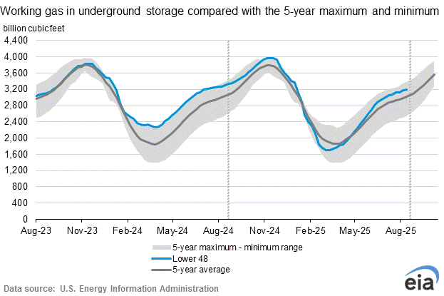
Working gas in storage was 3,518 Bcf as of Friday, December 6, 2019, according to EIA estimates. This represents a net decrease of 73 Bcf from the previous week. Stocks were 593 Bcf higher than last year at this time and 14 Bcf below the five-year average of 3,532 Bcf. At 3,518 Bcf, total working gas is within the five-year historical range.
For information on sampling error in this report, see Estimated Measures of Sampling Variability table below.
Note: The shaded area indicates the range between the historical minimum and maximum values for the weekly series from 2014 through 2018. The dashed vertical lines indicate current and year-ago weekly periods.
Latest Release Dec 12, 2019 Actual-73B Forecast-76B Previous-19B
https://www.investing.com/economic-calendar/natural-gas-storage-386
| Release Date | Time | Actual | Forecast | Previous | |
|---|---|---|---|---|---|
| Dec 12, 2019 | 10:30 | -73B | -76B | -19B | |
| Dec 05, 2019 | 10:30 | -19B | -22B | -28B | |
| Nov 27, 2019 | 12:00 | -28B | -89B | -94B | |
| Nov 21, 2019 | 10:30 | -94B | -89B | 3B | |
| Nov 14, 2019 | 10:30 | 3B | 45B | 34B | |
| Nov 07, 2019 | 10:30 | 34B | 45B | 89B |
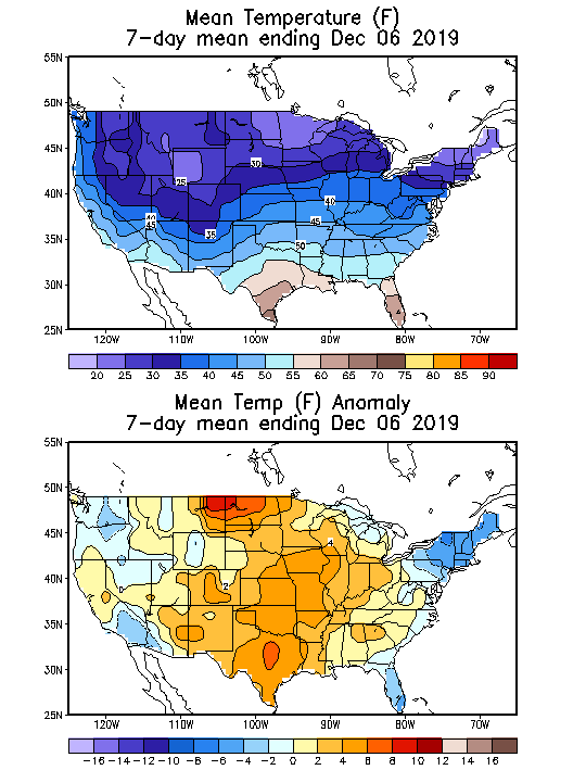
Temperatures for that 7 day period used for the EIA report ending Dec. 6.
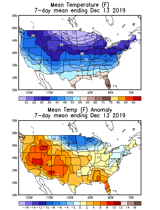
Temperatures for this Thursday's EIA 7 day period ending Dec. 13.
Frigid far Upper Midwest/N.Plains chilly Northeast.
Mild elsewhere.
Dec. 16th:
I'm repeating my comments from last week below because they explain some of the recent strength in NG prices, despite the lack of bitter cold:
Dec. 9th:
The main thing about the seasonal graph below to know is that prices in late November ALWAYS go down when its mild and almost always go down with average temperatures.......this happened in 2019.
In early/mid December, however, seasonals turn positive, which is lending some support here(along with extremely low prices and lots of warm dialed in)
This seasonal price chart below is for 2 decades, ending back in 2009.
 Seasonal Chart")
Dec. 9th:
Natural gas 3 months below
Record heat in September caused the spike higher.
Record cold in early November caused the spike higher to end Oct/early November.
Now we have a distinct double top, that will not be violated any time soon and only if the 2nd half of Winter featured sustained brutally cold temperatures.
We are easily at contract lows with the massive daily and weekly gap lower Sunday PM not showing up on the chart below but described on the 2nd post of this thread.
This gap was filled and served as an exhaustion gap formation (gap and crap) at the end of a strong price move lower. Which suggests the market will be unable to make new lows for awhile.
Dec. 16th:
The gap and crap exhaustion early last week, along with strong seasonals and very low prices has been signalling higher prices. A big sign of this has been the markets refusal to go lower during and after some key guidance has come out much milder. A long time bearish market that stops reacting to bearish news has often hit a bottom(at least short term). If it get warms enough for long enough, prices can still make new lows but the market psychology has changed/reversed since the open on Sunday Night, Dec 8th when we had a panic selling surge on the open that caused a massive gap lower. Last Tuesday had some lingering selling enthusiasm but now, the market is putting a more bullish spin on the weather(often ignoring bearish wx and focusing on bullish wx potential)
Weather stuff for Monday:
"Natural gas futures surged Monday, but gains had nothing to do with long-range weather outlooks."
"Despite some extreme volatility in recent runs, weather models have generally painted a bearish weather outlook for the latter part of December, so Monday’s futures rally had market observers looking at other reasons for the sudden move higher in the futures curve.
'Clearly, weather patterns have nothing to do with gains' on Monday since a huge amount of demand was lost Friday that held through the weekend, 'with even further milder trends in many datasets,' NatGasWeather said."
“But as far as U.S. weather patterns, they're as bearish as they have looked in more than a month,"
Natural Gas Intelligence after the close Monday:
Natural Gas Futures Rally Despite Warming Outlook; Cash Surges on Winter Blasts
5:24 PM
Natural gas futures surged Monday, but gains had nothing to do with long-range weather outlooks
Though the 2 week forecast was pretty mild, as Larry had mentioned and I did with a more detailed explanation above, natural gas is ignoring that period.
It's interesting to note the -AO however. This indice often gives us a good clue about the direction of movement of air masses in the high/mid latitudes.
It suggests that air in Canada will be moving southward. The pattern later this month is favorable for frigid air to pool into Canada so air masses that come from that direction, could potentially be extremely cold if/when they cross the border.
Most models don't show this to a great extent but the -AO makes a case for the models to be underestimating this factor.
At the distant time frame that we are talking about, there is alot of uncertainty.
Larry's favorite model, the 768 hour European model was just updated and it shows very frigid air dominating the northern tier from late December to mid January.
That model will likely look much different in 3 days on the next update because its skill is atrocious. However, it shows a -AO pattern for that period with cross polar flow at times dumping massive frigid air masses into Canada..........so to me, the risks for extreme cold in the northern tier appear to be elevated quite a bit during that period.
Mike,
in case you don't realize this, this newest 768 hour Euro was released late this afternoon (near or after the close) and therefore couldn't possibly have had anything to do with today's significant price rise. You may very well agree with me on this...I wasn't sure if you realized exactly when it is released.
Also, note that the market has been steady since its release.
After reading the closing NGI report, I'm even more convinced wx today was not near the factor it often is. I'm guessing major factor is there are just too many shorts to keep it going down in conjunction with the strong seasonals you've mentioned/year end approaching/time to get flat. etc.
I don't always agree with NGI, but today I absolutely do.
Thanks Larry!
I agree with what you are saying and realize that the 768 hour forecast could not have affected trade today BEFORE it came out but the big shift in the AO last week on Wednesday, coincided exactly with when we filled the gap lower and since then, warm model runs have not been able to keep ng down.
I can actually refer to my comments going back to last week as evidence to confirm/document that AO shift to much colder.
++++++++++++++++++++++++++++++++++++++++++++++++++++++++
https://www.marketforum.com/forum/topic/44336/
Latest, updated graph/forecast for AO and NAO here, including an explanation of how to interpret them...............mainly where they stand at the end of 2 weeks.
By metmike - Dec. 16, 2019,
Previous analysis, with the latest day at the bottom for late week 2 period.
https://www.marketforum.com/forum/t
Discussions, starting with the oldest.
(Last)Wednesday: AO drops into negative territory in week 2. NAO also falling and around 0. PNA a tad negative. Nothing huge but slightly colder than the last few days for these indices.
Thursday: AO continues to drop significantly and is pretty negative by the end of 2 weeks on some members..........increasing cold risks. NAO drops too down to a tad below 0. PNA around 0.
Friday: AO is dropping even more today with NAO going below 0. This really increases cold risks but there is a wide spread and much uncertainty. PNA a tad negative.
Saturday: AO still drops solidly negative but a wide spread with some members near zero and others extremely negative. NAO is also negative. This is favorable for cold to move from high latitudes to the middle latitudes. PNA near 0.
Monday: Negative AO is still favorable for cold to drop from high latitudes to the middle latitudes late in week 2. Slightly negative NAO could help a bit too. PNA drifts to negative territory."
++++++++++++++++++++++++++++++++
There are other things...........like seasonals, cheap prices, oversold and nobody left to sell down here but the huge gap and crap selling exhaustion formation early last week(on the dailies and weeklies) was a pretty powerful chart formation.
Thursday seemed to be the day for the bulls to really take over. That's when we completely filled the daily gap lower from Fri and closed above it despite a slightly bearish EIA report.
I was trading the 6z GFS ensemble just after 5 am Thursday. When it came out much milder, I went short but ng, instead of immediately dropping, held the gains for quite awhile(the 0z EE had come out a bit colder a few hours earlier, so that might have still had some bullish effect).
It finally did drop briefly but came right back to trade higher than before the release of the milder GFS Ensembles. That was sort of a wake up call that ng was not going lower in this environment with the same gusto it had been recently on milder models.
Also noted last night, this same price action.
We opened lower on a milder GEFS, that you showed us to start this thread.........but then, when an even milder 18z GEFS came out, we actually made new highs by a few ticks.
The next 0z GEFS that came out after 11pm was even milder yet and we spiked below the opening lows briefly but could not stay down there. 2 hours later, a slightly milder operational Euro caused us to test those lows but the lows held the rest of the night, even with the 6z GEFS coming out similar to the 0z run(pretty mild).
When the big traders took over at that point, they were clearly in a bullish mood and took us quickly to moderate gains.
Despite this, the highs of today have still not come close to testing the highs of any trading day the week before last because the mild 2 week forecasts are causing the gains to be limited.
However, in this current environment, if the models were to suddenly turn much colder, lets say overnight, then we could have some nice upside potential.
We're well above the November low and what was the contract low at that time of 2.270.
The previous contract low was just below 2.500 and you remember how just before Thanksgiving, that level was temporarily acting as good support. I think a couple of days of colder weather models would at the very least take us back to 2.500.
This is just speculating on the potential bullish case. It's extremely difficult to be bullish, however with the next 2 weeks looking so mild.
If the models keep getting milder, the decrease in demand expectations may eventually take a toll and we will have no choice but to go lower.
NGI Tuesday Morning: Natural Gas Futures Slip on Warming Weather Outlook
metmike: models continued to get milder overnight. especially the EE model. When that came out much milder, ng dropped hard. Just too mild to not go lower but it could be short lived......... the spike down to test this weeks lows held
Weather Tuesday:
From Mike's NGI link this morning:
"Weather patterns trended notably milder on Friday and have continued to warm ever since, resulting in large losses in demand that natural gas traders appeared to ignore on Monday as prices rallied. Market observers pointed to other factors for the unusual price gain in the face of warmer forecasts, including a tighter supply/demand balance, speculative trading and seasonal buying ahead of the official start of winter this weekend."
“'So it’s up to the natural gas markets to decide between very bearish weather patterns after Thursday or if tightening in the supply/demand balance, or whatever reasons drove Monday’s gains, will be strong enough to overcome it,' the forecaster said."
Thanks Larry.
NG was tanking this morning, from milder models, until the added cold snap came out on the GFS Ensembles.......which immediately have us a nice bounce..........that has been holding.
"12/17 02:23p CST  DJ Natural-Gas Shorts at Highest Level Since Financial Crisis

By Sarah Toy
     Hedge funds and other money managers have built up the largest bet in
more than a decade that natural-gas prices will fall.

     Net bets on declining natural-gas prices are at their highest level since
2008, according to U.S. Commodity Futures Trading Commission data, highlighting
how a glut of supply and mild winter weather continue to weigh on investors'
views of the commodity.

     Investors have become increasingly pessimistic over the past several
weeks as they wait for colder temperatures to lift demand, with wagers on
falling prices outnumbering bullish wagers by 242,833 contracts during the week
ended Dec. 10."
Wow Larry! That's huge,thanks.
Should we get into a sustained period of extreme cold, that could provide some major ammo for short covering and a big spike higher.
This also helps to explain the selling exhaustion/gap and crap.
The huge funds have been piling on the shorts and adding to their positions as they will do, following the trend and fundamentals lower.....until things got way overdone..........and we ran out of big sellers down here.
We can still make new lows if the rest of Winter ends up mild of course.
The last 18z operational GFS had extreme cold and the southern part of the polar vortex dropping to the Upper Great Lakes but as we both know, this is unlikely to verify.
The ensemble average did not have this but with the AO now forecast for that period to be negative for numerous days now, I think the odds for that to happen are elevated vs if we did not have the AO dropping so low.
The market is in a perfect buying set up if it would just turn MUCH colder.
Natural Gas Futures Head South for Winter as Warmer Trends Continue
5:34 PM
Increasingly warmer weather outlooks proved too much for natural gas traders to ignore on Tuesday, with prices erasing about half the gains picked up the previous day. The January Nymex gas futures contract settled at $2.319, down 2.2 cents day/day. February slipped 2.3 cents to $2.303.
NGI From early morning Wednesday:
Bears Take Out $2.30 in Early Natural Gas Futures Trading as Forecasts Warm Further
8:32 AM
After several failed attempts, natural gas bears took out a stubborn level of support early Wednesday as weather models continued to trim demand from their outlooks. The January Nymex gas futures contract was trading at $2.268 at 8:15 a.m. ET, down 5.1 cents from Tuesday’s close.
AO has half the members bouncing back to 0 this morning at the end of 2 weeks, with half still strongly negative.
Weather Models Curb Demand; Natural Gas Futures Slip Again
5:40 PM
With projected demand in long-range weather forecasts continuing to decline midweek, natural gas futures softened for the second day in a row. The January Nymex gas futures contract settled Wednesday at $2.286, down 3.3 cents on the day. February slid a more pronounced 3.9 cents to $2.264
This was the Wednesday weather update:
With the report coming out tomorrow, I think it will be neutral to bearish.
That has been the case more often than not recently Mark. Thanks for your thoughts.
NGI Thursday morning:
Warmth Seen Lasting Further Into January as Natural Gas Futures Slide Early
8:56 AM
Weighed down by the prospect of warmer-than-normal conditions stretching further into the month of January, natural gas futures were trading several cents lower early Thursday. The January Nymex contract was down 4.5 cents to $2.241/MMBtu as of 8:30 a.m. ET.
metmike: Weather models turned milder overnight. Incredibly mild weather coming up with less threat for turning cold in week 2................AO not as negative again today at the end of 2 weeks with a couple members still holding on to an extreme negative.
for week ending December 13, 2019 | Released: December 19, 2019 at 10:30 a.m. | Next Release: December 27, 2019
| Working gas in underground storage, Lower 48 states Summary text CSV JSN | |||||||||||||||||||||||||
|---|---|---|---|---|---|---|---|---|---|---|---|---|---|---|---|---|---|---|---|---|---|---|---|---|---|
| Historical Comparisons | |||||||||||||||||||||||||
| Stocks billion cubic feet (Bcf) | Year ago (12/13/18) | 5-year average (2014-18) | |||||||||||||||||||||||
| Region | 12/13/19 | 12/06/19 | net change | implied flow | Bcf | % change | Bcf | % change | |||||||||||||||||
| East | 838 | 867 | -29 | -29 | 698 | 20.1 | 808 | 3.7 | |||||||||||||||||
| Midwest | 973 | 1,013 | -40 | -40 | 847 | 14.9 | 972 | 0.1 | |||||||||||||||||
| Mountain | 186 | 193 | -7 | -7 | 154 | 20.8 | 193 | -3.6 | |||||||||||||||||
| Pacific | 273 | 276 | -3 | -3 | 229 | 19.2 | 305 | -10.5 | |||||||||||||||||
| South Central | 1,142 | 1,168 | -26 | -26 | 865 | 32.0 | 1,142 | 0.0 | |||||||||||||||||
| Salt | 319 | 321 | -2 | -2 | 263 | 21.3 | 335 | -4.8 | |||||||||||||||||
| Nonsalt | 823 | 847 | -24 | -24 | 602 | 36.7 | 807 | 2.0 | |||||||||||||||||
| Total | 3,411 | 3,518 | -107 | -107 | 2,793 | 22.1 | 3,420 | -0.3 | |||||||||||||||||
Totals may not equal sum of components because of independent rounding. | |||||||||||||||||||||||||
Working gas in storage was 3,411 Bcf as of Friday, December 13, 2019, according to EIA estimates. This represents a net decrease of 107 Bcf from the previous week. Stocks were 618 Bcf higher than last year at this time and 9 Bcf below the five-year average of 3,420 Bcf. At 3,411 Bcf, total working gas is within the five-year historical range.
For information on sampling error in this report, see Estimated Measures of Sampling Variability table below.
Note: The shaded area indicates the range between the historical minimum and maximum values for the weekly series from 2014 through 2018. The dashed vertical lines indicate current and year-ago weekly periods.
https://www.investing.com/economic-calendar/natural-gas-storage-386
Latest Release Dec 19, 2019 Actual-107B Forecast-90B Previous-73B
| Release Date | Time | Actual | Forecast | Previous | |
|---|---|---|---|---|---|
| Dec 19, 2019 | 10:30 | -107B | -90B | -73B | |
| Dec 12, 2019 | 10:30 | -73B | -76B | -19B | |
| Dec 05, 2019 | 10:30 | -19B | -22B | -28B | |
| Nov 27, 2019 | 12:00 | -28B | -89B | -94B | |
| Nov 21, 2019 | 10:30 | -94B | -89B | 3B | |
| Nov 14, 2019 | 10:30 | 3B | 45B | 34B |
Thursday weather:
The -107 today is a whopping 19 higher than forecasted by the WSJ poll! In that way, it is the most bullish report since early January and the 2nd most bullish one of 2019. Is this just a blip like happens sometimes? The good chance that this is just a blip is why after a kneejerk going in the direction suggested by the report, NG will often reverse soon after like what occurred today.
If it is not a blip, NG is likely near its bottom for awhile assuming the wx forecasts don't get any warmer in early Jan (a big IF), especially considering how short specs already are. We'll know within a few weeks if this was a bullish EIA blip.
EE came out much colder late week 2 and giving ng a big bounce.
I got lucky this morning. My overall position was slightly short. I bought it back for a small profit before the report came out. Then once the report came out a sold a put. Bought it back this afternoon for a small profit. Looking ahead to the middle of January, Ensembles are showing a large area of below average temperatures in the Arctic region and across Russia. If we get another cross polar flow looks like we could really get cold the second half of January.
Congrats Grant!
Of course a January forecast time frame is very low skill but the NWS updated their forecast for January today and it lines up with your thoughts that some of that cold will make it into at least the northern tier of the US.
If you'd asked me earlier this week, I would have agreed with this idea based just on the forecast -AO at the end of week 2 since last Weekend. However, the AO is not so negative now at that time frame, with some even going positive but still a couple extremely, bottom of the chart negative.
Look at the incredible spread though at the end of the period!!! Great uncertainty.


The European model 768 hour forecast which was just updated doesn't really turn on the sustained, widespread cold until the start of the 2nd week of January(then it stays pretty cold) and the chances of it being correct at that distant time frame are not much better than flipping a coin but there are some other indicators that the NWS points to in its just updated January outlook that line up for cold that, at the very least enhances the chances of it being very cold during that time frame.
I would not trade on that information, other than knowing that it exists and at times, the market can trade on speculation of something that gets more weighting than it deserves based on realities.
If we do get the models to shift colder, it's a nice buying set up but with the balmy weather pattern next week, I wouldn't want to be long if that shows no sign of changing.
Tomorrow, Friday we can trade what might be on Sunday Night and some traders will feel much more bullish tomorrow after seeing this very bullish EIA number.
On Sunday Night, the EIA number won't matter much anymore.
If we come in Sunday Night with a week of temperature anomalies that look like the ones below and add another week to that, it hard to imagine the market not going lower.
Temperatures vs average for days 3-7.
Warming to much above average in the Plains/Midwest. Look at all the red and the magnitude of the anomalies!
https://www.wpc.ncep.noaa.gov/medr/medr_mean.shtml


I am thinking we may see it drop a little tomorrow with the warm two weeks likely ahead. My plan is to sell a put if it drops a couple of cents.
Well. It went two cents the wrong way for me. So now it needs to drop 4 cents. Then I’ll look at selling a 30 delta put.
You probably noticed that it spiked higher after the GFS Ensembles came out colder in week 2.
If the EE coming out the next 45 minutes is the same as the previous run or milder, then we can come back down.
We are already doing that with a slight pullback on the European model, operational 0z run actually a tad colder than the previous run, so I don't think we will come all the way back down unless the EE is at least a bit milder.
It is very interesting how much is jumps for each model run. Especially in winter. I am still learning what to watch but I am remembering what happens. I can imagine the volatility would have been much greater when the storage was much lower.
Though the EE did come out a bit milder with regards to HD's, the last few maps show a a possible pattern change to much colder.....ridge/west, trough/east couplet...so my impression is that the market is viewing this as bullish since some other models show but there is disagreement.
December 20, 2019
Coming off a bullish inventory report, and with hints of cold returning in early January, natural gas futures were trading higher early Friday. At around 8:40 a.m. ET, the January Nymex contract was up 5.2 cents to $2.325/MMBtu.
The early gains Friday were “largely technically driven,” according to analysts at EBW Analytics Group. The firm modeled day/day demand losses based on the latest temperature outlook through Jan. 2.
However, the move higher “is reinforced by model runs that show an increased risk (still less than 50%) of the potential for temperatures to return to seasonal norms in early January,” the EBW analysts said. “Natural gas prices will be heavily influenced by midday model runs and even more by continued shifts in ensemble model runs over the weekend.
“By early next week, the January contract could fall to as low as $2.20 or test resistance at $2.38, depending upon how the uncertainty regarding early January sorts out.”
The latest European model data still showed an “exceptionally bearish pattern” through the end of the month, according to NatGasWeather. The American model added back some heating demand overnight but also “remains exceptionally bearish” over the next 11 days, the forecaster said.
“Most of the weather data continues to favor colder air finally returning into the northern U.S. Jan. 1-4, but still quite mild elsewhere,” NatGasWeather said. Both American and European datasets show national heating degree days running significantly warmer than normal over the next 15 days and “are as bearish as they’ve been in months. Yet buyers keep stepping in anytime prices dip several cents under $2.30.
“...Over the weekend, weather patterns are going to need to look much more intimidating if bearish weather headwinds are finally to end...Also of consideration, speculators remain heavily short with expiration of January 2020 late next week, so players could need to reposition today knowing lighter trade will be coming next week due to the holiday.”
Meanwhile, analysts have been mulling the balance implications of Thursday’s Energy Information Administration (EIA) storage report, which surprised the market with a triple-digit withdrawal. EIA reported a 107 Bcf pull for the week ending Dec. 13, compared with a 132 Bcf withdrawal recorded in the year-ago period and the 112 Bcf five-year average draw.
Total working gas in storage as of Dec. 13 stood at 3,411 Bcf, 618 Bcf higher than the year-ago period and the 112 Bcf five-year average draw."
Fridays weather:
NGI after the close on Friday:
Natural Gas Futures Gain as Bulls Look to Early January for Colder Temps
5:41 PM
Tighter balances and signs of colder temperatures returning by the first week of January helped bolster natural gas futures prices Friday. After trading as high as $2.345/MMBtu, the January contract went on to settle at $2.328, up 5.5 cents day/day. February picked up 4.5 cents to settle at $2.310.
Weather Saturday:
The NWS automated 6-10 and 8-14 day outlooks came out very mild again but they don't tell us what is really going on.
The last 12z GFS ensemble was quite a bit colder in week 2 and the last 18z run was much colder than that.........now with widespread extreme cold over the eastern half of the country in week 2.
The European Ensembles were just slightly colder at the end of the period vs previous runs but all the models do turn it colder in week 2........its just a matter of how cold.
A little below average on the EE?
Much below average on the GFS ensembles?
Remember what I said two days ago about that very bullish EIA:
"If it is not a blip, NG is likely near its bottom for awhile assuming the wx forecasts don't get any warmer in early Jan (a big IF), especially considering how short specs already are. We'll know within a few weeks if this was a bullish EIA blip."
From what I've seen of the models and I think Mike would agree, they have warmed further in most of late Dec. vs yesterday but have also cooled in early Jan and overall look pretty cold at the end of week 2. Whereas on a net basis, the latest full Euro ens (12Z) has warmed a good bit (~11 HDD) despite the somewhat colder end, the latest GFS ens (18Z) has cooled a fair amount (~5-6 HDD). IF NG had opened this evening, I think it would have gone up a few more cents despite the EE being net warmer because they're both colder in early Jan and NG is still pretty cheap relatively speaking, especially considering the very bullish EIA that's still vivid.
I do agree with that Larry.
I also think that no matter how warm week 1 gets vs the week 1 forecasts from Friday, it won't matter.
A very warm week 1 was dialed into the psychology and its only 1 week any way, which will not matter as much as what the January pattern brings. If week 2 continues to morph colder, the market will speculate and extrapolate this into something much more than just the HDD's during week 2 vs what they were on Friday.
If the large scale pattern forecasts continue colder as week 2 goes on, odds are good that this will extend into week 3 and odds are high that this will not suddenly reverse back to warmer(at least the market will view it that way).........the trend in the models is important.
That said, the AO is not at all in agreement with a strong negative which often accompanies sustained, frigid periods in the US, as that is favorable for cold air to be flushed from high to mid latitudes.
Huge spread.........big uncertainty.
The potentially most bullish element, especially on the GFS Ensembles is the "possible" cross polar flow which would bring the coldest air of all(on the planet) from Siberia(where temps drop very low at this time of year in the midst of the long, dark heat losing days) into Canada. This means cold fronts from Canada could pack a polar punch.
On the individual solutions below from the GFS ensemble 12z run at 384 hours(the 18z run was even colder) a few have a well defined cross polar flow and a few others with strong upper level ridging in Western Canada that would produce an impressive ridge/downstream trough couplet that would take cold from Canada and drive it deeply into the US.
So we actually have very good agreement on these maps below for some of the main features at this distant time frame......the ridge/west, trough downstream.
This is one of the textbook upper level patterns that cause widespread cold in the US.

Wow! Huge changes on the models.
The 0z GFS brings the polar vortex down with around 3 different surges of cold into the N/C Plains then Midwest to Northeast with temperatures 40 degrees below average at times in the middle of the coldest air.
This is an extreme outlier and not likely.
Surprisingly, the GFS ensembles went the exact opposite way.
After the previous 2 runs were much colder in week 2, this last run has warmed back up to being similar to 3 runs ago.
The operational Euro is just out and is a bit milder too.
The Canadian ensembles 0z run look similar, maybe a tad less cold.
Larry,
Earlier, I was in agreement with you on ng trading higher if it was open because the GFS ensembles were so much colder but them warming up makes it uncertain. If the EE is milder too, then we could go the other way........but of course there will be more updates Sunday.
WOW!
The guidance looking much colder peaked with those 18z GFS ensembles models yesterday, although the outlier extreme cold 0z GFS last night was never considered credible.
The 6z GFS did not have that........was light years less cold and the latest 12z GFS is not coming in all that cold in week 2......in fact, a very mild start.
The ensembles were also milder at 0z and 6z then the previous couple of runs.
The EE was also milder..........not that cold, closer to normal week 2.
The actual pattern still suggests a potential ridge west trough east couplet developing in week 2, so it might start turning colder again but the trend has been milder since yesterday afternoon. Also, I think the NWS extended maps forecasts will start turning colder, especially in the 8-14 day.
Sunday's weather: