Rains the past 24 hours...........I states.
![]()
Rains that fell, were over some of the driest areas. The map below is rain over the previous 4 weeks compared to average:

Rain have been hitting some of the driest spots!
You can go to this link to see rain totals from recent time periods:
https://water.weather.gov/precip/
Go to precipitation, then scroll down to pick a time frame. Hit states to get the borders to see locations better. Under products, you can hit %normal.
You can see how big the dry pockets.........are shrinking are right now. Since the crop ratings are near the best ever 78% GD/EX corn and 75% beans, clearly this dryness has not effected the condition of the overall crop yet.
Crop ratings will likely drop a bit next Monday........from the dry places that don't get rains(which may come next week) but will maintain after that.
Rains the next 7 days, graph of totals. More to come in different places.
Day 1:
http://www.wpc.ncep.noaa.gov/qpf/fill_94qwbg.gif?1526306199054
Day 2:
http://www.wpc.ncep.noaa.gov/qpf/fill_98qwbg.gif?1528293750112
Day 3:
http://www.wpc.ncep.noaa.gov/qpf/fill_99qwbg.gif?1528293842764
Days 4-5:
http://www.wpc.ncep.noaa.gov/qpf/95ep48iwbg_fill.gif?1526306162
Days 6-7:
http://www.wpc.ncep.noaa.gov/qpf/97ep48iwbg_fill.gif?1526306162
Total accumulation
http://www.wpc.ncep.noaa.gov/qpf/p168i.gif?1526397762

Severe Storm Potential the next few days:
Current Day 1 Outlook | Forecaster: Kerr Issued: 10/0107Z Valid: 10/0100Z - 10/1200Z Forecast Risk of Severe Storms: Enhanced Risk |
Current Day 2 Outlook | Forecaster: Bunting Issued: 09/1728Z Valid: 10/1200Z - 11/1200Z Forecast Risk of Severe Storms: Slight Risk |
Current Day 3 Outlook | Forecaster: Dial Issued: 09/0726Z Valid: 11/1200Z - 12/1200Z Forecast Risk of Severe Storms: Slight Risk |
Current Day 4-8 Outlook |
Areas that could have excessive rains the next 3 days:
Excessive Rainfall Forecasts
Current Day 1 Forecast Valid 15Z 06/11/18 - 12Z 06/12/18 |
Day 1 Threat Area in Text Format
| Day 2 and Day 3 Forecasts |
Current Day 2 Forecast Valid 12Z 06/12/18 - 12Z 06/13/18 |
Day 2 Threat Area in Text Format
Current Day 3 Forecast Valid 12Z 06/13/18 - 12Z 06/14/18 |
No major threats the next 10 days(after that, the pattern may turn drier??)
Jet Stream on June 21

24 hour rains on June 21 
A shot of intense heat for a several days late this week/weekend, especially swest belt but not lasting. Day 5 highs below...........lots of U-90's!
http://www.wpc.ncep.noaa.gov/medr/DAY5_MAX_filled.gif

Sorry for Jumping around a bit here with time frames...........back to more extended.
Canadian ensembles give an extreme range in possibilities at the end of week 2. The market is not trading that but the chance of it turning ultra bullish is there as well as it possibly being very bearish............based on several individual ensemble members.
384h GZ 500 forecast valid on Jun 27, 2018 00 UTC


Forecasts for the control (GEM 0) an
CFS weeks 3-4. Mostly for entertainment purposes but better than flipping a coin.
Heat really picks up:
Back to the latest, just updated 12Z Canadian ensembles. Am not picking this for any other reason than its intriguing to me at the moment that a significant number of the individual members have an impressive heat ridge..........while just as many have the complete opposite pattern.
The ensemble mean(average of all of them together) often yields the best forecasting guidance tool but in this case, very few of the individual members have the pattern of the average because we have the 2 opposite extreme camps that sort of cancel each other out.
In a case like this, the chance of 1 of the extremes occurring is higher than usual. What alot of meteorologists will do in a case like this is to take the average..........hedge their bets sort of thing vs going with 1 camp and taking the chance of really busting bad if the opposite solutions are right.
What am I doing?
I'm just telling you about it and looking forward to the next exciting model run solution that might provide a clue to solve the mystery question: "what will the weather be like later this month"
384h GZ 500 forecast valid on Jun 27, 2018 12 UTC


Tune in to our next exciting episode of "As the Weather Turns"
Now that we have weatherdavid here, maybe it will get even more exciting!
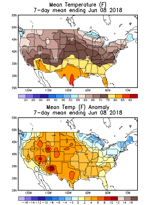
These were the temp anamolies from last week, ending Friday.
Cool Northeast quadrant, very warm southwest of that to intense heat in the Plains to Rockies/parts of the West.
The just updated 1`2Z GFS ensembles at the end of week 2 agree mostly on a cool upper level trough in the north.
They do have a heat ridge in the south that could be anywhere.

NWS extended guidance............very warm and wet. They don't believe the coolish GFS ensembles.
| 6 to 10 Day Outlooks | |
| Valid: June 17 to 21, 2018 Updated: 11 Jun 2018 | |
| Click below for information about how to read 6-10 day outlook maps Temperature Precipitation | |
| Click below for archives of past outlooks (data & graphics), historical analogs to todays forecast, and other formats of the 6-10 day outlooks ArchivesAnalogsLines-Only FormatGIS Data | |
Temperature Probability | |
Precipitation Probability | |
| 8 to 14 Day Outlooks | |
| Valid: June 19 to 25, 2018 Updated: 11 Jun 2018 | |
| Click below for information about how to read 8-14 day outlook maps Temperature Precipitation | |
| Click below for archives of past outlooks (data & graphics), historical analogs to todays forecast, and other formats of the 8-14 day outlooks ArchivesAnalogsLines-Only FormatGIS Data | |
Temperature Probability | |
Precipitation Probability | |
I've watched this site for a very long time. I've never seen patterns this chaotic looking.
But - there has been a persistent flow of moisture out of the gulf into the center of the country. This is a very good visual of that flow.
https://earth.nullschool.net/#current/wind/isobaric/1000hPa/orthographic
