Read and learn about history......pick out a good one for us!
https://en.wikipedia.org/wiki/May_18
1860 – Abraham Lincoln wins the Republican Party presidential nomination over William H. Seward, who later becomes the United States Secretary of State.
1917 – World War I: The Selective Service Act of 1917 is passed, giving the President of the United States the power of conscription.
1974 – Nuclear weapons testing: Under project Smiling Buddha, India successfully detonates its first nuclear weapon becoming the sixth nation to do so.
1980 – Mount St. Helens erupts in Washington, United States, killing 57 people and causing $3 billion in damage.
2005 – A second photo from the Hubble Space Telescope confirms that Pluto has two additional moons, Nix and Hydra.
https://en.wikipedia.org/wiki/Mount_St._Helens
Mount St. Helens is most notorious for its major eruption on May 18, 1980, the deadliest and most economically destructive volcanic event in U.S. history.[2] Fifty-seven people were killed; 250 homes, 47 bridges, 15 miles (24 km) of railways, and 185 miles (298 km) of highway were destroyed. A massive debris avalanche, triggered by an earthquake of magnitude 5.1, caused a lateral eruption[3] that reduced the elevation of the mountain's summit from 9,677 ft (2,950 m) to 8,363 ft (2,549 m), leaving a 1 mile (1.6 km) wide horseshoe-shaped crater.[4] The debris avalanche was up to 0.7 cubic miles (2.9 km3) in volume. The Mount St. Helens National Volcanic Monument was created to preserve the volcano and allow for the eruption's aftermath to be scientifically studied.
| Mount St. Helens | |
|---|---|
 3,000 ft (1 km) high steam plume on May 19, 1982, two years after its major eruption 3,000 ft (1 km) high steam plume on May 19, 1982, two years after its major eruption | |
| Elevation | 8,363 ft (2,549 m) |
| Prominence | 4,605 ft (1,404 m) |
| Listing | |
| Coordinates |  46°11′28″N 122°11′40″WCoordinates: 46°11′28″N 122°11′40″W [1] 46°11′28″N 122°11′40″WCoordinates: 46°11′28″N 122°11′40″W [1] |
| Native name | |
 Mount St. Helens Skamania County, Washington, United States | |
| Parent range | Cascade Range |
| Topo map | USGS Mount St. Helens |
| Age of rock | < 40,000 yrs |
| Mountain type | Active stratovolcano (Subduction zone) |
| Volcanic arc | Cascade Volcanic Arc |
| Last eruption | 2004–2008 |
| First ascent | 1853 by Thomas J. Dryer |
| Easiest route | Hike via south slope of volcano (closest area near eruption site) |
https://www.cbsnews.com/video/looking-back-at-the-mount-st-helens-eruption/
Forty years ago, on May 18, 1980, a volcano in Washington state erupted, killing 57 and triggering a debris avalanche that destroyed hundreds of square miles of forest. Correspondent Luke Burbank talks with Steve Olson, author of "Eruption: The Untold Story of Mount St. Helens," about the largest volcanic event in U.S. history.May 17, 2020
I think it was a couple of days later, in Detroit, I noticed a thin layer of volcanic ash on my car in the morning.
We were downwind over 2,000 miles from where the eruption occurred.
Who else remembers the eruption?
https://www.graphicnews.com/en/pages/17064/volcano-mount-st-helens-eruption-imminent
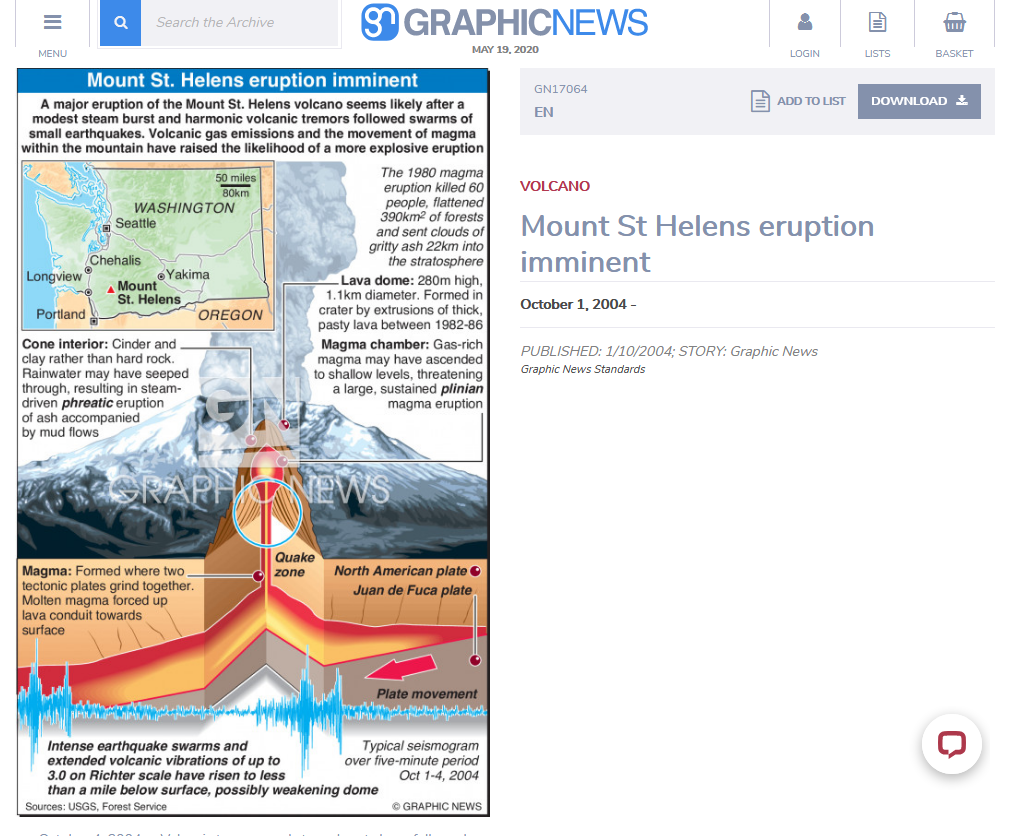
October 4, 2004 -- Volcanic tremors and steam bursts have followed earthquake swarms measuring up to 3.0 on the Richter scale within Mount St. Helens in Washington State. The emission of volcanic gases and the movement of magma within the mountain indicate a major eruption is now likely. Graphic shows cross-section through Mount St. Helens showing build-up of pressure within the
I remember. The 5.1 earthquake that happened when it erupted, woke me up in Seattle and I saw several of the smaller eruptions that happened in the following weeks.
The next year, after things calmed down, I climbed the south side of what was left of the mountain to the rim overlooking the new steaming crater. It was a miserable climb with the deep ash constantly getting into our boots, two steps up, one sliding back, the slightest breeze blowing ash into air reducing visibility and making it hard to breathe.
A few years later I hiked across in front of the newly forming dome inside the crater. Here and there new growth was already popping up though the ash and debris.
Thanks pj, I remember now that you did a lot of hiking and mountain climbing in your younger years.
What was your most impressive climb?
With Mt.Ranier close by, you must have done some climbs on that one.
I flew out to visit one of sisters in Portland in August 1981 and remember flying over Mt. Hood.
Yup,I remember that happening.I basically was not affected by it.
When I was a wee child I was scared to death of earthquakes and volcanoes.Probably due to watching horror shows etc.
My mother assured me volcanes were a thing of the past-they happened long ago during the "dinosaur days".
So the most profound affect Mt St Helens had on me was the discovery that my Mom lied to me! Ha!
john
Still it fascinates me that something like that could happen here in US and not in a remote and uninhabited part of the world like Im used to seeing. Not necessarily on top of the food chain,are we?
I remember the dust and remember the sky being a little darker during the day.
"Some of the ash drifted around the globe within about 2 weeks."
Compared to Crater Lake (Mt. Mazama), the Mt St Helens eruption was a "firecracker". If I remember correctly, the Mt. St Helens eruption blew out an estimated 1/2 cubic mile of material. By comparison, the Mt Mazama eruption 7700 years ago that formed Crater Lake, blew out an estimated 30 cubic miles and deposited ash inches deep as far away as the East Coast. https://pubs.usgs.gov/fs/2002/fs092-02/
The eruption(s) that formed Mono Lake in CA are estimated to have been larger yet and there is still a sizable restless magma chamber under that area.
Thanks pj,
I couldn't get that link to work. Here's a good one:
https://en.wikipedia.org/wiki/Mount_Mazama
| Climbing | |
|---|---|
| Geology | |
| Geography | |
| Naming | |
| Highest point | |
| Mount Mazama | |
.jpg) Mount Mazama collapsed into a caldera, which filled with water to form Crater Lake Mount Mazama collapsed into a caldera, which filled with water to form Crater Lake | |
| Elevation | 8,157 ft (2,486 m) [1] |
| Prominence | 382 ft (116 m) |
| Parent peak | Mount Scott |
| Listing | Oregon Highest Peaks 76th |
| Coordinates | 42°54′59″N 122°05′04″WCoordinates: 42°54′59″N 122°05′04″W [2] |
| Native name | Giiwas (Klamath-Modoc) |
 Mount Mazama Klamath County, Oregon, US | |
| Parent range | Cascade Range[1] |
| Topo map | USGS Crater Lake East |
| Mountain type | Caldera[1] |
| Volcanic arc | Cascade Volcanic Arc |
| Last eruption | About 4,800 years ago |
| Easiest route | Drive |
Mount Mazama (Giiwas in the Native American language Klamath) is a complex volcano in the state of Oregon, United States, in a segment of the Cascade Volcanic Arc and Cascade Range. Most of the mountain collapsed following a major eruption approximately 7,700 years ago. The volcano is in Klamath County, in the southern Cascades, 60 miles (97 km) north of the Oregon-California border. Its collapse formed a caldera that holds Crater Lake. The mountain is in Crater Lake National Park. Mount Mazama originally had an elevation of 12,000 feet (3,700 m), but following its climactic eruption this was reduced to 8,157 feet (2,486 m). Crater Lake is 1,943 feet (592 m) deep, the deepest freshwater body in the US and the second deepest in North America after Great Slave Lake in Canada.
Mount Mazama formed as a group of overlapping volcanic edifices such as shield volcanoes and small composite cones, becoming active intermittently until its climactic eruption 7,700 years ago. This eruption, the largest known within the Cascade Volcanic Arc in a million years, destroyed Mazama's summit, reducing its approximate 12,000-foot (3,700 m) height by about 1 mile (1,600 m). Much of the edifice fell into the volcano's partially emptied neck and magma chamber, creating a caldera. The region's volcanic activity results from the subduction of the offshore oceanic plate, and is influenced by local extensional faulting. Mazama is
https://www.livescience.com/8142-history-destructive-volcanoes.html
"The history of what is now Yellowstone National Park is marked by many enormous eruptions, the most recent of which occurred about 640,000 years ago, according to the United States Geological Survey. When this gigantic supervolcano erupted, it sent about 250 cubic miles (1,000 cubic kilometers) of material into the air. The eruptions have left behind hardened lava fields and calderas, depressions that form in the ground when material below it is erupted to the surface.
The magma chambers thought to underlie the Yellowstone hotspot also provide the park with one of its enduring symbols, its geysers, as the water is heated up by the hot magma that flows underneath the ground.
Some researchers have predicted that the supervolcano will blow its top again, an event that would cover up to half the country in ash up to 3 feet (1 meter) deep, one study predicts. The volcano only seems to go off about once every 600,000 years, though whether it ever will happen again isn't known for sure. Recently though, tremors have been recorded in the Yellowstone area."
mm: you asked about my climbs.
Did Rainier, Whitney, Adams, Hood, Baker and Shasta, as well as a number of lesser known peaks in the Cascades and Olympics. Shasta at age 65... couldn’t find anyone to go along, so did it solo.
But, the toughest one was Glacier Peak, the last of the volcanoes I hadn’t climbed. With an elevation of 10,500 ft, not in a class with the 14,000+ footers, but 33 miles in and out from the nearest road, made 8.5 miles longer, by a bridge that had washed out and not replaced, about half the distance requiring crampons and starting from low elevation and with lots of ups and downs a total of about 13,000 ft of elevation rise. Again tried to find a partner, but no luck, so at age 71, another solo.
At the end of a long first day and without being able to find anything like a really flat spot, I made a makeshift camp at about 7400 ft.
The next morning I realized that I had lost the faint trail under snow and ice, which resulted in having to backtrack, probably adding a mile or more, maybe an additional 1,000 ft of elevation and losing valuable time. I had planned to make it to the summit on the 2nd day, then back to my camp, but as the day wore on, it became apparent that wasn’t going to happen. I had the choice of whether to go back down to camp, a long way at that point and try to summit again the next day or bivouac where I was, spending the night with no tent at about 8800 ft, probably not recommended. The weather seemed good, so I took chance and decided to stick it out on a patch of uncomfortable rocks protruding from the glacier. The wind came up, intermittently blowing gritty old snow/ice slivers on me and it dropped below freezing. It was one long sleepless night. Dawn finally came and I pushed on, making the summit by about 8:30 AM.
At the end of the 3rd day I made back down to the car, one tired puppy. Glacier Peak is in about the most remote part of the Cascades. I had to drive about 40 miles before I could get cell service and let my wife, who was being treated for breast cancer, that I had made it out alive and would be able to take her to her radiation treatment the next day.
In my present state of physical (and mental) decline, it’s hard for me to believe I was able to pull it off, less than 7 years ago.
pj,
WOW!
https://www.summitpost.org/glacier-peak/150318

Glacier Peak from the North
Glacier Peak is one of the five volcanoes of the state of Washington, and is the highest mountain in Snohomish county. It has 7498 feet of prominence and ranks 5th highest on the Bulgar List (Washington Top 100). It is located in the North Central part of the Cascades which it has a wilderness named after this mountain which is called the Glacier Peak Wilderness. The Native Americans once called this peak Takobia which would translate to "The Great Parent". This peak is classified as a stratovolcanoe (Composite) which there has not been any major activity in 300 years. This peak goes unnoticed by much of the people of the Northwest due to it being so far in the crest of the Cascades, its distance from the nearest town, and the fact that its access roads have been washed out making all the approaches to its base a long hike in. Glacier Peak can be seen from many locations along the Mountain Loop Highway, North Cascades, Highway 2 area, and many other high points through out the state. But this peak is often hidden from view from many low land areas which is another big reason it goes unnoticed by many. The summit offers amazing views of many of the great peaks of Washington, as well as a view of seeing far across the state.
Evidence of volcanic activity is clearly visible in the pyroclastic flows, ash deposits, and multiple hot springs. As Washington State's most remote volcanic peak, Glacier Peak is completely surrounded by wilderness. Access requires at minimum 10 miles of hiking just to reach a "base camp".
https://www.outsideonline.com/1879841/yes-you-can-climb-mount-rainier

MEET YOUR HOSTS
There are three great guiding services on Rainier, each offering three-and-a-half-day training and summit climbs.
Since 1969, RAINIER MOUNTAINEERING INCORPORATED ($926; rmiguides.com) has guided 70,000 people on Rainier. Clients train at low elevation and spend one night at a spartan midmountain bunkhouse at Camp Muir. The cost doesn't include food ($126), gear rentals, or two nights of lodging just outside Mount Rainier National Park. INTERNATIONAL MOUNTAIN GUIDES ($1,250; mountainguides.com) and ALPINE ASCENTS INTERNATIONAL ($1,325; alpineascents.com) both began full-scale guiding on Rainier in 2007. Each spends two nights on the mountain—one at Camp Muir and one at a higher tent camp on a glacier—and train midmountain for a slightly more expedition feel. Both include breakfasts and dinners, and AAI tosses in transportation from the airport.
https://www.outsideonline.com/2330916/mount-whitney-climbing-accidents#close
https://www.fs.usda.gov/recarea/giffordpinchot/recarea/?recid=80023
| |||||||
|
https://en.wikipedia.org/wiki/Mount_Hood_climbing_accidents

Aerial view of Mount Hood's rugged north side.
Mount Hood climbing accidents are mountain climbing- or hiking-related incidents on Oregon's Mount Hood. As of 2007, about 10,000 people attempt to climb Mount Hood each year.[1] As of May 2002, more than 130 people have died climbing Mount Hood since records have been kept.[2] One of the worst climbing accidents occurred in 1986, when seven teenagers and two school teachers froze to death while attempting to retreat from a storm.[2]
Despite a quadrupling of forest visitors since 1990, the number of people requiring rescue remains steady at around 25 to 50 per year, largely because of the increased use of cell phones and GPS devices.[3] In 2006, 3.4 percent of search and rescue missions were for mountain climbers. In comparison, 20% were for vehicles (including ATVs and snowmobiles), 3% were for mushroom collectors, the remaining 73.6 percent were for skiers, boaters, and participants in other mountain activities.[4]
Regardless of route, Mount Hood is a technical climb. It requires ropes, crampons, and ice axes. Approximately 95% of Mount Hood's climbs occur April through July.[5]
https://www.mountaineers.org/activities/routes-places/mount-baker-coleman-glacier
This route gains 7,000 feet in a distance of 5.5 miles, climbing the moderate Coleman Glacier, the top part of the Deming Glacier, and Roman Wall before reaching the flat summit plateau. Views from camp and the summit are spectacular. Times: 3-4 hr trailhead to camp, 6-9 hr camp to summit.

Thanks for all the references. I was lucky enough to do most my hiking/climbing before the mobs arrived on the mtns. At the time I did it, Glacier Peak apparently was not (yet) on most people's list. In three days I spent there, I only saw 4 other people.