Beta is the one to watch(mainly a threat of heavy rains because of the very slow movement that next few days)
https://www.nhc.noaa.gov/graphics_at2.shtml?start#contents
![[Key Messages]](https://www.nhc.noaa.gov/storm_graphics/AT22/refresh/AL222020_key_messages+png/145015_key_messages_sm.png)
+++++++++++++++++++++++++++++++++++++++++++++++++++
The graphics below will allow us to monitor Beta after it develops, then over the next week.
https://www.spc.noaa.gov/exper/mesoanalysis/new/viewsector.php?sector=15
Go to: Most Recent Image

Go to: Most Recent Image
Liquid equivalent precip forecasts for the next 7 days are below.
Maybe a foot of rain along the far E.TX coast, close to the LA border!
Day 1 below
http://www.wpc.ncep.noaa.gov/qpf/fill_94qwbg.gif?1526306199054

Day 2 below:
http://www.wpc.ncep.noaa.gov/qpf/fill_98qwbg.gif?1528293750112

Day 3 below
http://www.wpc.ncep.noaa.gov/qpf/fill_99qwbg.gif?1528293842764

Days 4-5 below:
http://www.wpc.ncep.noaa.gov/qpf/95ep48iwbg_fill.gif?1526306162

Days 6-7 below:
http://www.wpc.ncep.noaa.gov/qpf/97ep48iwbg_fill.gif?1526306162

7 Day Total precipitation below:
https://www.wpc.ncep.noaa.gov/qpf/p168i.gif?1566925971

Previous tropical threads:
https://www.marketforum.com/forum/topic/58500/
Tropics August 17, 2020
https://www.marketforum.com/forum/topic/57763/
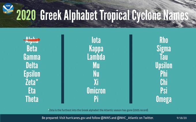
We are obliterating the record for earliest named storms, on our way to a record for the season, which WAS 28, set in 2005:
https://en.wikipedia.org/wiki/List_of_Atlantic_hurricane_records
Indicates a tie for the earliest/next earliest formation date
| Based on data from: U.S. NOAA Coastal Service Center - Historical Hurricane | |||||
|---|---|---|---|---|---|
| Name | Date of formation | Name | Date of formation | ||
| Storm # | Earliest | Next earliest | |||
| Earliest formation of north Atlantic tropical cyclones by storm number | |||||
| 1 | Unnamed | January 3, 1938 | Unnamed | January 4, 1951 | |
| 2 | Unnamed | May 17, 1887 | Unnamed | May 26, 1908 | |
| Beryl | May 26, 2012 | ||||
| 3 | Cristobal | June 2, 2020 | Colin | June 5, 2016 | |
| 4 | Danielle | June 20, 2016 | Debby | June 23, 2012 (12z) | |
| 5 | Edouard | July 6, 2020 | Emily | July 11, 2005 | |
| 6 | Fay | July 9, 2020 | Franklin | July 21, 2005 | |
| 7 | Gonzalo | July 22, 2020 | Gert | July 24, 2005 | |
| 8 | Hanna | July 24, 2020 | Harvey | August 3, 2005 | |
| 9 | Isaias | July 30, 2020 | Irene | August 7, 2005 | |
| 10 | Josephine | August 13, 2020 | Jose | August 22, 2005 | |
| 11 | Kyle | August 14, 2020 | Katrina | August 24, 2005 | |
| 12 | Luis | August 29, 1995 | Leslie | August 30, 2012 | |
| 13 | Maria | September 2, 2005 | Michael | September 4, 2012 | |
| Lee | September 2, 2011 | ||||
| 14 | Nate | September 5, 2005 | Maria | September 7, 2011 | |
| 15 | Ophelia | September 7, 2005 (06z) | Unnamed | September 19, 1936 | |
| 16 | Philippe | September 17, 2005 | Ophelia | September 21, 2011 | |
| 17 | Rita | September 18, 2005 | Philippe | September 24, 2011 | |
| 18 | Stan | October 2, 2005 | Sebastien | October 21, 1995 | |
| 19 | Unnamed | October 4, 2005 | Tony | October 24, 2012 | |
| 20 | Tammy | October 5, 2005 | Unnamed | November 15, 1933 | |
| 21 | Vince | October 9, 2005 | N/A | ||
| 22 | Wilma | October 17, 2005 | N/A | ||
| 23 | Alpha | October 22, 2005 | N/A | ||
| 24 | Beta | October 27, 2005 | N/A | ||
| 25 | Gamma | November 18, 2005 | N/A | ||
| 26 | Delta | November 23, 2005 | N/A | ||
| 27 | Epsilon | November 29, 2005 | N/A | ||
| 28 | Zeta | December 30, 2005 | N/A | ||
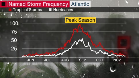
We are 10 days past the historical peak for named storms in the Atlantic basin but still a long way to go, even as named storms typically drop off fast here.
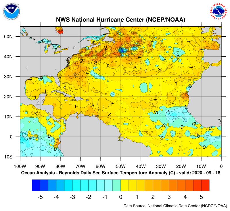
Water temperature anomalies are still on the warm side in the tropical Atlantic and Gulf of Mexico.
You can see the little cool spot along the Gulf Coast where Sally churned up some cooler, sub surface sea water.
https://www.nhc.noaa.gov/sst/rsst_atl_anom_loop.php
Tropical Storm Gamma is likely in the next couple of days..........way out in the Atlantic and no threat.
The quiet period is over. There are now 2 systems being followed:
1) TD 25: doesn't look to ever get that strong, especially if it crosses the Yucatan. and likely would have little direct effect on the US. However, it still needs to be watched all around the Gulf, regardless.
2) A wave now in the E Caribbean. Due to TD 25 as well as it not currently looking impressive due to strong shear, this one is likely not getting the attention it probably should. Most models do make this at least a TD in the Gulf at some point. The 12Z Canadian, though an inferior model, makes it as strong as a hurricane. The 0Z Euro made it a solid TS though the 12Z is much weaker with perhaps barely a TD. A decent number (though well under 50% overall) of GFS, Euro, and Canadian ensemble members make it a Gulf TS or even a H mid to late next week that in many cases subsequently landfalls on the US anywhere from Galveston, TX, to Sarasota, FL, mainly during 10/10-15 with the bulk of the hits between central LA and the Big Bend of FL.

Tropical Weather Outlook NWS National Hurricane Center Miami FL 200 PM EDT Fri Oct 2 2020
For the North Atlantic...Caribbean Sea and the Gulf of Mexico:
The National Hurricane Center has initiated advisories on Tropical Depression Twenty-Five, located over the northwestern Caribbean Sea.
1. A tropical wave is producing widespread cloudiness, showers, and thunderstorms over the eastern Caribbean Sea, with locally heavy rainfall and gusty winds affecting portions of the ABC Islands, the Lesser Antilles, the Virgin Islands, and Puerto Rico. Environmental conditions are expected to become a little more conducive for development, and a tropical depression could form next week while the system moves westward or west-northwestward at about 15 mph across the central and western Caribbean Sea. * Formation chance through 48 hours...low...10 percent. * Formation chance through 5 days...medium...40 percent.
Public Advisories on Tropical Depression Twenty-Five are issued under WMO header WTNT35 KNHC and under AWIPS header MIATCPAT5. Forecast/Advisories on Tropical Depression Twenty-Five are issued under WMO header WTNT25 KNHC and under AWIPS header MIATCMAT5.
Forecaster Berg
Thanks Larry!
Tropical Storm Delta is getting all the attention in the GOM right now.
Expected to become a cat. 2 hurricane over the next 3 days.
With low shear and very warm water temperatures, the potential is there for it to get even stronger than that.
https://www.youtube.com/watch?v=aww4HT5g7ig

Delta is the 26th named storm in 2020.
The record for named storms is 28, set in 2005. We WILL break that record.
Scroll up to see more hurricane details.
The updated forecast this evening has ramped up Delta to a major, cat. 3 hurricane with winds of 120mph. See graphics above.
Delta is now a major hurricane with 130 mph winds. It will hit the Yucatan Peninsula hard on Wednesday after possibly reaching 140 mph today. Scroll up for details.
The only good news is that the Yucatan Peninsula will be exactly in the left side, 90 degrees from the track of the hurricane, where the speed of the entire entity SUBTRACTS from the velocity of the surface winds(they ADD to the winds on the right side).
So the speed of Delta of around 17 mph in the northwest direction will subtract from the actual winds circulating around the storm. This will lower a 130 mph wind gust, for instance to 113 mph.
Then, Delta heads into the Western Gulf, possibly regaining all the strength lost from encountering the land mass on its left side.
Just before hitting the Gulf Coast, Delta is expected to track into slightly cooler waters and weaken a bit but should still be a dangerous hurricane late Friday, when that happens. ...making landfall late Friday Night or early Saturday.
Here's a diagram illustrating the principle described verbally on the previous page:
Areas to the east/northeast/right of Delta or any hurricane(the dirty side of the hurricane) because of the counterclockwise spin, will have the speed of the storm adding to the velocity of the wind.
On the west/southwest/left side of Delta or any hurricane, the opposite occurs. Winds will be less by the amount of forward speed of the hurricane.
If Delta is traveling at 17 mph in the northwest directions for instance, we subtract 17 mph from the hurricane winds on its west/southwest/left side with respect to the ground/ocean. So a 130 mph gust actually becomes a 113 mph gust.
This describes what will be happening on the Yucatan Peninsula of Mexico on Wednesday.
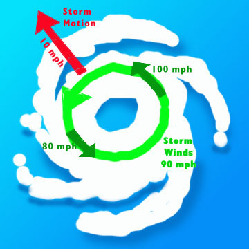
When Delta hits the Gulf Coast very early Saturday or late Friday, the same affect will occur on the left and right side of the hurricane.
Delta has weakened after hitting land today but will strengthen again, to 120 mph in the GOM, but not quite as strong as yesterdays forecast.
Also speeding up a bit, so landfall will be earlier on Friday than the previous forecast.
Delta should weaken before hitting the Gulf Coast but still be a very dangerous hurricane.
The rapid speed will keep rainfall totals from being too heavy vs a slow moving hurricane.
Delta is at 105 mph late this morning. Expected to strengthen to 115 by Friday, then weaken before hitting the coast. We/you will be able to track Delta in real time below, using constantly updated surface isobars(lines of equal pressure) and radar images for the Gulf Coast and vicinity.
https://www.spc.noaa.gov/exper/mesoanalysis/new/viewsector.php?sector=15
Go to: Most Recent Image
Sorry, but Tanya Tucker did it better.
Throwback Thursday! Yet another big hurricane about to hit where Rita did, back in 2005.
Patrick,
I believe you and thanks for the additional link.
The hurricane season of 2005 and 2020 do have quite a lot of similarities.
Delta has weakened a tad today and will hit the western Coast of LA later today as a cat. 2 hurricane with winds just above 100 mph.
See more details by scrolling above.
Hurricane Delta Tropical Cyclone Update
NWS National Hurricane Center Miami FL       AL262020
300 PM CDT Fri Oct 09 2020

...3 PM CDT POSITION UPDATE...
...CONDITIONS CONTINUE TO DETERIORATE ALONG THE SOUTHWESTERN COAST
OF LOUISIANA AND THE UPPER TEXAS COAST...

A NOAA National Ocean Service water level gauge at Freshwater Canal
Locks, Louisiana, recently reported storm surge inundation of more
than 4.5 feet above ground level.

The Texas Coastal Ocean Observation Network station at Texas Point
recently reported sustained winds of 60 mph (97 km/h) and a wind
gust of 70 mph (113 km/h).

A wind gust to 55 mph (89 km/h) has been reported at the Jack
Brooks Regional Airport near Port Arthur, Texas, within the past
hour.

A wind gust of 60 mph (97 km/h) has been observed at Nederland,
Texas.

A WeatherFlow observing site near Cameron, Louisiana, recently
reported a wind gust to 51 mph (82 km/h).


SUMMARY OF 300 PM CDT...2000 UTC...INFORMATION
----------------------------------------------
LOCATION...29.1N 93.4W
ABOUT 50 MI...80 KM S OF CAMERON LOUISIANA
MAXIMUM SUSTAINED WINDS...105 MPH...165 KM/H
PRESENT MOVEMENT...NNE OR 15 DEGREES AT 14 MPH...22 KM/H
MINIMUM CENTRAL PRESSURE...966 MB...28.53 INCHES

$$
Forecaster Brown
It is very unfortunate that this is hitting very close to the same areas hit by H Laura just 6 weeks ago!
Regarding commodities
1. This, like most W Gulf hurricanes, is having a significant impact on NG in terms of both supply and demand. On the supply side, shutins are bullish and LNG export reductions are bearish. Perhaps these are near a wash? The news sources really have a hard time with this due to the mixed messages.
On the demand side, it isn’t as bearish as it would be earlier in the season because the storm is not going to reduce overall US CDDs to the extent it would be doing during the normally hotter summer and early autumn. But it is still going to produce widespread power outages, which are bearish to some extent. The question then is going to come down to extent of outages and length of them. One thing this isn’t doing is hitting a major city head-on, which would have caused more outages and been more bearish.
2. Another commodity that will be/is being significantly impacted by H Delta is cotton due to, ironically enough, the Mississippi “Delta” region! Truth is stranger than fiction. That region is one of the two major CT regions in the SE US. The reason this is such a big deal now is that most CT has open bolls waiting to be harvested. Delta’s impact on “the Delta” will be in two ways:
- The first way being very heavy rainfall along the Mississippi River in LA, MS, and some of AR. In addition, big growing areas further N and NE like the rest of N and C MS, W TN, and NW AL will be impacted by lesser but still unwanted heavy rains this weekend.
- The other way being high winds. Most vulnerable will be the unharvested LA crop since winds will be highest there. However, winds will likely still be high enough (TS force) to cause some damage even further N and NE on some of the MS and AR crops, which have so far harvested only a small portion.
Thanks Larry!
Hurricane Delta makes landfall on Louisiana coast - live updates
https://www.cbsnews.com/live-updates/hurricane-delta-track-path-latest-news-updates-2020-10-09/
Hurricane Delta, now a Category 2 storm, made landfall near Creole, Louisiana, on Friday evening,
Back to quiet in the tropics!
But maybe not quiet for more than 7-10 days as model consensus suggests a potential late October W Caribbean genesis.
Thanks muck Larry, please keep us posted.
A disturbance around 500 miles southeast of Bermuda right now is likely to be come the next named storm, pretty far out in the Atlantic with no threat to the US mainland/East Coast after that.
Nothing else out there currently.
Epsilon will likely become a hurricane but is no threat to the US. There are no other storms in the Atlantic Basin right now.
https://www.nhc.noaa.gov/text/refresh/MIATCDAT2+shtml/191456.shtml?
Epsilon is forecast to be at or near hurricane strength when it approaches Bermuda late this week. While it is too soon to determine the exact details of Epsilon's track and intensity near the island, there is a risk of direct impacts from wind, rainfall, and storm surge on Bermuda, and interests there should closely monitor the progress of Epsilon.

Looks like tropical storm Zeta will form in the next 2 days, possibly threatening the far Southeast GOM and Southern Florida after that.
This will be the 28th named storm of the year and tie the record for most named storms set back in 2005.
That year, the 28th storm occurred on December 28th, which was actually outside of the normal June 1 - Dec 1 tropical storm season.
It's extremely likely that we will have a couple more storms but major hurricanes are less and less likely in November and there has never been a MAJOR hurricane that hit the US in November. Ocean temperatures just are not warm enough anymore and wind sheer picks up.
On October 13th, I said:
"But maybe not quiet for more than 7-10 days as model consensus suggests a potential late October W Caribbean genesis."
--------------------------------------------------------------
And here we are with TD 28, soon to be Zeta, as Mike posted.
What earlier appeared to be a possible threat to mainly S FL as far as the US is concerned has shifted much more to, where else, the N Gulf coast again! As of now, I think the highest risk is from an unseasonably very late E LA to the FL Panhandle. I wouldn't rule out FL Big Bend at all. I'd think S FL is pretty safe now but that's not set in stone yet.
What do I think this means for commodities? Well, OJ, which may have been a bit threatened when the S FL threat was higher, has little threat as of today. However, this may mean some of CT is threatened again. I think that this threat would probably be more significant if it goes into the NE Gulf rather than toward the Delta because they have a lot more not yet harvested in S AL, GA, SC, and NC and they weren't affected by Delta too much. But that is just a guess. Who knows? Perhaps getting hit by still another storm in the Delta region would be worse, especially getting still more heavy rain?
And then there's the hard to understand with regard to Gulf storms NG again.
And believe it or not being as late as it is, this may still not be the last US threat. Perhaps another W Car threat in about 2 weeks?? But that's highly speculative, way too far out for modeling to be reliable, and it will be Nov. 7th by then. So, enough about that for now.
Thanks much Larry!
Zeta is expected to become a minimal hurricane and take the path shown below.
https://www.nhc.noaa.gov/refresh/graphics_at3+shtml/024045.shtml?cone#contents

I was thinking that with November forecasts turning warmer and ng closing on its lows Friday, that we might gap lower on the open and it becoming a very bearish, downside breakaway gap.
But this tropical system was predicted to be almost no threat to the natural gas industry in the GOM as of Friday afternoon and that has changed.
There will likely be some shut ins, which is bullish as far as less production but also bearish affects on less exports.
15 years ago, production shut ins were entirely bullish since we didn't have much fracking production then and this change would cause higher prices briefly, until the hurricane past or after a brief spike higher dialed in any lost production.
15 years ago, we didn't have exports. That part of the equation in 2020 makes hurricanes in this location bearish from lost exporting.
How do you think this will affect the market Larry? Others?
I doubt there will be much affect on cotton.
Not enough rain or wind at this point.
Mike asked how do I think this storm will affect NG? I honestly have no idea. As I've said, its previous Gulf storm patterns have made little sense to me.
Mike,
I should also tell you that due to the current and projected very slow movement for the next day or so along with the real potential for a further south center relocation and the time of year, the uncertainties are much higher than normal. Therefore, the projected track may change greatly even by late tomorrow. If so, the threat to the N Gulf could go down. We'll see.
Thanks Larry,
See the links/discussion on the potential impact in this thread, which we can use to comment on the effects of natural gas.
NG 10/14+
27 responses |
Started by WxFollower - Oct. 14, 2020, 6:26 p.m.
Latest update about the same and not that threatening with the potential minimal hurricane.
I'm suspecting Dec CT is up near session highs of +0.33 now, despite the Dow futures down over 150 ,due to TS Zeta and even with it being not far from longterm highs. Let's see whether it holds up through tomorrow.
That makes sense Larry, with Cl also lower at the moment.
I noted the NHC bumped up the intensity 10 mph to 85 mph and shifted the track a tad farther west, so a slightly bigger threat to energy interests in the GOM.
I still don't see enough rain or wind to cause much damage to the cotton crop but the market doesn't care what I think.
Regarding the Delta crop, it may be more a matter of that it doesn't want to see any more heavy rains anytime soon so that what CT has been waterlogged would be able to finally dry put and also bleach out some of the discoloration caused by storm Delta's heavy rains. So, maybe it is putting in additional risk premium for either this possibility in case heavy rains shift west into the Delta region or else if it hits more of the SE crop.
This about it this way: would you feel comfortable shorting CT with still another hurricane set to hit somewhere along the Gulf coast within 2-3 days and also considering a crop that has been hit repeatedly this season? I believe there is shortage of folks who want to short this even at these relatively high prices. A shortage of shorts normally translates into higher prices.
Regardless, keep in mind the uncertainties with tracks and strength of tropical cyclones and the attendant uncertainties of heavy rains and winds. Related to this, there is a good bit of uncertainty regarding how strong this will be at landfall as well as where it will landfall and the path of the heaviest rains as well as strong inland winds.
That could be exactly right Larry.
Its not always the amounts from extreme rain events that matter.
If we get 8 inches, then it turns dry for a month.........no big deal.
If we get 5 inches, then more rains before we can dry out, then more rains..........it is a big deal.
I had some articles on this from previous years that I'll search for and post if found.
Here are the cotton threads/posts regarding Hurricane Michael 2 years ago, with some wonderful research/stats from WxFollower. Some of the best posts ever here.
Hurricane Michael obliterated much of the GA crop.
Cotton
24 responses |
Started by metmike - Oct. 29, 2018, 12:31 a.m.
https://www.marketforum.com/forum/topic/16128/
Previous cotton threads/posts:
Look like Zeta will be close to a minimal hurricane at around 75 mph when it makes landfall around New Orleans late Wednesday. No big changes in the forecast the last 24 hours.
Scroll up for more information.
We will be able to track Zeta below, the next several days using constantly updated data:
https://www.spc.noaa.gov/exper/mesoanalysis/new/viewsector.php?sector=18#

 https://radar.weather.gov/Conus/southmissvly_loop.php
Go to: Most Recent Image
Zeta up to 90mph, approaching the coast late today.
Fastest I ever remember seeing the remnants of a hurricane move across this area!
Almost 60 mph right now.
See ya later Zeta! Last NHC update just out.
https://www.nhc.noaa.gov/text/refresh/MIATCDAT3+shtml/292037.shtml?
Post-Tropical Cyclone Zeta Discussion Number  21 NWS National Hurricane Center Miami FL       AL282020 500 PM EDT Thu Oct 29 2020
Zeta lost tropical characteristics and was declared post-tropical a few hours ago.  The surface pressure field has become elongated with the center now embedded within a frontal zone over the Mid-Atlantic states.  The maximum sustained winds are still estimated to be 45 kt, based on an observation received from northeastern North Carolina a few hours ago, and winds have been increasing at marine sites located just off the Mid-Atlantic coast.
Zeta is zooming toward the east-northeast (060/48 kt), and its center is just about to move off the Delmarva Peninsula over the western Atlantic waters.  This motion should continue for the next day or so since Zeta is embedded within fast westerly flow ahead of a strong mid-level trough.

And on we go to the next one with hardly any time to relax:
ZCZC MIATWOAT ALL TTAA00 KNHC DDHHMM
Tropical Weather Outlook NWS National Hurricane Center Miami FL 800 PM EDT Thu Oct 29 2020
For the North Atlantic...Caribbean Sea and the Gulf of Mexico:
The National Hurricane Center has issued the last advisory on Post-Tropical Cyclone Zeta, located over the western Atlantic Ocean off of the coast of the Mid-Atlantic states.
1. A large area of disturbed weather in the vicinity of the Lesser Antilles is associated with a tropical wave.  Upper-level winds are expected to become more conducive for development of this disturbance during the next few days, and a tropical depression is likely to form by the time the system reaches the western Caribbean Sea early next week. * Formation chance through 48 hours...low...30 percent. * Formation chance through 5 days...high...70 percent.
Forecaster Beven
Due to this thread's length, I just started a new tropical one at this link:
https://marketforum.com/forum/topic/60533/