Note: July Natural Gas expires tomorrow!
From: Natural gas intelligence:
July Natural Gas Treading Water as Weather Outlooks Back off Cooling
High Temperatures today and Wednesday.......cool in the Northeast. Blast furnace heat in S.Plains tomorrow..........getting ready to move northeast.


Highs days 3-7 shows Blistering heat from C/S Plains to Midwest, spreading northeast early in the period.


rom the GFS ensemble mean products. Temperature anomalies for this coming weekend..........record heat Northeast..............cooling N.Plains.

Temperature anomalies at the end of week 2.....most intense heat shifted west? but some spilling east:

CFS week 3 and 4...........back to HOT and dry for the Midsection. Very impressive "IF" it's on the right track.

Precip below
Last weeks BEARISH EIA storage data:
| Working gas in underground storage, Lower 48 states Summary textCSVJSN | |||||||||||||||||||||||||
|---|---|---|---|---|---|---|---|---|---|---|---|---|---|---|---|---|---|---|---|---|---|---|---|---|---|
| Historical Comparisons | |||||||||||||||||||||||||
| Stocks billion cubic feet (Bcf) | Year ago (06/15/17) | 5-year average (2013-17) | |||||||||||||||||||||||
| Region | 06/15/18 | 06/08/18 | net change | implied flow | Bcf | % change | Bcf | % change | |||||||||||||||||
| East | 406 | 377 | 29 | 29 | 510 | -20.4 | 518 | -21.6 | |||||||||||||||||
| Midwest | 401 | 372 | 29 | 29 | 653 | -38.6 | 560 | -28.4 | |||||||||||||||||
| Mountain | 127 | 125 | 2 | 2 | 181 | -29.8 | 155 | -18.1 | |||||||||||||||||
| Pacific | 246 | 239 | 7 | 7 | 280 | -12.1 | 294 | -16.3 | |||||||||||||||||
| South Central | 824 | 800 | 24 | 24 | 1,137 | -27.5 | 976 | -15.6 | |||||||||||||||||
| Salt | 258 | 252 | 6 | 6 | 344 | -25.0 | 289 | -10.7 | |||||||||||||||||
| Nonsalt | 566 | 547 | 19 | 19 | 793 | -28.6 | 687 | -17.6 | |||||||||||||||||
| Total | 2,004 | 1,913 | 91 | 91 | 2,761 | -27.4 | 2,503 | -19.9 | |||||||||||||||||
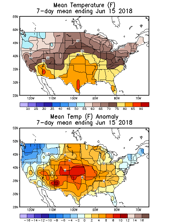
The period below, was used for the EIA number. That's a pretty big (bearish #) injection considering the amount of heat we experienced. ..........though the intense heat was not in the high population centers of the East, Southeast and Midwest.
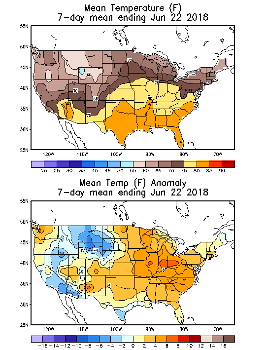
The period below and temperatures will be used for the next weekly EIA number released this Thursday at 9:30am CDT:
WxFollowers comprehensive analysis of the last weeks EIA number compared to previous years:
By WxFollower - June 21, 2018, 6:29 p.m.
"On a CDD equivalent basis at this time of year, a +84 would be:
- ~20-25 more bearish than 2017 and 2016, both of which had far more storage
- pretty comparable to 2015 and 2013
- ~20-25 more bullish than 2014, which at the time was having a very long string of 100+ injections
Based on the above, I'd call a +84 ~4-5 bcf looser than the average supply/demand balance of the last 5 years near the same time of year (late spring/early summer). Assuming about the same # of CDDs/HDDs for the next 21 weeks as the average CDDs/HDDs of the last 5 years and considering the current 507 bcf deficit to the 5 year average, the next 21 weeks will need to average 24 bcf/week larger than the 5 year average to get 11/2/18 storage to the 5 year average. So, the current supply/demand balance is nowhere near that."
--------------------------------------------------------------------------------------------------
June 22, 2018 below:
TODAY'S UPDATE: The actual was +91 rather than +84. Mike win this week with his +87 vs my +86. Congrats!
Now, I'm going to take what I wrote yesterday in relation to the average DJ guess of +84 and modify it to reflect on a +91 instead:
On a CDD equivalent basis at this time of year, the +91 is:
- Around 27-32 more bearish than 2017 and 2016, both of which had far more storage
- Around 7 more bearish than 2015 and 2013
- Around 13-18 more bullish than 2014, which at the time was having a very long string of 100+ injections
Based on the above, I'm calling the +91 about 11-12 bcf looser than the average supply/demand balance of the last 5 years near the same time of year (late spring/early summer).
With the bearish +91, the deficit vs the 5 year average shrunk slightly from 507 to 499. There are now 20 weeks to get to 11/2/18. Considering the current 499 deficit to the 5 year average, the next 20 weeks will need to average 25 bcf/week larger than the 5 year average to get 11/2/18 storage to the 5 year average. So, assuming near the 5 year average for weather, the current supply/demand balance, even just based on today's bearish report, alone, is still nowhere near that as 11/2/18 would come in near 270 lower than the 5 year average or near 3,559. That would actually be slightly lower than the 5 year minimum of 3,582.
Held put until today , the last day. Net 120 loss. Was expecting the 289 level to be taken out.
It NOW appears HEAT returning. Since ng may revisit the 300-305 level, I will wait before initiating a new short.
TRADE WELL
MetMike--as always, I appreciate the weather updates, as they supplement my tech studies.
tjc,
I have tremendous respect for your technical analysis and dial it into my thinking when looking at markets and considering personal trades.
We are fortunate to have you sharing it and your trades here. Same thing with the opinions/work of our other regular and some times not so regular contributors.
Thanks Much!
I think that there are loads of people who read stuff here and enjoy it but don't feel their contribution would add anything..........not so.
The market psychology is made up of a composite of many thousands of opinions. Some of them are wrong, some are right.
metmike and tjc are sometimes wrong about where the markets are going, even if 90% of our analysis is right on the money.
If the China thing matters more than everything else(in grains)......our analysis, absent the China thing doesn't matter.
If the funds are piling on the shorts, selling 10's of thousands of contracts/day....no matter what and don't care about our great analysis, our analysis will lose money.
So please provide your opinions, especially if they disagree with ours!
Help keep us tuned into the overall picture.
By metmike - June 26, 2018, 10:40 a.m.
The extended guidance/tools that the NWS will use this afternoon is turning MUCH drier and hot.
Temperatures below for today's 8-14 day forecast.
Precip Below for today's 8-14 day forecast:
As expected the NWS forecast just out mid afternoon, came out hot and getting drier:
Temperature Probability 6-10 Day |
Precipitation Probability |
Temperature Probability 8-14 Day |
Precipitation Probability |
Extreme weather days 3-7:

Extreme weather days 8-14:
