Most weather maps on MarketForum are updated constantly, from radar images every few minutes to daily precip/models. This causes my descriptions of some of the maps(which only comes out with the initial post) to be outdated later on or the next day. Every day, we just start over again with new descriptions and new maps. Please enjoy the comprehensive coverage of your weather here!
High Temperatures today and Friday......cool in the Northeast. Blast furnace heat in S.Plains .........getting ready to move northeast.


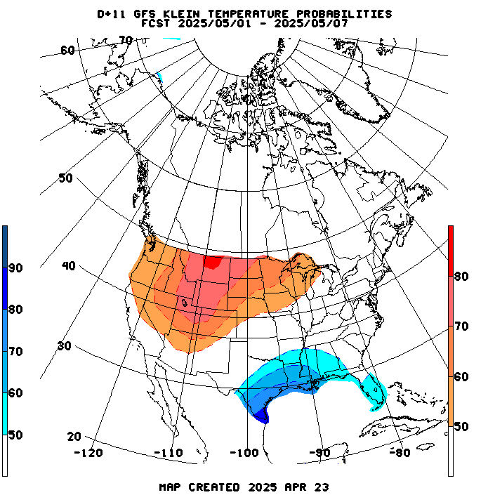
Highs days 3-7 shows Heat!


How do these temperatures compare to average at this time of year:
High temperature departures:

Low Temperature Departures:

From the GFS ensemble mean products. Temperature anomalies for this coming weekend..........record heat Northeast..............cooling N.Plains.
NCEP Ensemble t = 096 hour forecast 
Temperature anomalies at the end of week 2.....most intense heat shifted west? At least on the GFS ensembles but not all models.

But the European model is MUCH different and bullish with the heat ridge farther east:
CFS week 3 and 4...........HOT week 3, turning cooler week 4 and drier thru the period.

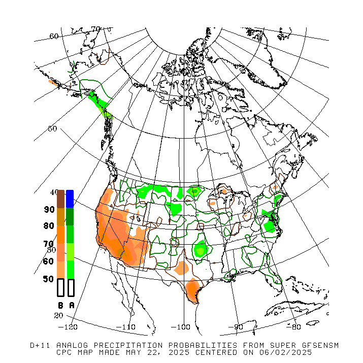
Precip below
NWS guidance for 8-14 day forecast for this afternoon(sneak peak at what it will show)
Precip below:
Here is the latest radar image. 
Here is the latest radar image.
Satellite picture.

Rains the past 24 hours...... not as much as recent days.
![]()
Most importantly........forecast rains.
Rains the next 7 days ......... Not like a broken record any more pattern is starting to change...........rains getting skinnier.
Day 1:
http://www.wpc.ncep.noaa.gov/qpf/fill_94qwbg.gif?1526306199054
Day 2:
http://www.wpc.ncep.noaa.gov/qpf/fill_98qwbg.gif?1528293750112
Day 3:
http://www.wpc.ncep.noaa.gov/qpf/fill_99qwbg.gif?1528293842764
Days 4-5:
http://www.wpc.ncep.noaa.gov/qpf/95ep48iwbg_fill.gif?1526306162
Days 6-7:
http://www.wpc.ncep.noaa.gov/qpf/97ep48iwbg_fill.gif?1526306162
Total accumulation
http://www.wpc.ncep.noaa.gov/qpf/p168i.gif?1526397762
Excessive rain potential. Hit the map for full screen.
http://www.wpc.ncep.noaa.gov/qpf/excess_rain.shtml
Current Day 1 Forecast Valid 15Z 06/11/18 - 12Z 06/12/18 |
Day 1 Threat Area in Text Format
| Day 2 and Day 3 Forecasts |
Current Day 2 Forecast Valid 12Z 06/12/18 - 12Z 06/13/18 |
Day 2 Threat Area in Text Format
Current Day 3 Forecast |
Severe Storm Risk. Push your cursor on the map for full screen.
https://www.spc.noaa.gov/products/outlook/
Current Day 1 Outlook | Forecaster: Hart/Kerr Issued: 18/1240Z Valid: 18/1300Z - 19/1200Z Forecast Risk of Severe Storms: Slight Risk |
Current Day 2 Outlook | Forecaster: Bunting Issued: 18/0600Z Valid: 19/1200Z - 20/1200Z Forecast Risk of Severe Storms: Marginal Risk |
Current Day 3 Outlook | Forecaster: Bunting Issued: 18/0731Z Valid: 20/1200Z - 21/1200Z Forecast Risk of Severe Storms: Marginal Risk |
Current Day 4-8 Outlook |
So far, grains must 'feel' heat will be beneficial to dry wet areas with just enough precip to not affect crop. NG, after spiking, appears to have built in the heat.
Your thoughts?
As always, much appreciated.
My opinion is that grains are too close to the USDA report tomorrow to react to anything else at the moment.
Agree with Jim.
Even without the report coming up, the market has not been able to hold any overnight dome scare dead cat bounces.
Too wet, still too much rain coming, too much big fund selling, too bearish overall, for the week 2 hot/dry forecasts to inspire aggressive speculative buying that would almost always happen.
Soils are so wet right now that it makes it even tougher for a dome to move in and stay.
Hey Mike
We did get some rain to add to the 2" previously mentioned
From 1/2" to 1 1/4" depending on which farm
The rain really helped our drought stricken crops
Bracing ourselves for the heat
