Fantastic February to you!
Coldest blast in several years on the way!
Reasons to continue to keep being thankful here in 2021!
https://www.marketforum.com/forum/topic/45623/
NEW: COVID peaked 3 weeks ago!
https://www.marketforum.com/forum/topic/63690/
Scroll down and enjoy the latest comprehensive weather to the max...... occurring because of the natural physical laws in our atmosphere as life on this greening planet continues to enjoy the best weather/climate in at least 1,000 years(the last time that it was this warm) with the added bonus of extra beneficial CO2.
Most maps below will automatically update each day(not the snow map).
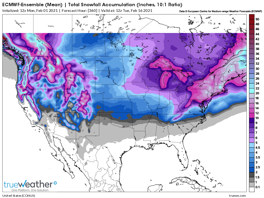
Total Snow for the next 2 weeks from the 12z Monday European Ensemble model.

Go to the link below, then hit the location/county on the map for details.
https://www.spc.noaa.gov/ Go to "hazards"
Here are the latest hazards across the country.
 |
Purple/Pink/blue on land is cold/Winter weather. Brown is wind, Green is flooding. Gray is fog. Reddish is a red flag advisory.
https://www.mesonet.org/index.php/weather/map/us_air_temperature/air_temperature

https://www.mesonet.org/index.php/weather/map/wind_chill_heat_index1/air_temperature

Current Weather Map
| NCEP Days 0-7 Forecast Loop | NCEP Short-Range Model Discussion | NCEP Day 3-7 Discussion |

Current Jet Stream

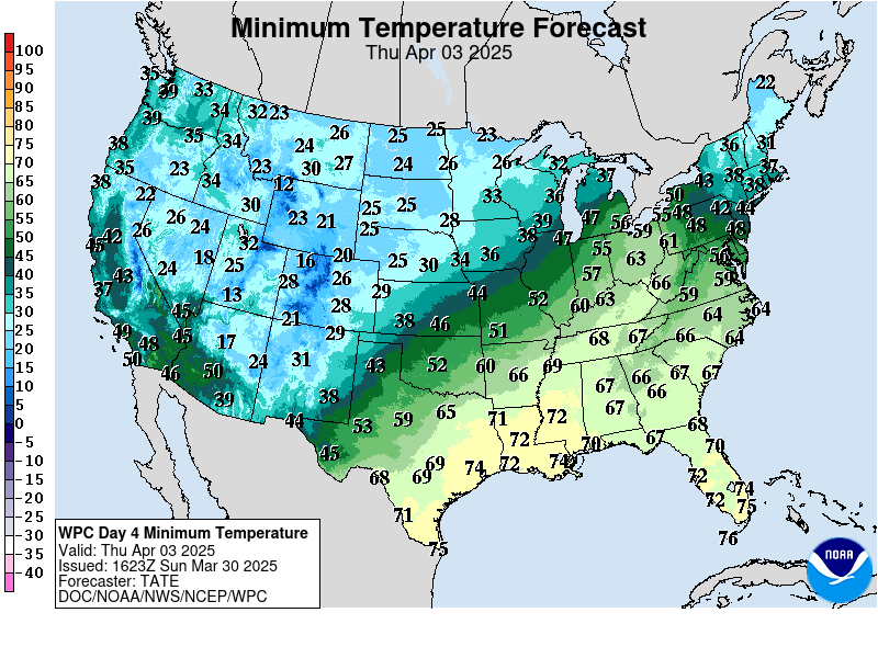
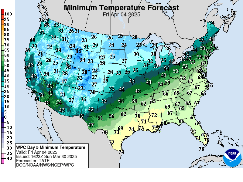
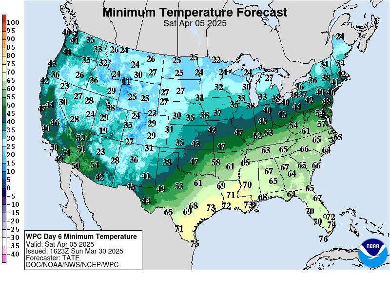
| Low Temperatures Tomorrow Morning |

Highs today and tomorrow.
Highs for days 3-7:
Bone chilling North/Central.......staying below zero even during the day next weekend!!


Lows days 3-7 below:
NorthCentral plunges into the DEEEEEEEP freeze late this week!!! MUCH below ZERO!
https://www.wpc.ncep.noaa.gov/medr/medr_min.shtml


Temperatures compared to Average for days 3-7
Waaaay below average NorthCentral!
https://www.wpc.ncep.noaa.gov/medr/medr_mean.shtml

Surface Weather features days 0-1-2 then days 3-7:
Nor'easter on Monday
Arctic BLAST drops out of Canada midweek, with a late week reinforcement
Arctic high pressure early next week
https://www.cpc.ncep.noaa.gov/products/forecasts/
Days 0-1-2 below:


Days 3-7 below:
Winter Weather info page from the NWS:
https://www.wpc.ncep.noaa.gov/wwd/winter_wx.shtml
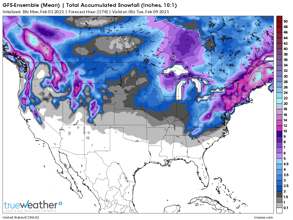
Total snow the next week from the 18z GFS Ensemble mean:
Liquid equivalent precip forecasts for the next 7 days are below.
Northern part of this will be snow!
Day 1 below
http://www.wpc.ncep.noaa.gov/qpf/fill_94qwbg.gif?1526306199054

Day 2 below:
http://www.wpc.ncep.noaa.gov/qpf/fill_98qwbg.gif?1528293750112

Day 3 below
http://www.wpc.ncep.noaa.gov/qpf/fill_99qwbg.gif?1528293842764

Days 4-5 below:
http://www.wpc.ncep.noaa.gov/qpf/95ep48iwbg_fill.gif?1526306162

Days 6-7 below:
http://www.wpc.ncep.noaa.gov/qpf/97ep48iwbg_fill.gif?1526306162

7 Day Total precipitation below:
https://www.wpc.ncep.noaa.gov/qpf/p168i.gif?1566925971

