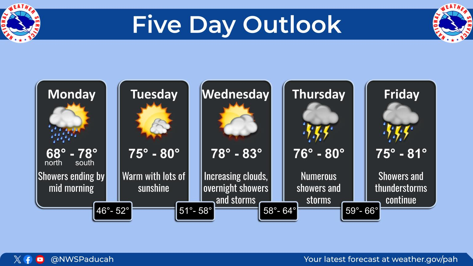
this is the forecast that i sent out earlier to several hundred parents and contacts in my chess program
scroll down to see the latest updates
+++++++++++++++++++++++++++++++++++++
an extended period of frozen precip is on the way.
when that happens, we would all prefer snow.....its not going to happen that way this time.
and it IS going to happen with certainty. its just a matter of what/when the IS is.
i apologize for the typing. i just had a left bicep distal tendon rupture repair and am using 1 finger.
the synopsis features very cold arctic air air near the surface....but that dense, colder air, hugging the ground, with north winds is undercutting the flow aloft that has a weak southerly component and an air mass slightly above freezing.
so the temp in the clouds, will, at times be above freezing as temps at the surface are below freezing most of the time. this is the recipe for a potpourri of frozen precip.
we will continue in this environment for several days....into thursday morning....then get hit with a blast of bitter cold.....keeping the ice/snow from melting for several days after that. my guess is that school is over for this week....unless something changes a great deal.
heres what it looks like. keep in mind that temps will be close enough to 32 deg. f the next 2 days that a slight change could mean a different kind of precip.
the snow starts shortly/very late afternoon. mainly light, less than an inch overnight as it mixes with or turns to freezing rain.
road/ground temps are subfreezing so most untreated surfaces will get slick.
this lets up on tuesday but we may still have drizzle/freezing drizzle before a more potent wave approaches tue night. the warm air aloft ahead of that makes freezing rain the most likely element,...rain that freezes on the ground! this could mix with or turn to sleet, if the rain freezes before hitting the ground.
some colder air aloft mixes in on wednesday, which increases the chance for the freezing rain to mix with or turn to snow......as well as sleet. this continues wed night, with it gradually turning to all snow from the colder air and probably ending thursday....as north winds pick up and colder and colder air is driven in.
we wont hit a bottom for temps until sunday morning, when it could be close to zero.
meteorologist mike
my latest weather forecast:
https://www.marketforum.com/forum/topic/65392/
nws:
you might enjoy this one. hit MW at the top. on the next screen, on the left, hit observations or surface.or even upper air.
https://www.spc.noaa.gov/exper/mesoanalysis/
ps hopefully, we can have chess at all 5 schools again next year with all the same tournaments. ill try to send some good chess links later.
+++++++++++++++++++++++++++++++++++++++++++++++++++++++++++
Mon 2/8/2021 11:28 PM
quick update:
tonight looks like mainly snow and very light.....1/2 inch or less. so we could have school on tuesday.
pretty quiet on tue/tue evening, except for possible light drizzle/fr drizzle.
very early wed morning is when the potential main problems begin....... light freezing rain that will coat many exposed areas with ice. could be sleet in there....if the rain freezes on the way down.
this may change to light snow on wednesday and continue wed night..........nothing heavy..maybe just an inch.
snow chances drop on thursday but north winds pick up and make it feel much colder.
very cold into the middle of next week. the high on sunday will only be in the teens. lows then and early next week could approach 0. there should be some moderation during the last week of february.
get the hourly weather forecast here:
| Hourly Weather Forecast for 38.04N 87.57W Point Forecast: 2 Miles WSW Evansville Regional Airport IN 38.04N 87.57W: Last Update: 5:43 am CST Feb 2, 2021 forecast.weather.gov |
late tuesday
the cold air is getting pretty entrenched so the deeper moisture has been shoved farther south. with this next system being a weak upper level system, look for amounts the next 2 days to be VERY light.
not so sure that school will be cancelled the next 3 days but it may be cancelled on wednesday, just because of the forecast.
the biggest deal with absolute certainty in the forecast is the bitter cold this weekend/early next week. down near 0 on monday morning. Fortunately, its president's day so no school any way on monday.
a potentially much stronger storm may take aim on this part of the country next mon night/tuesday, with a foot of snow possible northwest of its track.
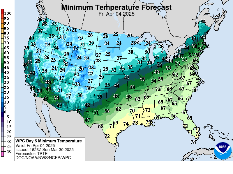
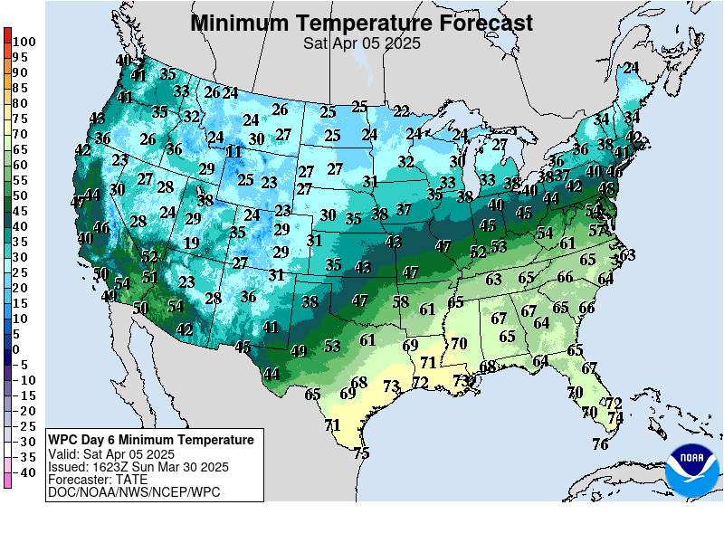
i included some forecast graphics below to help you to see whats coming up.
https://www.wpc.ncep.noaa.gov/medr/medr_min.shtml
https://www.wpc.ncep.noaa.gov/medr/medr_min.shtml


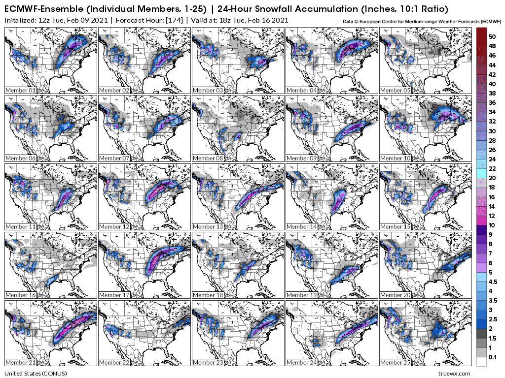
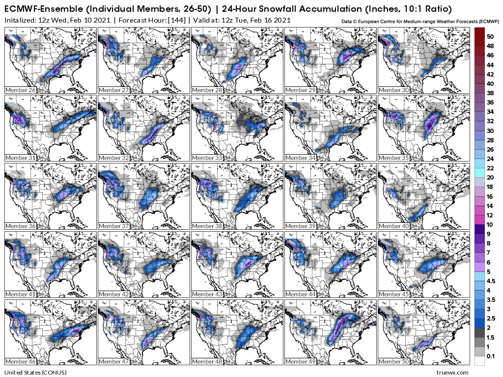
below are the different individual model forecasts from the 12z european ensemble for the snow amounts with the winter storm early next week. huge disparity in track and amounts. the bright pink is 10+ inches. Several solutions have evansville in, close to, or in the pink shade. a few have close to no snow. stay tuned.
wed pm update...it's here. be careful now as all untreated exposed surfaces will become extremely slick. with the amount of low level cold, much of this could freeze BEFORE reaching the ground.....sleet. sleet is way more preferred than fr rain. freezing rain coated surfaces are like an ice rink..sleet is not much worse than snow.
meteorologist mike
https://www.spc.noaa.gov/products/md/md0067.html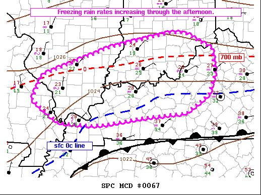
https://www.spc.noaa.gov/exper/mesoanalysis/
hit mw for our region. go to observations
focusing on the bright side:
The Best Board Games of the Ancient World....chess!!!
https://www.marketforum.com/forum/topic/65482/
how to make the world a better place
https://www.marketforum.com/forum/topic/64691/
quote of the day
https://www.marketforum.com/forum/topic/65056/
reasons to be grateful
i had a college class-mate from evansville indiana. leroy sumner. when i know him , we was a good decent guy. i don't think i ever met a better cards player. the kind of guy that could make money in vegas if he wanted to.
bear,
i knew a leroy (sumner) brown too but he was from chicago IL(-:
https://www.youtube.com/watch?v=prH8htiaXWg
+++++++++++++++++++++++++++++++++++++++++++++++++++++++
nws has upgraded their map to add a winter storm warning in evv.
| Paducah, KY - National Weather Service US Dept of Commerce National Oceanic and Atmospheric Administration National Weather Service Paducah, KY 8250 Kentucky Highway 3520 West Paducah, KY 42086-9762 www.weather.gov |
I actually suspect that we may change over to all snow later this afternoon.a wedge of colder air is likely to drop temps by a degree or so in the clouds and make it barely cold enough to change over to snow...close call. amounts will be an inch or less.
the BIG deal will be early next weeks huge winter storm.
the track will determine who gets a foot of snow.
the maps below from the latest models depict the potential snow amounts from next monday am to next tuesday am.
meteorologist mike
this is the latest computer forecast for next mon/tue...this graphic is updated constantly, so 12 hours from now, it will show a time frame below that is 12 hours farther out.
Fri 2/12/2021 1:20 AM
Greetings again chess families/faculty!
This week's icy weather looks like just a small sample of what lies ahead.
Over the weekend a frigid air mass will settle in with coldest air in over 2 years......lasting thru most of next week.
Then the real Winter action takes place. A major Winter storm with all snow will be taking aim at us on Monday. There's a potential for up to a foot on snow.
Then, on Thursday, another similar storm with amounts almost as heavy takes aim on the same locations.
The storm tracks will determine who get the heaviest snow. There is plenty of uncertainty this far out but there WILL BE places from the S.Plains to the East Coast that see snowfall totals from the 2 big storms next week of well over a foot.
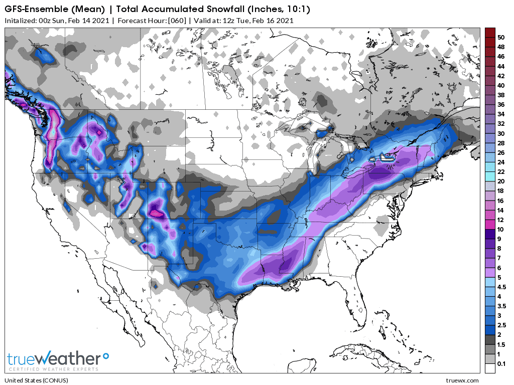
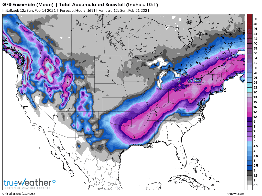
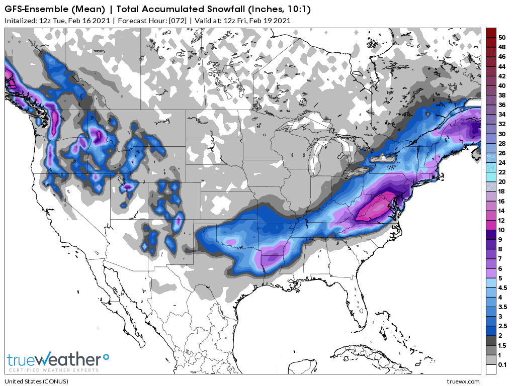
The latest GFS Ensemble mean, total snowfall map for the next week is below.
So that you are not constantly bombarded with forecast updates, I've created a thread at MarketForum, where I'm the moderator that will have the Evansville weather updates for at least the next week.
Updates may not be every day and may be more than once a day.
Meteorologist Mike
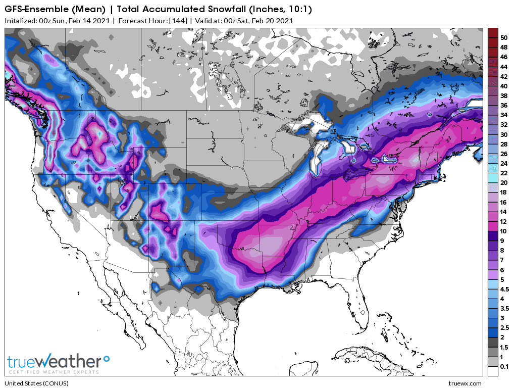
cumulative snowfall below from the Monday and Thursday snow totals. The pink shade represents 10+ inches.
Mike I could not get the image in your last post to open. Also what is the potential for drifting?
hi cutworm,
i reprinted the image so it should be good now.
great question on the drifting.
the first event will be very light, fluffy powdery snow vs the typical wet/heavy snow so it wont take as much wind to make big drifts.
We often hear that 1 inch of rain would make 10 inches of snow.
However, the amount of snow/water equivalent varies tremendously with temperature.
1 inch of rain, at 50 deg. F for instance, would never make X amount of snow because if you cooled the air down to the point of it being snow, 32 deg. F, that same air mass could only hold half as much moisture/precipitable water in the same column of air.
On average, when the temperature is in the mid 20's, an inch of water might make 10 inches of snow.
The typical snow to rain/liquid equivalent for our really heavy, wet snows around here, when the temperature is close to freezing, might be something like 5 inches of snow/1 inch of liquid.
Temps will only be in the teens during the day on Monday.
I'll have to do some calculating but this might cause the snow/liquid equivalent to be something like 15+ to 1.
Winds may be gusting to 20 mph.
6 inches of snow under those conditions may pile up drifts of several feet.
SNOW TO LIQUID EQUIVALENT
https://www.theweatherprediction.com/habyhints/346/
In researching this topic more, looking for good explanations, I came across these wonderful sites:
THE ULTIMATE WEATHER EDUCATION WEBSITE
http://www.theweatherprediction.com/
Terms used by meteorologists, forecasters, weather observers, and in weather forecasts
Compiled from several sources
https://sites.google.com/site/bobbysweather/weather-terms
https://www.dtn.com/snow-to-liquid-ratios-how-are-they-calculated/
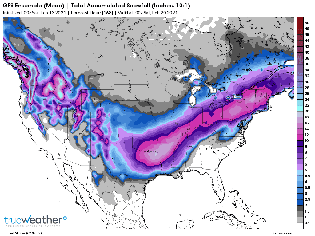
latest 12z GFS ensemble mean has increased the snow amounts slightly along the Ohio River. These are the cumulative totals from the Mon and the Thu storms.
We're in this one(s) together cutworm! (who lives in southeast IN)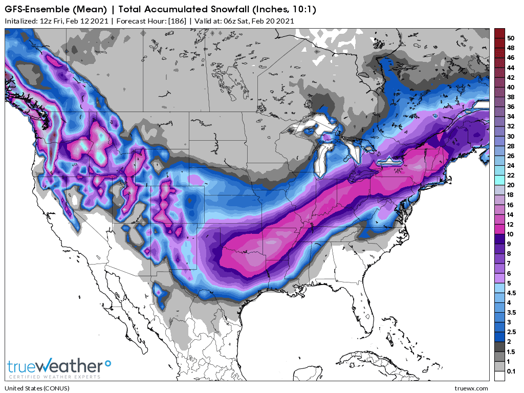
Snow totals for next week from the just out 0z GFS ensemble mean below. The pink shade is 10+ inches. A huge area. Some areas could actually total close to 20 inches with the right track of both storms.
Storm 1 is a Sunday Night/Monday event along the Ohio River with mostly a fluffy, light snow thats easily blown all over the place from winds gusting above 20 mph. Best guess on amounts is 6-7 inches right now.
Storm 2 is a late Wednesday/Thursday event with a heavier/wet snow that might add up to 6 inches. Winds will especially pick up on Thursday to 20+ mph but the wet snow will be tougher to blow around.
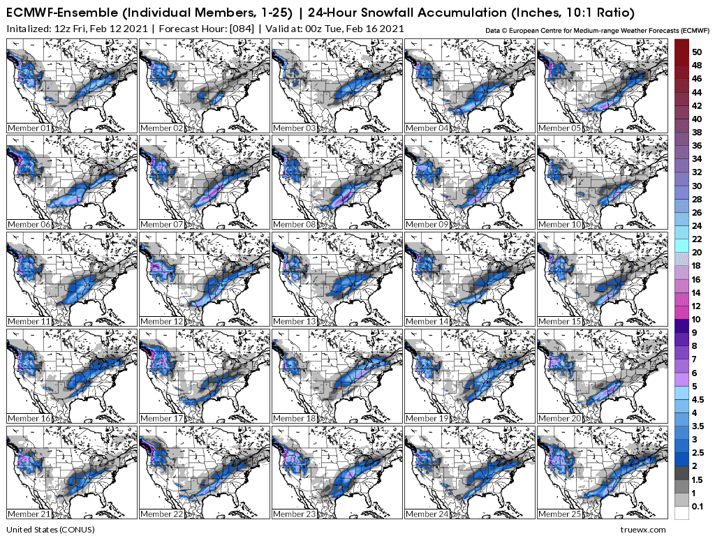
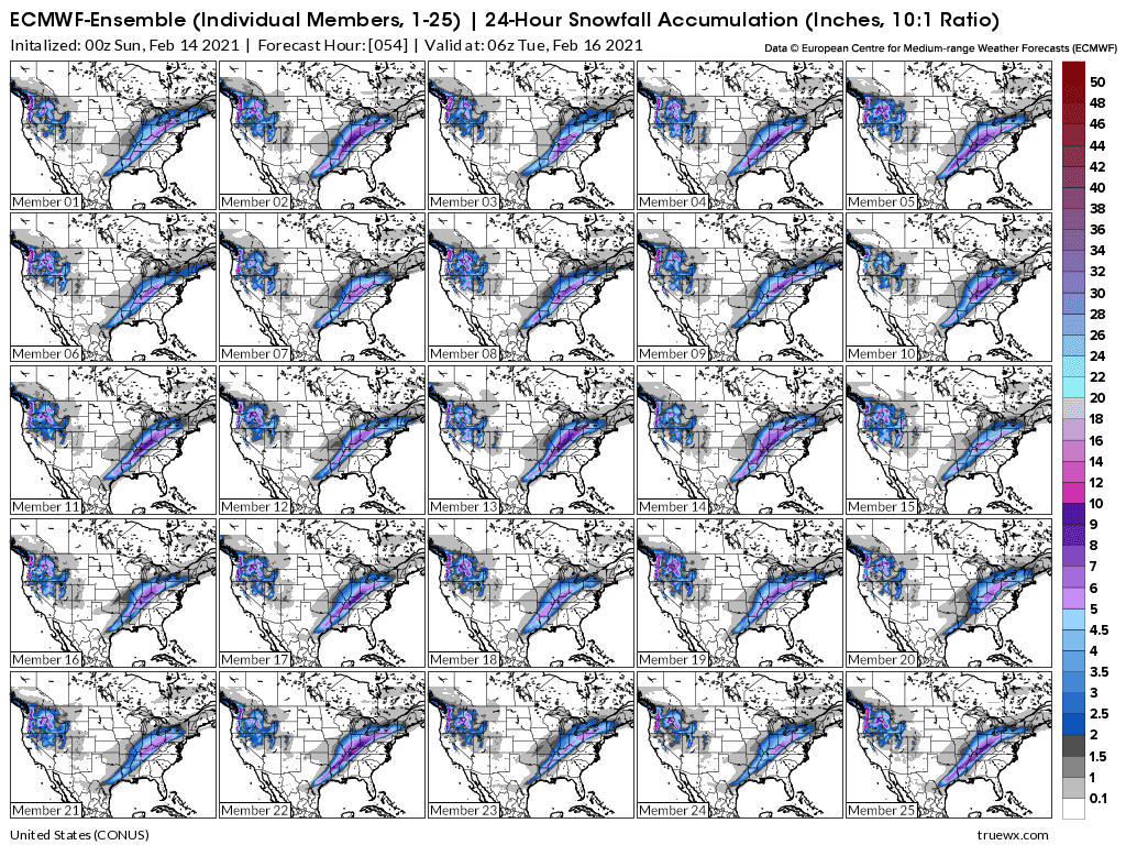
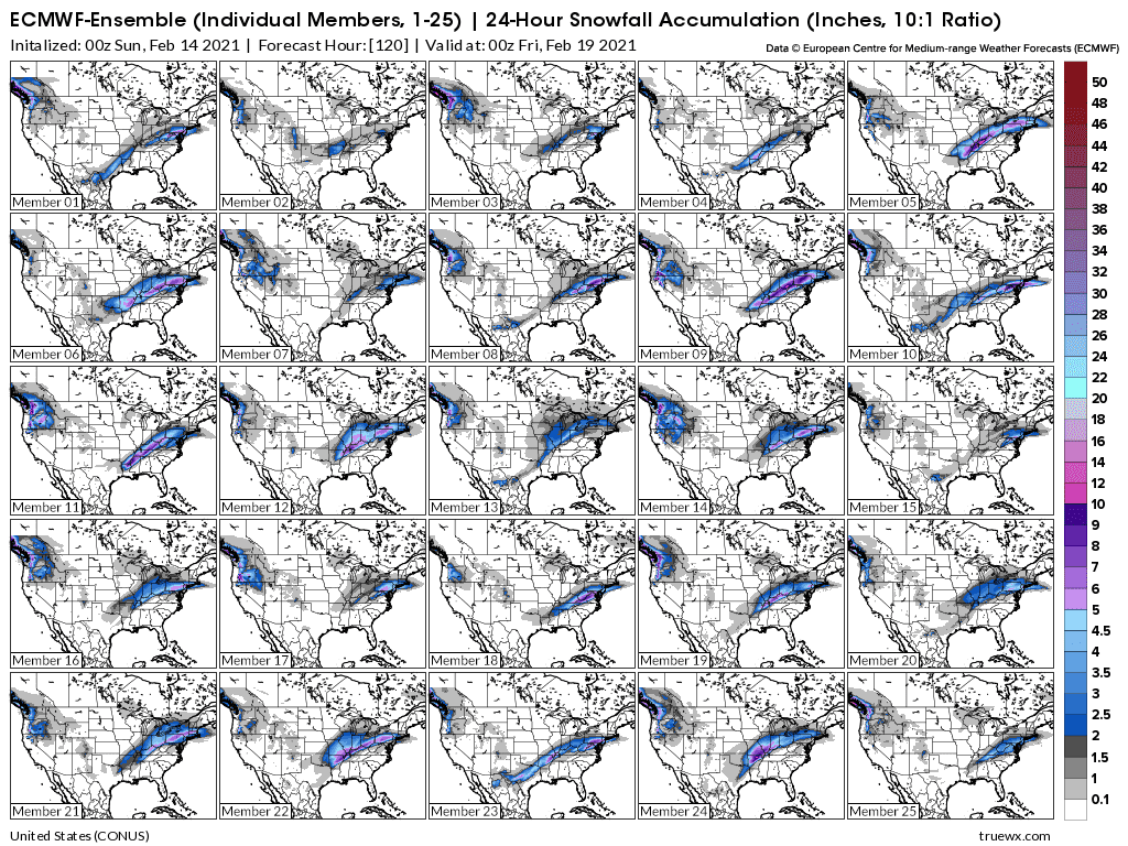
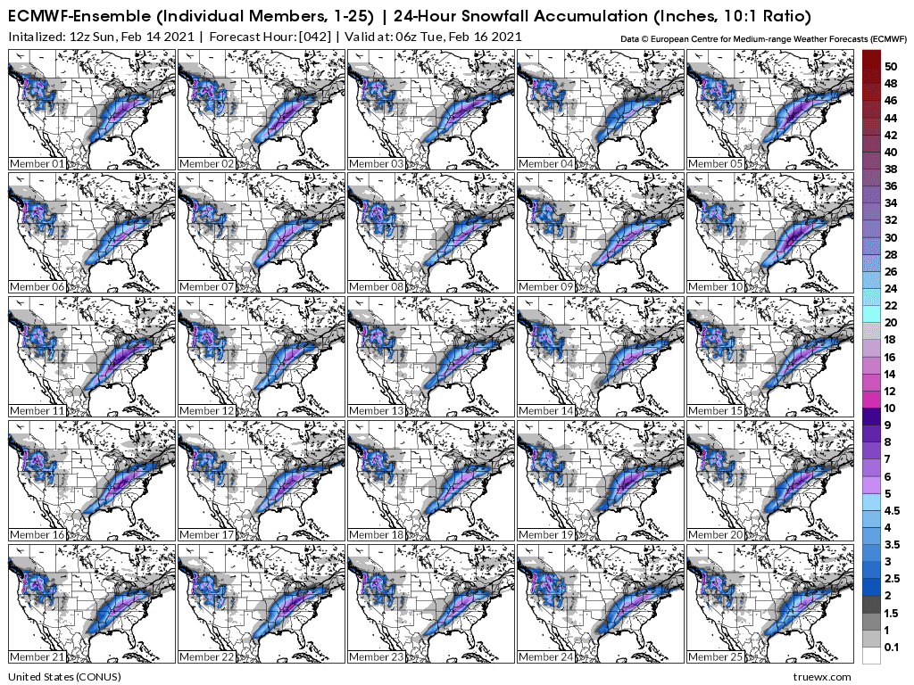
Storm 1 snow shield from the individual 12z European model solutions
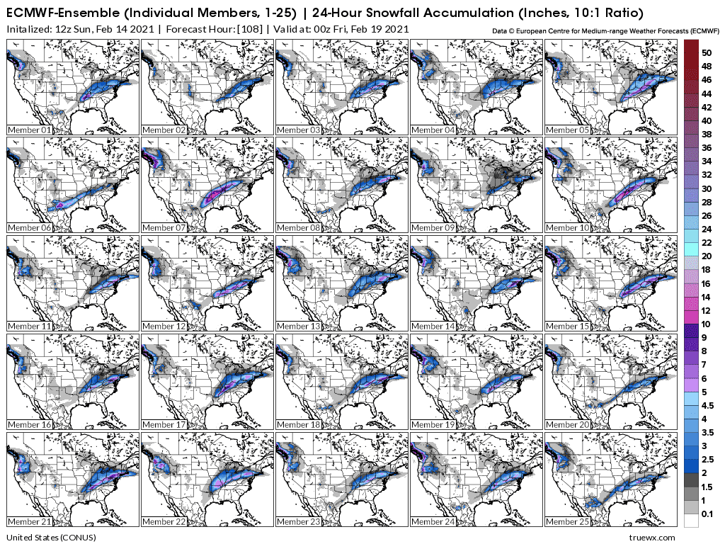
Storm 2 snow shield from the individual 12z European model solutions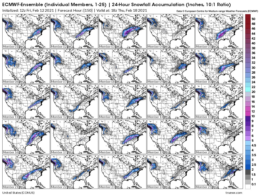
Keep scrolling down for the latest updates. Previous updates can be found by scrolling up.
The Winter Storm Watch , in dark blue below, should be upgraded to a warning on Sunday.
We might see around 7-8 inches of snow from this first event, with some blowing and drifting because it will be so fluffy as the result of how dry/cold the air will be. Heavier snows will be farther south and east.
The starting time is late Sunday and ending early Tuesday.
![]()
| 48-Hour Period Starting: |
| ||
|
Snow totals thru Tuesday morning from the latest 0z GFS ensemble mean.
Winter Weather specialists from the NWS:
Snow events 1 and 2 cumulative snow below from the GFS ensemble:
Snow from event 1 below, late Sunday thru early Tuesday. European ensemble model solutions:
Snow event 2 below from European model ensemble solutions. This snow will be a heavy/wet snow, possibly 6+ inches....from late Wednesday, thru Thursday.
| Thursday, February 18 at 5am |
There likely will NOT be any school next week..........not even on 1 day in the Evansville In area.
Not much change.
Several model solutions have a snow total for storm 1 at 8 inches.
They have storm 2 at 6-7 inches.
Those amounts could be much different, including almost 12" on some solutions for just the first storm below.
These are some of the solutions for storm 2, which on average produce LESS snow than storm 1.
Total Snow for this week from the 12z Sunday GFS Ensemble model.
February 14, weather
18 responses |
Started by metmike - Feb. 14, 2021, 1:07 p.m.
Here it comes!
Hit the play button at this link:
https://radar.weather.gov/?settings=v1_eyJhZ2VuZGEiOnsiaWQiOiJsb2NhbCIsImNlbnRlciI6Wy04OC43NzIsMzcuMDY4XSwiem9vbSI6NywiZmlsdGVyIjoiV1NSLTg4RCIsImxheWVyIjoiYnJlZl9yYXciLCJzdGF0aW9uIjoiS1BBSCIsInRyYW5zcGFyZW50Ijp0cnVlLCJhbGVydHNPdmVybGF5Ijp0cnVlLCJzdGF0aW9uSWNvbnNPdmVybGF5Ijp0cnVlfSwiYmFzZSI6InN0YW5kYXJkIiwiY291bnR5IjpmYWxzZSwiY3dhIjpmYWxzZSwic3RhdGUiOmZhbHNlLCJtZW51Ijp0cnVlLCJzaG9ydEZ1c2VkT25seSI6dHJ1ZX0%3D#/
Look for a couple/few inches of snow later tonight .............but snowfall rates may not pick up until late morning on Monday. Monday afternoon should feature the heaviest falling snow.
With winds picking up from the north/northeast to 20+ mph it will be the east/west direction roads that will see the biggest problems with blowing and drifting snow on Monday.
This large amounts of snow, with the very high snow to liquid equivalency of this snow event will be super, extraordinarily rare.
We could see a foot of snow. That has never happened before in Evansville recorded history with a temperature in the teens.
With the 2nd storm hitting Wednesday Night(maybe less snow) its unlikely that we will have any school this week.
With a ruptured left biceps tendon repair just over a week ago and rotator cuff surgery due on the right shoulder, this very fluffy type snow is going to make snow removal a possibility despite some physical limitations.....using a high powered gas leaf blower!
I'll let you know how well(or not) that it works.
Not much change to the forecast with the current storm.
As expected, heaviest snows continue to fall this afternoon.
Using the powerful leaf blower had some problems. Chemicals on the paved areas from the last ice event caused the snow to stick to the pavement. Also, any traffic that compacted the snow(shoe prints for instance) were tough to impossible to blow off).
The next event/storm is a certainty for this part of the country. However, many of the solutions on the European model below have most of the snow just southeast of Evansville.
We could get off with just a couple of inches...or even less but with a slight deviation/shift northward, those amounts would jump to 12 inches.
Many of the solutions on the GFS/American model have a foot of snow for Evansville.
Stay tuned.
This is the European model ensemble forecast that just came out for snow totals from late Wed. thru late Thu. Not much for Evansville.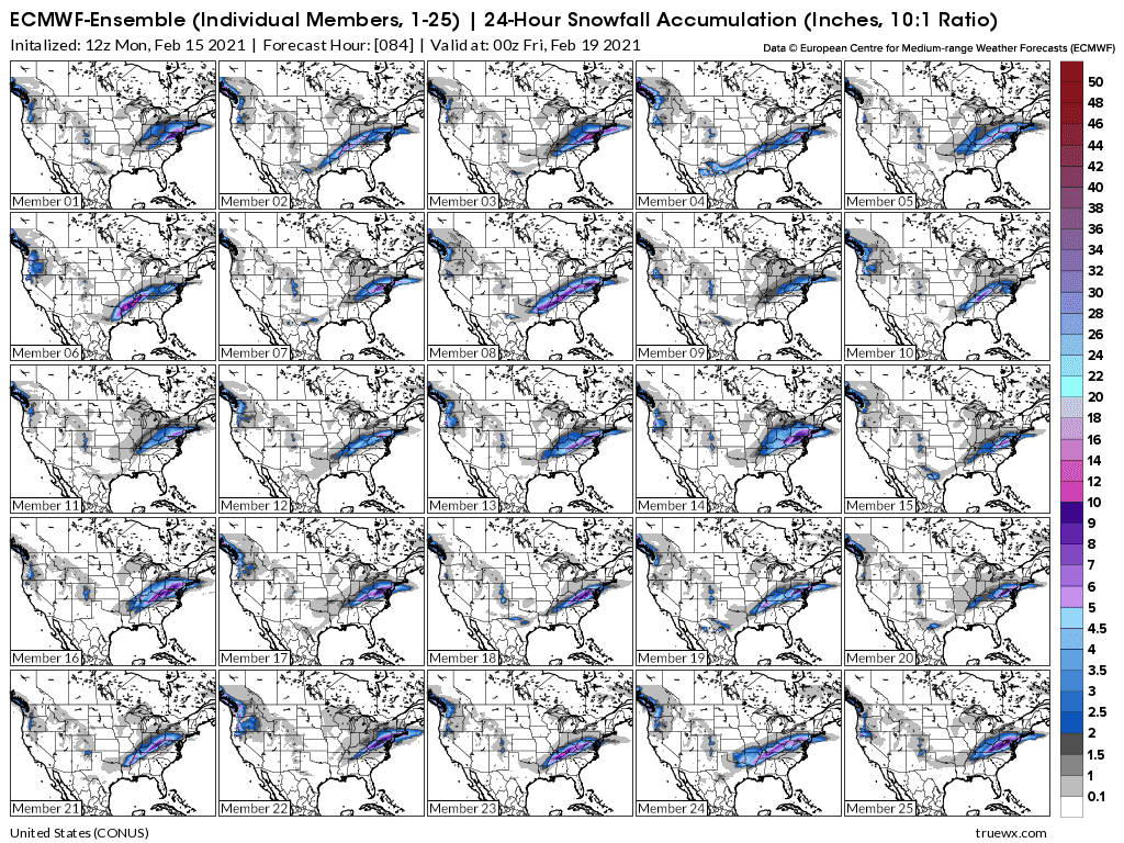
The European ensemble model from yesterday afternoon that dropped snow amounts for Evansville with this next storm looks like it Was first to pick up on a trend that has continued with additional model runs.
The last 6z model runs just out only have an inch of snow falling in Evansville with this next winter storm.
Let’s hope that doesn’t change!
Greetings snowbirds!
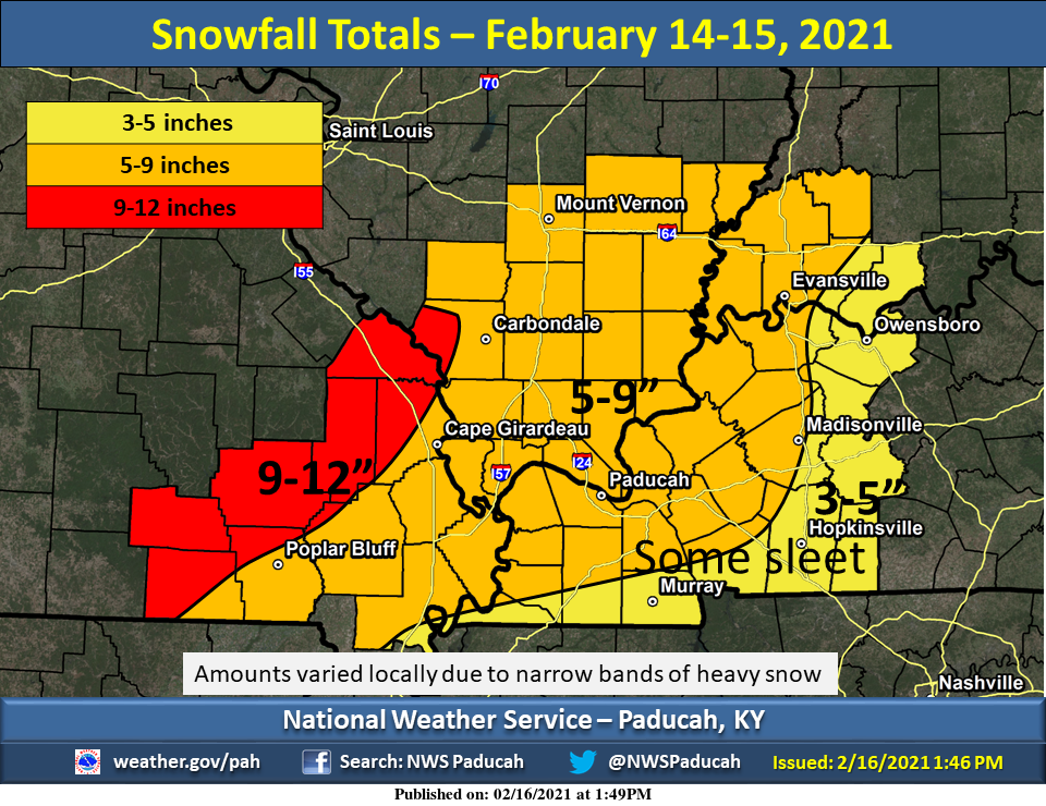
We measured 6.9" of snow in our backyard.
The NWS gives 3.5" for yesterday but that's messed up.
As mentioned with yesterday's afternoon update,
https://www.marketforum.com/forum/topic/65411/#65695
The 12z European Ensemble model was shifting the next storm farther south. The other models have fallen in line with that idea.
The next Winter storm track has gradually continued to shift farther south since then. This is the latest forecast for storm totals from the just updated 12z GFS.
Since we are right on the northern edge of a pretty steep snowfall forecast gradient, a miniscule shift in either direction could make a difference between getting an inch(if it continues to shift a bit more south) and getting up to 5 inches(if it shifted back north)
At this point, let's go with just 2 inches with the next storm and be prepared to adjust iit. The time frame is really stretched out from early afternoon Wednesday to late afternoon Thursday........so the intensity should be quite light. There could be some light freezing rain or sleet mixed in.
The best news is that we should finally get above freezing over the weekend but the anomalous snow pack, because of the latent heat of melting, will cause the process to gobble up alot of heat that would otherwise go directly into warming the air.
https://www.theweatherprediction.com/habyhints/19/
So instead of reaching 50 deg. F, we may stay 10 deg. F cooler until most of the snow is melted.
Meteorologist Mike
Get the latest updates here:
https://www.marketforum.com/forum/topic/65411/
Recent guidance continues to keep the next storm well south of Evansville.....then develop it more after it gets farther east.
Theres enough model agreement with snow totals....almost universal agreement in fact to go with around an inch total.
A Winter storm Watch is up for all areas 1 county south of the Ohio river.....none of them north of the Ohio river. Winter storm warnings are out for Tennessee.
The tight snowfall gradient means a small shift northward could increase snow amounts.
The high temperature on Tuesday was 17 degrees, which was 5 warmer than the record coldest higher temperature of 12 deg. F.
The low temperature was 1 degree, which was just 2 degrees from the record coldest of -1 deg. F.
Not quite records but still almost 30 degrees F BELOW the average.
No changes in my forecast philosophy, except the NWS has just updated the weather advisory and shifted it to around 25 miles north of Evansville, now including Evansville.
This is not unexpected, mainly from the event getting closer.
They are calling for up to 2 inches of snow and I can't disagree with that.
https://www.weather.gov/pah/weatherstory
The just out 12z GFS Ensemble mean total snow prediction from this storm is below. It has around 1.5 inches for us.
The snow should be over with well before noon. Looks like we got close to 2 inches.
The next 2 nights will drop into the single digits because of the fresh snowpack.
Gradual warming, starting on Saturday. Back close to freezing on Saturday with sun.
The only concern with the next one is if it came it 12 hours earlier on Sunday, which would put us at risk
for freezing drizzle early Sunday morning because ground temps are so cold. Otherwise, that one looks like rain.
Then, next week when it gets well into the 40's it will feel like Spring!
Without the snow melting process gobbling up alot of heat, we would see 50's but after much of the snow is melted, that should happen.