Advertised pattern change has started. Heat ridge backs up, rains in the water soaked central belt get skinnier and main Cornbelt drying out...........though not completely dry everywhere.
Forecast for rains below:
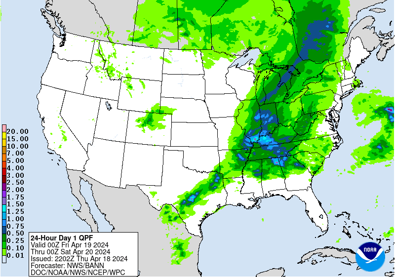
Day 1:
http://www.wpc.ncep.noaa.gov/qpf/fill_94qwbg.gif?1526306199054
 |
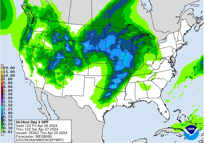
Day 2:
http://www.wpc.ncep.noaa.gov/qpf/fill_98qwbg.gif?1528293750112
 |
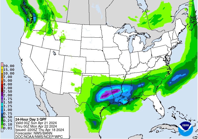
Day 3:
http://www.wpc.ncep.noaa.gov/qpf/fill_99qwbg.gif?1528293842764
 |
Days 4-5:
http://www.wpc.ncep.noaa.gov/qpf/95ep48iwbg_fill.gif?1526306162
Days 6-7:
http://www.wpc.ncep.noaa.gov/qpf/97ep48iwbg_fill.gif?1526306162
Days 4-5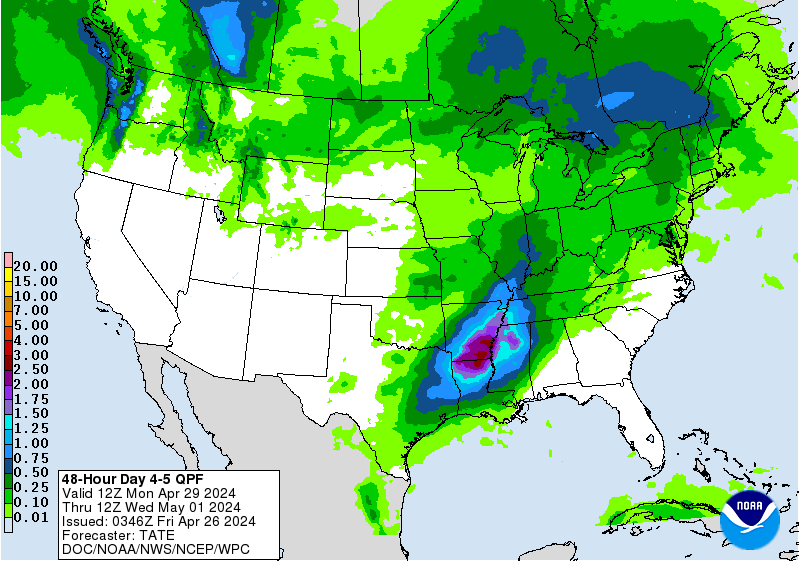 Valid 12z 07/06/18 - 12z 07/08/18 [contours only] | Days 6-7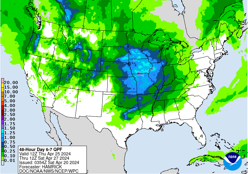 Valid 12z 07/08/18 - 12z 07/10/18 |
http://www.wpc.ncep.noaa.govcdx /qpf/p168i.gif?1530796126

Severe Storm Risk Friday.........or should we say NO severe storm risk. Main jet stream shifting north, not much risk. Press your cursor on the map for full screen.
https://www.spc.noaa.gov/products/outlook/
Current Day 1 Outlook | Forecaster: Hart/Kerr Issued: 18/1240Z Valid: 18/1300Z - 19/1200Z Forecast Risk of Severe Storms: Slight Risk |
Current Day 2 Outlook | Forecaster: Bunting Issued: 18/0600Z Valid: 19/1200Z - 20/1200Z Forecast Risk of Severe Storms: Marginal Risk |
Current Day 3 Outlook | Forecaster: Bunting Issued: 18/0731Z Valid: 20/1200Z - 21/1200Z Forecast Risk of Severe Storms: Marginal Risk |
Current Day 4-8 Outlook |
Current Day 1 Forecast Valid 12Z 07/05/18 - 12Z 07/06/18 |
Day 1 Threat Area in Text Format
| Day 2 and Day 3 Forecasts |
Current Day 2 Forecast Valid 12Z 07/06/18 - 12Z 07/07/18 |
Day 2 Threat Area in Text Format
Current Day 3 Forecast Valid 12Z 07/07/18 - 12Z 07/08/18 |
Most weather maps on MarketForum are updated constantly, from radar images every few minutes to daily precip/models. This causes descriptions of some of the maps to be outdated later on or the next day. Every day, we just start over again with new descriptions and new maps. Please enjoy the comprehensive coverage of your weather here!
High Temperatures today and Saturday.......pleasant in the Great Lakes/Northeast.


Much drier air Midwest to Northeast making it more comfortable.

Heat and high humidity in the south.....feels like temperature!

Highs days 3-7 shows Very warm/hot in most places.


How do these temperatures compare to average at this time of year:
High temperature departures:

Low Temperature Departures:

Last OVERNIGHT European model, heat ridge southern half of US heat flows into Midwest, especially southern Midwest:
Last, 6Z GFS is very bearish towards the end of week 2....heat ridge southwest and deep trough digs into Midwest.
gfs_namer_360_200_wnd_ht | gfs_namer_360_500_vort_ht |
gfs_namer_360_1000_500_thick | gfs_namer_360_850_temp_ht |
Same idea with Canadian model but a some members of the ensemble solution still bullish with dome farther northeast.
360h GZ 500 forecast valid on Jul 20, 2018 00 UTC


NWS guidance for 8-14 day forecast for this afternoon(sneak peak at what it will show). Very Warm across the country but hottest temps farther west........looking pretty dry across the central belt???
Precip below:
Satellite picture.

Rains the past 24 hours. IN/IL.........not much.
![]()
You can go to this link to see rain totals from recent time periods:
https://water.weather.gov/precip/
Go to precipitation, then scroll down to pick a time frame. Hit states to get the borders to see locations better. Under products, you can hit "observed" or "Percent of normal".


By Lacey - July 6, 2018, 8:43 a.m.
Great job metmike. Wish you were around when I was actively trading grains and energies.
Thanks Lacey!
CFS week 3 and 4. Heat out West...... but dry in the Cornbelt.
Precip below

The latest GFS is not that different from the last few solutions............which have been drying up the rains now for almost the last 2 weeks.
The main difference is that its no longer an extended 6-10/8-14 day dry forecast.........its now and goes thru that period.
The heat ridge is either south or west of the main cornbelt on most solutions but some still have it farther northeast, into the Cornbelt.
Last 12z GFS:
gfs_namer_360_200_wnd_ht | gfs_namer_360_500_vort_ht |
gfs_namer_360_1000_500_thick | gfs_namer_360_850_temp_ht |
Rainfall for 2 weeks......not much for Iowa:

Latest 12z Canadian model ensembles just out are MORE bullish. Several members have a massive dome over much of the Cornbelt............some don't but are still dry.
384h GZ 500 forecast valid on Jul 22, 2018 12 UTC


Forecasts for the control (GEM 0) and the 20 ensemble members (global model not available)
NWS extended forecasts have some interesting things. They have boosted the rains to normal, especially in the 6-10 day forecast vs much more below normal precip in the previous 13 days of this forecast's release.
They also have more heat in the Northeast than many of the models show:
Temperature Probability 6-10 day |
Precipitation Probability |
Temperature Probability 8-14 day |
Precipitation Probability |
Extreme weather days 3-7......heating for Central/Southern Midwest.

NWS week 3 and 4 forecast............Holy Cow, is that blue in the Midwest for temps????
This is consistent with the latest CFS week 3-4 forecasts.
Precip is dry from the S.Plains to S.Cornbelt.
Temperature Probability | Precipitation Probability (Experimental)  |
Well Mike
We just got saved, last night, with another 1"-2" rain depending on location and farm
Our corn was suffering and will start to tassel next week
Some spots are poking 1st tassel today
Of course with 2 dry spells and the some what less then needed rain [big time less rain than needed] our crops are not so even as they could be
However, a rain and then a cooler day today really helped, which was very welcome
I have no idea how much longer we will continue with just in time rain but our sub soil moisture is gone
However, this rain last night should allow me to deliver my forward contracted corn
It is hard to sell a crop when the seed is still in the bag
It's also hard to listen to all the gd/ex crops with well watered crops/soils and your crop is suffering big time
metmike afc weather with Dr crazy alias has multiple confirming signals with the big heat into the Midwest all the way to mid east by mid July...here locally we have already reached are normal amount of 90 degree days by the 4th
Wayne,
Happy to hear that you got another nice rain. It's been pretty hot up there for you guys.
mcfarm,
Do you have any of his stuff that you can share with us?
Can typhoon Maria affect our weather here in US about 2-3 weeks out?


![[contours only]](http://www.wpc.ncep.noaa.gov/qpf/95ep48iwbg.gif?1530626894)