I decided to elevate the radars and current conditions to the top because thats really the main thing that matters the most the next several days.
Latest radar and surface conditions, updated constantly:
In June, for the planted crop.
1. Rains make grain
2. Failed rains make for price gain.
3. On rare occasions(like this one)..........too much rain can damage grain
Latest radar images:
https://www.wunderground.com/maps/radar/current

This link below provides some great data. Hit the center of the box below for the area that you want, then go to observation on the far left, then surface observations to get constantly updated surface observations. Let us know how much rain you got/get!
 |
Current Conditions below updated every few minutes.
https://www.spc.noaa.gov/exper/mesoanalysis/new/viewsector.php?sector=13#


++++++++++++++++++++++++++++++++++++++++++++++++++
![]() xcessive rainfall results in saturated soils, ponding of water on the soil surface, or outright flooding of major agronomic crops somewhere in the U.S. Midwest every year. Individual growers and their consultants, however, may experience such crop damage only a few times in their careers and so often have little experience in assessing crop recovery or identifying economically viable crop management decisions in the aftermath of the damage.
xcessive rainfall results in saturated soils, ponding of water on the soil surface, or outright flooding of major agronomic crops somewhere in the U.S. Midwest every year. Individual growers and their consultants, however, may experience such crop damage only a few times in their careers and so often have little experience in assessing crop recovery or identifying economically viable crop management decisions in the aftermath of the damage.
This Web site offers a compilation of flood-related crop management information written by crop experts from throughout the U.S. Corn Belt. The articles are organized by subject area. You can either scroll down the page to locate an area of interest or click on the list below.
This is just one of the articles:
Assessing Flood Damage to Soybean
https://ipcm.wisc.edu/blog/2014/06/assessing-flood-damage-to-soybean-fact-sheet/
http://www.coolbean.info/library/documents/Flood_Damage_To_Soybean.pdf
Severe flooding has many low-lying soybean fields underwater. As the water dissipates yield potential and replant questions will arise. Flooding can be divided into either water-logging, where only the roots are flooded, or complete submergence where the entire plants are under water (VanToai et al., 2001). Water-logging is more common than complete submergence and is also less damaging. Soybeans can generally survive for 48 to 96 hours when completely submersed (Image 1). The actual time frame depends on air temperature, humidity, cloud cover, soil moisture conditions prior to flooding, and rate of soil drainage. Soybeans will survive longer when flooded under cool and cloudy conditions. Higher temperatures and sunshine will speed up plant respiration which depletes oxygen and increases carbon dioxide levels. If the soil was already saturated prior to flooding, soybean death will occur more quickly as slow soil drainage after flooding will prevent gas exchange between the rhizosphere and the air above the soil surface. Soybeans often do not fully recover from flooding injury
Once when I was trucking I came across a field of corn in full tassel. The field was low and close to a river. The river over flowed the banks and the corn was barely visible, due to upstream flooding.
I got unloaded, reloaded and the route back was past this same field. The wate had maybe 12 hrs since i saw it and the water was approx 1/2 gone. The thing I noticed was the thick layer of mud or dirt attached to the corn plants
I always wondered what happens when a crop is covered by flood water silt or soil carried by a river or similar. Perhaps a low spot in a field with soil erosion or any such situation that causes the plant to be covered with dirt/silt etc. That never happens around here so maybe somebody can enlighten me
I also wondered if up stream water was contaminated with toxic material that a water treatment plant might not be able to handle in a serious flood. I wondered if it would be possible if the corn kernels were covered in toxic material even if a small amount seeped into the husk surrounding the cob.
I would think crop insurance would be hard to come by if the land was in a flood prone area.
Just some questions about things that don't happen around here.
The most we get is if a 5" rain, we will have a low spot with standing water for maybe 24-48 hrs and then the tile take the water away. Have never seen water more than 8" deep and those places are tiled every 20', so the water is gone very quickly.
If we see flooding we get it tiled. Even wet spots can delay field work, thus tile is essential around here
We don't have hills and low spots plus no restrictions on tile work. Some fields even have land levellers to flatten out a high spot and fill in low spots. Usually done after wheat harvest on heavy clay that drains slowly.. We don't do that around here as the tile and sandy soil do our drainage work.
So severe flooding was new to me.
I have only seen a 5 " rain around here once that I remember. Most big rains are 2" or less. Less than 1" is most common. We might get more than 1 rain in a week which might add up to more than 2"
We could take a 2" rain this week end, the soil is so dry.
Thanks Wayne!
I'm not saying it will be super widespread flooding but when the models show a patter like I'm going to describe below, featuring a stalled pattern that repeats over the same areas more than once in a short period, you have the potential for excessive rains of 5+ in less than 5 days days over an area the size of a couple of states and you have the potential for isolated spots to get 10 inches of rain. More than isolated if you get training in a stalled area from just 1 event.
This is NOT a typical cold frontal passage event.
We have a massive heat ridge in the far Northwest. Then another heat ridge/Bermuda High in the W.Atlantic off the screen to the right.
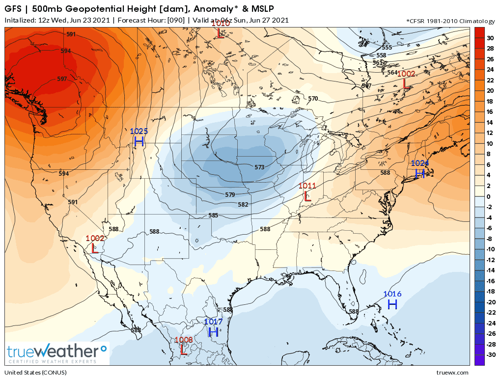
Trapped in between for several days is an unusually deep upper level trough. Here it is at 90 hours, very early Sunday with the 500 mb height contours.
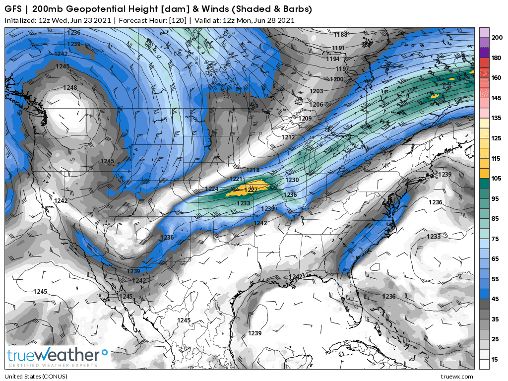
Below is the jet stream and what, in my mind elevates the potential for some extreme rains over the same area. Note the yellow area. This is a speed max of over 105 mph thats crossing the IA/MO border very early on Monday morning.
Because of the physics of the atmosphere there is a 100% chance that it will induce tremendous lift ahead of it. There is another one like it but not quite as pronounced that passes around 24 hours earlier over a similar area. If you look closely, you can see that the southern branch and northern branch of the jet stream are actually phasing together which is adding to the strength of the wave that this will induce along and above a stalled front at the surface(basically, a perturbation in the flow caused by the speed max's ability to lift the air ahead of it).
Impossible to exactly time this but I would say that we will have 2 massive rain events coinciding with the 2 well defined speed max's on the GFS model as described above and below. They will happen WELL AHEAD of the time frames on these maps because its their APPROACH that induces the atmospheric water fireworks. When the jet max actually hits........the weather it caused is long gone.
But what COULD happen, is that the first perturbation passing by may kick the lower level features favorable for moisture flowing up from the south.......farther to the south. and the next strong wave will cause the heavier rains to shift farther south.
And also, as the first one approaches, the upper levels could remain at sort of full throttle for a long time, with the lower levels at full throttle from the south with an accompanying low level jet maximizing the inflow of moisture and this actually is the period with the highest risk of training/repeat clusters of storms that keep developing from a sustained, extreme dynamic that results in them passing over the same area over and over. You can get a foot of rain in less than 12 hours when that happens.
The latest rain forecasts are below.
Day 1 below:
http://www.wpc.ncep.noaa.gov/qpf/fill_94qwbg.gif?1526306199054

Day 2 below:
http://www.wpc.ncep.noaa.gov/qpf/fill_98qwbg.gif?1528293750112

Day 3 below:
http://www.wpc.ncep.noaa.gov/qpf/fill_99qwbg.gif?1528293842764

Days 4-5 below:
http://www.wpc.ncep.noaa.gov/qpf/95ep48iwbg_fill.gif?1526306162

Days 6-7 below:
http://www.wpc.ncep.noaa.gov/qpf/97ep48iwbg_fill.gif?1526306162

7 Day Total precipitation below:
http://www.wpc.ncep.noaa.govcdx /qpf/p168i.gif?1530796126

The first of many flash flood watches for several states has been issued for much of Missouri. There will also likely be dozens of flash flood warning for individual counties in different states in the days ahead from late this week thru the weekend.
Just from a personal observation of the past.
Models will often predict the heaviest rains with events like this to be farther north than they actually happen.
Storms often erupt in the southern locations, then intercept/block the moisture needed to form storms farther to the north and the HEAVIER storms/rains never develop in the northern areas.
Not every time but for sure there is a bias for models to be too far north with the heaviest rains, especially when we have the southern branch/subtropical branch involved like this.
Some NWS forecasters will know this bias and adjust for it. However, this is a very unusual set up for last June. I don't ever remember one quite like this(with the massive heat ridge in the far Northwest).
Heat ridges/Bermuda High's along the East Coast and a blocked pattern......lots of times but never the strongest heat ridge being in the northwest.
It's possible this could cause the pattern to be more progressive.
Our weather for cast shows smaller rains and less chances as the time comes closer
Tomorow is our best chance then drops way down
Was a solid 80-90 % chance of rain 5 days straight
Now 40 %
Not so good as we need rain
Never had enough all yr
Crops hanging in there but not the best
I am beginning to doubt tthis wide spread rain
Local rains in smaller areas is my uneducated guess just judging by past patterns
Wetter places get rain
Dry stays dry
Takes a huge disturbance to change weather patterns
A large area of highly productive places are dry
When 200 APH plus is dry, it takes a heck of a lot to replace those lost bu. I don't see much to replace lost production on normally high producing locations
Part of the Dakotas, MN, Ia has 200 plus APH. That is huge production most yrs
What will replace that production???
The market bounced back early this morning after focusing on the benefits to the rains in a drought with a selling exhaustion, then ahead of the potentially damaging excessive rains.............dialed back in some risk premium.
7 Day Total precipitation below:
http://www.wpc.ncep.noaa.govcdx /qpf/p168i.gif?1530796126
Excessive rain threat.
https://www.wpc.ncep.noaa.gov/qpf/excess_rain.shtml
Current Day 1 Forecast
Day 1 Threat Area in Text Format
Current Day 2 Forecast |

++++++++++++++++++++++++++++++++++++++++++++++++++++++
Severe Storm Risk.
https://www.spc.noaa.gov/products/outlook/
Current Day 1 Outlook | |
Current Day 2 Outlook | |
Current Day 3 Outlook | |
Current Day 4-8 Outlook |
Go to hazards at the link above
Maybe I am wrong but folks say a lot of that radar has no rain
The green and yellow that was coming our way is breaking up and looks like no rain. Just clouds over head
No matter I find it interesting when people talk about crops in their area
A lot of back door bias re: what they think the corn belt will yield
Some are best ever, some a total loss and every thing in between
Just an observation
For the record, today was the 1st day our corn showed signs of stress [leaves spiked]
If we get rain all will be good but today was our best chance
Mich looks to have got our rain if you believe the radar
Wayne,
The main event hasn't even started yet.
Rains continue to fall and benefit the crop but are very PROGRESSIVE, not stalled out,so amounts are not excessive.
Forecasted amounts went DOWN overnight.
MM
Not excessive is the word for this event
Green and yellow and red all over us
I drop so far and radar shows rain will disappear with very little green left which means
Radar is not showing correct amounts hitting the ground
High hopes of rain
Radar just showing clouds
Take that back Mike
We just started to get a drizzle as I type this
Now it stopped
Corn was spiking yesterday
Today is much cooler so corn is not spiking
Now for some rain instead of clouds
Our corn is in the process of deciding ear size
Pollination and later decides how many kernels develop
Not optimistic for large amount of rain but maybe tomorrow??
Large - any thing more than 1/10}
Wayne,
Let us know how much rain you’ve been getting.keep us posted. Amounts should go up for you.
Another inch here overnight. Those that replanted their wet holes wasted their time for the most part. Wish I could send you some rain, Wayne !
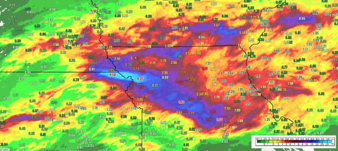
"Radar-estimated rainfall and 24 hour rainfall amounts for northern Missouri and nearby areas."
metmike: Very small area near 10 inches north of Kansas City.
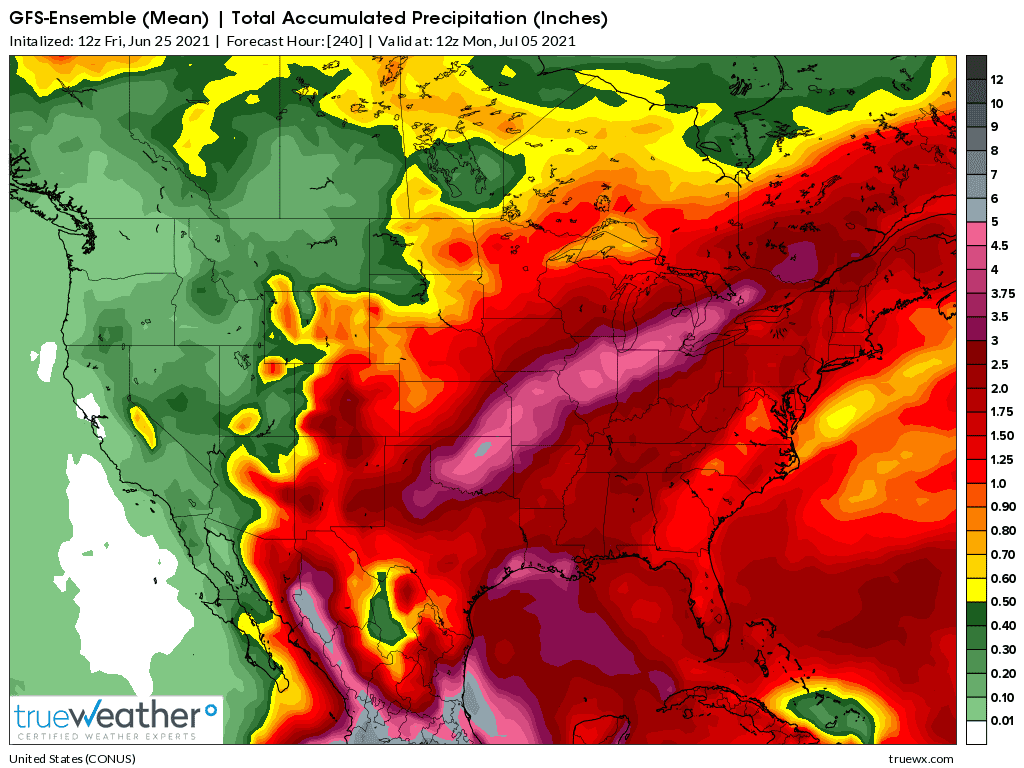
The just updated GFS Ens has nice rains but continues with less excessive amounts from this system...partly because of rain that already fell.
Even the 5 inch contour is gone.
Yesterday at this time, we had a 7 inch contour over IL.
Hi Mike
For all my complaints we have received approx 2/10" depending on which rain gauge I look at 7 P:M
Thanks for keeping us posted. Heavier rains continue to dry up over your area but hopefully much more on the way Wayne!
Here is sw Indiana, we went from a squishy/ saturated soil earlier this month to no rain for well over 2 weeks.
Most of the crops still look great but with strong winds blowing the last 2 days.....gusts to 30 mph some of the corn is rolling leaves in the pm hours.
We might be getting close to pollination next week in some of the early planted fields.
Excessive rain event in progress in numerous counties just south of Kansas City right now.
NWS Forecast Office Kansas City, MO
Weather.gov > Kansas City/Pleasant Hill, MO

reports of 15 inches in parts of Missouri
The drought is broken in our part of S.W Ontario
Sitting right at 4" 9:30 A.M
Includes 2/10 from yesterday so 4" in 24 hrs
Rained most of the nite until I fell asleep
We must have been dry as there is no standing water any where in our neighbourhood
Son and grandson pulled in this morning and took different routes coming here, did not see any standing water. Beans are small so standing water would be easy to see from the road
Even a 60 acre field on indian reserve we farm with no tile and many low spots has no standing water, so it must have been dry plus the rain came slow, but most of the nite [near as I can tell] to allow to soak in
Congrats Wayne!!!
This must have been the biggest one day rain event ever for you....correct?
Thanks mcfarm,
The risk for excessive rains is mostly over, other than in isolated places. The pattern has evolved a bit differently than expected too.
There was 10+ inches of rain in numerous counties of MO for totals the past 2 days. The models were originally targeting IL into IN as the epicenter for excessive rains.
mcfarmer, Looks like you were north of the better rains (-:
Hi
4" in 24 hrs is the most my son and grandson have ever seen. They were amazed at the lack of standing water
Normally a 2" rain is a big event around here with most less than 1 " I had a 5" rain in a short time frame, some yrs ago.. Did considerable soil erosion. Since then I bermed some soil. I can't stop the soil moving down hill, but I can keep it on my farm
I hope my family now sees the benefit of being prepared as best as possible for once or twice in a life time toad strangler
We are mostly flat with small knolls but do have a couple steep hills for a short distance
Our top soil is very thin so I want to keep it on my farm
Yes 4" is not normal for us
We received right at an inch over 24 hours. Not enough to coast very long but certainly significant.
My new seedlings had turned yellow and brown, I’m amazed how they can respond to a little rain and green back up.
Great mcfarmer,
Looking the amounts, I was worried it would be less than that....even though triple that amount would have been perfect.
Wayne,
We have thick, grey/light colored clay soils around here in sw Indiana. They hold water and dry out slowly.
I grew up in Detroit and had my own landscaping business when growing up. I did alot of weed pulling and did work with the soil and am very familiar with the loose/rich, very black fast draining soils up there that don't hold water well.
Growing up, I just assumed all soil was like that.
I became a massive gardener here in 1992 and immediately noticed the difference in soils.
Over the next several years, I collected a dozen pick up truck loads of sawdust and horse manure. Some I would mix into my huge garden, some I would have in piles off to the side to add later. I added extra nitrogen to the piles to get the carbon in the sawdust to compost faster. They would have steam coming off of them in cold weather.
Man, I had that garden with a perfect, amended soil.......then the wife wanted to move!
Anyway, I've had dozens of trips back to Detroit that involved me doing Dad's landscraping. WOW! I never realized(appreciated) how naturally awesome the soils are up there. Like potting soil compared to the thick soils down here that can turn to concrete if you work them and compact them when they are saturated.
In my uneducated opinion we seem to be getting into a more normal summer weather pattern. Previous to this things would develop in the west then die out, rather than build as I remember the case being.
Today clear skies and now thunder with a small cell to the west of me that is gaining strength.
update: pop-up shower gave us four tenths in about a half hour.
Glad to read that got a bit more very needed rain mcfarm.
The pattern coming up to start off July is a bit odd but and probably being affected by the La Nina signature in the Pacific.
Back to very warm and dry for the N/C Plains as well at the Upper Midwest, with better rain chances the farther southeast you go.
Upper level ridging looks to dominate the northern 1/3, somewhat similar to the recent pattern.
https://www.marketforum.com/forum/topic/71672/#71867
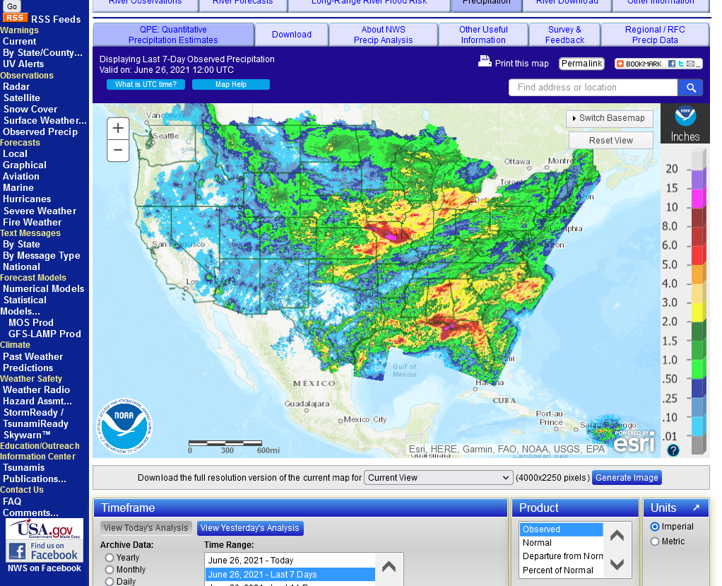
These are the rains over the last 7 days. Numerous counties in MO got over 10 inches of rain which did some damage.
Many dozens of counties got over 6 inches, some over 8 inches. Those higher amounts likely hurt the crops more than helped them but all those places should not need another rain for over 2 weeks now.
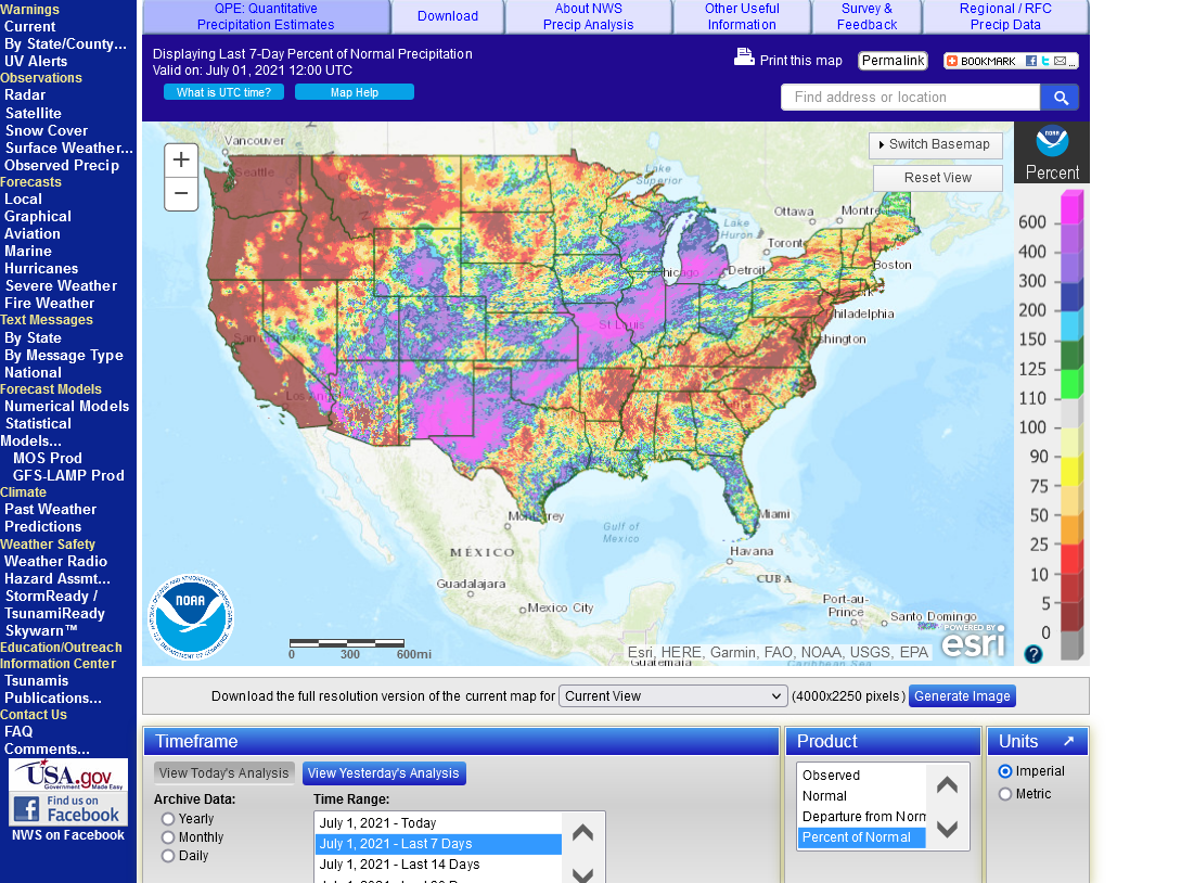
The 2nd map shows how astounding this rain event was. Over 6 times the average rain for the last 1 week period in a massive area of pink. WOW!
https://water.weather.gov/precip/

4out of 5 producers commenting here report damage from excessive rains this month............C.IN, S.IL, SE.IL and SW.Ontario but not in IA.
 Local Rad