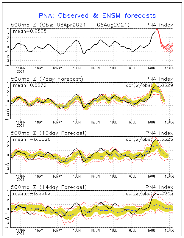
The GEFS runs of the last few days have been predicting an unusually strong +PNA coming up in early August. Yesterday’s run was stronger than Friday’s run and today’s run is even more impressive with a likely new record high +PNA peak (records back to 1950) (see below)!
Today’s PNA started the very sharp rise as has been forecasted by the GEFS for days although it didn’t quite reach 2 with it at 1.67 vs yesterday’s 0.51.
As mentioned, today’s GEFS PNA forecast peak is even higher than the last 3 days. It implies a higher chance to exceed the daily record high of 3.397 (records back to 1950), which was set on 9/24/2008)! Moreover, it suggests an even better chance to exceed the current record of two days at 3+ during one peak, which was set 9/23-24/2008.
Today’s GEFS suggests a good chance for it to exceed 3 tomorrow. It still has a slight fall for 8/3 and then near steady on 8/4 although both may barely remain at 3+ (will be close). Then, it still has a second rise, which is even more prominent than the prior forecasts. It has it easily above 3 on 8/5-6 with a new record high peak above 3.397 quite possibly being set on one or both days! It is suggesting over 3.5 on both days! Then it falls some on 8/7 although it may still be at 3+ for the last time. Afterward there is a sharp fall 8/8+.
So, today’s forecast suggests not just a good shot at a new record high peak but also a very good shot at a new record high # of days at 3+ with as many as six days during 8/2-7, which would absolutely obliterate the current record (back to 1950) of Sep of 2008’s two days at 3+!
Today’s GEFS PNA forecast:
I was about to add that graph that you added and had to skiddadle and am at the pool with the gkids.
I'm so glad you pointed this out larry. I often don't follow this as close in the summer and had no clue it was this extreme.
That is mind boggling.
I'll have more later. Thanks so much!
It was just earlier this year that we had an extremely impressive -AO index!
No doubt Larry remembers that one!
AO heading for sub -5 on Feb 11th!
7 responses |
Started by WxFollower - Feb. 9, 2021, 9:37 p.m.
Hi WX
For those of us who are not weather literate would you please put those numbers and location in layman's terminology
As it is, looks like you and MM have a private lingo I can't understand
My screen did not show most of the graph. I could make it smaller but can't read the small print.
Hi Wayne,
I don't know why it formats it that way. When I look at it on my phone, however, it looks fine.
Please start with this and see how it goes/feel free to ask questions.
PNA link:
Climate Prediction Center - Pacific/North American (PNA) (noaa.gov)
Maybe these links will help you out Wayne:
https://www.cpc.ncep.noaa.gov/products/precip/CWlink/pna/pna.shtml
https://www.cpc.ncep.noaa.gov/products/precip/CWlink/pna/pna.sprd2.gif

Here's more to help you understand it a bit more.
https://weatherworksinc.com/news/NAO-AO-PNA-EPO-explained

The PNA: Pacific / North American Pattern
The Pacific / North American Pattern, or PNA describes the orientation of troughs (dips) and ridges (bulges) in the jet stream from south of the Aleutian Islands (in Alaska) to the West Coast of the U.S. A positive PNA features a trough over the Aleutian Islands and ridge in the jet stream along the West Coast; a negative PNA, as seen in the image above, features a ridge south of the Aleutian Islands and trough on the West Coast. A positive PNA features colder weather east of the Great Plains, and in this instance the opposite is occurring.
metmike: The cool weather that you are experiencing in Ontario is connected with the extremely positive PNA right now.
When the PNA is strongly positive, there are usually move ridges along the West Coast and because of teleconnections(spacing between major features) in the atmosphere, that frequently correlates with troughs downstream in the Midwest. ........and cooler temperatures there.
The pattern is predicted to change in a big way during the next week, with the PNA crashing much lower to near 0. .........so the heat in the West will be kicked eastward.........where more people live......which has been bullish for NG this week.
Later in week 2, the ridge may rebuild along the West Coast.
Tks
The links showed up perfectly and I am able to understand [I think]
Yesterday (8/5/21), the PNA was at an amazing 3.73, which obliterates the old record high going back to 1950 of 3.397, set on 9/24/2008! The GEFS suggests there will be one more very high day tomorrow:

Thanks much Larry!
Non weather experts will not truly appreciate something like this but it's pretty incredible.
You can thank it for being part of the pattern that resulted in the cool temps here in the Midwest this week. (strong ridge West/trough downstream-Midwest)
With regards to what caused this?
Look at the mind boggling blob of warm water anomalies in the N.Pacific ocean right now.(with a near La Nina cool water signature in the East Tropical Pacific)!

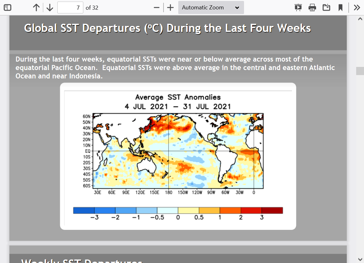
In my opinion, we have a La Nina type "signature" in the Pacific right now, which is forcing the atmosphere to act like a full fledged La Nina.
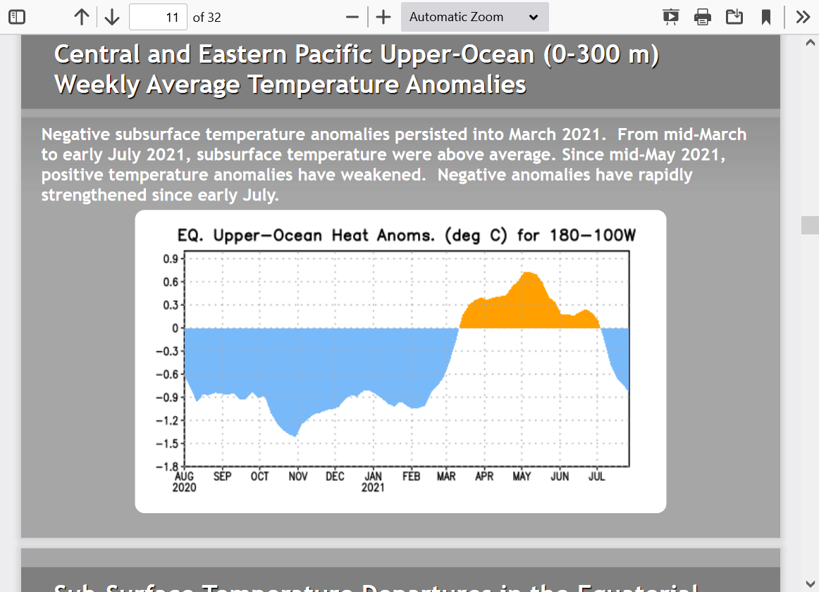
Models see additional cooling of the anomalies in the key measuring location of the East/Central tropical Pacific as the year goes on, which would strengthen that signature and put us back into an OFFICIAL La Nina again.
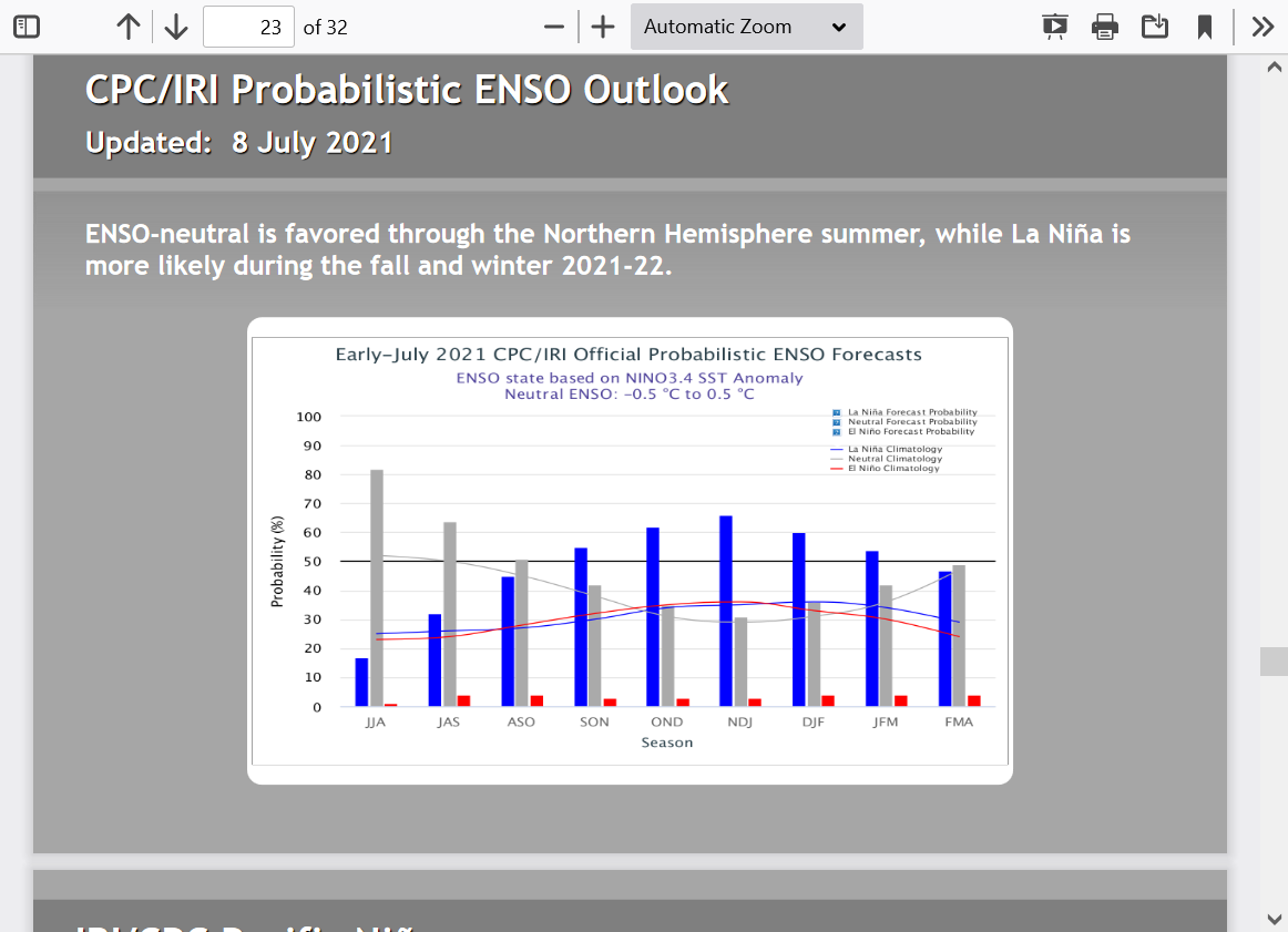
This makes sense with subsurface waters cooling again.............which should lead to cooling surface waters.
We are referring to ANOMALIES, which are just a deviation from average......not absolute temperatures.
Absolute temperatures will always warm in the Summer and cool in the Winter.
Unfortunately, this increases the chances for the drought to continue!
Aug/Sep/Oct forecast below
https://www.cpc.ncep.noaa.gov/products/predictions/90day/


August forecast


Thanks, Mike!
We got an even higher PNA of 4.00 today (smack dab at the top of the chart), which absolutely obliterates the previous all-time old record peak for any date back to 1950 of 3.40!! This also makes it three days of 3+ for this event, which breaks the previous record of two days in 2008 and we may even get one more tomorrow:
I have noticed that despite this record high PNA today, the 500 mb pattern today doesn't look nearly as impressive to the eye as prior days. To be sure, the W NA ridge/E NA trof was quite impressive for summer/most impressive to me on August 2, when the PNA was "only" at 2.88:
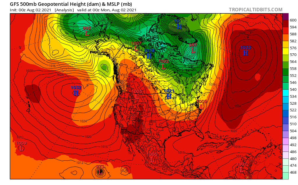
However, today's H5 (500 mb pattern) on the day of the PNA peak is already much flatter:

It is almost as if there's a lag in the daily PNA calculation. So, nothing is showing up of note now at h5 but it was showing up impressively a few days ago.
Thanks Larry!
Even more impressive.
Today, we got one last 3+ with a 3.40. That makes four 3+ days in a row. This is amazing because during the prior 71 years, there was only one time that there were as many as two days in a row! So, this event is by far the greatest +PNA in the 71 years of recorded history. Could this have been a once in several hundred+ year event? Quite possibly.
Thanks for keeping us posted on this amazing event Larry!
This is what it looks like in the rear view mirror!
https://www.cpc.ncep.noaa.gov/products/precip/CWlink/pna/pna.sprd2.gif