From Weather Sunday:
By metmike - July 15, 2018, 10:50 a.m.
Satellite picture....................from satellite in geostationary orbit. More on geostationary orbit later.......today:

https://earthobservatory.nasa.gov/Features/OrbitsCatalog/page2.php
"When a satellite reaches exactly 42,164 kilometers from the center of the Earth (about 36,000 kilometers from Earth’s surface), it enters a sort of “sweet spot” in which its orbit matches Earth’s rotation. Because the satellite orbits at the same speed that the Earth is turning, the satellite seems to stay in place over a single longitude, though it may drift north to south. This special, high Earth orbit is called geosynchronous.
A satellite in a circular geosynchronous orbit directly over the equator (eccentricity and inclination at zero) will have a geostationary orbit that does not move at all relative to the ground. It is always directly over the same place on the Earth’s surface.
A geostationary orbit is extremely valuable for weather monitoring because satellites in this orbit provide a constant view of the same surface area. When you log into your favorite weather web site and look at the satellite view of your hometown, the image you are seeing comes from a satellite in geostationary orbit. Every few minutes, geostationary satellites like the Geostationary Operational Environmental Satellite (GOES) satellites send information about clouds, water vapor, and wind, and this near-constant stream of information serves as the basis for most weather monitoring and forecasting.
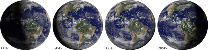
Satellites in geostationary orbit rotate with the Earth directly above the equator, continuously staying above the same spot. This position allows satellites to observe weather and other phenomena that vary on short timescales. (NASA images by Marit Jentoft-Nilsen and Robert Simmon.)
Because geostationary satellites are always over a single location, they can also be useful for communication (phones, television, radio). Built and launched by NASA and operated by the National Oceanic and Atmospheric Administration (NOAA), the GOES satellites provide a search and rescue beacon used to help locate ships and airplanes in distress.
Finally, many high Earth orbiting satellites monitor solar activity. The GOES satellites carry a large contingent of “space weather” instruments that take images of the Sun and track magnetic and radiation levels in space around them.
Other orbital “sweet spots,” just beyond high Earth orbit, are the Lagrange points. At the Lagrange points, the pull of gravity from the Earth cancels out the pull of gravity from the Sun. Anything placed at these points will feel equally pulled toward the Earth and the Sun and will revolve with the Earth around the Sun."