Scroll down to the bottom for the latest posts!
I'm creating this thread, Especially to provide updates for people living in the Evansville IN area that are in my chess programs at 5 schools, that include several hundred parents and teachers.
Rather than bombarding them with emails, they can just come to this link and get the latest updates.
However, the severe weather threat will obviously extend, geographically well beyond southern IN and other readers in the path of the potential storms as well as those that just enjoy following the dynamics of weather events like this will have an interest too.
This is our main weather page right now, on the Trading Forum.
Most of the maps there are constantly updated:
Weather December 2021
26 responses |
Started by metmike - Nov. 26, 2021, 10:02 p.m.
Let's focus on the severe weather event starting Friday pm and lasting into Saturday.
Severe Storm Risk......updated constantly.
At 6pm on the Thursday, the Severe Storms Forecast Center has an area of enhanced risk on its day 2 outlook below that extends to the Southwest corner of Indiana.
They will adjust this area and the risk level a bit the next 24 hours.
https://www.spc.noaa.gov/products/outlook/
Current Day 1 Outlook | |
Current Day 2 Outlook | |
Current Day 3 Outlook | |
Current Day 4-8 Outlook |
What does enhanced risk mean?
There are 5 levels of risk.
1. Marginal
2. Slight
3. Enhanced
4. Moderate
5. High
Enhanced means that there is a 30% chance of damaging thunderstorm winds greater than 60 mph within 25 miles from your location.
10% chance of a damaging thunderstorm winds greater than 75 mph within 25 miles from your location.
10% chance of EF2-EF5 tornadoes within 25 miles from your location.
So there's a 90% chance of there NOT being a tornado within 25 miles of your house.......however, since the consequences can be deadly to those in the path of a tornado, even a small but REAL risk justifies taking safety precautions to protect your life........just in case your neighborhood ends up being unlucky enough to be in the path of a tornado.
Having an enhanced threat for severe weather happens a couple dozen times a year in this location. .............so it's not unusual.
But this is December!
This is pretty unusual for the month of December but how often does extreme weather and natural disasters happen in Evansville?
Here's a look at a recent 60 year period for extreme events for the area within 50 miles of Evansville.
http://www.usa.com/evansville-in-natural-disasters-extremes.htm
A total of 105 historical tornado events that had recorded magnitude of 2 or above found in or near Evansville, IN........within 50 miles between 1950-2010.
A total of 3,681 other weather extremes events within 50 miles of Evansville, IN were recorded from 1950 to 2010. The following is a break down of these events:
| Type | Count | Type | Count | Type | Count | Type | Count | Type | Count |
| Avalanche: | 0 | Blizzard: | 1 | Cold: | 30 | Dense Fog: | 23 | Drought: | 17 |
| Dust Storm: | 0 | Flood: | 814 | Hail: | 866 | Heat: | 26 | Heavy Snow: | 40 |
| High Surf: | 0 | Hurricane: | 0 | Ice Storm: | 9 | Landslide: | 1 | Strong Wind: | 31 |
| Thunderstorm Winds: | 1,498 | Tropical Storm: | 0 | Wildfire: | 1 | Winter Storm: | 33 | Winter Weather: | 27 |
| Other: | 264 |
metmike: So if you wanted to divide the total extreme events in 60 years by 60, we can get how many/year on average(of course you might get a cluster of them in a short period........then none for years).
Tornadoes = 1.75/year
Severe Thunderstorms = 25/year = 2/month(remember, within 50 miles. This is why the number is so high because you might have 10+ from just 1 storm!)
Blizzards = 1 every 60 years......that seems low to me!
Heavy snow = 2 every 3 years
Ice storms = 1 every 7 years
Winter storms = 1 every 2 years........THAT IS TOO LOW!! You can't have more heavy snows than you do Winter storms/weather because EVERY heavy snow IS a Winter Storm/weather.
Cold = 1 every 2 years
Heat = a bit less than 1 every 2 years, same with fog
Drought = a bit more than 1 every 4 years.
Flood and Hail = Around 14 times/year
Not sure what their methodology is for counting these numbers but I commented on the flawed numbers(too low) that stuck out the most to me knowing our weather history.
However, the above gives us a basic idea of the frequency of such extreme events.
Severe thunderstorms are not unusual at all for Evansville.
Let's look at the top 24 tornado outbreaks in the state of Indiana.
You will note that December and January do NOT appear on this list.
Not that I'm expecting at least 8 tornadoes in IN from this event but if that happened, it would be the most tornadoes in December history from 1 storm for the state of Indiana. Tornadoes are obviously very unusual for December.
https://www.weather.gov/ind/toptornoutbreaks
| Date | Number of Tornadoes |
| June 2, 1990 | 37 |
| November 17, 2013 | 30 |
| April 19, 2011 | 29 |
| May 30, 2004 | 24 |
| May 25, 2011 | 22 |
| April 3, 1974 | 21 |
| November 22, 1992 | 15 |
| March 12, 1976 | 13 |
| November 26, 2010 | 13 |
| April 20, 2004 | 12 |
| April 19, 1996 | 11 |
| August 24, 2016 | 11 |
| March 6, 1961 | 10 |
| April 11, 1965 | 10 |
| June 26, 1973 | 10 |
| June 11, 1998 | 10 |
| February 25, 1956 | 9 |
| October 24, 1967 | 9 |
| October 24, 2001 | 9 |
| March 20, 1976 | 8 |
| June 7, 1980 | 8 |
| March 10, 1986 | 8 |
| August 15, 2016 | 8 |
| April 8, 2020 | 8 |
Back to this current event:
This is a good link from the Severe Storms Forecasting Center to see the latest watch boxes, radar images and a host of other products. It will be MUCH, MUCH more active tomorrow at this time:
Here again is our main weather page that shows some good current wx links at the top, along with rain forecasts, excessive rain outlooks and severe weather.
https://www.marketforum.com/forum/topic/78385/
Here's the best source for local weather. The NWS out of Paducah, which is responsible for the Evansville area:
Good choices below:
This event does not look like a major outbreak with numerous deadly tornadoes.........that is more likely with a HIGH, LEVEL 5 risk but could be upgraded.
However, some of these individual tornadoes Friday Night, have a chance to be strong/violent tornadoes because the wind dynamics and upper level energy/instability will overcome the lack of instability near the surface.
Instability is best generated by very warm and humid air..........temperatures in the 80's for instance. Temperatures on Friday Night, will stay in the 60's until we are approaching dawn.
I'm just providing basic information for people and they can decide how much risk they want to take as far as preparation.
I will probably stay up anyway just to observe from being fascinated. When we have TORNADO warnings here, I make family go to the basement but the storm watcher in me takes over and I go to a place where I shouldn't be to watch it outside as it hits.
Anyway, with events like this, I would NOT be in a mobile home when they hit......but everybody is responsible for their own risk/actions.
Without a basement, in a tornado WARNING, put as many walls between you and the outside. If you're monitoring local weather on tv and it's somebody skilled, like Wayne Hart on WEHT with his doppler radar, he will detect tornadoes with pin point accuracy for you and project the exact path.
In the unlikely event that its a strong tornado and headed right for you, go to your safe place and ideally be ready to get under a sturdy table and have pillows or blankets to cover and protect your head..........or even wear a baseball or safety helmet to protect your head.
Broken bones and cuts can heal on most of your body but head injuries are the most fatal.
Here's some great advice on the next page:
https://www.wyff4.com/article/5-best-places-to-be-in-your-home-during-a-tornado/9236598#
https://emsaonline.com/resource-library/summer-safety-tips/safest-places-to-be-during-a-tornado/
Storm Prediction Center
Hopefully, this isn't scaring anybody.........just because I found a few hours to share tons of comprehensive severe storm/tornado information this evening.
The bottom line is to always be prepared for the tiny chance that a strong tornado is headed towards your neighborhood.
It's great to know that deaths from tornado's have been plunging the last century.
Much of that is because of the technology warning people. 70+ years ago, people only realized there was a threat of a tornado............when it was hitting their house!
Now, we can go to a safe place up to 30 minutes before the tornado hits because doppler radars can see the wind/tornadoes and project the path, accurately for as long as 30+ minutes.
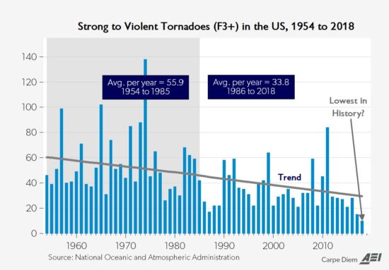
Also because climate change has cut the incidence of violent tornadoes in half.
Warming the highest latitudes the most has decreased the meridional temperature gradient and weakened weather systems that cause tornadoes.
https://inside.nssl.noaa.gov/nsslnews/2009/03/us-annual-tornado-death-tolls-1875-present/
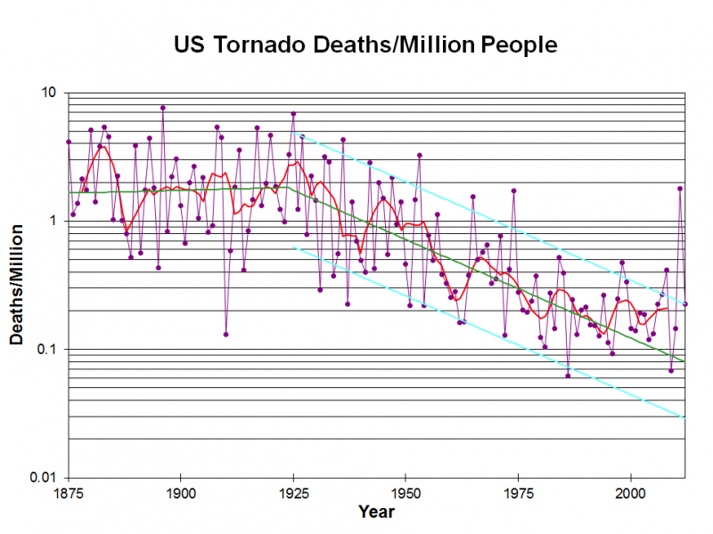
The deadliest tornado in US history tracked within 50 miles of Evansville back on March 18, 1925!
Kids were still in school that day when the tornado first formed.
Nobody in the path realized what was coming........UNTIL THEY ACTUALLY SAW IT!
++++++++++++++++++++++++++++++++++++++++++++
Wonderful description of this event:
https://en.wikipedia.org/wiki/Tri-State_tornado_outbreak
I was chief meteorologist at WEHT from 1982-93 and did a special story, covering this tornado in 1990(65 year anniversary).
https://www.youtube.com/watch?v=-w7_CLn8QSs
I interviewed a number of people in Griffin IN, who were in their 70's/80's then that had witnessed the event. Never forget what one lady said:
Paraphrased: "After the tornado hit, there were hundreds of people running all over the place aimlessly and in shock. We thought several were black people but they weren't. They were just covered in mud from the Wabash River"
The Wabash River is a couple of miles to the west of Griffin!
++++++++++++++++++++++++++++++++

The Severe Storm forecast Center has moved the enhanced risk from their day 2 to day 1 outlook........as expected.
This will still be a late Friday afternoon/evening to overnight event.
Here are some good forecast philosophy discussions that were updated this morning...... to help you understand the weather dynamics. These are all NWS locations that that have area's of responsibility within the enhanced risk zone today.
Some are technical in nature but that's what you expect from the experts analyzing all the factors coming into play:
From Paducah(good one):
From Nashville:
From Memphis(good one):
From St. Louis(good one):
From Louisville(good one):
From the Severe Storm Center(the super experts):
https://www.spc.noaa.gov/products/outlook/day1otlk.html
Made an addition to the page on the Great TriState tornado.
As mentioned yesterday, the Storm Prediction Center updates their outlook maps as we get closer to severe weather events.
A short while ago, they upgraded the risk area to include a MODERATE, level 4 on a scale of 1-5 risk......almost up to but just southwest of Evansville.
They did this because of higher confidence, after seeing the latest data.......of the specific geographic location that has the highest threat with more, almost bullseye type accuracy on the graphic below. They really are amazing at their jobs!
This is fairly typical as we get very close to the event and it means a very serious threat for people living in or close to these areas.
https://www.spc.noaa.gov/products/outlook/
| Current Day 1 Outlook | |
| Current Day 2 Outlook |
This was their updated forecast philosophy(not much different than before)
What does the difference between enhanced and moderate risk mean?
As mentioned, the enhanced, level 3 risk carries a 10% chance of a tornado within 25 miles of any one location. At moderate, level 4 the risk is elevated to a 15% chance of a tornado within 25 miles of your location.
NOTE: These maps and all the radar images below are constantly updated.............so the severe weather will be long gone after Friday Night!
++++++++++++++++++++++++++++++++++++++++++++
Lots of action taking place now.

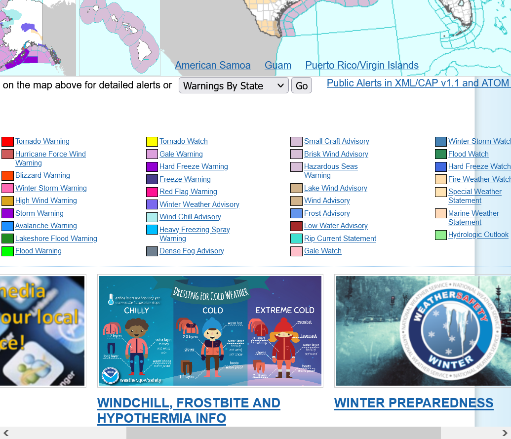
Hazards map below. Tornado watches in yellow. See the color code for other hazards below. Oranges inside the yellows are WARNINGS.

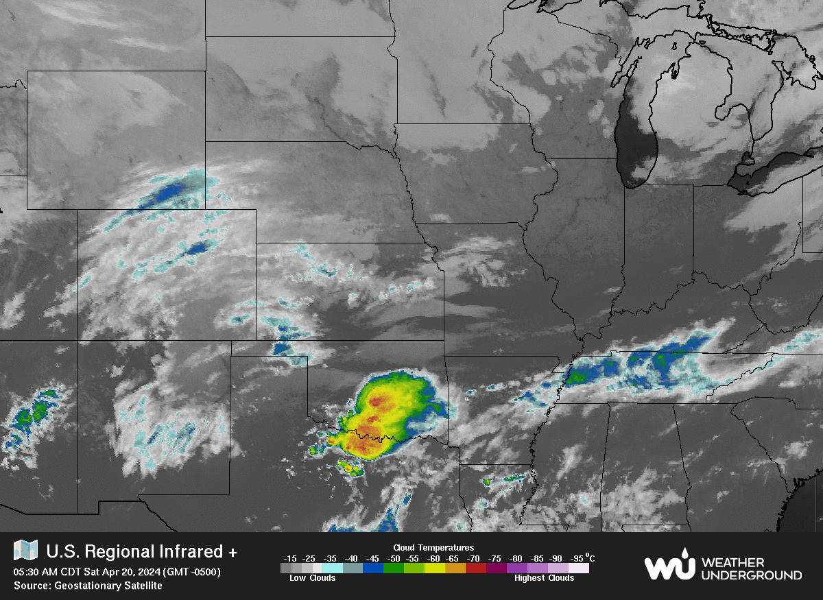
Here's the last surface pressure/isobar map and observations at all the stations below that.......updated every few minutes.
You can see the deepening surface low in MO right now and strong, counter clockwise winds around it.
https://www.spc.noaa.gov/exper/mesoanalysis/new/viewsector.php?sector=20


Always a good idea to have your electronics charged to 100% in case you lose power in a situation like this.

Long track, violent tornado that's been on the ground since forming in Arkansas, has tracked northeast into southwest KY, aiming at areas just south of Madisonville.
Dawson Springs about to be clobbered.........tornado emergency declared for that city because this very deadly tornado has been on the ground and has been tracked for over 2 hours.
The most severe weather has been hitting areas SOUTH of Evansville, where the moderate, level 4 risk was accurately assessed by the Storm Prediction Center earlier today.
More storms are farther west/northwest in MO to IL, associated with the cold front that will hit in the very early morning hours.
The radar pix above is being constantly updated.
A red box is a Tornado warning. Yellow box is a severe thunderstorm warning.
The tornado in sw. KY has been on the ground for well over 3 hours now, since it formed in c. AR earlier this evening. This is extremely rare and bad news.
Here's what the line of storms looks like along the cold front, farther northwest, in IL......man, they are racing and broken up in a line.
St. Louis is on the bottom left of the first radar image and in the center of the 2nd one.


Heres a look, farther east from the Louisville radar. The 4 hour long, long track tornado that started in n.Arkansas is aimed for just south of Louisville.......if it holds together for another hour+.
So far, its been hitting mostly rural areas, which are getting obliterated. This would be a much more densely populated area.
Red boxes are TORNADO warnings. Yellow boxes are severe thunderstorm warnings.

I just found this cool loop. You can see the well defined cold front as it lifts the air ahead of it, resulting in the very humid air in the lower levels, rapidly rising, cooling and moisture condensing out, along with extreme turbulence.
WEHT says that the NWS is saying the thunderstorms are moving at 80 mph!
Holy Cow, that's the fastest I've ever seen in my life!
http://www.evansvilleweather.net/
(scroll down-or up for more)
Here in southwestern Indiana, we're extremely grateful to have completely dodged the severe weather bullet on Friday/yesterday!
There were 2 areas of widespread/organized severe weather on Friday. The one to the north was associated with the cold front.
The area to the south was associated with some extreme wind field dynamics and instability that resulted in a super cell with an extraordinarily rare, very long track, powerful/deadly tornado that formed in northeast AR and stayed on the ground for almost 4 hours as it tracked across southwest KY. There was an upper level perturbation and cooling aloft associated with that violent tornado.
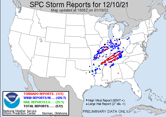
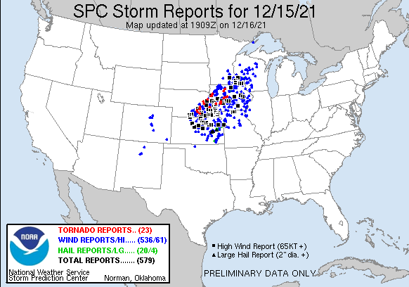
High wind reports =231
Tornado reports(some deadly) =37
Severe weather for Southwest Indiana = ZERO
https://www.spc.noaa.gov/climo/reports/211210_rpts.html
This was one of the later statements about that tornadic super cell from the Storm Prediction Center as it tracked southeast of Evansville at 10:44 pm on Friday.
https://www.spc.noaa.gov/products/md/md2003.html

https://abcnews.go.com/US/wireStory/dead-injured-tornado-hits-arkansas-nursing-home-81687228
Kentucky Gov. Andy Beshear says he fears tornadoes have killed 70 people in the state and the death toll may exceed 100
https://www.reuters.com/world/us/fifty-people-likely-killed-tornadoes-kentucky-governor-2021-12-11/
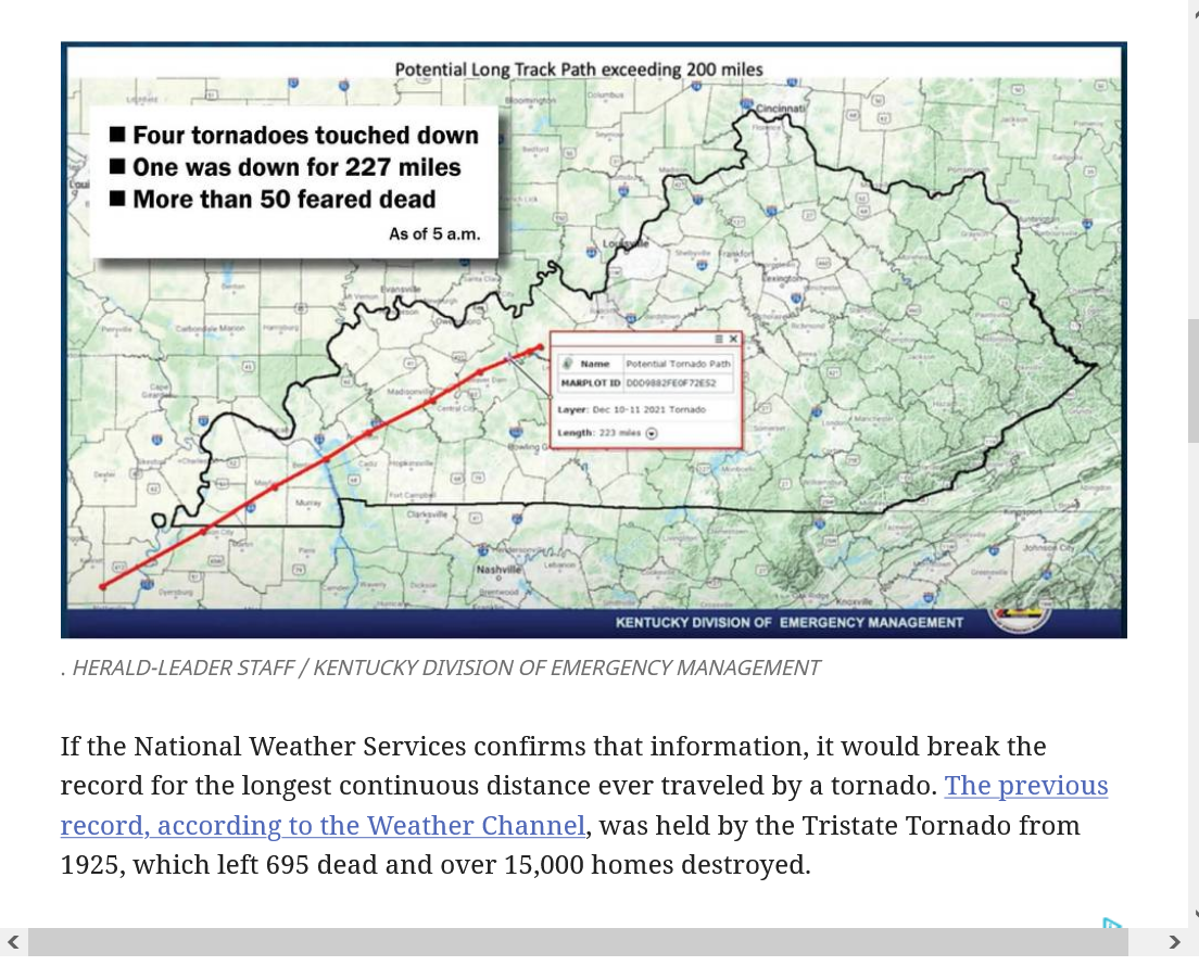
WASHINGTON, Dec 11 (Reuters) - A devastating swarm of tornadoes ripped through six U.S. states, killing more than 70 people in Kentucky and leaving a trail of destroyed homes and businesses along a path that stretched more than 200 miles, officials said on Saturday.
At least four tornadoes touched down overnight in parts of Kentucky, causing significant damage in more than a dozen counties. The primary tornado travelled more than 227 miles (365 km) across the state, Kentucky Governor Andy Beshear said.
This is horrific and profoundly moving:
Drone video shows an aerial view of tornado damage in Bowling Green, Kentucky
1.com/video/weather/kentucky-tornado-damage-drone-video/417-b81dcfa7-d1ff-4943-97ac-829117d21059
The National Weather Service will confirm if a single tornado tracked over 200 miles from Arkansas to Kentucky, which could set the record for longest tornado in U.S. history
"The National Weather Service will perform the official tornado survey to confirm if it was a continuous tornado or several tornadoes produced by the same storm. If confirmed as one single and continuous tornado, it will set the record for the longest “long-track” tornado in U.S. History.
The longest on record is the “Tri-State” tornado from 1925, which tracked 219 miles across Missouri, Illinois and Indiana.
While the National Weather Service provides the official intensities of the tornadoes after conducting storm surveys, there are several indications that the tornadoes, including the Mayfield one, were in the strong to violent categories, which meteorologists consider EF3, EF4 or EF5 on the Enhanced Fujita Scale.
One such indicator was debris lofted high into the air. Radar suggested that the Mayfield tornado threw debris over 30,000 feet into the air. That's the altitude commercial airplanes fly."
https://www.marketforum.com/forum/topic/78838/#78851
"And climate change may also have played a role."
++++++++++++++++++++++++++++++
metmike: This is outrageous and pathetic to use a horrific tragedy to completely mislead people about climate change.
Climate change has irrefutably REDUCED the number of violent tornadoes like this by around 40% by warming the highest latitudes the most. This reduces the meridional temperature gradient and weakens jet streams and cold fronts that cause the most violent tornadoes.
https://www.marketforum.com/forum/topic/31370/#31626
metmike: More climate change MISinformation.
The main reason for the increase in twisters compared to the pre warming world is because we have sensitive Doppler radars that can detect dozens of weak tornadoes that went undetected and unreported previously during outbreaks!!!!
Violent tornadoes like this one are DOWN 40%, not in spite of climate change but BECAUSE OF climate change.....see the actual data in the post above......and here below where the author is partly confused in stating that it weakens tornadoes(not appreciating that DOPPLERS have increased the detection of the WEAK tornadoes with more people in areas to report seeing one ).
Violent tornadoes were always detected/reported.........doppler radar or no doppler radar.
http://berkeleyearth.org/static/pdf/berkeley-earth-truth-about-tornadoes.pdf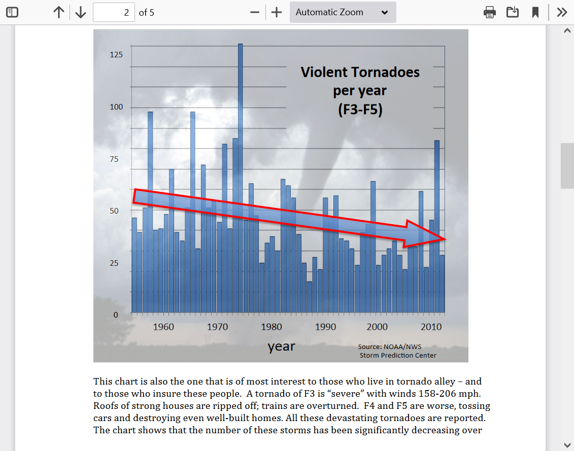
The data clearly shows this but one would already expect it based on meteorology 101 and atmospheric physics!
Climate DISinformation from sources that people and journalists go to and THEY repeat the DISinformation.....making everybody dumber.
In case you're new here, I've been a practicing environmentalist for 4 decades and recognize that humans are responsible for at least half of the global warming but neither political party has a franchise on the truth.
![]()
May 30, 2019
"We asked some of the leading scientists who have been studying tornadoes and the physics of extreme weather and climate change to share their insights.
Many of them pointed out that it can be tough to detect tornado trends because comprehensive records only go back a few decades and there’s a lot of variability in tornado activity year to year. But they said some shifts are starting to show: while tornado intensity doesn’t appear to have changed, there are more days with multiple tornadoes now, and there may be a shift in which regions are especially prone to tornadoes.
"There is growing evidence that “a warming atmosphere, with more moisture and turbulent energy, favors increasingly large outbreaks of tornadoes, like the outbreak we’ve witnessed in the last few days,” said Penn State University climate researcher Michael Mann."
metmike: Michael Mann is the most corrupt/dishonest climate scientist in human history and I can't emphasize any stronger how the paragraph above that is just blatantly wrong based on all the authentic data that I showed on the previous pages (as an independent, objective atmospheric scientist) as well as atmospheric physics and meteorology 101.
But I totally get why people have all these completely wrong ideas about weather and climate change. Even very bright people that read this article would believe it. Only a person with all the actual data would know its DISinformation.
One can say though, that the 1 deg. C of global warming has increased the chance for violent tornadoes in December by a single digit %..........while greatly reducing the occurrence during the peak months(by 50% in many cases)......and cutting down the overall occurance by 42% based on the data over the past 60 years.
However, December will NEVER have an increase to the risk similar to a month like April. NEVER.
Why is that?
Because alot of the heat energy that contributes to the instability comes from the sun.
The sun's low/weak angle in December will NEVER be strong enough to generate the heat and instability that comes with it .........that the much higher angled sun of March/April/May has.
Not even close.
Yesterday's storm had unique characteristics/dynamics that were rare and INDEPENDENT of diurnal heating from the sun(and NOT from climate change).
This is why it existed at a temperature just below 70 degrees in the unstable sector.
Another thing that makes it completely absurd to blame this on global warming:
https://www.marketforum.com/forum/topic/78694/
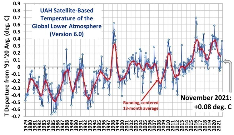
The current La Nina is a global COOLING pattern and the latest global temperature is just +.08 deg. C above the 30 year average.
Global cooling and La Nina's like this are what INCREASES violent tornadoes.
El Nino's and the associated global warming DECREASE violent tornadoes.
https://indiana.pbslearningmedia.org/resource/nvdt.sci.earth.lanina-1/la-nina-and-tornado-outbreaks/
"In this video excerpt from NOVA: “Deadliest Tornadoes,” examine how the climate phenomenon of La Niña may help set up conditions conducive to large tornado outbreaks. Thermal images show a region of unusually cold sea-surface temperatures in the eastern Pacific Ocean, off the coast of Peru. This deviation from normal sea-surface temperatures, called La Niña, impacts ocean processes and global weather."
metmike: Global warming CAN'T cause unusually cool temperature anomalies in the eastern/central tropical Pacific!
In fact, it's the complete opposite! The current La Nina and natural (temporary) global cooling we're experiencing increased the chance for this outbreak.
The La Nina and slight/temporary global cooling is also responsible for the current drought in the West NOT global warming or climate change.
https://www.marketforum.com/forum/topic/73659/#73721
metmike: You can bet that, because of this horrific event, that people in this area will be ultra sensitive to forecasts that have the risk of severe weather in them.........during the next severe weather season.
https://www.kentucky.com/news/state/kentucky/article256512121.html
"According to the Kentucky Division of Emergency Management, the tornado originated in northeastern Arkansas and lifted up in Breckinridge County, covering a continuous distance of 223 miles. Gov. Andy Beshear reported the tornado may have traveled 227 miles."
metmike: The oddest thing is that I had a page/post about that previous record breaking tornado here, the evening before this one formed!
https://www.marketforum.com/forum/topic/78838/#78851
I was overcome with emotion the first time I watched the first drone video below:
Deb and I watched all of it unfold with the gifted local meteorologist Wayne Hart on WEHT and his doppler radar.
I would run back to my office numerous times and would update with links and radar images and discussions/projections and data at this thread.
Wayne was using something that he'd not used much before......because this was so extraordinarily rare.
A mode that showed the tornado debri field.
It was basically the radar showing peoples obliterated property, trees and all sorts of debri that was being lifted miles into the air from the ground.....completely separate from the wind or rain field.
It remained a very distinct patch on the screen for hours and tracked northeast, exactly identifying where the tornado was tearing up everything on the ground and lofting it thousands of feet into the air. It's the image in the bottom right box below.
https://en.wikipedia.org/wiki/Tornado_debris_signature

Comparison of four radar products: reflectivity, Z, top left; velocity, SRM, top right; and polarimetric products, differential reflectivity, ZDR, on bottom left; correlation coefficient, CC, on bottom right, used to identify TDSs
"Debris balls can be a result of anthropogenic or biomass debris and are more likely to occur if a tornado crosses a "target-rich" environment such as a forest or populated area. A TDS is most likely to be observed when a tornado is closer to a radar site and the farther away from the radar that a TDS is observed the more likely that the tornado is stronger. As a result of the strong winds required to damage structures and loft debris into the air, debris balls are normally the result of EF3 or stronger tornadoes on the Enhanced Fujita Scale. "
metmike: It was just colors on the tv or computer screen on Friday Night..........but you knew what it meant to people living there. You just knew from watching the radar and understanding it what was happening.
Then, when the sun came up and the drone shot video of the debri on the ground and this was passed on via the internet..........wow. It's almost overwhelming to just think about what we witnessed happening to all those people right in front of us.
Here it is again:
Kentucky Tornadoes, Climate Change, And Pressure Systems
https://wattsupwiththat.com/2021/12/13/kentucky-tornadoes-climate-change-and-pressure-systems/

https://nypost.com/2021/12/12/dont-buy-the-psuedo-scientific-hype-about-tornadoes-climate-change/
Experts say tornadoes with such intensity are rare later in the year during colder seasonal weather
https://www.theguardian.com/us-news/2021/dec/12/kentucky-tornadoes-biden-epa-climate-crisis-role
metmike: What in the heck is the matter with these people. We KNOW with absolute, 100% certainty that violent tornadoes like this have gone down during the last 60 year BECAUSE of the warming of the higher latitudes, weaker temperature gradients and weaker jet streams........irrefutable......indisputable and totally expected, based on the physics and meteorology. With all the observations/empical data clearly confirming it. Sources saying otherwise are either lying or ignorant/misinformed about the authentic science.
Why does politics always have to mess up everything for agenda's??
https://www.marketforum.com/forum/topic/78838/#78911
Severe weather this time around is 800 miles northwest in the Upper Midwest.
No threats in the area that get clobbered last week!
https://www.spc.noaa.gov/products/outlook/
| Current Day 1 Outlook | |
| Current Day 2 Outlook | |
| Current Day 3 Outlook | |
| Current Day 4-8 Outlook |
Latest weather here:
We continue to have an outpouring of our compassion/thoughts and prayers for the tornado victims just 60 miles south of us less than a week ago and it helps us to appreciate how fragile but awesome life is and to be grateful for the wonderful blessings that we have today......living in this current age of human history!
Reasonstobethankful here in 2021............and all the years to follow!
https://www.marketforum.com/forum/topic/45623/
One of the best things about living right now is the fact that we have powerful technology to inform people about events like this.........that didn't exist until this age.
Lives lost because of extreme weather are down 95% compared to 100 years ago.
People can go to a safe place 30 minutes before a violent tornado hits today. In 1925, they learned about that tornado.........when it was hitting.
People in the US can evacuate to areas away from a hurricane strike, saving the lives of almost everybody in the hurricane zones.

Another severe weather outbreak in the Upper Midwest yesterday.
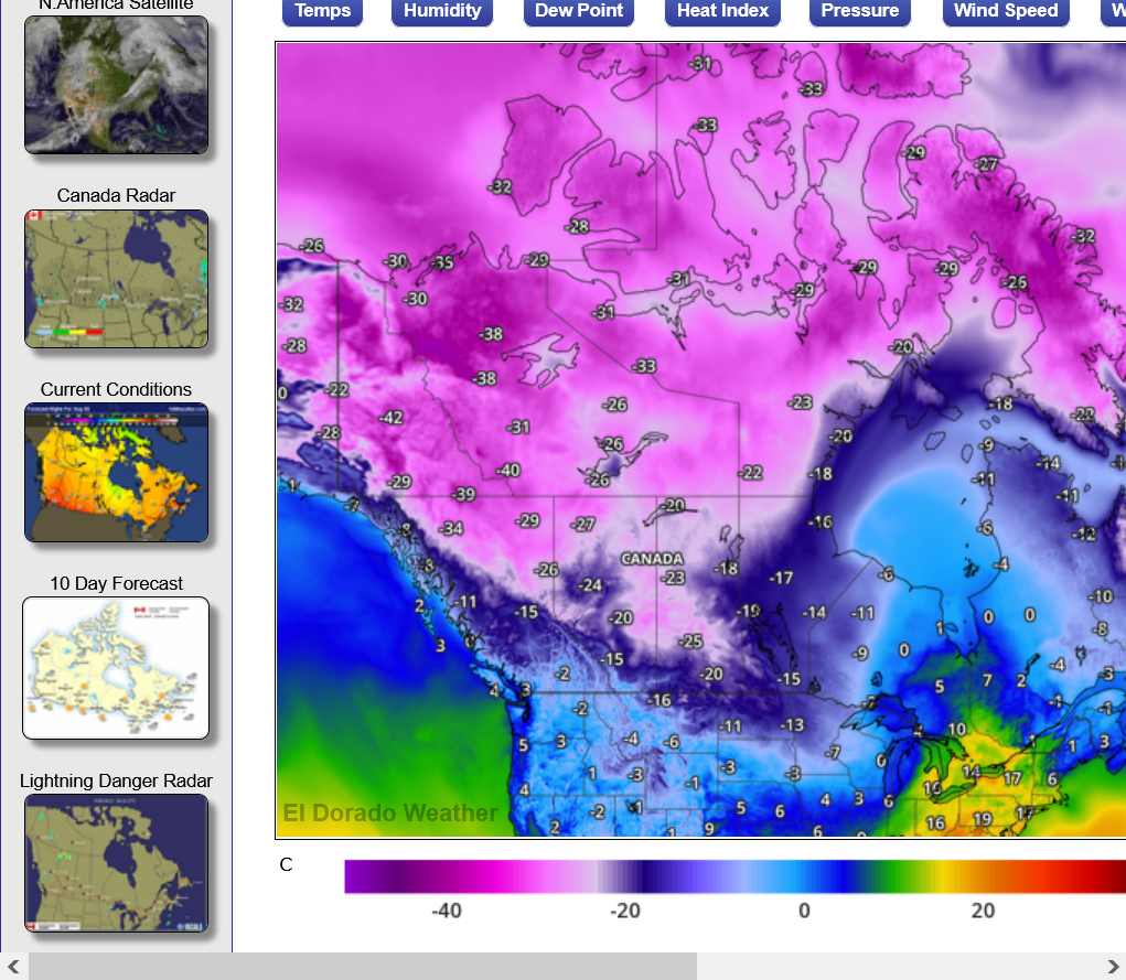
The biggest reason for these 2 severe weather outbreaks is the extreme cold in Canada right now.
Violent tornadoes are ALWAYS caused by approaching strong cold fronts and powerful jet streams.
Powerful jet streams are ALWAYS caused by extreme cold just north of much warmer air.
Powerful jet streams are what cause thunderstorms to become severe AND ROTATE.
Take away that extreme cold in Canada...........and almost none of this would have happened.
https://www.eldoradoweather.com/canada/current-conditions/temperatures.html
https://www.spc.noaa.gov/climo/reports/yesterday.html
This is a great comprehensive review!
https://wattsupwiththat.com/2021/12/17/on-tornados-and-extreme-weather-biden-is-wrong-again/
https://wattsupwiththat.com/2021/12/16/were-the-recent-tornadoes-the-result-of-global-warming/
