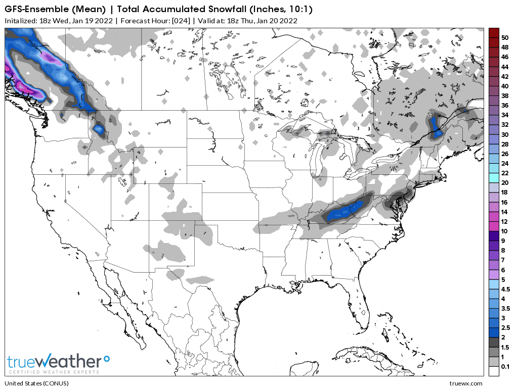
Here's the just updated snow forecast for the new weather system on Wednesday:
Amounts have dropped substantially in western KY from the previous few model runs. This one is the 0z GFS Ensemble mean.
Earlier on Tuesday, this model had up to 4 inches in W.KY. Now it's more like a max of 1.5 inches. If you live in southwest Indiana, this model below shows just a tad less than 1 inch of snow:
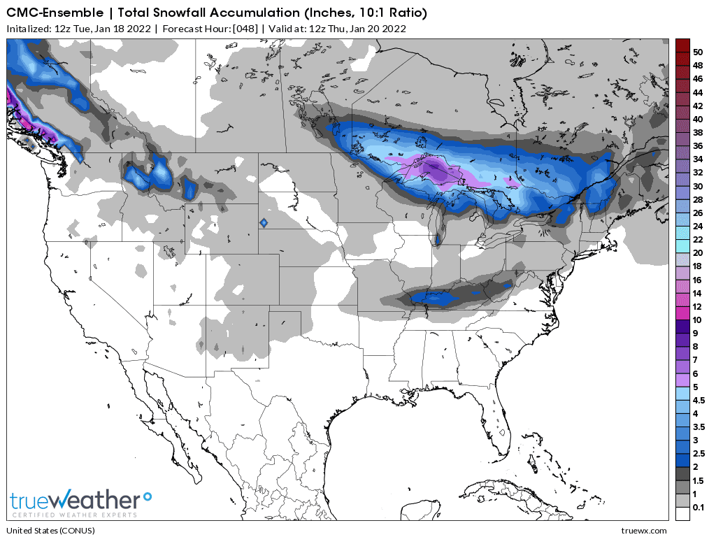
The 0z CMC ensemble model below has MORE snow than the GFS above
It has 2 inches for Evansville!
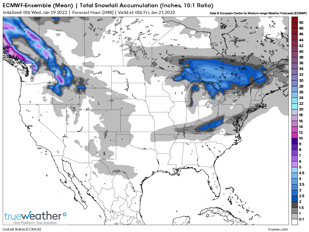
European model is the last one to come out below. It has about the same snow as the GFS model. A tad under an inch in Evansville.
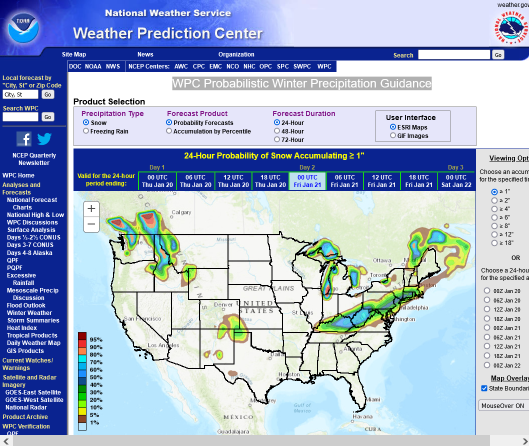
Here's the forecast from the snow experts!
WPC Probabilistic Winter Precipitation Guidance
https://www.wpc.ncep.noaa.gov/wwd/winter_wx.shtml
Not a very high chance of snow greater than 1 inch in Evansville:
Tracking the weather system. The next 3 maps update several times/hour:
Surface Pressure/Wind
https://www.spc.noaa.gov/exper/mesoanalysis/new/viewsector.php?sector=20

Temp/DP/Wind-Surface observations
https://www.spc.noaa.gov/exper/mesoanalysis/new/viewsector.php?sector=20#

Temp/Wind/DP/pressure below
https://www.spc.noaa.gov/exper/mesoanalysis/new/viewsector.php?sector=20#

Latest National radar images
https://www.wunderground.com/maps/radar/current

This link below provides some great data. Hit the center of the box below for the area that you want, then go to observation on the far left, then surface observations to get constantly updated surface observations.
 |
Local NWS for Evansville Indiana:
Hourly weather graph starting 1am Wednesday.

10am Wednesday:
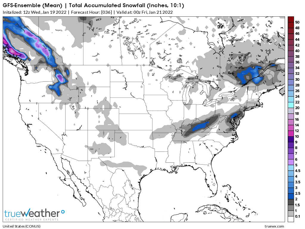
Latest 12z GFS ensemble JUST out.
Under an inch of snow in southwest Indiana.
Models don't matter much when we get this close. We use observations the most in what's called NOWcasting!
WOW! Look at the temperature gradient below!
When this cold front comes thru late this afternoon, temperatures are going to plunge 20+ degrees from the highs pretty fast! Maps below are constantly being updated.
It was 50 in Evansville IN an hour ago. It's below freezing in St. Louis right now and in the single digits in IA. That's the air headed southeast(and moderating a bit along the way).
Temp/Wind/DP/pressure below
https://www.spc.noaa.gov/exper/mesoanalysis/new/viewsector.php?sector=20#
Temp/DP/Wind-Surface observations
https://www.spc.noaa.gov/exper/mesoanalysis/new/viewsector.php?sector=20#
Latest National radar images
https://www.wunderground.com/maps/radar/current
Temp has dropped from 50 to 41. Should drop below freezing after 5pm.
6pm: The images on the radar below are updated, so this message applied to a radar image from before 3pm.........which has gone vamooos!
The bright shades on the radar below is SLEET!
Sleet has an extremely high reflectivity on radars.......almost looks like a thunderstorm. We are experiencing a narrow band of SLEET right now!
Snow amounts are going to be minor, however this sleet is going to cause a problem in some places.
Some potential for moisture on the roads to freeze in the evening before its completely evaporated......as temps plunge into the 20's.
Strong, gusty winds will cause the wind chill to drop well down into the single digits overnight.
Stiff N winds early on Thursday will keep the windchill in the single digits in the morning, even with sunshine.
Latest local radar at this link.
From earlier/prior to 3pm Wed: The image below is earlier and shows you what sleet looks like on a radar.......oranges and especially reds are high reflectivity areas but not because its heavy precip because it's sleet.

All after school activities were cancelled on Wednesday for the EVSC, including chess.
We are currently experiencing some light to moderate sleet that might pose some problems if it continues, even as temperatures are above freezing at the surface.
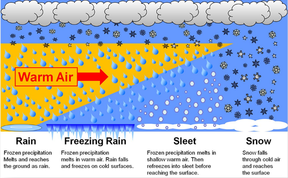
Temperatures just below the clouds are ABOVE freezing, so the precip is falling as snow that melts into rain when it hit the warm pocket up there.
However there is a shallow layer of below freezing air just below that........so the rain is freezing on the way down BEFORE it gets to the surface.........creating SLEET!
The sleet is just rain that freezes before it hits the ground.
This is not freezing rain which is rain that freezes AFTER it hits the ground. Surface temperatures are too warm for that. There is no threat for this.
The main threat for roads to ice up is around sunset when the surface temp drops below freezing.
However, this sleet will cause some unexpected problems if it continues.
And we are almost at that stage already before 3pm Central!!!
So assume that roads are starting to get icy NOW a couple of hours earlier than expected!
4pm update: temperature was 35 degrees in Evansville, so we have a couple of hours to go before surface temps drop cold enough to start freezing up moisture on the roads.
If not much more falls, the moisture there now will have a chance to mostly evaporate before it freezes.
The period of sleet only lasted 30 minutes or so and has been over during the past hour, so it didn't result in any major issues.
It's interesting to see what happens around houses/garages and buildings when it sleets. Sleet will not stick to the roof, so it all slides down and piles up, completely surrounding the entire building below where there is a sloped, shingled roof.
In the early 2003, 36 hour sleet event, there were sleet piles 4-6 feet high surrounding many buildings below the roofs.
Sleet piling up:
https://www.youtube.com/watch?v=xm6uulUkuCk
https://www.youtube.com/watch?v=b0NLZGaFm8c
Freezing Rain and Sleet
https://www.weather.gov/rnk/Measure_Icing
Latest models don't mean much when the snow event is this close and still looking even lighter for southwest IN.
Amounts likely to be well under an inch. This was the just out 18z GFS ensemble mean.
Looks like southwest Indiana will end up with just a few flurries this evening and the main Winter weather was a somewhat surprising 30-45 minute period of sleet that started around 2 pm when the temperature was still 37 degrees.
An unusual vertical temperature profile was going on.
I don't ever remember sleet when the temperature is that warm, 37 degrees.
It always happens with a layer of warmer air aloft that causes rain that falls into colder air below that results in frozen rain/ice pellets/sleet but that colder air below is almost always cold all the way to the surface.
What we had in this case was extremely unusual. Get this:
1. At the start of the precipitation's travels, just after 2pm, we had below freezing temps in the clouds, so it likely started as snow when the precipitation began its descent.
2. On the way down it hit a warm layer that completely melted the snow and turned it into rain.
3. Then that rain fell farther into a subfreezing layer that froze the rain, turning it into sleet/ice pellets.
4. The sleet finished its journey downwards, finally arriving at the surface, which featured ANOTHER very shallow warmer layer hugging the ground that was still above freezing at 37. Not deep enough to melt the sleet........very shallow so it remained as sleet.
The Weather Advisory has been cancelled for the Indiana counties of our area and extreme far northwest KY with the accumulating snow staying south of the Ohio River.
The current temperature of 23 degrees is already 27 degrees colder than the high earlier today, just before noon.


