Awesome educational discussion from one of the worlds best communicating meteorologists!
Comparing the two phases of the ENSO in the image below, we can see that they typically produce an entirely different winter weather pattern across North America, by changing the position of the jet stream.

La Nina (cold phase) features a stronger and extended polar jet stream from Alaska and western Canada into the United States. But the El Nino (warm phase) features a stronger subtropical jet stream and an amplified storm track over the southern United States.
++++++++++++++++++++++++++++++++++
metmike: As everybody knows by now, we're in a long lived La Nina (that has had a recent, surprise surge stronger) that will continue thru the upcoming growing season.
Potential harbinger of a hot/dry Summer.
La Nina/-PDO with latest Summer Forecast 4-26-22
25 responses | 1
Started by metmike - April 26, 2022, 6:59 p.m.
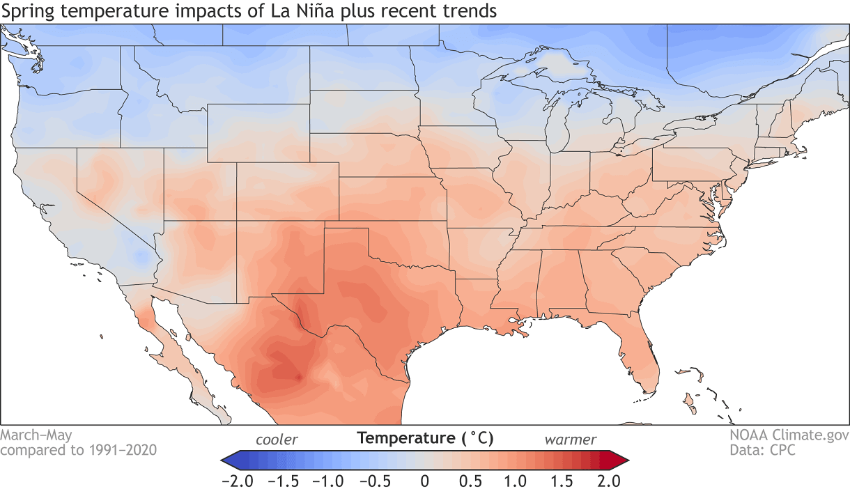
We are currently in a La Nina cycle. And below we have the average spring temperature impact of the La Nina. It promotes a stronger jet stream over the north/northwest, keeping the northern United States cooler and the south warmer than normal.
Compare that La Nina analog for May above with the latest forecast and see how similar they are!
Cold NORTH and hot SOUTH.
What happens in June with many La Nina's is that the jet stream retreats north and the hot SOUTH marches NORTH.
https://www.marketforum.com/forum/topic/83844/#83852
Extended weather.
https://www.cpc.ncep.noaa.gov/products/predictions/610day/ | |||||||||
| 6 to 10 day outlooks | |||||||||
| Click below for information about how to read 6-10 day outlook maps Temperature Precipitation | |||||||||
| Click below for archives of past outlooks (data & graphics), historical analogs to todays forecast, and other formats of the 6-10 day outlooks ArchivesAnalogsLines-Only FormatGIS Data | |||||||||
Temperature Probability | |||||||||
| Precipitation Probability | |||||||||
| |||||||||

