Hurricane Nicole: forecasted to landfall on FL late tonight
18 responses | 0 likes
Started by WxFollower - Nov. 2, 2022, 11:28 p.m.

 The models are pretty much unanimous on a complex storm system forming this weekend in the NE Caribbean or the SW Atlantic, which could then move NW to the SE US next week per model consensus. Subtropical and/or tropical cyclone development is very possible, if not likely. Thus, this could conceivably have a significant effect on SE US weather, especially near the Atlantic coast and most likely in FL, on Election Day.

 The 18Z GEFS is still another run that suggests significant effects (rain and wind) quite possible over E FL on US Election Day, something that could reduce turnout there. Reduction % in turnout due to wx tends to not be equal for all sides. Thus it could have a significant effect on the outcome of close races.

 I looked back every two years to see if there were any previous US Election Days marred by an Atlantic basin tropical or subtropical cyclone. I found none affecting the lower 48 states even though I did find 1984's TS Klaus that directly affected PR on Election Day (11/6). So, this system could make history in the lower 48 as very likely the first Atlantic TC or STC affecting a portion on Election Day.

 8PM Atlantic NHC TWO:

Southwestern Atlantic:
A complex, non-tropical area of low pressure is expected to develop 
this weekend over the northeastern Caribbean Sea or the 
southwestern Atlantic. Some slow subtropical or tropical 
development of this system is possible afterward while it moves 
generally northward to northwestward through early next week.
* Formation chance through 48 hours...low...near 0 percent.
* Formation chance through 5 days...low...20 percent.

Forecaster Brown


Comments
By MarkB - Nov. 3, 2022, 12:01 a.m.
Like Reply

No matter what, I will be there. aRRRR!


By WxFollower - Nov. 3, 2022, 12:34 a.m.
Like Reply

Mark said:

"No matter what, I will be there. aRRRR!"

------------

Mark, I don't follow you. Or to rephrase it as Mel Brooks might ask, what in the wide, wide, wide world of sports are you talking about lmao? Or as Jed Clampett might ask, what in tarnation!?


By metmike - Nov. 3, 2022, 1:54 a.m.
Like Reply

Thanks Larry!

I hadn't looked at the tropics for weeks but am on it now, thanks to you!

Surface Weather maps for days 3-7 below:

https://www.wpc.ncep.noaa.gov/medr/medr.shtml

https://www.wpc.ncep.noaa.gov/medr/5dayfcst_wbg_conus.gif

++++++++++++++

https://www.marketforum.com/forum/topic/83844/#83848

https://www.marketforum.com/forum/topic/83844/#83849

https://www.marketforum.com/forum/topic/83844/#83850


By cutworm - Nov. 3, 2022, 9:31 a.m.
Like Reply

thanks wx

By metmike - Nov. 3, 2022, 11:17 a.m.
Like Reply

https://www.nhc.noaa.gov/


tabCentral PacifictabEastern PacifictabtabAtlantictab
              
tab


Lisa's history.

[Image of cumulative wind history]

By WxFollower - Nov. 4, 2022, 5:59 p.m.
Like Reply

 Model consensus is forecasting 500 mb heights that are as high as 2.5 SD above the mean for early November in the NE US Wednesday night. That is equivalent to saying 500 mb hts that are at the 99% percentile meaning hts that high or higher in early November there happen only 1% of the time.

 With that strong of a high to the north, the SW Atlantic/Bahamas/SE US is in a highly unusual pattern for early November as regards tropical potential. With only 8 TCs having formed since 1851 in the SW Atlantic Nov 1-10 (see link below) and considering this highly anomalous pattern, there's not much historical track data/climo to utilize to predict what will happen. So even though none of those 8 SW Atlantic originating TCs hit the US, that doesn't mean much in this very unusual pattern:

https://www.nhc.noaa.gov/climo/images/nov_1_10.png

 If we incorporate the current SW Atlantic SSTs, we get even further from normal early Nov tropical potential. They're currently 28 to 29 C (82-84 F), which is ~1C/2F warmer than the normal and near the normal for mid October (normal found here):

https://www.nhc.noaa.gov/gifs/SST/AL_10_OCT_1971-2000_RSST.gif

 Along with this very strong H5 ridge to the north and warm SSTAs, 200 mb wind speeds are forecasted to plunge well below normal early to mid next week in the SW Atlantic. So, shear may become unusually light then.

 Considering all of the above, the NHC has quite a challenge and will make forecasting discussions quite interesting.

By metmike - Nov. 4, 2022, 6:24 p.m.
Like Reply

Wonderful report Larry!

By WxFollower - Nov. 6, 2022, 2:55 a.m.
Like Reply

Thanks, Mike.

 
1. The last few runs of models all have a tropical cyclone. So, I don't think we're looking at just the subtropical cyclone option any more.

2. Now that we're closer, it appears that the wx on Election Day will not be that bad in the SE US (other than coastal/marine).

3. However, the models are now all progging a TS or hurricane vs many not doing that before. Any direct impact to the SE US from this wouldn't start before Wednesday afternoon or Wednesday night. IF there later really is a hurricane that is progged to start directly impacting FL (SE or further north depending on what track it takes) Wednesday PM and keeping in mind the panic and prep that always occurs 1-2 days before in addition to evacuations, what do folks here think will happen as regards Election Day, which has its own chaos? Wednesday would already be too late for the most part with it starting to come in late that day. Does anyone think it will have to be postponed in Florida? Keep in mind that this situation would be totally unprecedented. I've yet to see anyone say anything about this.

 Earlier when I was thinking about Election Day, I was thinking only about reduced turnout possibilities due to inclement wx on that day. Now it is potentially a much bigger deal than that.

 Keep these in mind:

 "A watch is issued when hurricane conditions are a possibility within 48 hours. A warning is issued when a hurricane is expected in an area within 36 hours."

 Based on the possibility of hurricane conditions in parts of FL on Wednesday night, there could easily be not just a H watch but even a H warning already issued on Election Day for part of FL! A watch could be issued Monday night. The implications of this possibility as regards the upcoming election in FL are totally unpredictable when considering preparations as well as the typical chaos several days in advance of a hurricane.


By metmike - Nov. 6, 2022, 12:27 p.m.
Like Reply

Thanks Larry!

SST's are a tad above average at the far southeast tip of FL (just below average Southeast US coastline and Gulf Coast) and still warm enough for a hurricane.

https://www.nhc.noaa.gov/tafb/atl_anom.gif

By metmike - Nov. 6, 2022, 12:34 p.m.
Like Reply

Rare November hurricanes that have impacted Florida in the past

https://www.baynews9.com/fl/tampa/weather/2021/11/19/the-rare-november-florida-hurricanes

The Sunshine State has seen a total of eight named storms make landfall during the month of November, two being hurricanes.

While the most recent was Tropical Storm Mitch, which made landfall near Naples in 1998, the first recorded strike was back in 1935 from a hurricane called "Yankee" due to its very late arrival and unusual movement to the southwest.


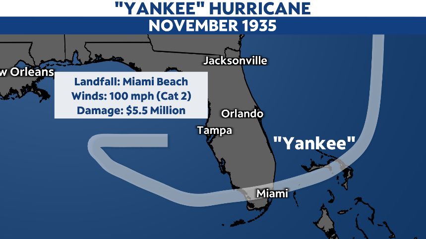
Extensive damage was reported in South Florida, with portions of Miami Beach severely flooded. Being more rural at the time, the area suffered 5.5 million dollars in damages. Five deaths were also reported from the storm.

The second and much more memorable November hurricane to strike the state was Hurricane Kate back in 1985.

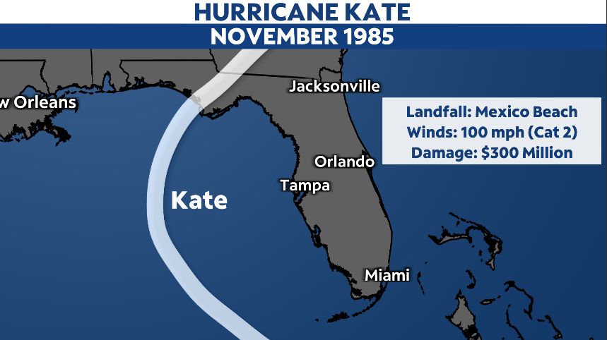
Kate developed north of the Lesser Antilles, then slid south of Florida, grazing northern Cuba. The storm then lifted northward into the Gulf of Mexico.

At one time, Kate was a Category 3 major hurricane with winds of 120 mph.

The storm luckily did weaken as it approached the Florida panhandle, but still roared ashore as a Category 2 storm with winds of 100 mph. Kate made landfall near Mexico Beach on November 21.

Damage from Kate was also extensive. The hurricane produced significant storm surge along the northern Gulf coast with power line damage leaving 90 percent of Tallahassee without power.

Kate racked up to 300 million dollars in damages in Florida.

By WxFollower - Nov. 6, 2022, 2:35 p.m.
Like Reply

Thanks, Mike. Note that none of these 8 were anywhere close to Election Day except for Mitch of 1998, which hit FL 36 hours later as a TS. And there are no hurricanes that hit the US anywhere close to Election Day.

By WxFollower - Nov. 7, 2022, 11:08 a.m.
Like Reply

 This is forecasted to bring a portion of the east coast of Florida hurricane conditions Wednesday night. Considering that part of FL is already under a hurricane watch and that preparations are needed and thus are already starting, how will this affect the election in Florida tomorrow? This is a mess.

By metmike - Nov. 7, 2022, 11:23 a.m.
Like Reply
By WxFollower - Nov. 8, 2022, 12:27 p.m.
Like Reply

Thanks, Mike. Nicole is now a TS and is still expected to hit FL as a hurricane Wednesday night/Thursday morning.

By metmike - Nov. 8, 2022, 12:30 p.m.
Like Reply

See the latest updates above. The forecast model tracks have  a great deal of spread currently. 


These maps are updated every few minutes. When Nicole get's closer to FL, we'll get a zoomed in version for you.

https://www.spc.noaa.gov/exper/mesoanalysis/new/viewsector.php?sector=19

https://www.spc.noaa.gov/exper/mesoanalysis/new/viewsector.php?sector=18


https://www.spc.noaa.gov/exper/mesoanalysis/new/viewsector.php?sector=18#


https://www.weather.gov/mlb/


Local MLB Radar

By metmike - Nov. 8, 2022, 12:41 p.m.
Like Reply

7 Day Total precipitation below:

http://www.wpc.ncep.noaa.govcdx /qpf/p168i.gif?1530796126

http://www.wpc.ncep.noaa.gov/qpf/p168i.gif?1530796126


By WxFollower - Nov. 9, 2022, 6:15 p.m.
Like Reply

Thanks, Mike. Nicole has just been upgraded to a hurricane with 75 mph winds. Still headed to FL landfall late tonight.

By metmike - Nov. 10, 2022, 12:44 a.m.
Like Reply

Biggest thanks to you Larry, for alerting us about this hurricane an entire week ago. I wasn't even looking then and wouldn't have noticed for at least a couple of days after that.

https://www.marketforum.com/forum/topic/90245/


Please scroll up for the latest or go here:

https://www.marketforum.com/forum/topic/90245/#90380

https://www.marketforum.com/forum/topic/90245/#90415