Strong tornadoes possible 11-29-22
13 responses | 1 like
Started by metmike - Nov. 29, 2022, 8:38 a.m.

The Severe Storms Forecast Center has an elevated risk for tornadoes today in parts of the south.


Severe Storm Risk......updated  daily(days 1 and 2 twice daily).

https://www.spc.noaa.gov/products/outlook/

Current Day 1 Outlook
        1300 UTC Day 1 Outlook             
         
          Current Day 2 Outlook
          0600 UTC Day 2 Outlook               
      
          Current Day 3 Outlook
          0600 UTC Day 3 Outlook               
     
          Current Day 4-8 Outlook
          Day 4-8 Convective Outlook
Comments
By metmike - Nov. 29, 2022, 8:41 a.m.
Like Reply

Let's focus our attention on this area today/tonight.

You can get the Severe Storm Centers latest outlooks at the link below.


https://www.spc.noaa.gov/products/outlook/day1otlk.html


Tornado risk below


Wind threat below


Hail threat below


Valid 291300Z - 301200Z    ...THERE IS A MODERATE RISK OF SEVERE THUNDERSTORMS FROM   NORTHEASTERN LOUISIANA ACROSS CENTRAL MISSISSIPPI...    ...SUMMARY...   Tornadoes, very large hail, and severe wind gusts are expected this   afternoon into the overnight period across parts of the lower to mid   Mississippi Valley, Mid-South and parts of the Southeast.  A few   strong tornadoes will be possible.
By metmike - Nov. 29, 2022, 8:42 a.m.
Like Reply

Current Hazards at the link below.

Note that we have snow going on in the Upper Midwest, which has been the main feature on this map. Late this afternoon, the South will get most of the attention.

Go to the link below, hit hazards box in the top right hand corner(it will also define all the color codes), if its not already in the hazards mode when you load the link.

 Then you can hit any spot on the map, including where you live and it will go to that NWS with all the comprehensive local weather information for that/your county. 

https://www.weather.gov/                                                                                                                 


Latest National radar images


https://www.wunderground.com/maps/radar/current


Static mapCA - BakersfieldNY - BinghamtonND - BismarckNH - BerlinTX - BrownsvilleKY - Bowling GreenMI - CadillacNC - CharlotteGA - ColumbusOH - DaytonCO - DenverIA - Des MoinesFL - Key WestVA - RoanokeCT - HartfordMO - Jefferson CityOK - LawtonNE - North PlatteAR - Little RockMT - LewistownLA - New OrleansID - McCallFL - Saint PetersburgSD - PierreAZ - PrescottUT - ProvoOR - RedmondWY - RivertonNV - RenoNM - RoswellTX - San AntonioVA - StauntonKS - SalinaIL - SpringfieldMN - Saint CloudWA - TacomaMS - Vicksburg


            This link below provides some great data. After going to the link, hit "Mesoanalysis" then,  the center of any box for the area that you want, then go to observation on the far left, then surface observations to get constantly updated surface observations or hit another of the dozens of choices.

https://www.spc.noaa.gov/


 Northwest Southwest Central Plains Northern Plains Southern Plains Midwest East Central Northeast Southeast 
Found a great new link/site that shows us how much precip fell(from 1 hr to 72 hours) for different periods to share with you.
https://www.iweathernet.com/total-rainfall-map-24-hours-to-72-hours
Data Update Cycle: The 1-hr mosaic is updated every 5 min (approx). All other mosaics are now updated hourly, including the 48h and 72h maps.
The site does not allow me to copy the actual images/data here, as we do with all the other links above..........so just go to the link!
By metmike - Nov. 29, 2022, 8:48 a.m.
Like Reply
By metmike - Nov. 29, 2022, 8:51 a.m.
Like Reply

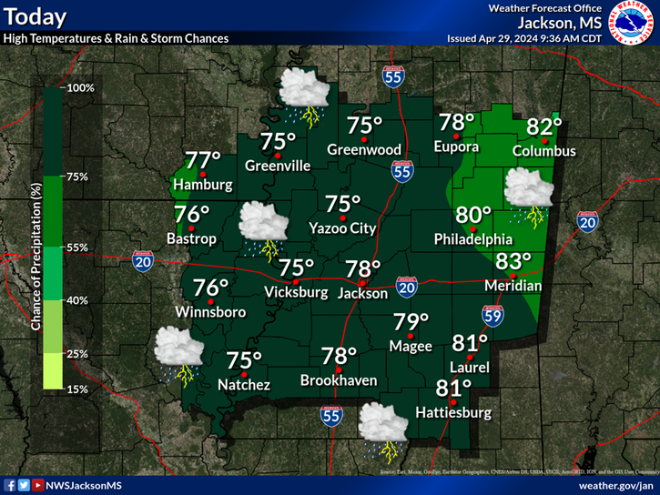
NWS-Jackson MS-This is the place that will get hit hardest

https://www.weather.gov/jan/


NWS Forecast Office Jackson, MS                                            
                    Current Hazards                                                        

  •                
                        Current Conditions                                            
  •             
  •                
                        Radar                                            
  •             
  •                
                        Forecasts                                           
  •             
  •     

Significant severe storms are possible over a large portion of the area this afternoon into early Wednesday morning. Strong tornadoes, some possibly significant and long-tracked, are possible. Please stay weather aware today through early Wednesday morning. Monitor NOAA Weather Radio and local radio and television outlets for the latest weather information, including possible warnings.   

Click a location below for detailed forecast.


Last Map Update: Tue, Nov. 29, 2022 at 7:41:58 am CST


                Local Radar

By metmike - Nov. 29, 2022, 8:56 a.m.
Like Reply

Little Rock AR:

https://www.weather.gov/lzk/


By metmike - Nov. 29, 2022, 9:01 a.m.
Like Reply

Evansville IN, where I live:

Much higher threat SOUTH of us.

https://www.weather.gov/pah/

NWS Forecast Office Paducah, KY


            Weather.gov > Paducah, KY        


  •             
  •                
                        Current Hazards                                            
  •             
  •                
                        Current Conditions                                            
  •             
  •                
                        Radar                                            
  •             
  •                
                        Forecasts                                            
  •                                   
  •         


Click a location below for detailed forecast.


Last Map Update: Tue, Nov. 29, 2022 at 7:46:19 am CST       

Watches, Warnings & Advisories                                                                                                


            Special Weather Statement                            


            Hazardous Weather Outlook                            


Weather Story


                Weather MapWeather Map            


                Local Radar Image


By metmike - Nov. 29, 2022, 2:13 p.m.
Like Reply

Action is picking up now in the south. Should stay active well into the night.

Go to the link below,

 Then you can hit any spot on the map, including where you live and it will go to that NWS with all the comprehensive local weather information for that/your county/region. 

https://www.weather.gov/                                                                                                                 


Latest National radar images


https://www.wunderground.com/maps/radar/current


Static mapCA - BakersfieldNY - BinghamtonND - BismarckNH - BerlinTX - BrownsvilleKY - Bowling GreenMI - CadillacNC - CharlotteGA - ColumbusOH - DaytonCO - DenverIA - Des MoinesFL - Key WestVA - RoanokeCT - HartfordMO - Jefferson CityOK - LawtonNE - North PlatteAR - Little RockMT - LewistownLA - New OrleansID - McCallFL - Saint PetersburgSD - PierreAZ - PrescottUT - ProvoOR - RedmondWY - RivertonNV - RenoNM - RoswellTX - San AntonioVA - StauntonKS - SalinaIL - SpringfieldMN - Saint CloudWA - TacomaMS - Vicksburg


            This link below provides some great data. After going to the link, hit "Mesoanalysis" then,  the center of any box for the area that you want, then go to observation on the far left, then surface observations to get constantly updated surface observations or hit another of the dozens of choices.

https://www.spc.noaa.gov/


 Northwest Southwest Central Plains Northern Plains Southern Plains Midwest East Central Northeast Southeast 
Found a great new link/site that shows us how much precip fell(from 1 hr to 72 hours) for different periods to share with you.
https://www.iweathernet.com/total-rainfall-map-24-hours-to-72-hours
Data Update Cycle: The 1-hr mosaic is updated every 5 min (approx). All other mosaics are now updated hourly, including the 48h and 72h maps.
The site does not allow me to copy the actual images/data here, as we do with all the other links above..........so just go to the link!

By metmike - Nov. 29, 2022, 4:51 p.m.
Like Reply
By metmike - Nov. 29, 2022, 5:03 p.m.
Like Reply
By metmike - Nov. 30, 2022, 1:05 a.m.
Like Reply

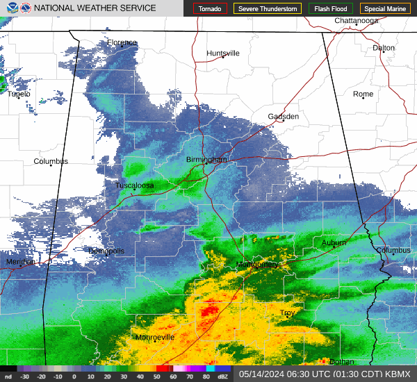
Following the storms farther east from the Birmingham NWS:

https://www.weather.gov/bmx/


Severe storms are likely across Central Alabama through 8 AM Wednesday. Risks include tornadoes, damaging winds up to 70 mph, and hail up to ping pong ball size.


                Local Radar

By metmike - Nov. 30, 2022, 1:11 a.m.
Like Reply

Here's Atlanta:

https://www.weather.gov/ffc/


L                                                                                                                                                                                        

                KFFCRadar

By metmike - Nov. 30, 2022, 1:12 a.m.
Like Reply

Excessive rain threat.

https://www.wpc.ncep.noaa.gov/qpf/excess_rain.shtml


Current Day 1 ForecastCurrent Day 1 Excessive Rainfall Forecast

By metmike - Nov. 30, 2022, 12:31 p.m.
Like Reply