Severe Storm Risk......updated daily(days 1 and 2 twice daily).
https://www.spc.noaa.gov/products/outlook/
Current Day 1 Outlook | |
Current Day 2 Outlook | |
Current Day 3 Outlook | |
Current Day 4-8 Outlook |
Excessive rain threat.
https://www.wpc.ncep.noaa.gov/qpf/excess_rain.shtml
Current Day 1 Forecast
Day 1 Threat Area in Text Format
Current Day 2 Forecast |

To see rain amounts, go here: https://www.iweathernet.com/total-rainfall-map-24-hours-to-72-hours
You can scroll down and get almost the entire comprehensive weather picture updated constantly here.
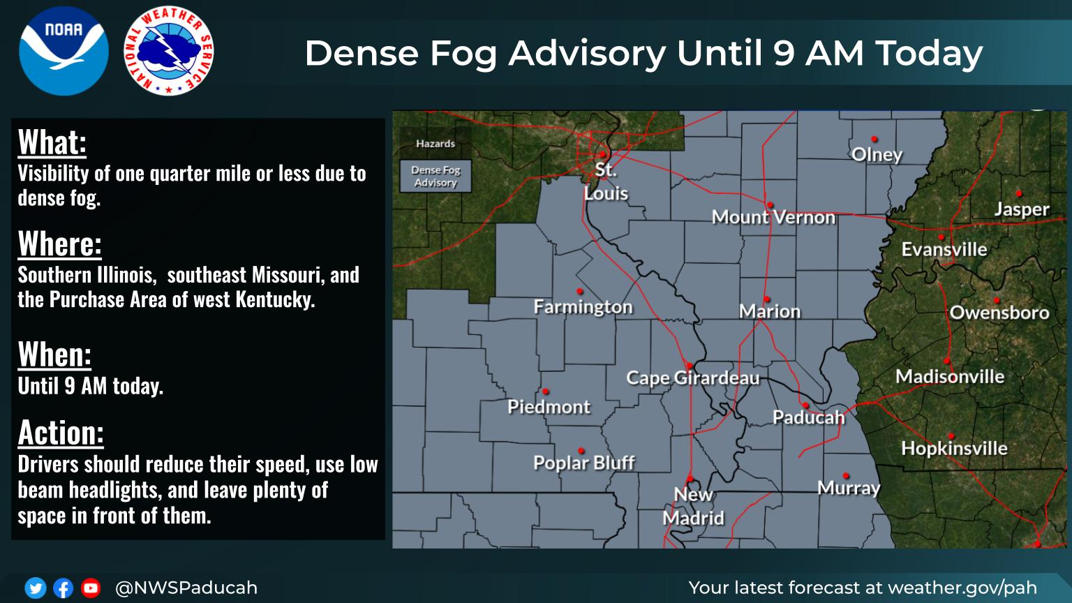
Current Hazards at the link below.
Go to the link below, hit hazards box in the top right hand corner(it will also define all the color codes), if its not already in the hazards mode when you load the link.
Then you can hit any spot on the map, including where you live and it will go to that NWS with all the comprehensive local weather information for that/your county.

Latest National radar images
https://www.wunderground.com/maps/radar/current

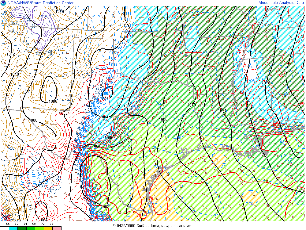
This link below provides some great data. After going to the link, hit "Mesoanalysis" then, the center of any box for the area that you want, then go to observation on the far left, then surface observations to get constantly updated surface observations or hit another of the dozens of choices.
 Found a great new link/site that shows us how much precip fell(from 1 hr to 72 hours) for different periods to share with you. https://www.iweathernet.com/total-rainfall-map-24-hours-to-72-hours Data Update Cycle: The 1-hr mosaic is updated every 5 min (approx). All other mosaics are now updated hourly, including the 48h and 72h maps. The site does not allow me to copy the actual images/data here, as we do with all the other links above..........so just go to the link! |
Current Conditions below updated every few minutes.
UPPER MIDWEST
https://www.spc.noaa.gov/exper/mesoanalysis/new/viewsector.php?sector=13#


https://www.spc.noaa.gov/exper/mesoanalysis/new/viewsector.php?sector=13#

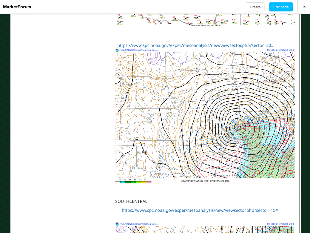
LOWER MIDWEST
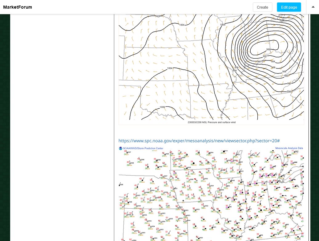
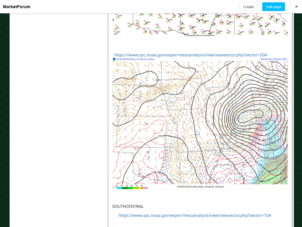
https://www.spc.noaa.gov/exper/mesoanalysis/new/viewsector.php?sector=20

https://www.spc.noaa.gov/exper/mesoanalysis/new/viewsector.php?sector=20#

https://www.spc.noaa.gov/exper/mesoanalysis/new/viewsector.php?sector=20# 
SOUTHCENTRAL
https://www.spc.noaa.gov/exper/mesoanalysis/new/viewsector.php?sector=15#
SOUTHEAST
https://www.spc.noaa.gov/exper/mesoanalysis/new/viewsector.php?sector=18#

More weather here:
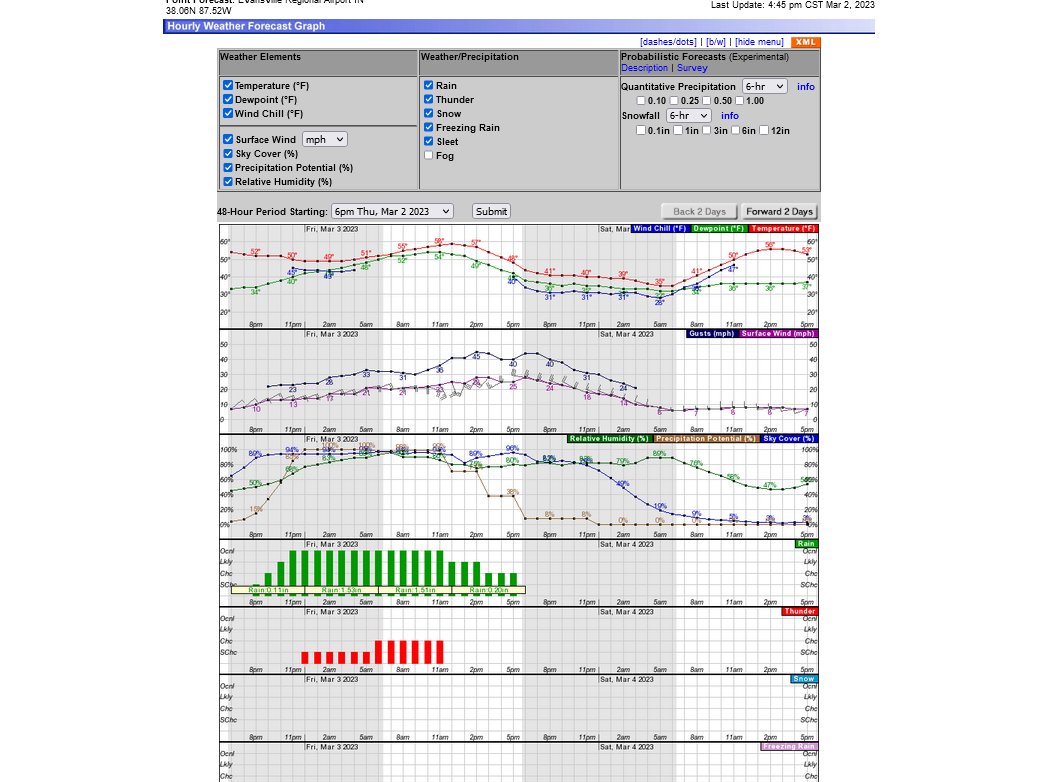
Evansville IN weather:
1. 2-4 inches of rain overnight Thursday/ Friday morning
2. Severe weather risk Friday morning
3. E winds increase Friday morning. Shift to S with wind gusts above 40 mph by noon. Quickly shifting SW with gusts close to 50 mph possible in the early afternoon. Shifting W then NW by late afternoon with gusts close to 50 mph still possible. Gradually diminishing Friday Night.
4. Sunny and pleasant with light winds on Saturday, High 56. Perfect for a chess tournament!
https://www.marketforum.com/forum/topic/92277/
Click a location below for detailed forecast.
https://forecast.weather.gov/MapClick.php?lat=38.05&lon=-87.53&unit=0&lg=english&FcstType=graphical
Over 3.5 inches of rain so far.
We had a huge oak tree fall across our driveway early this morning )-:
Just a radar indicated rotation NOT a violent tornado
Wind gusts could still be 80 mph and a weak tornado could spin up that reaches the ground with 100+ mph winds.
+++++++++++
Severe Weather Statement National Weather Service Paducah KY 1230 PM CST Fri Mar 3 2023
INC129-163-KYC101-031900- /O.CON.KPAH.TO.W.0021.000000T0000Z-230303T1900Z/ Vanderburgh IN-Posey IN-Henderson KY- 1230 PM CST Fri Mar 3 2023
...A TORNADO WARNING REMAINS IN EFFECT UNTIL 100 PM CST FOR VANDERBURGH...EAST CENTRAL POSEY AND NORTHWESTERN HENDERSON COUNTIES...
At 1229 PM CST, a severe thunderstorm capable of producing a tornado and extensive straight line winds to 80 mph was located near Henderson, moving northeast at 55 mph.
HAZARD...Tornado.
SOURCE...Radar indicated rotation.
IMPACT...Flying debris will be dangerous to those caught without         shelter. Mobile homes will be damaged or destroyed. Damage         to roofs, windows, and vehicles will occur.  Tree damage is         likely.
This dangerous storm will be near...  Kasson around 1235 PM CST.
Other locations in the path of this tornadic thunderstorm include Evansville, Melody Hill and Darmstadt.
This includes the following highways... Interstate 69 in Indiana between Mile Markers 1 and 2, and between Mile Markers 10 and 20. Interstate 64 in Indiana between Mile Markers 17 and 29.
PRECAUTIONARY/PREPAREDNESS ACTIONS...
TAKE COVER NOW! Move to a basement or an interior room on the lowest floor of a sturdy building. Avoid windows. If you are outdoors, in a mobile home, or in a vehicle, move to the closest substantial shelter and protect yourself from flying debris.
The line of main storms will be thru by around 12:50pm and then we will just have very strong gusty winds the rest of the afternoon.
Straight line winds from the SW were gusting to 54 mph at Paducah just beforenoon, so we could easily see wind gusting to 50+ mph in some places this afternoon.
just before Noon, the Evansville winds were still E-14 mph gusting to 25 mph.
The will be almost double that the rest of the afternoon, shifting quickly to the SW then W later.
+++++++
Heavy rains and severe weather risk is over but the high winds and soggy ground could result in some weakly anchored trees or some tree limbs blowing down.
No leaves on the trees makes them less top heavy and reduces that risk.
Just before 1pm readings below:
Current conditions at
Evansville, Evansville Regional Airport (KEVV)
Lat: 38.04°NLon: 87.52°WElev: 417ft.
Thunderstorm in Vicinity Light Rain and Windy
61°F
16°C
Humidity 81%
Wind Speed S 28 G 52 mph
Barometer 28.87 in (977.5 mb)
Dewpoint 55°F (13°C)
Visibility 4.00 mi
Last update 3 Mar 12:54 pm CST
The center of the low was a tad southwest of us! Look at that sub 978 mb pressure reading!!!.png)
Those are snapshots. The latest current weather maps are here:
Here's the 5pm snap shot isobars/conditions: