See good advice and information from the major outbreak that just ended that should be applied to the next one(and others):
Severe weather outbreak likely on Friday(3-31-23)!
Started by metmike - March 27, 2023, 4:21 p.m.
https://www.marketforum.com/forum/topic/94148/
+++++++++++++
Next one that we've been discussing has moved up to day 4 from the progression of days, today on Saturday, April 1, 2023(Happy April Fools Day but this is no joke):
The large 30% area for day 4 is likely to end up having some moderate risk in it as we get closer. The event looks extremely similar to this last one. There will be strong tornado potential again!
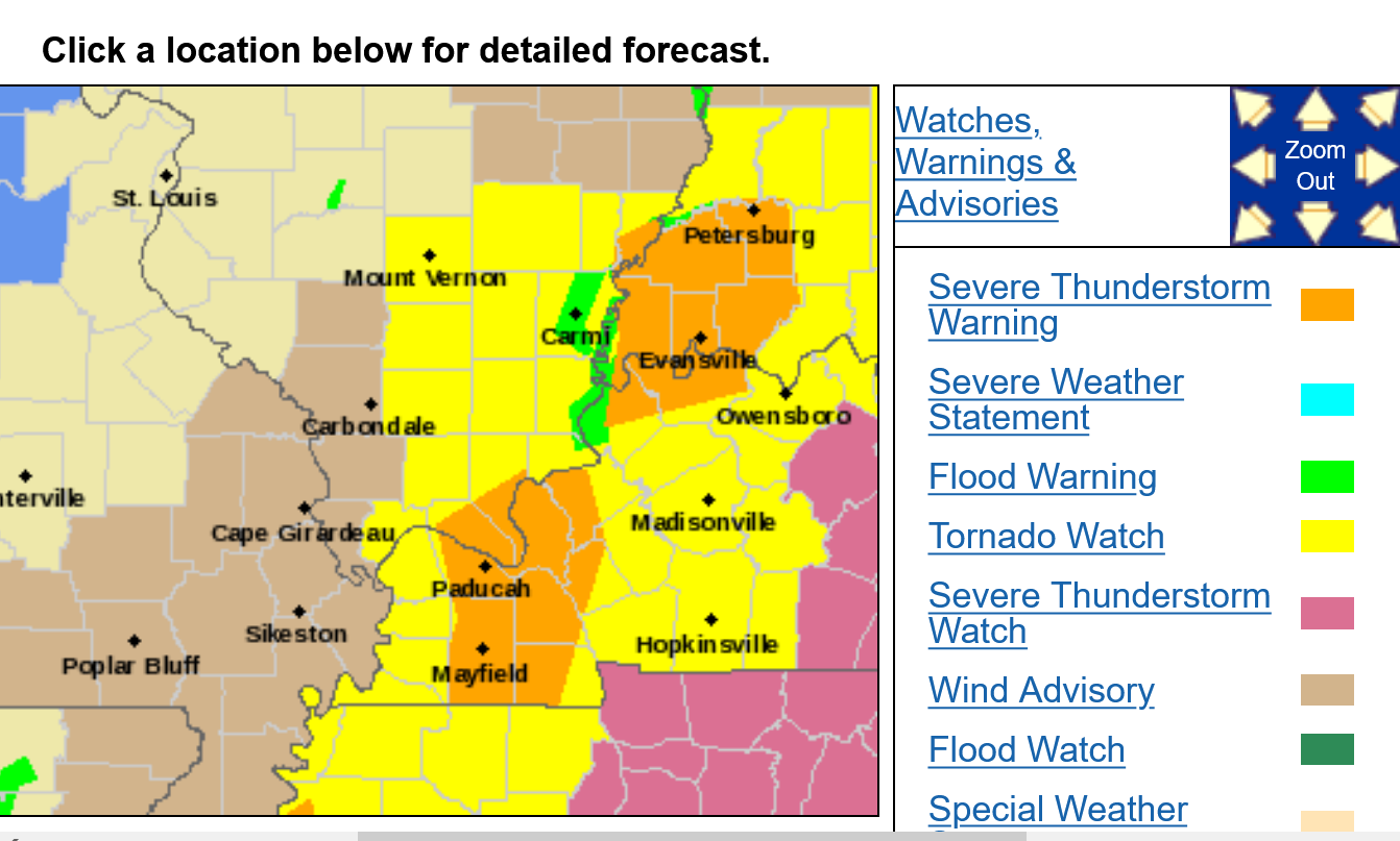
Severe Storm Risk......updated daily(days 1 and 2 twice daily).
https://www.spc.noaa.gov/products/outlook/
Current Day 1 Outlook | |
Current Day 2 Outlook | |
Current Day 3 Outlook | |
Current Day 4-8 Outlook |
Entire comprehensive weather pages, constantly updated here:
https://www.marketforum.com/forum/topic/83844/
Previous severe weather discussion:
https://www.marketforum.com/forum/topic/93984/
More atmospheric rivers/La Nina is dead
https://www.marketforum.com/forum/topic/93716/
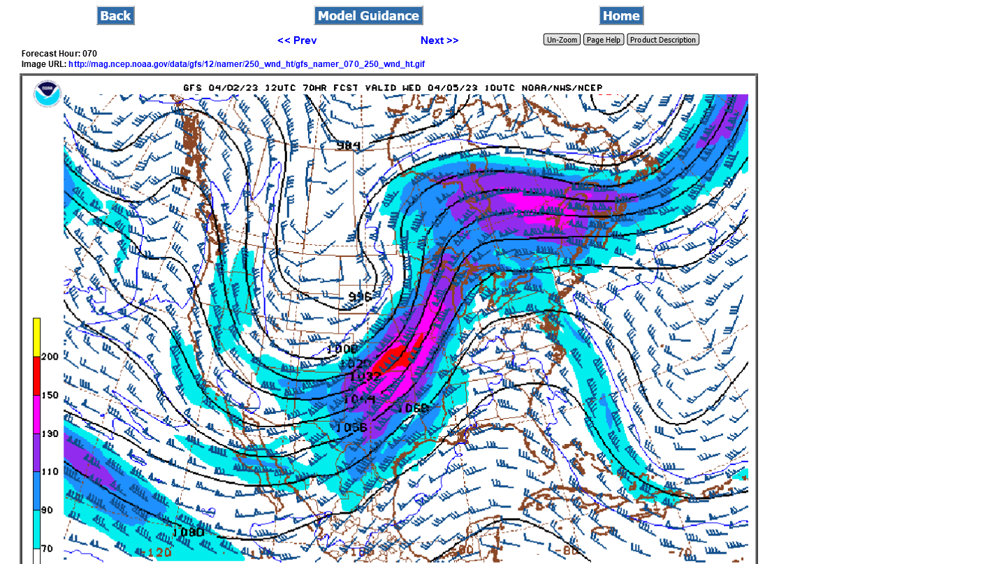
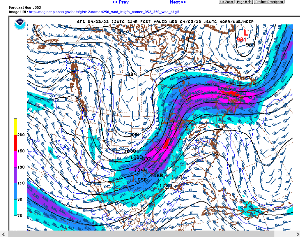
This is the forecast for Tuesday Night from the last 12z GFS run from 4-1-23.
Impressive jet stream at 250 mb/34,000 feet means intense storms with some tornadoes a given. The 150 knot red shade of the jet max in the center is 180 mph! That's some pretty strong upper level divergence(that causes lift and rising air) and a textbook severe weather outbreak signature with potential strong tornadoes.
Still unknown are details on lower levels and their likely interaction with this powerful jet stream.
I've seen 200 knot jet streaks before which would be the yellow, so this isn't the MOST powerful ever but it's up there and will likely produce widespread severe weather, including violent tornadoes because of the laws of physics and meteorology.
Use the tables at this link:
https://www.marketforum.com/forum/topic/93984/#94059
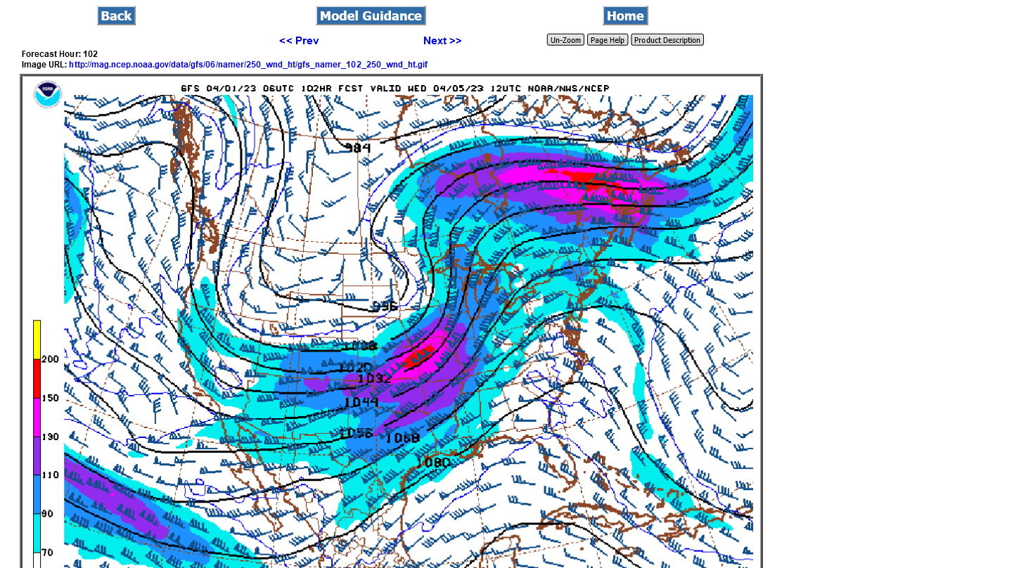
Compare this forecast map above to the forecast map from this last event.
WOW! If Jet streams had families, these would have the same mommy and daddy (-:
Note also below, the jet stream streak in the top left corner. That one, is the next one coming up as it appeared 5 days ago on forecast maps we showed here on March 27th. The maps above are the same everything......except they came from a model run. today on April 1, vs the model run below on March 27th(5 days ago).
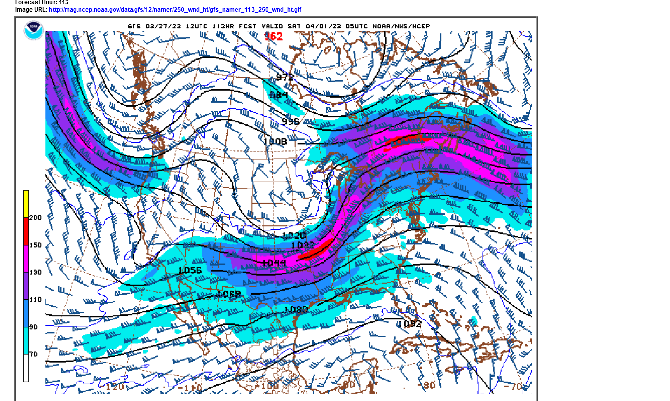
Note on the TOP map above, there isn't another storm coming upstream.
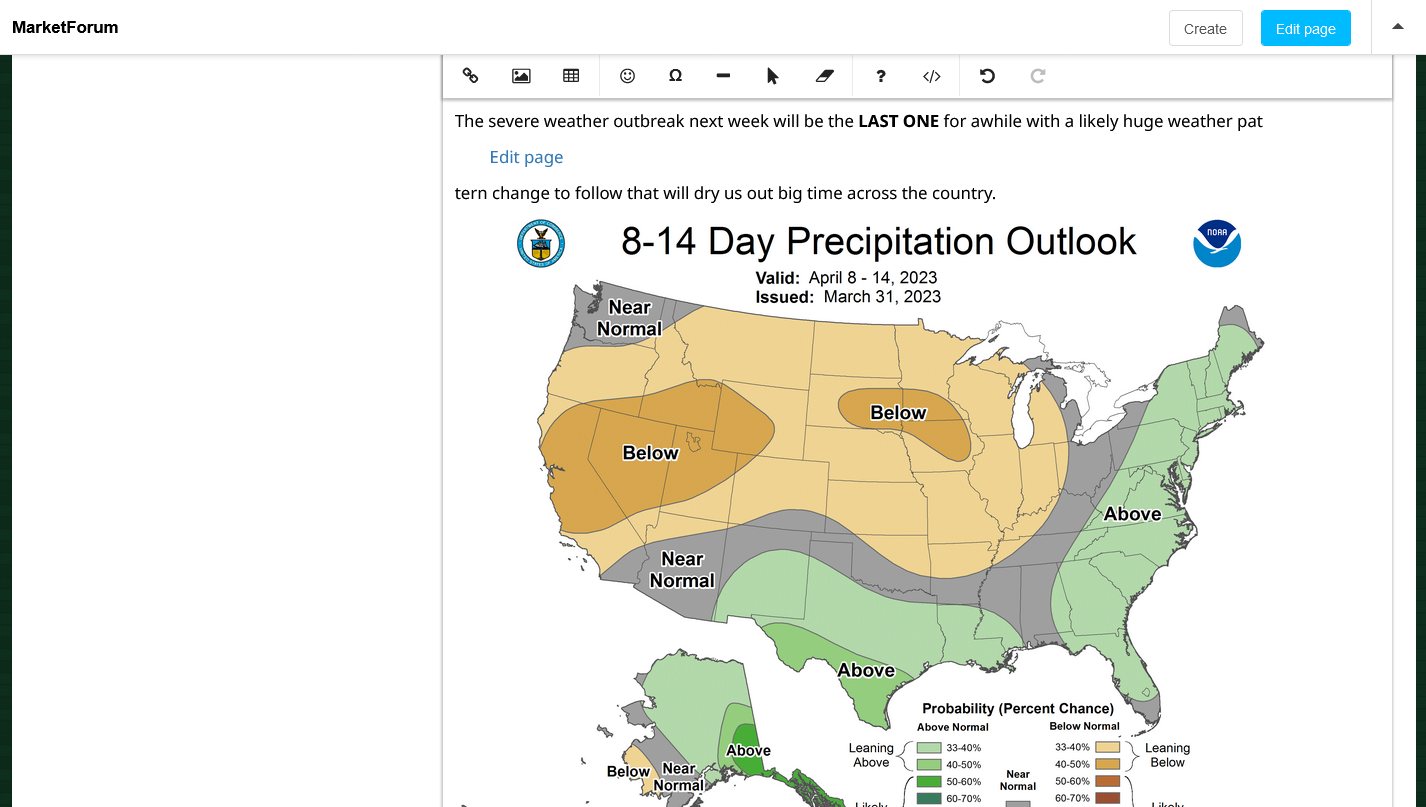
The severe weather outbreak next week will be the LAST ONE for awhile with a likely huge weather pattern change to follow that will dry us out big time across the country.
https://www.cpc.ncep.noaa.gov/products/predictions/814day/index.php
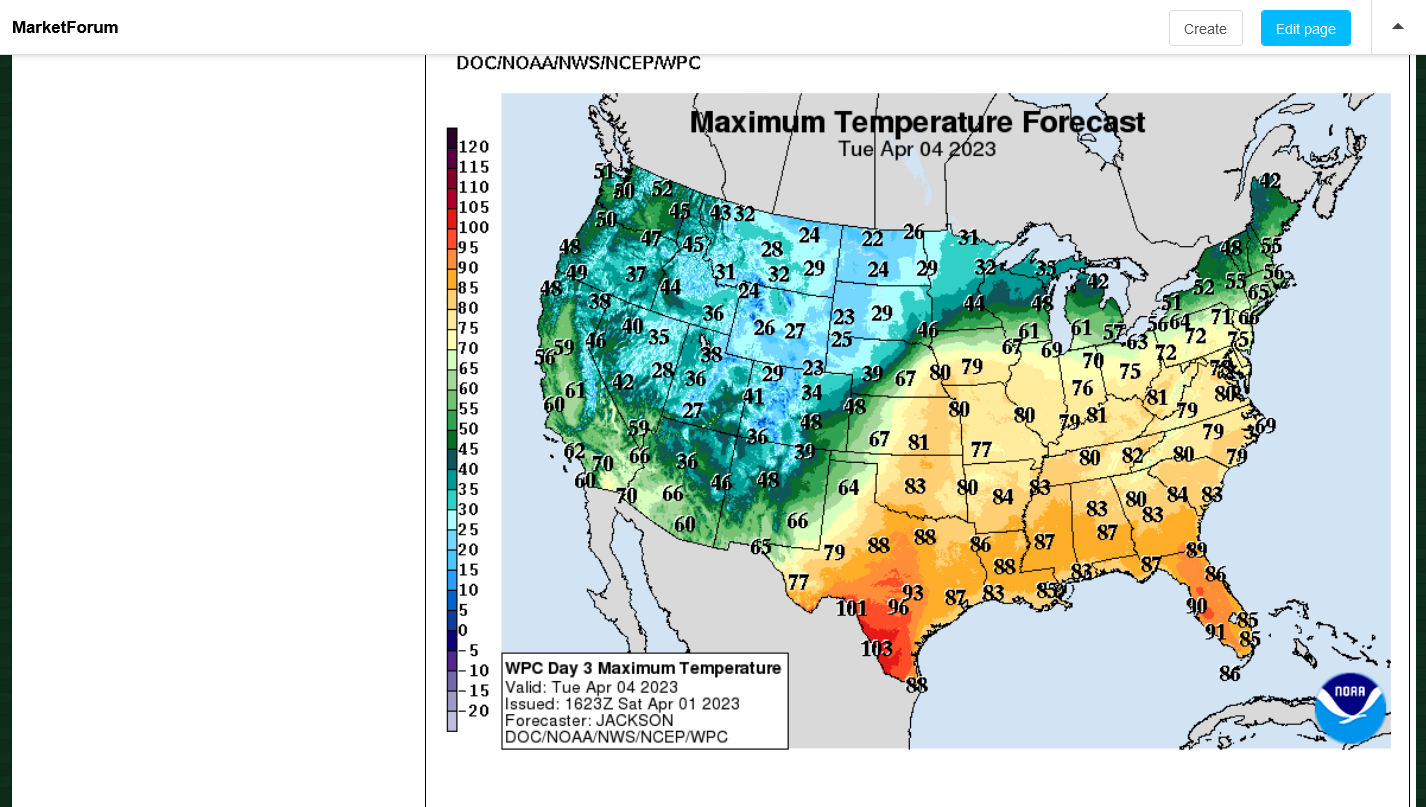
Look at the incredible temperature disparity with the forecast highs next Tuesday:
80's on the warm side of the storm, 20's on the cold side.
In fact, southeast NE could get up to 80 degrees, while in the northwest part of the same state, temps will be in the 20's!
The strongest Mid latitude jet streams over land, usually track right along the steepest temperature gradients.
Generally speaking, the steeper the temperature gradient, the stronger the jet stream can be.
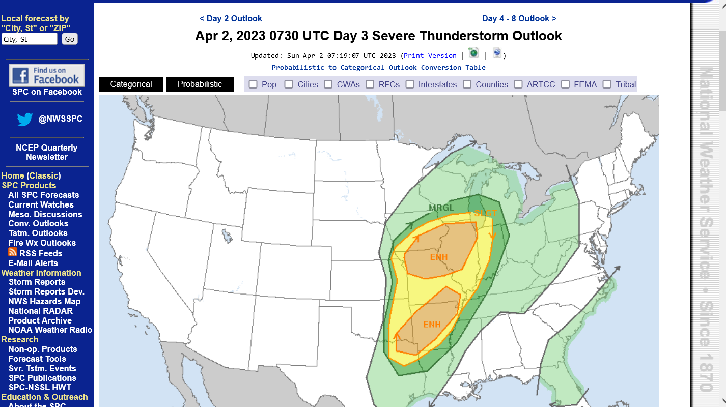
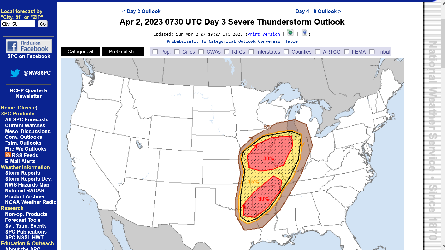
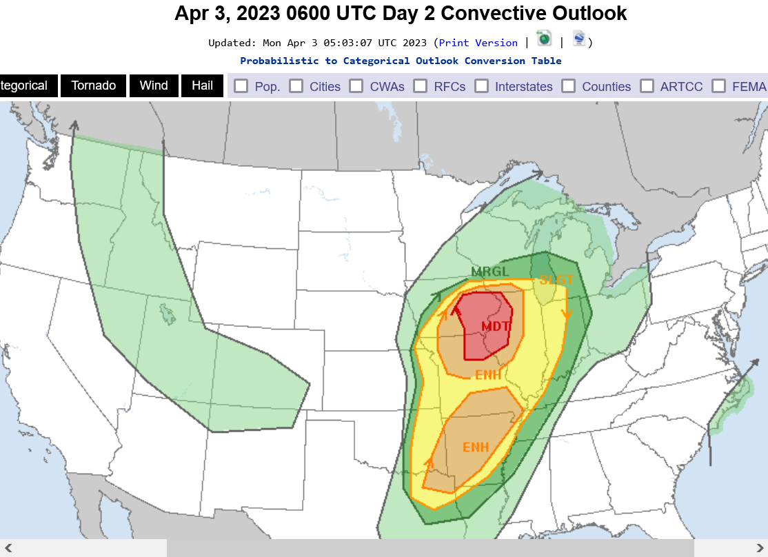
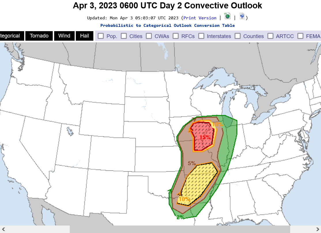
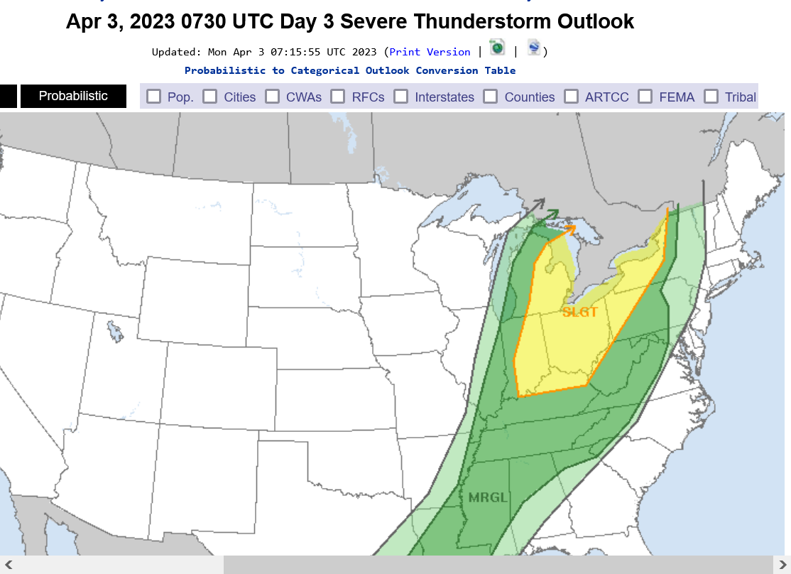
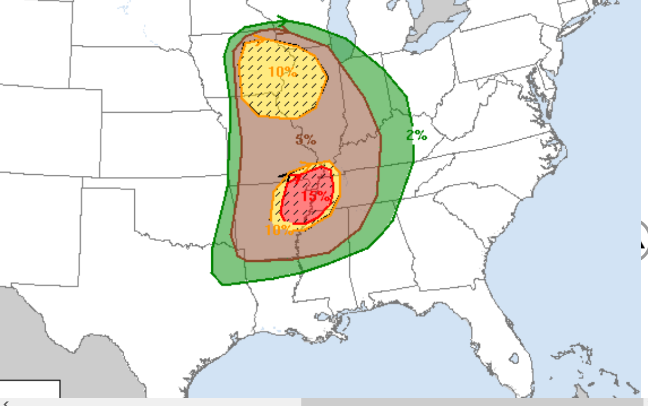
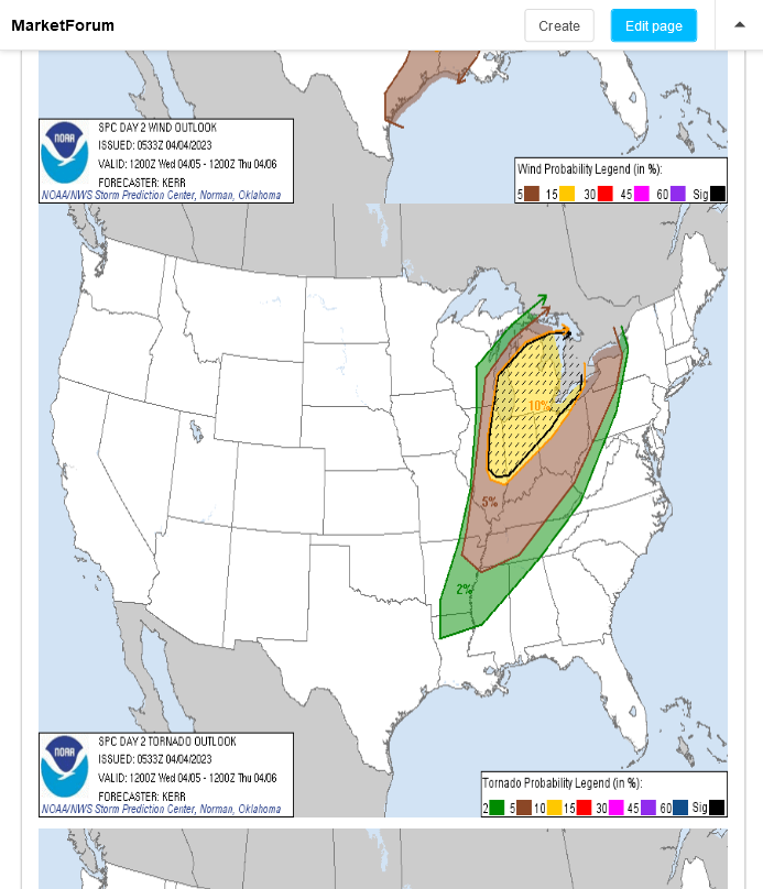
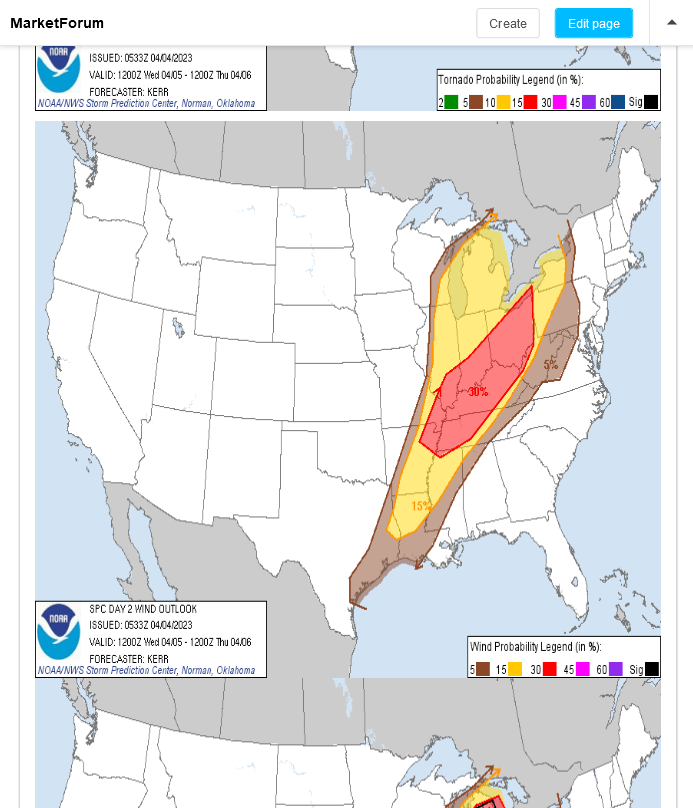
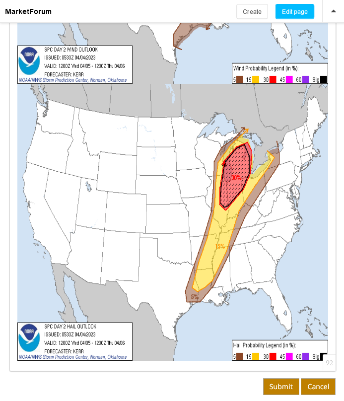
The next severe weather outbreak is day 3 in the forecast. Day 2 is when they will break down the probabilities for each category but this is what they show today for day 3.
Extremely similar to the last event. 2 separate areas of higher, 30%+ risk.
They will almost certainly have some moderate risk again, probably starting tomorrow/Monday. Can't rule out some high risk again when we get close. These are frozen images that don't update below to lock them in so they correspond with the descriptive verbiage in this post after these products get updated.
https://www.spc.noaa.gov/products/outlook/day3otlk.html
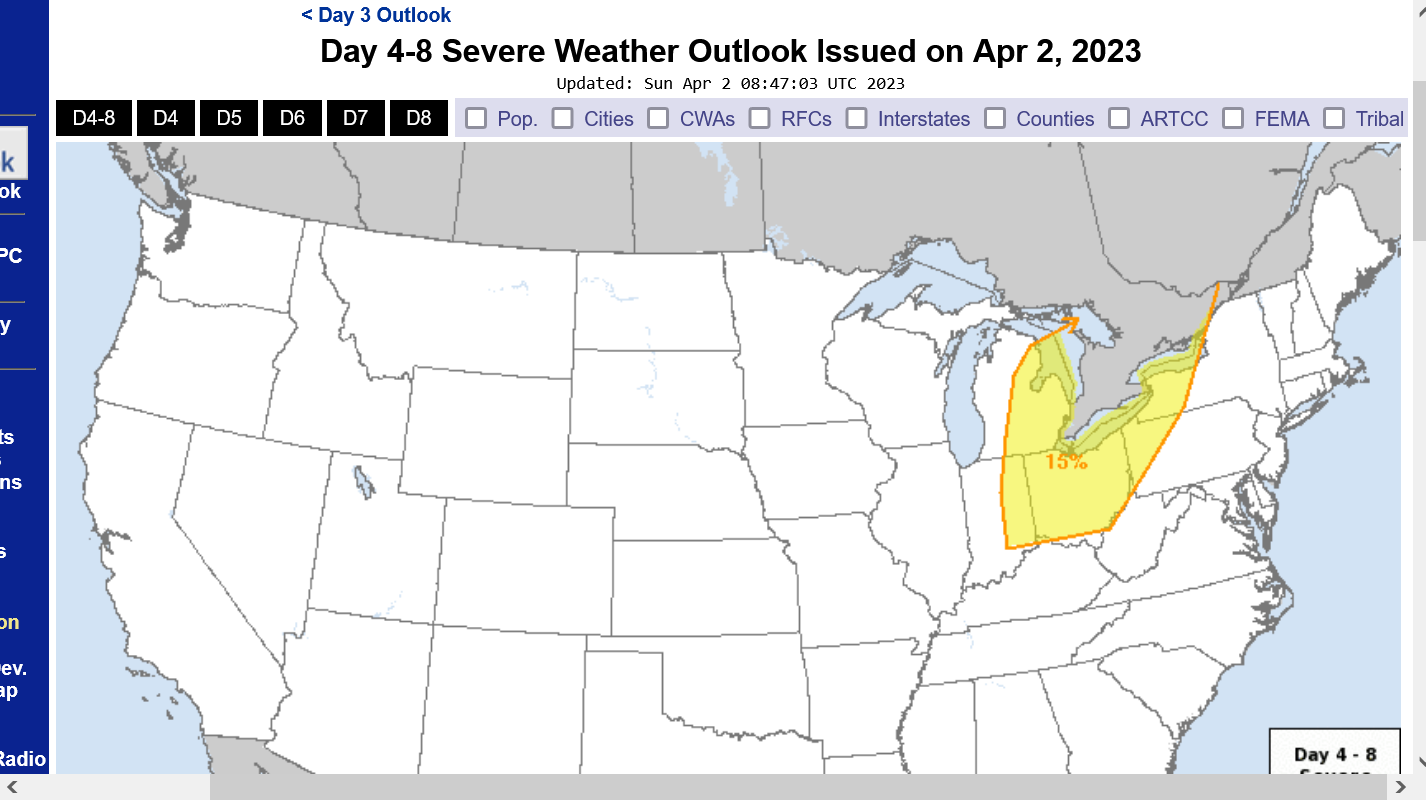
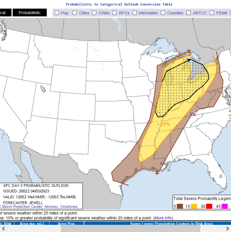
Day 4, Wednesday, April 5th below
I have some adjustments to the forecast from a day ago. The last 12z GFS model below has a stronger jet max vs yesterday. Now up around 195 mph and the upper level ridge ahead of the storm builds more. This slows it down and deepens the upper level trough associated with the system, which amplifies the south to north component in wind ahead of the storm, along with some severe weather intensity metrics.
This DELAYS the severe weather risk into later Wednesday morning for Indiana compared to the last day 4 map on the previous page.
The upper level chart below for early April 5, 2023 is a textbook, widespread severe weather outbreak with some decent long track violent tornado potential, especially along and just west of the Mississippi River.
I included the previous system below.
Note the MUCH stronger upper level ridge ahead of this next storm at the top and MUCH deeper upper level trough/low that is forced farther west by the ridging on that top map. So the severe weather outbreak will initiate farther west by several hundred miles on Tuesday. It will also be MUCH warmer in locations farther northwest with this next system consistent with these dynamics at the surface.
Higher heat and humidity spell more instability for many places. The good news for places like Evansville, IN is that the system will be coming thru at a time of day(early am) that features a big drop from the daytime peak in instability. We will also be farther east of the main violent tornado generating dynamics. At the same time, we never want to see any risk of late night/pre-dawn violent tornadoes because sleeping people are the least informed on urgent weather warnings.
Regardless of differences outlined above, there are still a tremendous amount of similarities as you can see.
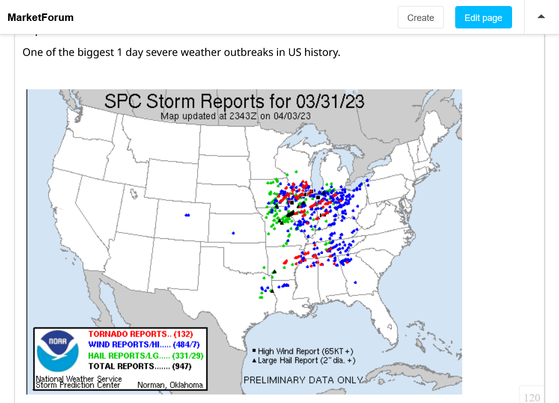
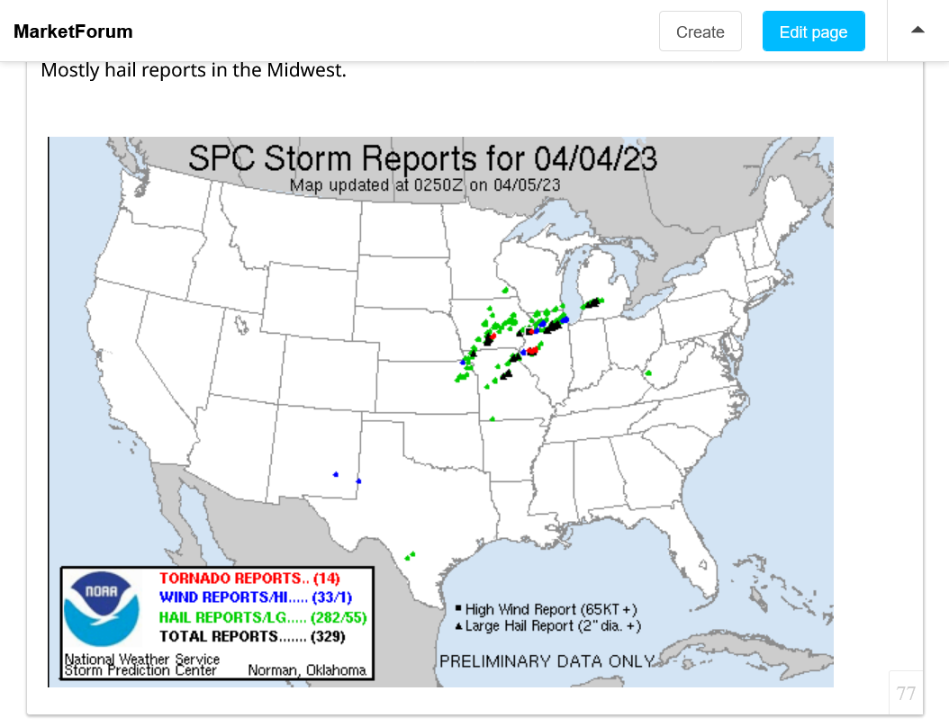
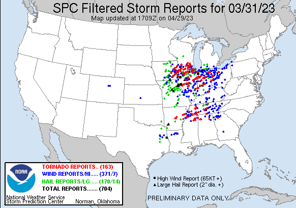
Just a reminder of what the last system did. Updated with additional reports from that day.
https://www.spc.noaa.gov/climo/reports/230331_rpts.html
Tornadoes =132
Wind =484
Hail =331
Total severe weather reports =947
There will be a similar severe weather outbreak on Tue/Wed............then the following 2 weeks should be very quiet and mostly dry across the entire country.
Update: the next event will be farther west and NOT as many reports.
Good news for places like Evansville In, with regards to the next severe weather outbreak and what we suspected earlier.
1. This current system is s bit farther west and the strongest upper level dynamics are a bit northwest of the previous one.
2. This one is big. The main cold front triggering severe weather will be going thru at a more stable time of day(morning Wed) and also be getting farther and farther away from the best upper level support to the west. Still a decent risk but the risk will be dropping east of the Mississippi River.
3. This introduces a new element for our schools that wasn't there last time. Classes will be in session on Wednesday morning. Even though the risk of a warning(especially for a violent tornado) will be MUCH LOWER at that time compared to Tuesday PM/the day before, farther to the east there is a chance the schools may need to respond to a warning on Wednesday morning. They already practice this and know what to do.
4. There were no violent tornadoes this far east/away from the main systems greatest dynamics during the last 2 events! That's pretty much a meteorology 101 principle. It's still possible but when the storms move east of the main jet stream core dynamics, it gets harder and harder to generate violent, long track tornadoes! Violent, long track tornadoes are what kill the majority of people.
https://www.spc.noaa.gov/products/outlook/
1. Categorical risk from Tue 7am to Wed 7am.
2. Tornado risk
3. Severe thunderstorm risk
4. Hail risk
5. Categorical risk from Wed 7am to Thu 7am.

https://www.npr.org/2023/03/27/1166209327/tornadoes-climate-change-mississippi-alabama
"The observational record is not consistent and relatively short, the models remain inconclusive as to replicating tornado activity, and our understanding of how global warming and climate change will influence the different atmospheric processes that produce tornadoes (wind shear, for example) is more limited," reads a page on its website
++++++++++++++++++++++++
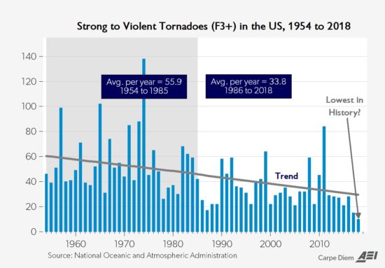
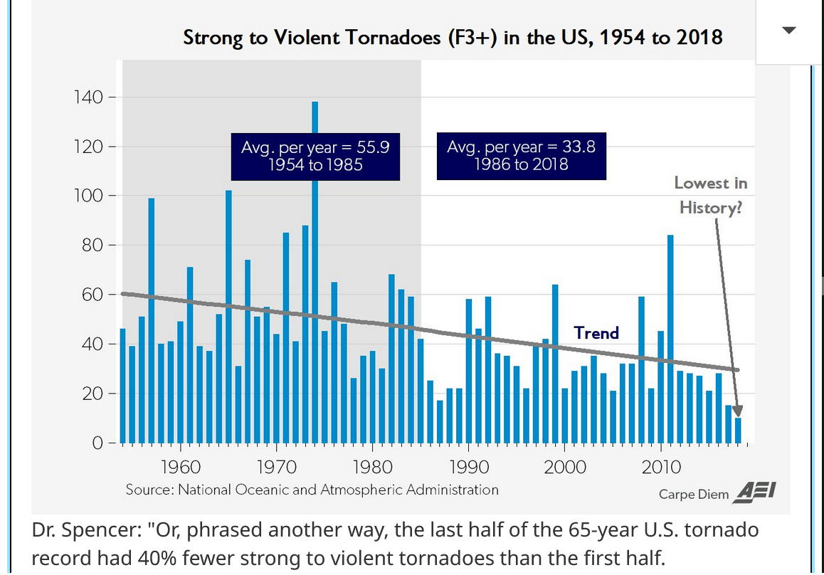
Let me make it easy on you, NPR(trying to hide the beneficial fact about climate change below) with 1 graph. Keep in mind that weak tornadoes have doubled since the 1990's entirely because of NEXRAD Doppler radars being able to detect all those brief, previously unreported tornadoes. Strong/violent tornadoes don't need radar verification.
Climate change, by warming the coldest places the most and decreasing the temperature gradient has indisputably DECREASED tornadoes(principle of meteorology 101), especially the strongest ones.
https://www.drroyspencer.com/2019/05/recent-tornadoes-are-due-to-unusually-cold-weather/
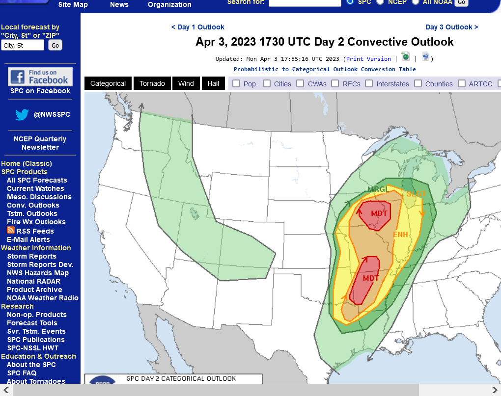
I've been waiting for the just updated Severe Storm Prediction Centers update and it confirms my thinking. Seemingly small changes having huge potential impacts in the forecast for Indiana.
Here's the updated maps with the relevant points:
1. Categorical risk for Tuesday including all elements of severe weather-updated
2. Tornado risk for tomorrow/Tuesday just updated
3. Tornado risk-from the previous storm at the same time frame-analysis below.
https://www.spc.noaa.gov/products/outlook/day2otlk.html
Tornado risk, day 2 outlook below-just updated
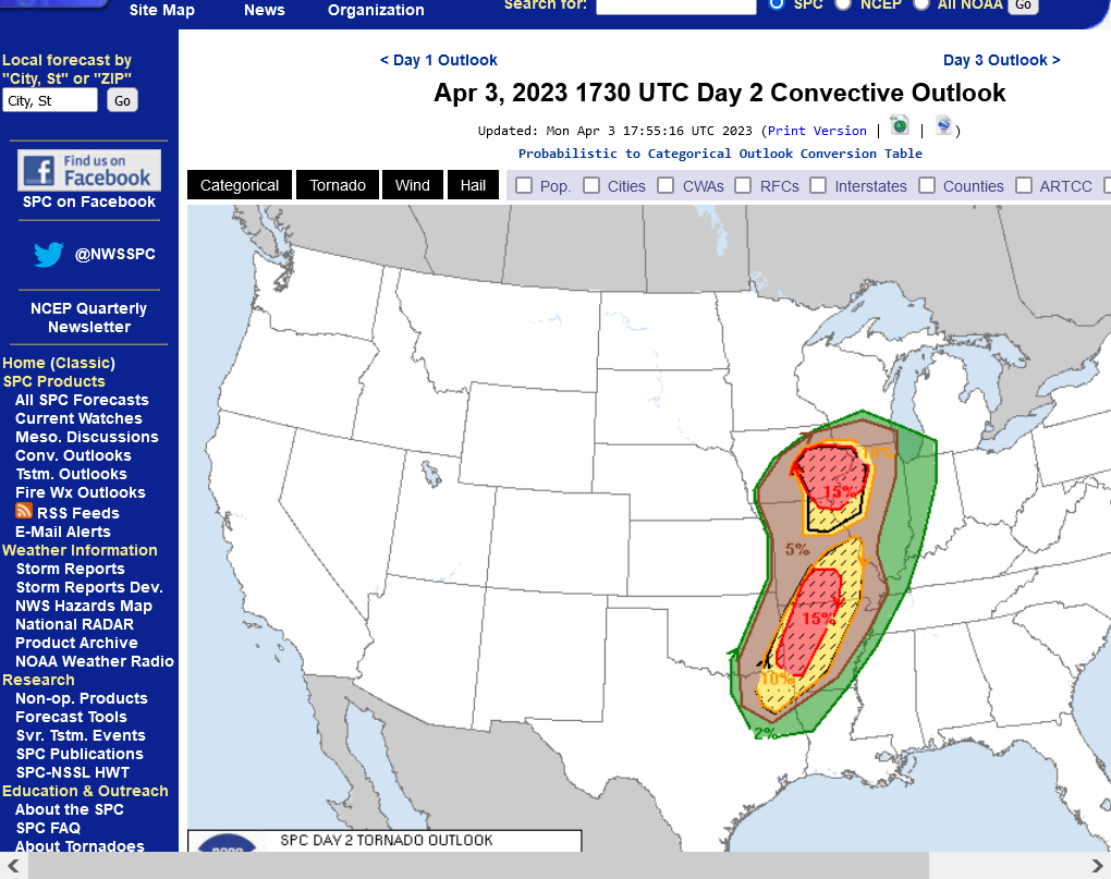
Previous system tornado risk for similar day 2 outlook(from last Thursday)
Note that the 2nd map above-just updated has a much larger red hatched/higher risk zone for tornadoes tomorrow. However the southern part of the risk area has been shifted 300+ miles W/SW, putting western IN barely in the 2% risk compared to well above 5% with the last one. While this doesn't rule out a strong tornado, the dynamics suggest a 3-4 times LOWER threat of a violent tornado this time for Indiana compared to last time. DO NOT interpret that to mean the risk is off because it's still there....just much less.
+++++++++++++++++++++++
Supporting that outlook on the just updated 2nd map above is the jet stream forecast below for late morning on Wed/4-6-23. This is from the just out 12z run of the GFS model.
Note the location of the red/pink/purple that define a very powerful jet stream, 150 knots(180+ mph) at the core. It's 300+ miles west of Indiana.
IN is on the outside edge in light blue. Less than 50% the strength/wind velocity at 90 mph. This equates to much less lifting and rotating in the atmosphere below. Still a severe weather type signature but for Indiana in a location of weakening mode and rapidly losing support for a strong tornado.
The map above for this storm coming up is textbook for strong tornadoes WEST OF Indiana with a much lower risk in our state. Compare to the one below from the last storm.
Below, is the same jet stream map when the last storm hit. Purple was in Indiana with pink and red aimed at us-adding to the lift!! Elevated potential for strong tornadoes for Indiana on 3-31-23!
Risk area for Wednesday. This will mainly be for damaging winds in a severe thunderstorm and NOT from a strong tornado in Evansville but that can't be ruled out.
Not much change in the big picture but some new. specific details for the Wednesday outlook.
Wednesday will feature a continuation of the severe weather outbreak that will start later today, Tuesday.
Severe storms may be ongoing early in the day. Models have this system moving SLOWER than earlier in the week, so in Evansville this extends the risk well into the PM hours.
We should emphasis that severe thunderstorms do alot of damage but rarely kill people......and almost never if they are in their safe place. Weak tornadoes(which are the vast majority) don't result in many fatalities and almost never for those in their safe place.
It's the strong tornadoes EF2s and higher with winds of 111+ mph and especially EF3s of 136+ mph or stronger that cause almost all the fatalities.
The good news is that we can almost always detect those stronger ones the best and warn with the greatest amount of time. Often, greater than 30+ minutes advance warning. So people paying attention to the latest weather have plenty of time to go to their safe place before a strong tornado hits. Being in your safe spot, even during a strong tornado greatly decreases the odds of serious harm.
Wednesday does have a continued risk(from Tuesday) for strong tornadoes in few locations, especially in the S.Great Lakes.
Most tornadoes are EF0s and EF1s.
| EF Number | 3 Second Gust (mph) |
0 | 65 to 85 |
1 | 86 to 110 |
2 | 111 to 135 |
3 | 136 to 165 |
4 | 166 to 200 |
5 | Over 200 |
Maps below:
1. Categorical-includes all 3 risks combined on 1 map
2. Tornado risk-highest risk north of Ohio Valley in S. Great Lakes-10% chance of a tornado within 25 miles of any point- 5+% chance along the Ohio River. Strong tornado is possible
3. Severe thunderstorm wind risk-highest in Ohio Valley-30% chance of an event within 25 miles of any point.
4. Hail risk-30% chance of large hail within 25 miles of any spot in the S.Great Lakes.
https://www.spc.noaa.gov/products/outlook/day2otlk.html
1. Categorical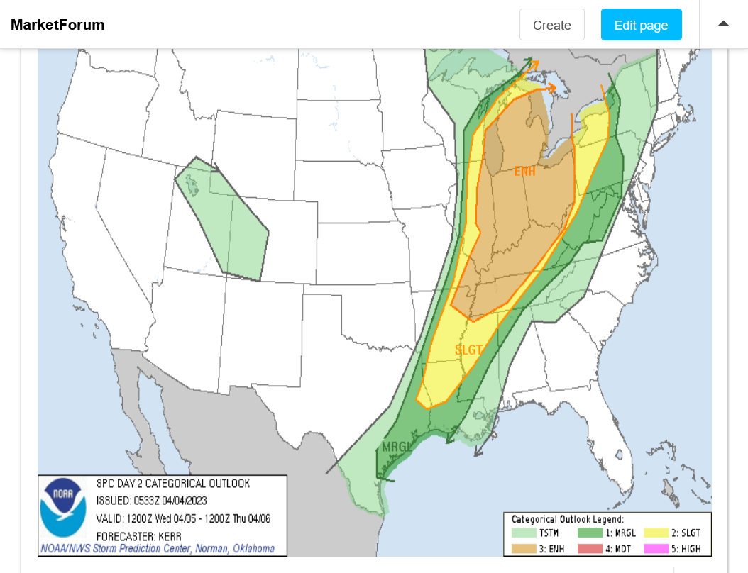
Tornado risk below-highest S.Great Lakes-strong tornado still possible and also possible farther south with less risk
Severe thunderstorm risk below-highest Ohio Valley-severe storms don't kill and rarely hurt people in their safe place. Just a tremendous amount of damage
Hail risk below-highest in S.Great Lakes
You can track this storm right now, live with all the constantly updated data at this link:
https://www.marketforum.com/forum/topic/83844/
Day 1, Tuesday outlook just updated. This is the risk of tornadoes between now and Wednesday, early morning. The hatched areas could feature strong tornadoes.
In MO/AR tonight, we are expecting potential, nocturnal super cells with potential strong tornadoes.
https://www.spc.noaa.gov/products/outlook/day1otlk.html
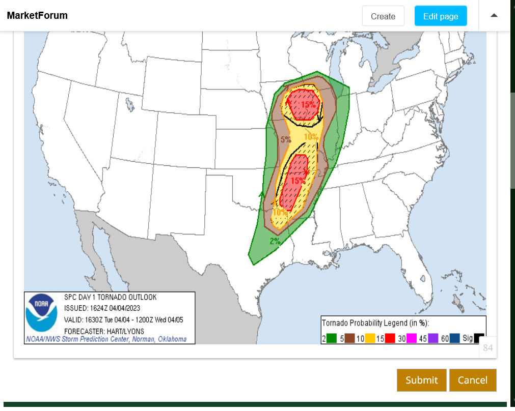
So far, tonight it's not been extremely active as of 10pm!
You can track this storm right now, live with all the constantly updated data at this link:
https://www.marketforum.com/forum/topic/83844/
Evansville IN weather page.
With the system continuing to slow down, we expect Wednesday afternoon to be the highest risk time frame. 60+ mph winds in a severe thunderstorm are the greatest threat then. 35% chance of this within 25 miles of your location.
However, there is still, roughly a 5% chance of a tornado within 25 miles of your location and we can't rule out a strong tornado.

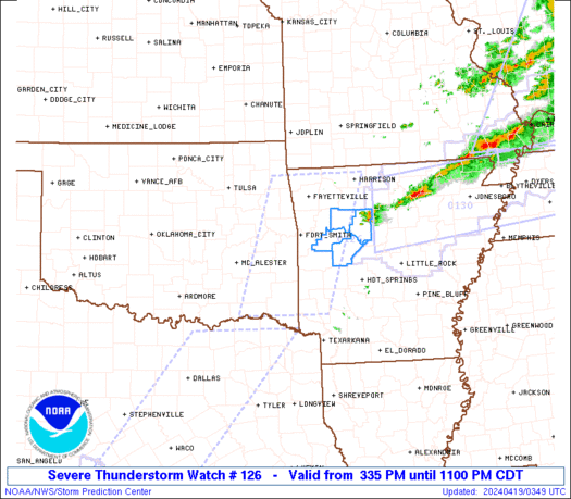
Tornado watches just issued for our area until 4 and 5pm. The storms and severe weather risk will have passed east of here by then. Between now and then, we just track the actual storms and get ready to go to a safe place if a tornado warning is issued. Though the risk for a strong tornado is less than last Friday, that sounds misleading because there still is a 5% change of a tornado within 25 miles of any point in Evansville.
Track the local weather here:
https://www.marketforum.com/forum/topic/94270/#94350
This one is until 4pm
https://www.spc.noaa.gov/products/watch/ww0126.html
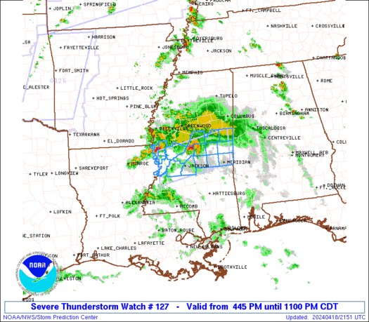
This one is until 5pm.
|
|
|
https://www.spc.noaa.gov/products/watch/ww0127.html
https://www.spc.noaa.gov/products/watch/
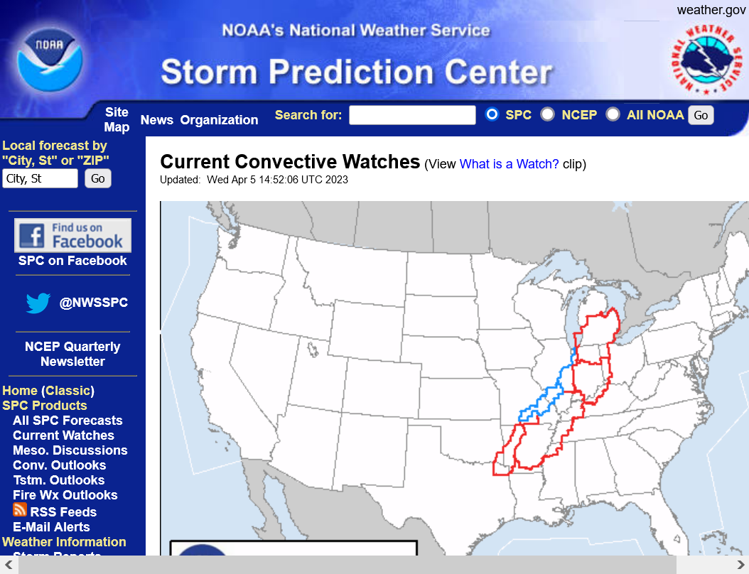
https://www.spc.noaa.gov/products/outlook/day1otlk.html
Tornado risk below for today

Damaging wind risk below

Tornado
Chance of EF0-EF1 tornado is 5%+ today. Winds less than 111 mph.
Chance for an EF2+ (strong) tornado is LOW today. Winds of 111+ mph
Severe thunderstorm
Chance of 78+ mph wind is LOW today.
Chance of 58-78 mph thunderstorm wind today is HIGH=30% within 25 miles of you
Hail
Chance of hail less than 2" is moderate
Chance of hail greater than 2" is low
Most tornadoes are EF0s and EF1s.
| EF Number | 3 Second Gust (mph) |
0 | 65 to 85 |
1 | 86 to 110 |
2 | 111 to 135 |
3 | 136 to 165 |
4 | 166 to 200 |
5 | Over 200 |
More on tornadoes here"

With todays Doppler radar technology, strong tornadoes will NOT just pop up out of nowhere within a few minutes before warnings are issued.
There are distinct radar signatures that ALWAYS show up well before the tornado becomes strong and the NWS will ALWAYS put out a tornado warning before the tornado becomes strong that will ALWAYS allow people in the path, who are monitoring those warnings to go to their safe place.
We are getting some atmosphere stabilizing rain shortly after noon that reduces the risk of severe weather slightly as the main line approaches.
No severe weather yet but an ornery looking cell in SW Illinois right now.
Update 3 minutes later.........we just got a warning for the one in SW Illinois.
Those are part of an organizing line headed northeast, aimed at Evansville in LESS THAN 2 hours. Watch the radar and stay tuned for warnings when/if they get close.
OK, these storms are flying. May be here in an hour.
1:30pm: This intensifying line of storms has has resulted in numerous SEVERE THUNDERSTORM warnings to our southwest. No tornado detected rotation. Main threat is winds gusts to 60+ MPH unless they develop more. They will likely cause a fw to numerous warnings in our area., starting any time now.
I'll be at North JH/HS chess starting at 2pm and not posting much.
1:35pm: View from Evansville radar, farther north. Yellow boxes are severe thunderstorm warnings. We should be getting a bunch of them/multiple counties shortly. The storms are rapidly strengthening and organizing into a line, just to our west moving northeast but the line is moving east. The rain earlier helped to stabilize the atmosphere a bit.
1:55pm Severe thunderstorm warning Evansville and a dozen other counties in the area. Main threat is 60 mph winds. No tornadoes reported or seen on radar.
Back from chess practice.
As we suspected this event has not featured many tornadoes. Mostly severe thunderstorms with high winds.
Several reports came from the Evansville below, including a wind gust of 62 mph at the airport. Just 1 tornado in southwest KY.
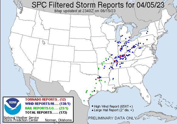
Reports so far today, April 5, 2023
https://www.spc.noaa.gov/climo/reports/today.html

Severe reports Evansville below
| 1913 | UNK | 2 N EVANSVILLE | VANDERBURGH | IN | 3801 | 8755 | WIRES DOWN ON KANSAS ROAD & SEVERAL TREES DOWN ON KREMER ROAD. (PAH) | |
| 1916 | UNK | 2 E DARMSTADT | VANDERBURGH | IN | 3809 | 8753 | LARGE TREE DOWN. (PAH) | |
| 1917 | 62 | EVANSVILLE | VANDERBURGH | IN | 3798 | 8754 | MEASURED AT THE EVANSVILLE AIRPORT ASOS. (PAH) |
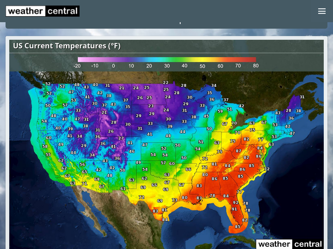
Pretty amazing temperature contrast on either side of the system right now:
https://www.weathercentral.com/weather/us/maps/current-temperatures
Severe weather reports from this last event using filtered reports, which greatly reduces the numerous reports pouring in close to each other.
https://www.spc.noaa.gov/faq/#6.11
Filtered: The space/time filtering had been used by SPC in an attempt to reduce duplicate reports and limit artificially inflated initial estimates of severe weather events when many reports arrived for the same event. The filtering is applied to each of the tornado, hail, and wind reports separately.
The logic implemented for filtering is as follows:
The filtering logic is applied to tornado, hail, and wind reports separately. For example, a tornado report and hail report for the same location and time are kept in their respective reports.
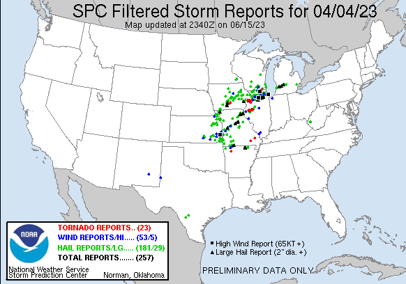
https://www.spc.noaa.gov/climo/reports/230405_rpts.html
Look at the reports from the previous event, 5 days earlier. The most I remember in 1 day and it might be an all time record for this region.
https://www.spc.noaa.gov/climo/reports/230331_rpts.html
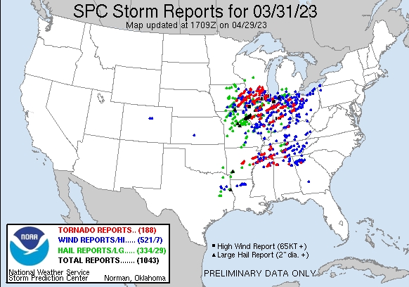
Here's the unfiltered reports for March 31, 2023.
1,028 of them!!!
This report is very enlightening for weather nuts like WxFollower and metmike!
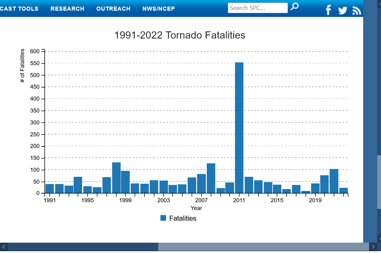
https://www.spc.noaa.gov/media/year-in-review/

2011 fatalities below were elevated by the outbreak that resulted in the Joplin MO tornado that was at extraordinary EF5 intensity(200+ mph) for awhile.
From 2019 below:
Recent Tornadoes are Due to Unusually Cold Weather
https://www.marketforum.com/forum/topic/31370/#31626
https://www.drroyspencer.com/2019/05/recent-tornadoes-are-due-to-unusually-cold-weather/
https://www.wunderground.com/cat6/an-historical-look-at-f5-ef5-tornadoes
Arguably, the most intense weather event that takes place on Earth is the rare occurrence of a tornado that reaches EF5 strength on the Enhanced Fujita Scale (or F5 on the original Fujita Tornado Damage Scale). Winds within these monsters have been measured as high as 302 mph by Doppler radar (Bridge Creek, Oklahoma, on May 3, 1999, pictured above) but winds likely have exceeded 300 mph on other occasions in tornadoes that were not so closely observed.
For the period 1991-2010, the U.S. reported an average of about 1250 tornadoes (of all classifications, including EF0) per year, according to the NOAA National Centers for Environmental Information. Only about 0.06% of all tornadoes are classified as F5 or EF5. That’s about one tornado out of every 1,666.
+++++++++++
I know this one below extremely well. As chief meteorologist for WEHT in Evansville, I did several reports on the anniversary of The Great Tri-State Tornado, including interviewing survivors of it from completely destroyed Griffin IN. They had some vivid memories with many in school that day.
The one I remember the most, was a lady that was a child at the time, who stated in 1990 that after it hit, everybody was just running around aimlessly in every direction, screaming and crying. She said that she thought one of them was a "negro" but then realized there were people covered in mud that got picked up from the Wabash River 2 miles to the west.
For the interviews, I got together half a dozen or so and it was a wonderful reunion of people recalling an historic event in amazing, fascinating detail, talking about what it was like back in an era with much less technology and none for weather detection/warning.
My Dad is 97 years old and I'll be in Detroit to visit him in 2 weeks. Still plays chess! It's awesome to hear his stories about growing up in the inner city of Detroit, 90 years ago, never even meeting his dad. Even if hearing them several times before. He turned out to be the best dad on the planet!
We have some really bad people with too much power in this world but the science, technology and medicine we are blessed with today, make 2023 a place that allows us to do and accomplish things that people in 1925 couldn’t dream of!
The ”single” deadliest tornado in U.S. history was the famous Tri-State Tornado of March 25, 1925. At least695 people died in Missouri, Illinois, and Indiana when a F5 mile-wide monster carved a course that was apparently 219 miles through the three states. Modern research, however, suggests that this was likely a series of tornadoes developing from a single supercell traversing the area. A 2013 study led by Robert Johns found that the longest truly continuous damage path was 151 miles long, from central Bollinger County, Missouri, to Pike County, Indiana.
At least eight other violent (F2 or stronger) tornadoes killed an additional 52 people in Alabama, Tennessee, and Kentucky over the course of that day, bringing the total killed to 747 and making this the single deadliest tornado outbreak in American history.
 The path of the Tri-State Tornado (at times rated as a F5) of March 18, 1925, in its full, originally calculated length of 219 miles. Subsequent research found that the longest unbroken damage path within this track was apparently 151 miles long. This was the deadliest single tornado in U.S. history. Murphysboro, Illinois, saw 234 people lose their lives, the largest number of fatalities related to a single tornado on record for any U.S. community. The Weather Channel produced a short documentary about the historic storm; see https://www.youtube.com/watch?v=M3dbojUnl5I. (Graphic courtesy “Illinois Tornadoes”, by John W. Wilson and Stanley A. Changnon, Jr., Illinois State Water Survey [1971]).