Starting a new thread for the VERY WINTRY weather coming up this week.
+++++++++++++++++++++
Previous weather thread:
Snow event 1-6-2024
11 responses |
Started by metmike - Jan. 2, 2024, 1:21 p.m.
https://www.marketforum.com/forum/topic/101595/
+++++++++++++++++++
THE COLD COMING UP THIS WEEKEND AND NEXT WEEK WILL BE BRUTAL!!
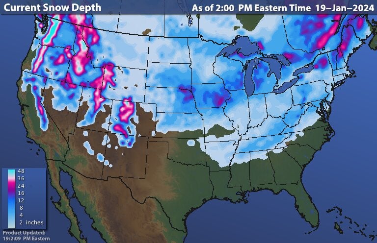
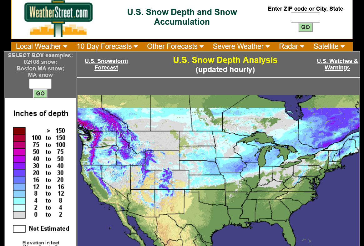
This was the total snow from the Winter storm this past weekend:
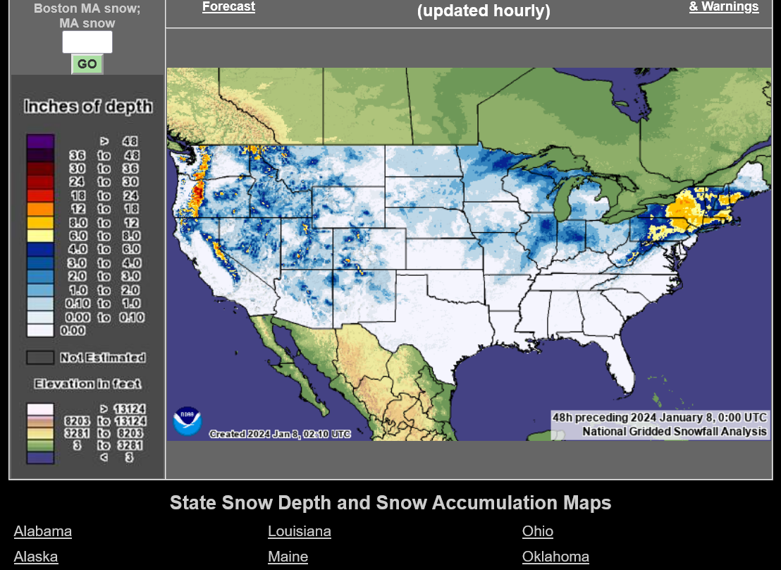
https://www.weatherstreet.com/weather-forecast/Snow-Depth-US.htm
++++++++++++++++
You can use that source to get other information too, like 24 hour snow totals for each state(that just fell).
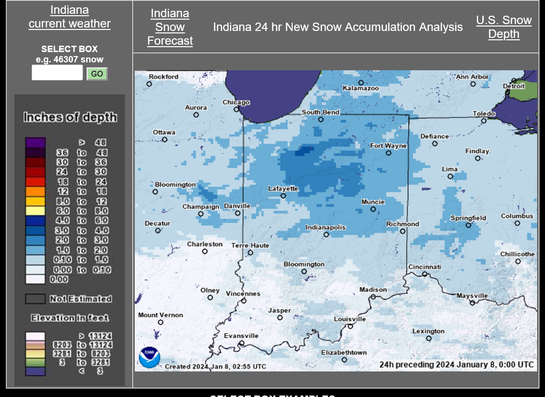
https://weatherstreet.com/weather-forecast/indiana-snow-cover.htm
Time to look ahead. As advertised the last few weeks, January is going to be a VERY snowy month and we've barely started.
We have 2 more Major Winter Storms this week, the first one just started:
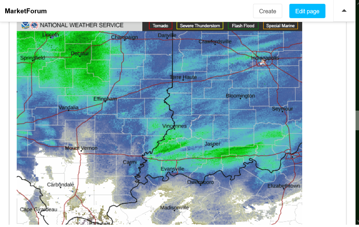
Current Hazards at the link below.
Go to the link below, hit hazards box in the top right hand corner(it will also define all the color codes), if its not already in the hazards mode when you load the link.
Then you can hit any spot on the map, including where you live and it will go to that NWS with all the comprehensive local weather information for that/your county.

New radar product below
Go to: "Select View" then "Local Radar"
Hit the purple circle to see that local radar site
+++++++++++++++++++++++
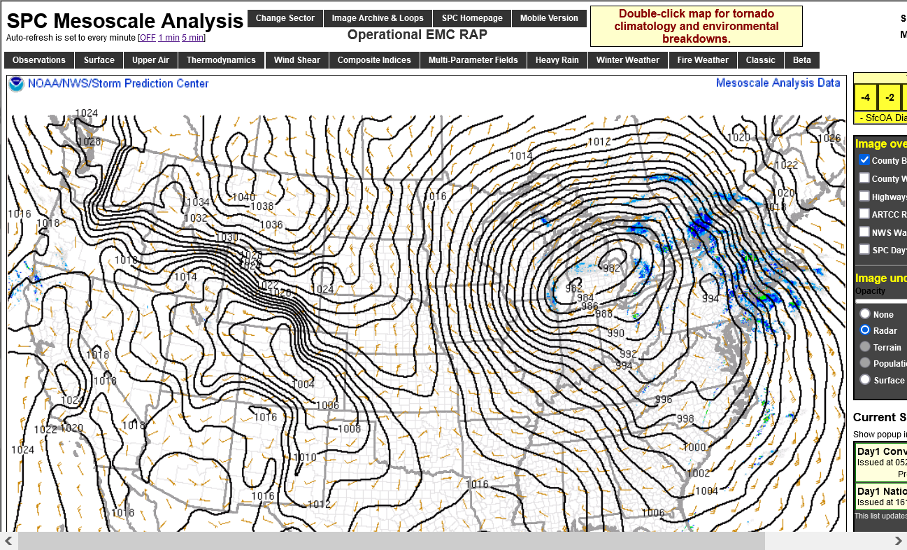
This link below provides some great data. After going to the link, hit "Mesoanalysis" then, the center of any box for the area that you want, then go to observation on the far left, then surface observations to get constantly updated surface observations or hit another of the dozens of choices.
 |
++++++++++++++++++
Current Conditions below updated every few minutes.
UPPER MIDWEST
https://www.spc.noaa.gov/exper/mesoanalysis/new/viewsector.php?sector=13#


https://www.spc.noaa.gov/exper/mesoanalysis/new/viewsector.php?sector=13#

LOWER MIDWEST
https://www.spc.noaa.gov/exper/mesoanalysis/new/viewsector.php?sector=20

https://www.spc.noaa.gov/exper/mesoanalysis/new/viewsector.php?sector=20#

https://www.spc.noaa.gov/exper/mesoanalysis/new/viewsector.php?sector=20# 
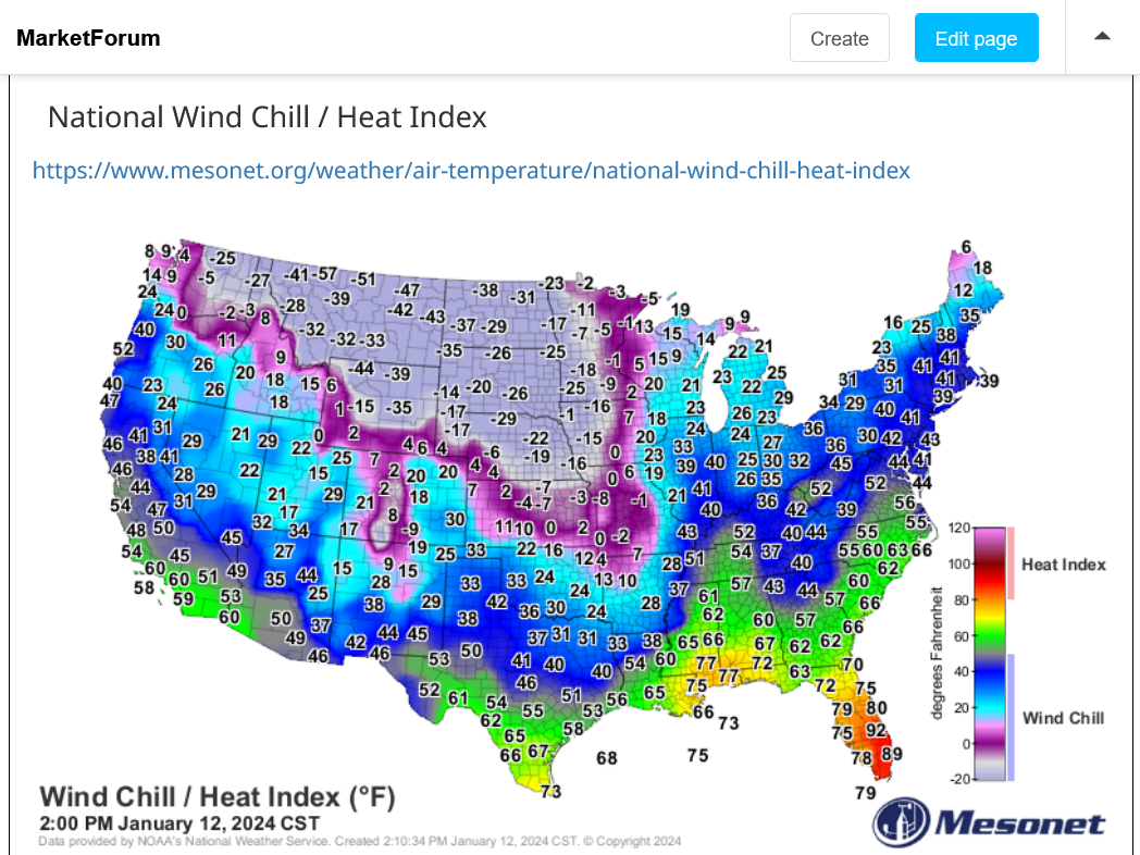
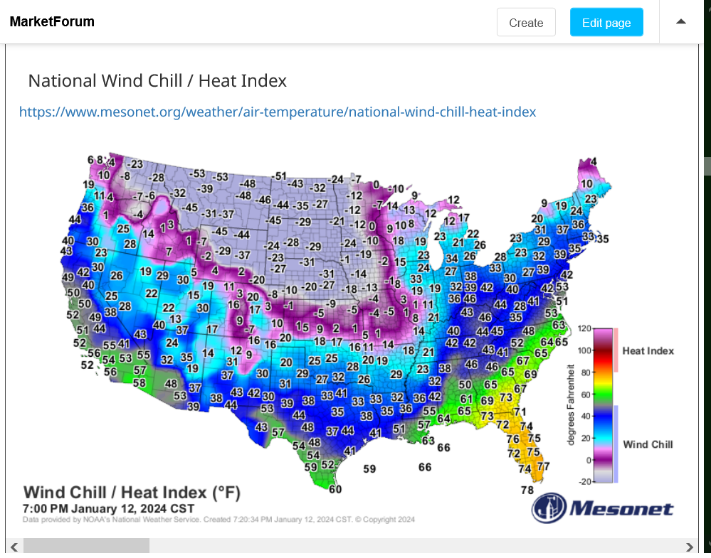
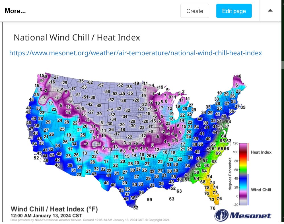
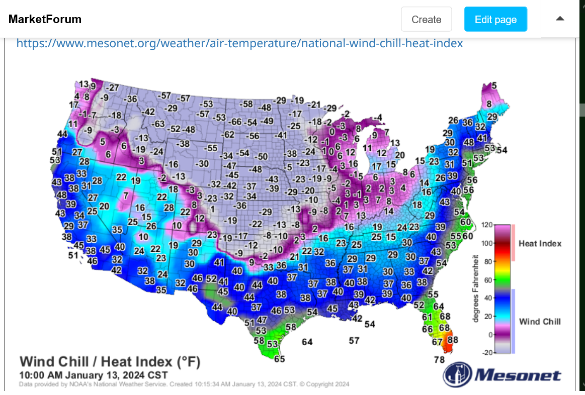
Current temperatures:
https://www.mesonet.org/weather/air-temperature/national-wind-chill-heat-index
1. Weather map now.
2. In 24 hours and
3. In 48 hours.
https://www.wpc.ncep.noaa.gov/#


+++++++++++++++++++++++++++++++++++++++++++++++++
Surface Weather maps for days 3-7 below:
https://www.wpc.ncep.noaa.gov/medr/medr.shtml

These maps can give you a great idea on the areas expecting snow this week and how much.
The NWS will update these products a couple of times/day numerous hours AFTER the updated models are out.
http://www.wpc.ncep.noaa.gov/wwd/winter_wx.shtml
Snowfall Probability Forecasts
The following charts depict the probability of snowfall reaching or exceeding the specified amount.
|
| Specific accumulation thresholds for Days 1-3: | All accumulation thresholds for: | |
| ≥ 1 inch | ≥ 8 inches | Day 1 |
| ≥ 2 inches | ≥ 12 inches | Day 2 |
| ≥ 4 inches | ≥ 18 inches | Day 3 |
| ≥ 6 inches | ||
| Day 1 | Day 2 | Day 3 |
≥ 4 inches | ≥ 4 inches | ≥ 4 inches |
≥ 8 inches | ≥ 8 inches | ≥ 8 inches |
≥ 12 inches | ≥ 12 inches | ≥ 12 inches |
24-, 48-, and 72-Hour Snowfall Percentile Accumulation Forecasts for Days 1-3
Day 4-7 Outlook
|
On the back side of these Winter Storms, there will be some FRIGID air pouring down from very high latitudes.
WIND CHILLS IN INDIANA WILL BE DR0PPING BELOW ZERO BY LATE SATURDAY!!
Lows days 3-7 below:
https://www.wpc.ncep.noaa.gov/medr/medr_min.shtml


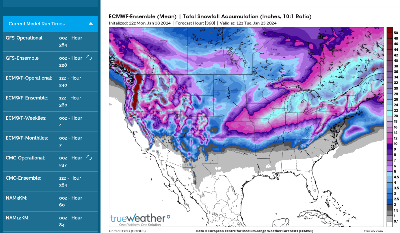
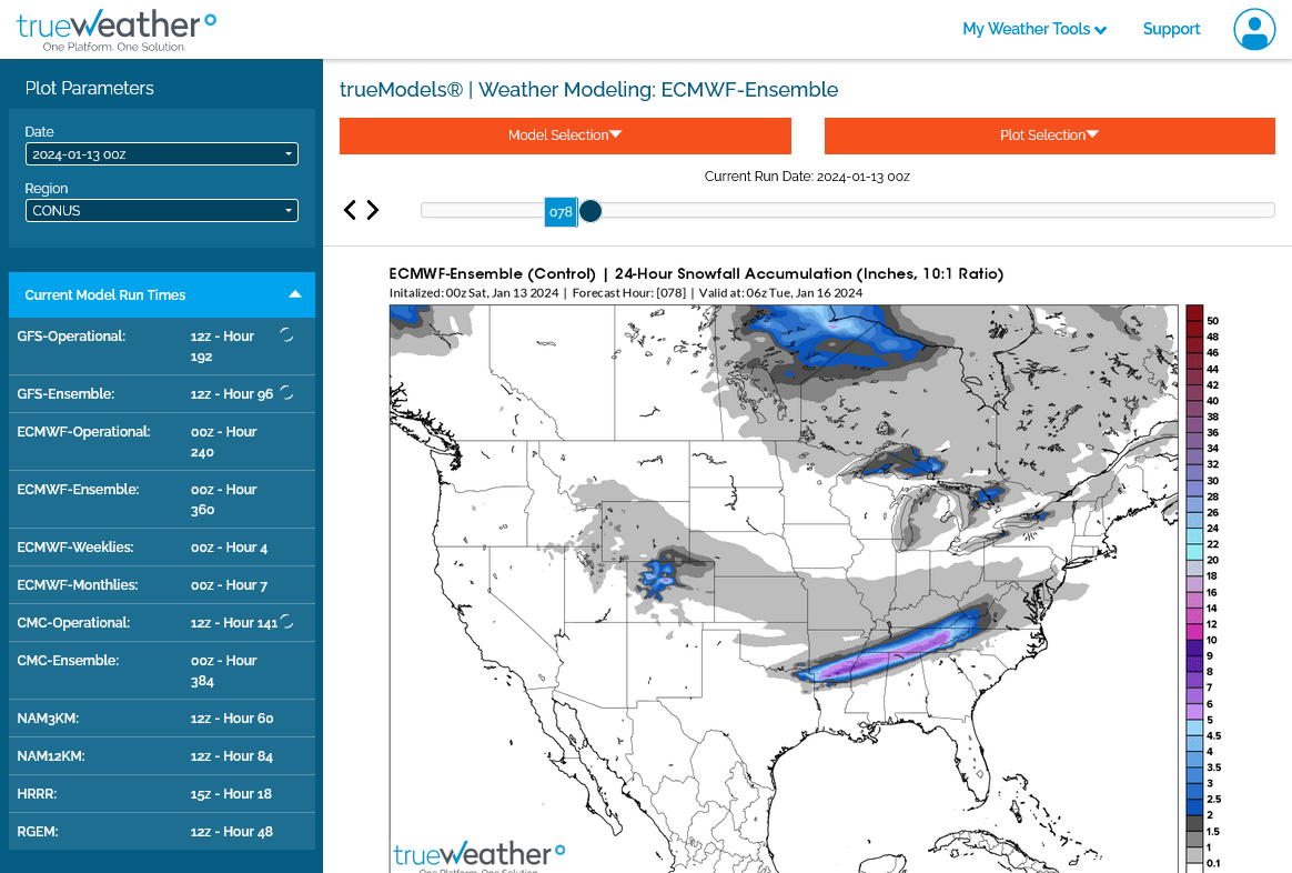
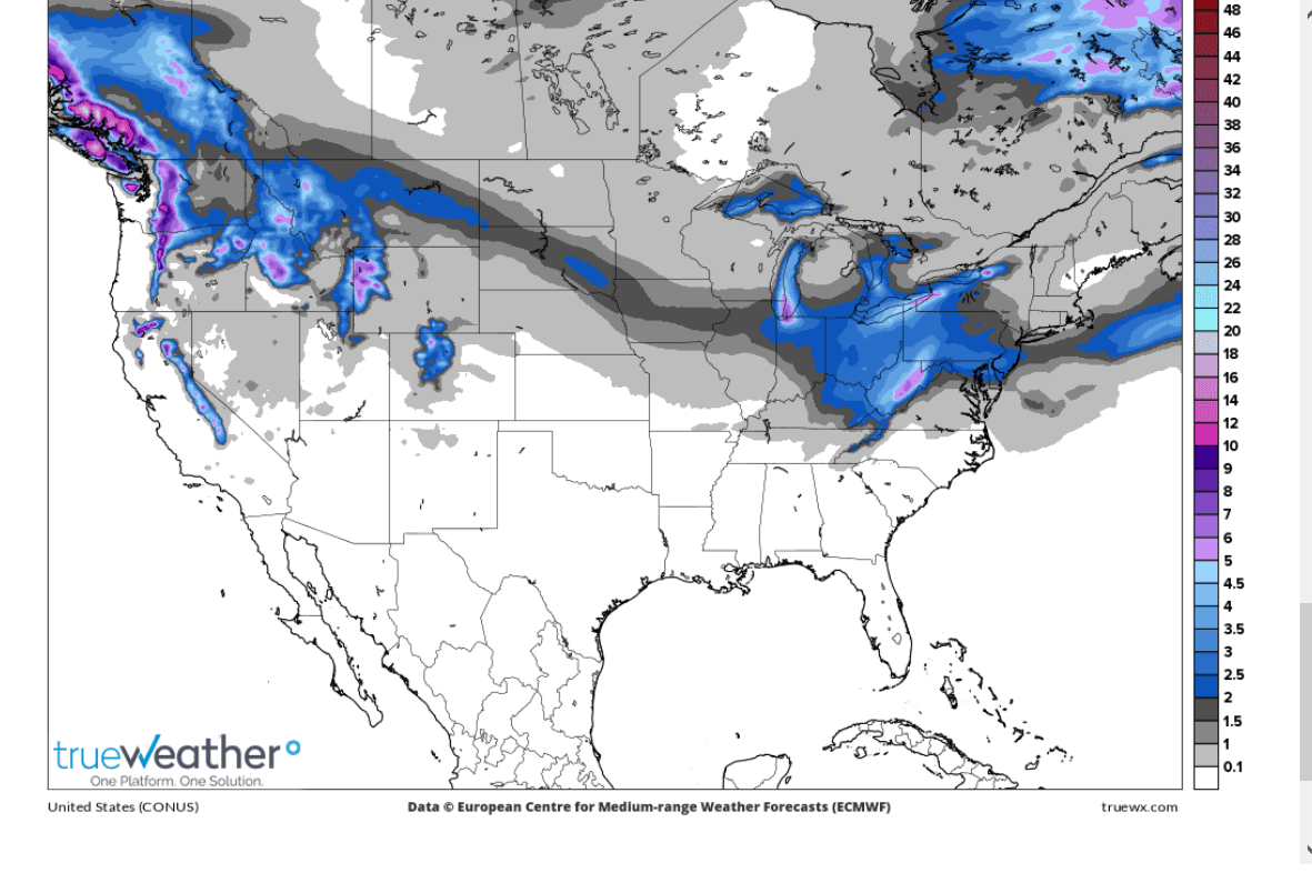
This is the total accumulated snow forecast for the next 2 weeks from the last 12z European model: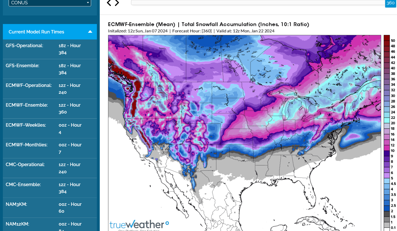
All the comprehensive weather:
https://www.marketforum.com/forum/topic/83844/
++++++++++++
Total snow the next 2 weeks from the last 12z European model:
Everyone crossing their fingers on the MLK Day storm
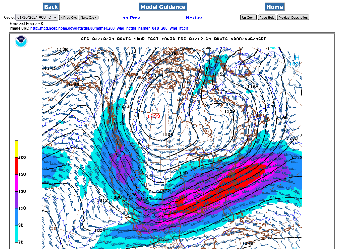
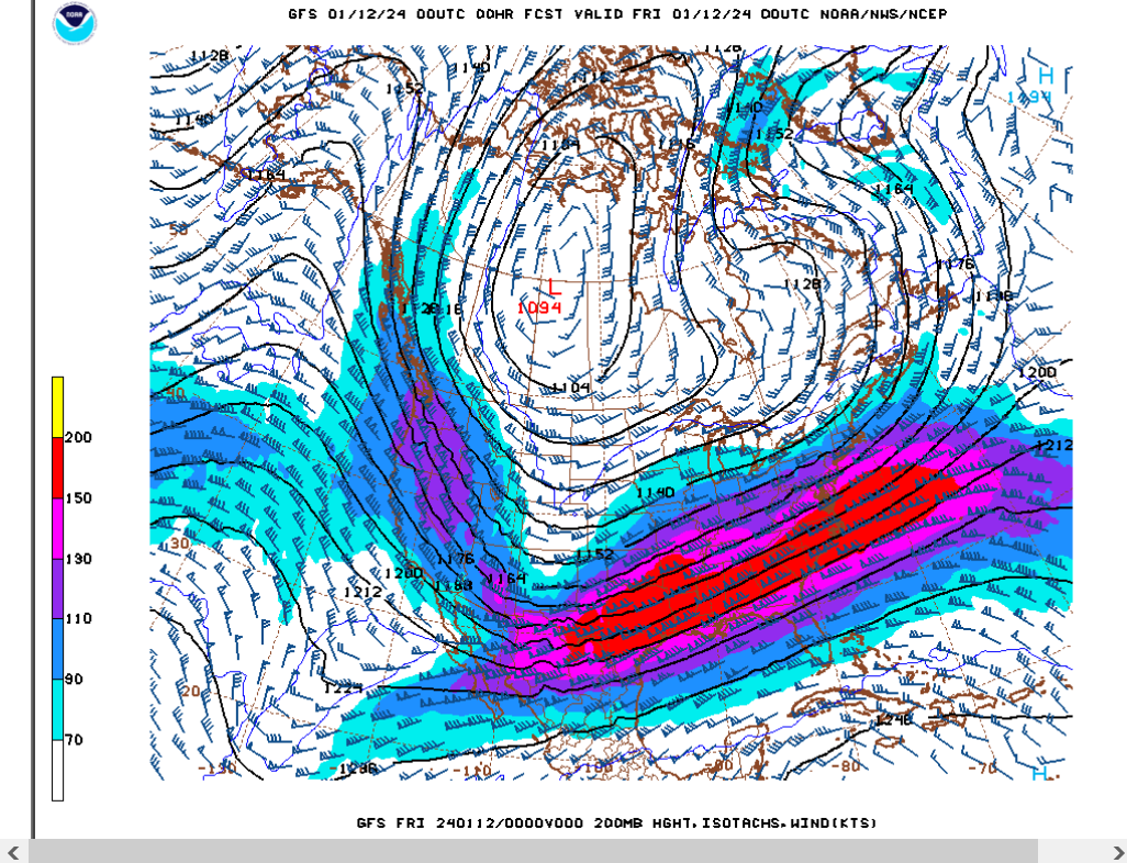
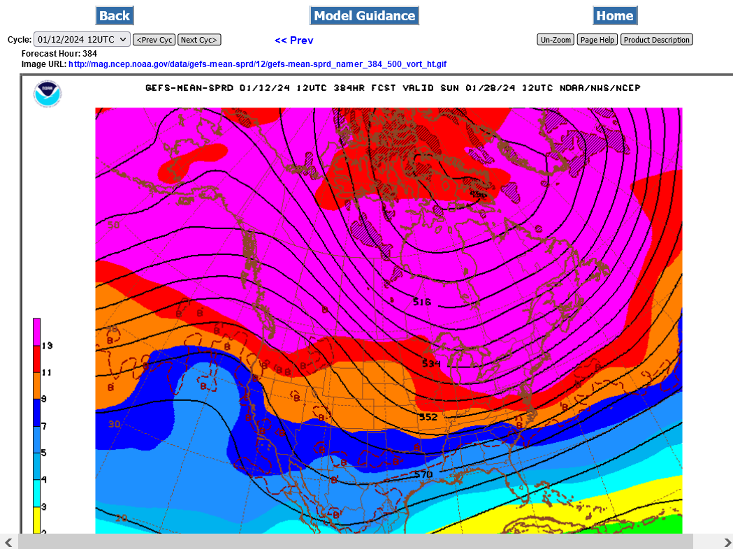
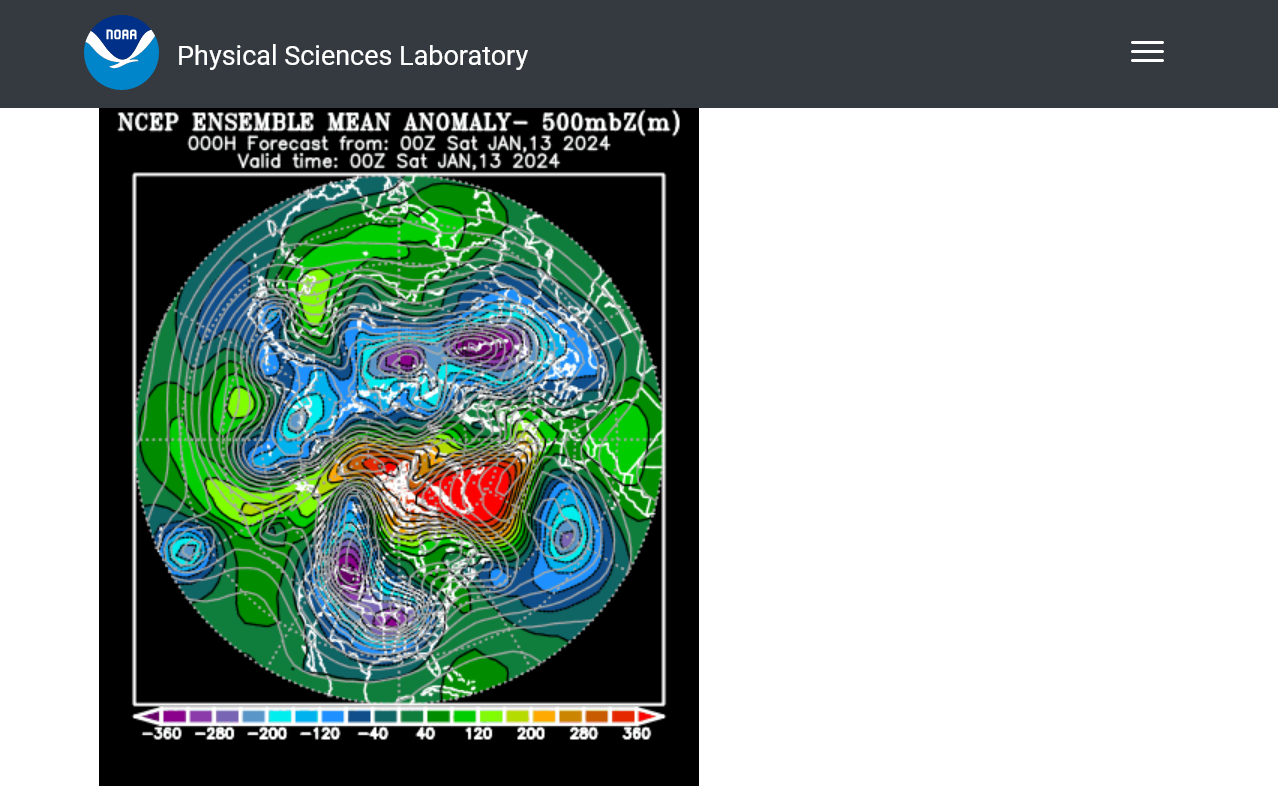
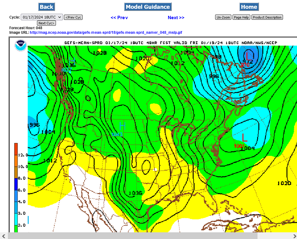
Check out the latest jet stream forecast for Thursday Night at 200 millibars, which is over 35,000 feet above the ground/almost 7 miles up!
The red shade is 150+ knots/hour or 180+ mph. The center of the red is likely roaring from southwest to northeastward above 200 mph.
That L around the northern Saskatchewan, Canada border is a polar vortex that's been greatly displace southward.
Winds on the back side are coming from Siberia, transporting frigid air across Canada and dumping it deeply into the United States.
++++++++++++++++++++++++++++
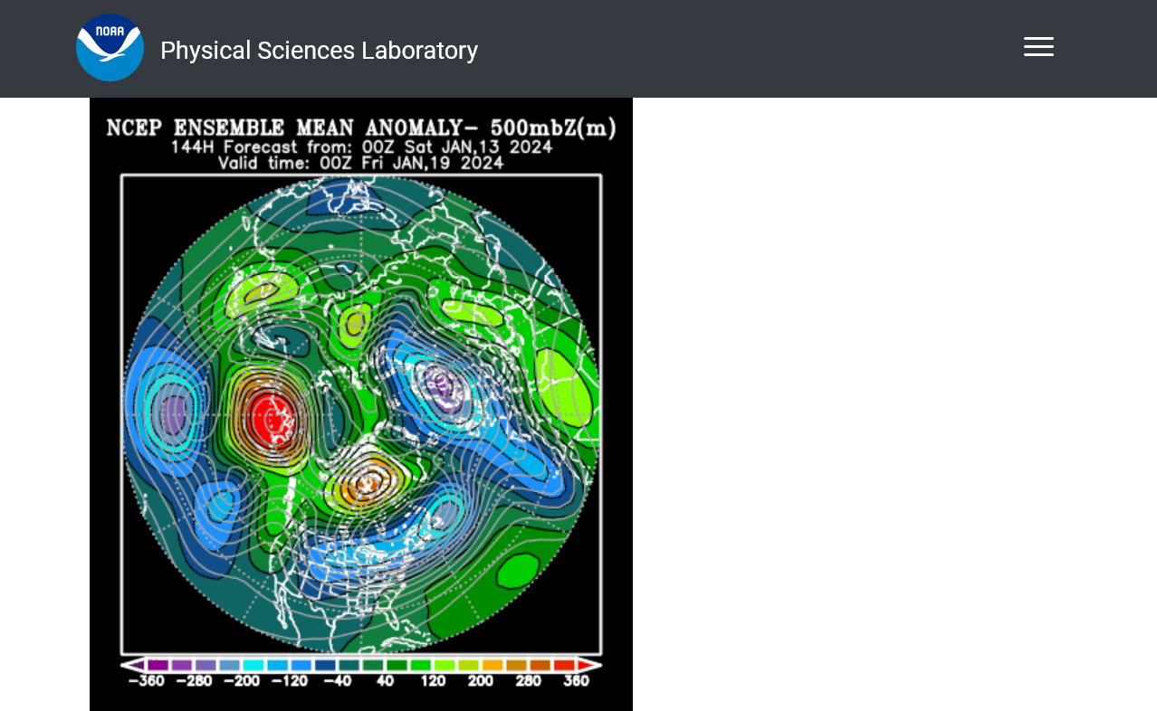
This is the look at 500 mb (15,000 feet/3 miles above the ground) later this week.
Note the extreme positive anomaly across northern Canada to Greenland and extreme negative anomaly in most of the U.S.
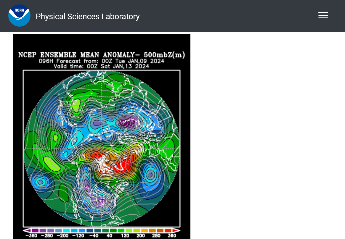
Here's Greenland:
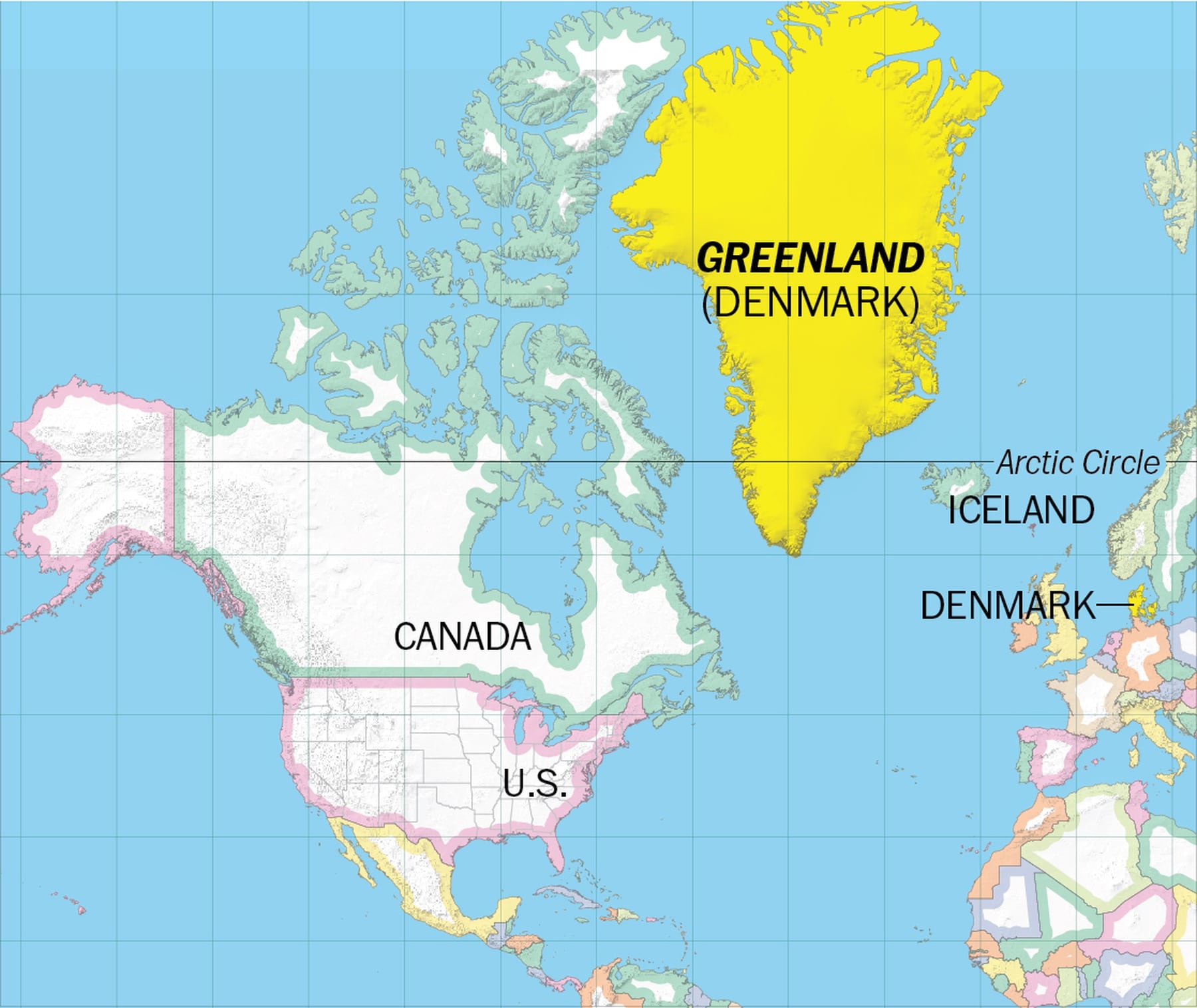
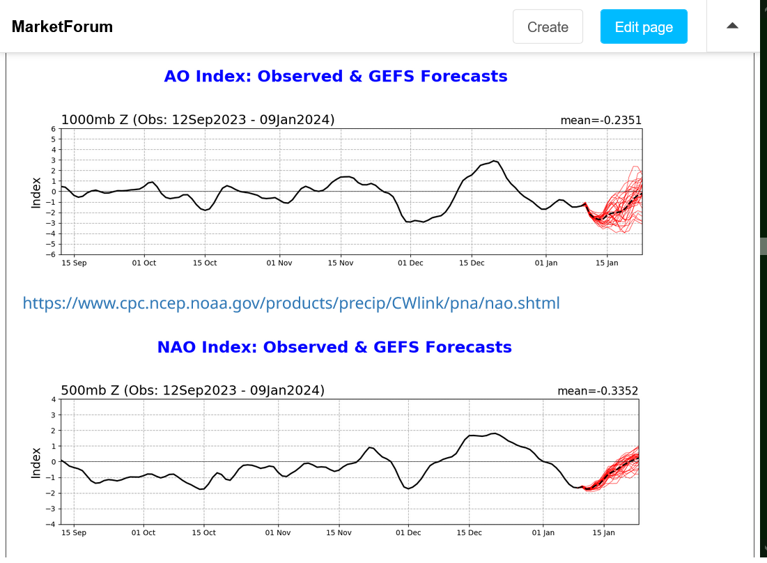
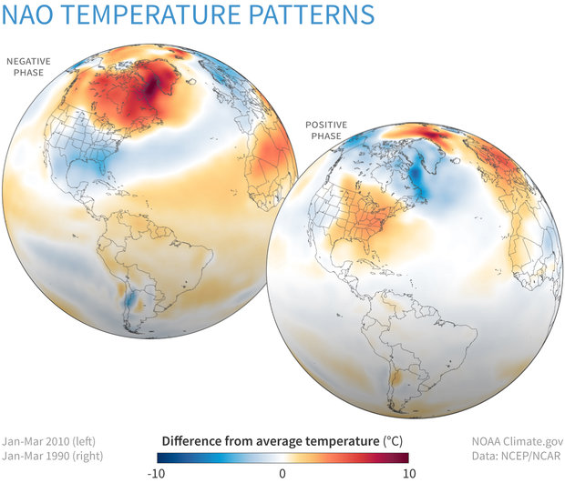
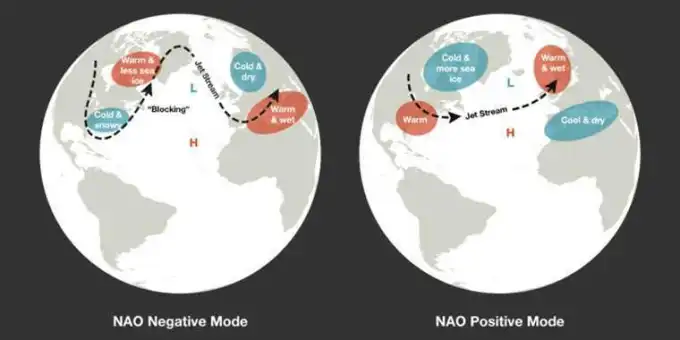
Both the AO and NAO are solidly negative!
https://www.marketforum.com/forum/topic/83844/#83856
https://www.trhava.com/2019/05/05/ao-nao-nedir/
AO(Arctic Oscillation):
http://la.climatologie.free.fr/ao/AO-english.htm
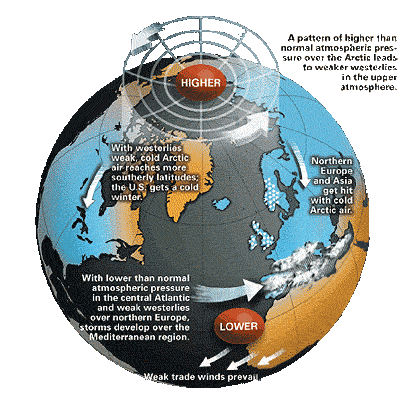
When the AO is negative phase then there is high pressures on the polar region and low pressures at the mid-latitude (approximately 45° North). The atmospheric pressure which is greater in the north pole decreases the strength of the West wind.
In winter the temperatures are higher than normal in Quebec, Greenland, North Africa and the Middle East, but lower in Europe and in the west of USA.
For those that were following us back in December, you may remember the discussion on the Sudden Stratospheric Warming (SSW) started by WxFollower:
Major Sudden Strat. Warming: chance increasing in early Jan
27 responses |
Started by WxFollower - Dec. 20, 2023, 9:19 p.m.
https://www.marketforum.com/forum/topic/101402/
++++++++++++
While we never had a SSW that resulted in a reversal of stratospheric winds from their usual west to east, we did have a huge slow down in the winds to near 0 that resulted in a slow down that caused the polar vortex to be disrupted and shift/reform unusually far south that was passed down from the stratosphere to the troposphere where our weather is.......resulting in the current pattern.
HERE COMES A MASSIVE WINDBAG STORM!!!
https://www.marketforum.com/forum/topic/101628/#101629
The pressure gradient with this one will be incredible. The main reason is related to this extremely powerful jet stream! The red shade is 150 knots/hour or 180 mph. The center of the red is 200 mph!!
I discussed/analyzed this earlier:
https://www.marketforum.com/forum/topic/101628/#101673
However, an additional element to a strong jet stream is that it LIFTS the air below in certain, favorable regions. Sort of like air is sucked into a vaccum cleaner, the air at lower levels is sucked up higher.
This causes less weight to the air below, which results in LOWERING pressures as a cyclone/storm develops.
That lower pressure compared to higher pressures surrounding it(pressure gradient) causes the wind to blow from high to low pressure.......but the earth is spinning(Coriolis force) which deflects the wind to the right and causes the wind to SPIN AROUND the low pressure, instead of immediately equalizing the pressure.
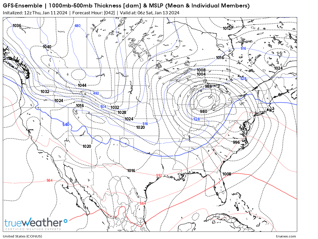
Friday Nights surface pattern, as a result will look something like this below.
Well below 980 mb LOW pressure in Michigan, with a very robust 1044 mb HIGH over Montana. The tightly packed isobars in between indicate the enormous magnitude of the pressure gradient...........and resulting HIGH winds that blow counterclockwise around the LOW.
Wind gusts could hit 60 mph just from the gradient. The threshold for a severe thunderstorm wind is 58+ mph. So there are high wind advisories and warnings in brown across many states right now.
Current Hazards at the link below.
Go to the link below, hit hazards box in the top right hand corner(it will also define all the color codes), if its not already in the hazards mode when you load the link.
Then you can hit any spot on the map, including where you live and it will go to that NWS with all the comprehensive local weather information for that/your county.
You can get the NWS products for your area, using the link above
At that link, just left click your mouse on the location you want to load information for.
+++++++++++++++++
For instance, this is the link for Evansville area NWS products:
There will also be a bit of severe weather on the warm side of this storm but not an outbreak. The air isn't warm/humid enough for that.
Severe Storm Risk......updated daily(days 1 and 2 twice daily).
https://www.spc.noaa.gov/products/outlook/
Current Day 1 Outlook |
You can see what's coming this weekend, on the back side of this system when very strong winds shift and blow the air mass currently to our northwest in.
We are near 50 right now in southwest Indiana. The wind chill will make it feel more than 60 degrees colder in just over a day!!!
+++++++++++++++
The "freeze frame" wind chill maps below start at 10am, then 2pm, then 7pm, then Midnight. You can really see the bitter cold on the move.
The last one is the latest.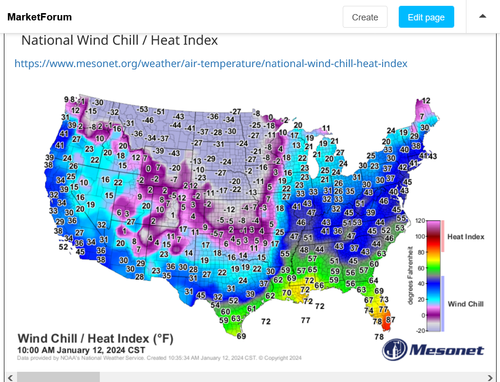
+++++++++++++++++
Below, we can see the very tight pressure gradient causing the powerful winds (gusting to 50 mph) which are driving this cold south and east:
https://www.spc.noaa.gov/exper/mesoanalysis/new/viewsector.php?sector=19&parm=pmsl#
Saturday 10am. WOW! -66 Deg. F Wind Chill in ND!!! Fortunately, the coldest air is being moderated as it pours southeast!
Look at how far southeast the cold has spread, 2 days later on Monday morning!
MetMike
You know me! Time to buy NG PUT!?
No response, so I bought Feb put. 208 pm cst
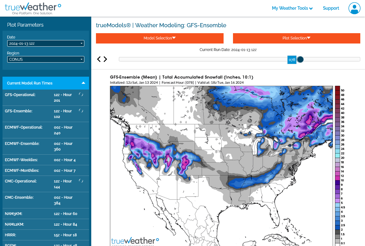
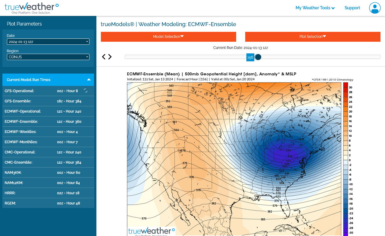
Sorry for not responding right away but I would say no at this point because this is what the upper level maps look like at the end of 2 weeks on the last 12z GEFS and the reason that we are sharply higher and at the highs but the weather can change, especially over a weekend.
Next storm stays south of Indiana.
1. Last 0z European model below
2. Last 12z GEFS(American model) below
https://weatherstreet.com/weather-forecast/indiana-snow-cover.htm
Snow totals the last 24 hours from this storm:
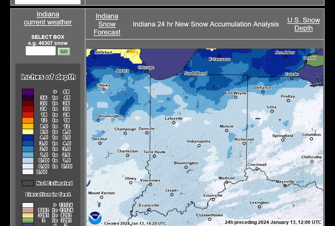
Snow on the ground.
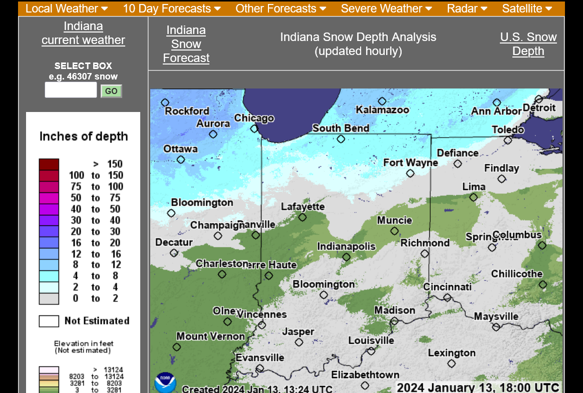
https://www.weatherstreet.com/local_forecast_files/Snow-Depth-US.htm
https://www.weather.gov/iwx/01122024_winterstorm
Our Scholastic Chess of Indiana, Individual Regional tournament in Warsaw was rescheduled for next Saturday because of extreme winds blowing the snow, creating challenges for travelers.
With no wind, people in northern Indiana don't have major issues with this amount of snow.
However, West winds gusting above 40 mph blow across north/south highways and drift snow, while making it impossible for road crews to keep up. In addition, a flash freeze caused moisture on roads to freeze up.
++++++++++++++++++
We will be in the grips of the dislodged Polar Vortex for the rest of this week........then temperature moderate quickly in the week 2 part of the current forecast.
The weather next Saturday is extremely important for the Warsaw regional. With that in mind, let's do an analysis of the current pattern and where it will be next Saturday.
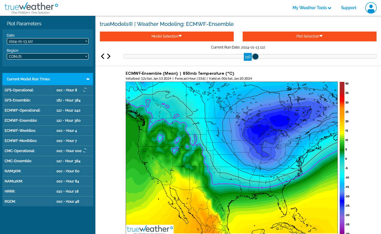
1. Upper levels right now(below). 2 pieces of the Polar Vortex that was disrupted earlier this month by the Sudden Stratospheric Warming event which caused stratospheric winds to slow down but not quite reverse. Note the negative anomalies below. The Polar Vortex is in the United States right now. That doesn't happen very often. An extreme positive anomaly is centered from Central Canada to Greenland....closer to where the Polar Vortex normally resides!!
https://www.marketforum.com/forum/topic/101402/
This greatly weakened the strong westerly jet stream winds which keep the Polar Vortex trapped in the high latitudes. As a result, the Polar Vortex has reformed/shifted many thousands of miles south of its usual position.
https://www.psl.noaa.gov/map/images/ens/z500anom_nh_alltimes.html
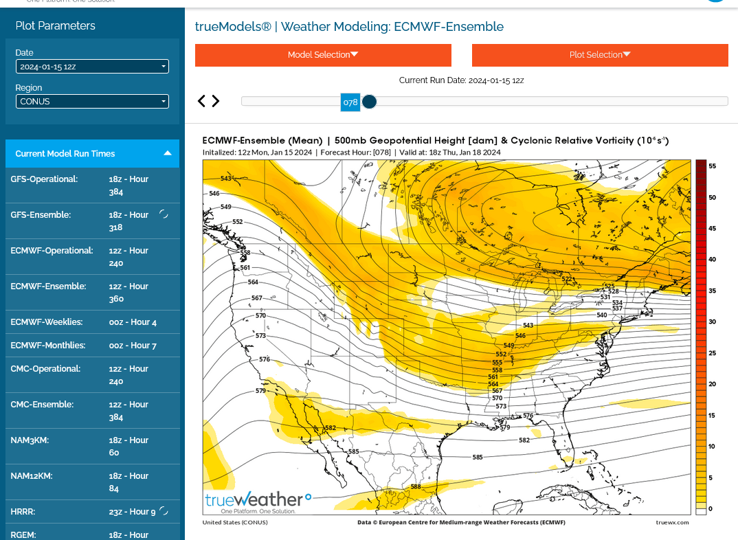
2. Upper levels late this week(below). The Polar vortex has weakened and shifted east quickly.
3. The European model shows whats left of the departing Polar Vortex on Friday Night to still be VERY impressive in the eastern parts of the country. Cyclonic flow and extremely cold air aloft means the potential for snow showers on Saturday as far west as the Great Lakes down to the Southeast.
4. 850mb temps(1 mile above the ground) next Friday Night (below) show bitter cold! Temps will struggle to get out of the single digits during the day Saturday, in northern Indiana, after the last reinforcing blast of Arctic cold hits.
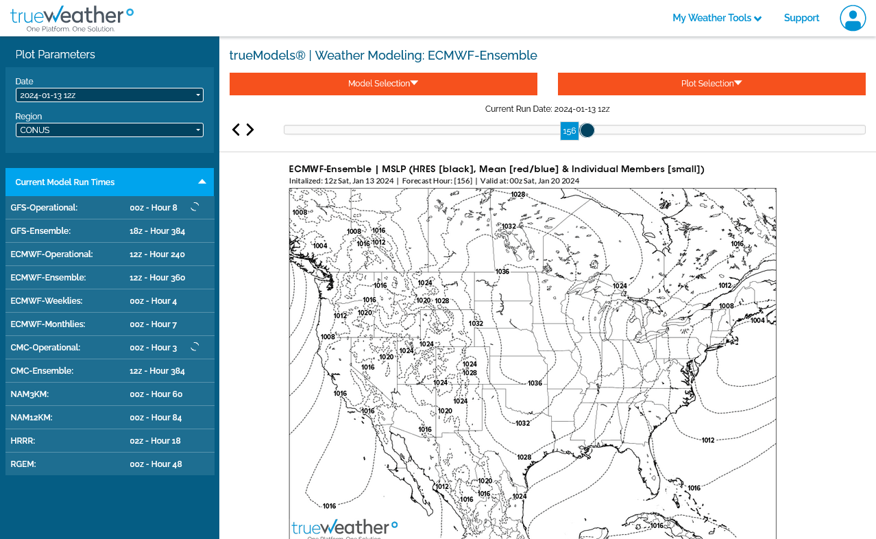
5. Surface map next Friday night below shows the threat of a big Winter Storm along the East Coast with a very tight pressure gradient as a result of the contrast with a strong Arctic High to our west(the last one for this pattern). This will create stiff winds and a well below 0 Wind Chill factor next Saturday with snow showers possible. Heavier snows will likely be confined to the Northeast U.S. and Lake effect.
Not much threat for an organized storm/low like this last one with heavy snows. However, an upper level perturbation and surface trough/last reinforcing cold front can potentially cause a couple of inches of very light, fluffy snow with snow to water ratio's in the bitter cold air being more like 40 to 1 compared to a typical 10 to 1 ratio. .05 worth of precipitable water that makes 1/2 inch of snow at 30 degrees will make 2 inches of snow at 10 degrees(4 times as much fluffy snow). I'm not forecasting 2 inches of snow, just saying that it won't take much to generate 2 fluffy inches in bitter cold air.
https://opensnow.com/news/post/snow-ratios-explained
https://www.eldoradoweather.com/current/misc/snow-to-water.html
Conversion of Snowfall to Water Equivalent
National Weather Service forecast for Warsaw. Watching for next Friday/Saturday
++++++++++++++++++++
National Weather service for Evansville. Winter Storm tracks south of us Sunday Night/Monday.
Great Call tjc! Glad you didn't wait to hear from me (-:
Huge moderation in week 2 with above average temperatures but threatening to turn very cold again in week 3. NG in storage is at a record level for mid January, which reduces the upside potential but I wouldn't want to be short if we turn cold again in the high population centers of the Midwest/East/South.
Despite the $2,000/contract lower open, we're still within the trading range of Friday, although we spiked lower than that in the first couple of minutes.
We can move this discussion to the natural gas trading thread, please.
Tracking the southeast movement of this cold from the Polar Vortex the past 3 days:
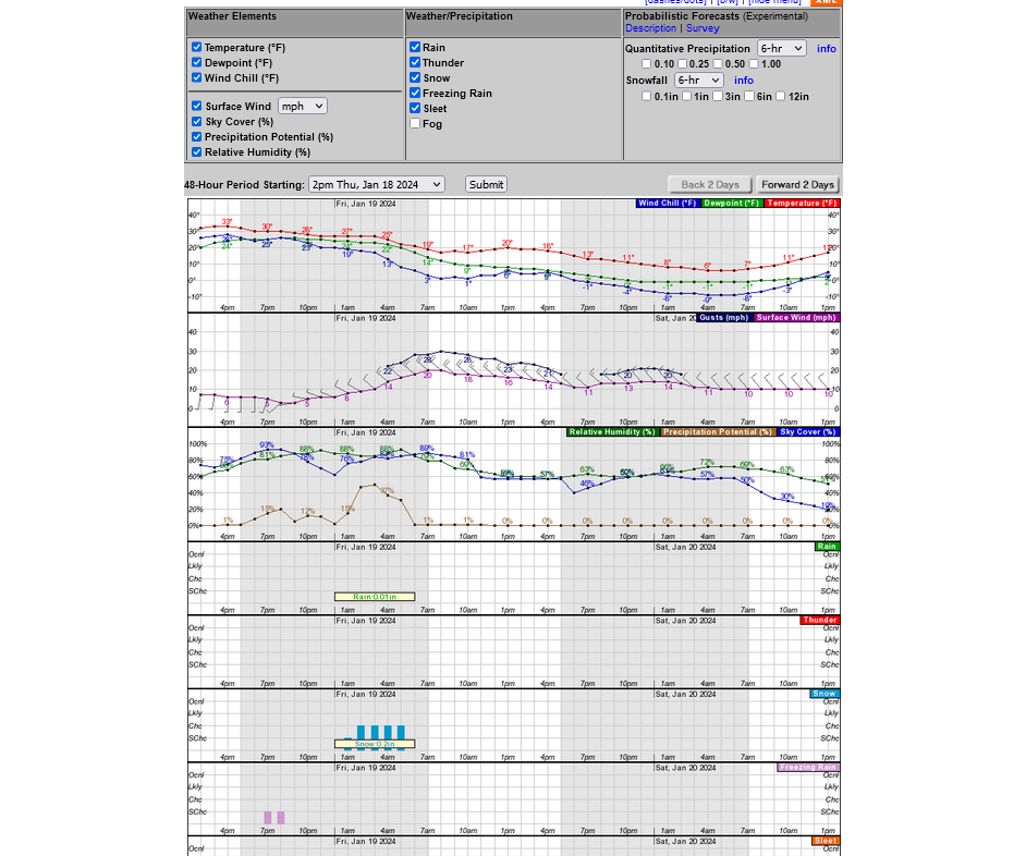
Forecast for Warsaw on Fri/Sat.
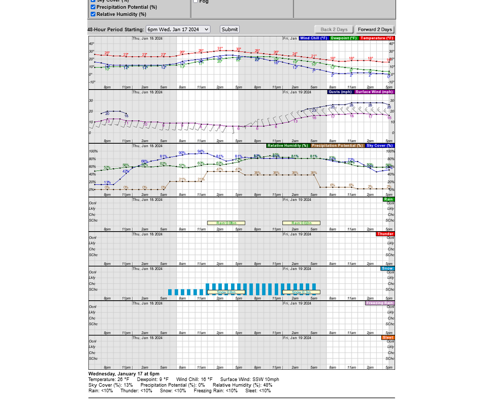
Another reinforcing blast of Arctic air on Friday with winds gusting to 25 mph(half the top speeds of a week earlier). This will be very fluffy snow in the cold air that will really blow easily but hopefully just 2 inches.
Most of the snow should end Friday Night. Winds will still be fairly strong very early Saturday but diminish.
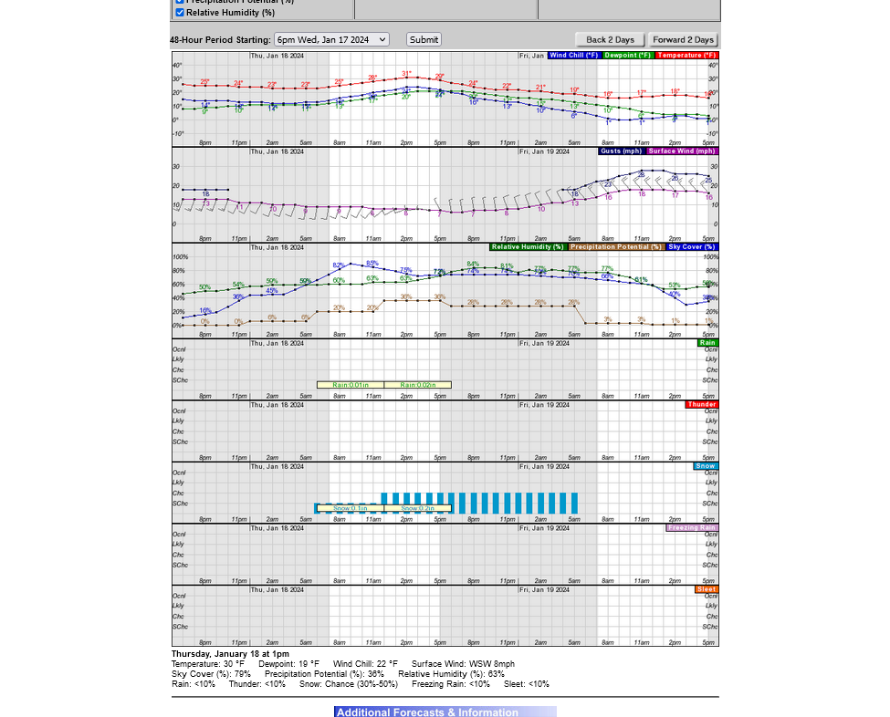
Evansville's snow threat this week will be elevated on Thursday into early Friday.
Potential for 1+ inch of snow from a couple of upper level perturbations rotating cyclonically around the base of the departing polar vortex, which will be in Southeast Canada at that time. This is Thursday's 500 mb midday map from the last, 12z European model below.
The latest forecast for the Warsaw Regional on Saturday is not looking so great on Friday.
Have high confidence in the COLD and WIND and SNOW but amounts are tricky with this dry and cold but unstable(aloft) air.
I'll guess around 2 inches. No major organized storm like a week earlier and the snow will be fluffy(blown around like crazy ON FRIDAY) with winds half those of a week earlier.
For Evansville, the forecast is continued threatening for potential school closings on Thursday/Friday.
Snow chances are elevated on Thursday thru early Friday morning. First guess is 1-2 inches. Winds don't really pick up until very early Friday, near the end of the snow event but that will likely cause BLOWING SNOW that already fell during the day on Friday because winds will be gusting to 30 mph. Not as windy as a week ago but the last few hours of the snow, early on Friday will probably be fairly fluffy and easy to blow around.
The winds early Friday pick up abruptly BEHIND the Arctic blast/cold front.
Like with Warsaw, above, the COLD, WIND(on Friday) and SOME SNOW(Thursday/early Friday) are extremely likely. Amounts are less certain. Without an organized surface low (there WILL be a strong cold front with 100% certainty) amounts won't be heavy.
Snow amounts that were light to begin with have been reduced even more on recent model runs!
More details later today.
Weather advisory for Thu and Fri morning for every county south and east of Evansville. More in an hour.
Sorry it was a bit longer. No big changes except that we're close enough to this tricky event so that we can fine tune the forecast to identify the highest risk areas.
The precip will be extremely light. However warmer air returning aloft is going to cause temps in the clouds to be ABOVE freezing in much of Western KY. So very light freezing rain/drizzle is actually the highest risk for roads.
The feature setting this up is the long lived frigid air mass parked on top of us this week. The ground is deeply frozen and many roads, especially untreated side streets will immediately become slick with even a tiny amount of light rain/drizzle that freezes on contact.
Evansville is on the edge of:
1. The purple area has barely enough amount moisture/convergence for some of it to get squeezed out.
2. There's an area aloft that is warm enough, barely above the 32 degree freezing point for it to be fall as liquid. Moisture that gets far enough north, could fall as extremely light snow or tiny sleet pellets if it freezes on the way down. This is MUCH better than if it freezes after hitting the surface.
3. There is no way the NWS or anybody can generate a map, similar to the one below to exactly depict any event like this. We have wonderful and greatly improved technology and forecasting and they are good at what they do.... but we can assume there will be a margin of error of something like 30 miles at the edge of the purple.
They may have already taken that into account and been a bit generous with the northwest extent of the purple area. However, it's not likely that Henderson, just south of the Ohio River will have serious travel problems and suddenly after you cross the bridge, roads will be perfect.
The farther southeast we go, the higher the risk. Farther northwest..........lower the risk.
Check the forecast late tonight and early Thursday as there likely will be adjustments.
Schools in all of Western Ky are closed tomorrow. Maybe the ones in IN that are in purple.
I'm thinking that Friday could actually be a higher threat for school closings in the areas Not shaded in purple. Very light snow overnight Thursday with MAJOR blowing Friday morning. Side streets are going to have slick spots and be dangerous for buses to drive on. Not for sure but at least a 50% chance.
Sorry for ignoring the more important Warsaw forecast. I really wish it was better.
I will guess around 3 inches of snow that's easy to blow from its light consistency. However, the numerical models have abruptly dropped the wind forecast, which I'm skeptical of because of the widespread tight pressure gradient below.
Not sure what the numerical guidance is thinking but its a good sign for them to have LESS wind than before. I still think winds will gust above 20 mph on Friday, everywhere in Indiana which will cause some blowing and drifting of the light weight snow.
The snow will end very early Saturday with winds rapidly diminished so Saturday will just be cold and a great day for chess if the schools don't shut it down on Friday.
Friday midday surface map/gradient below. Strong gusty winds blowing any snow that falls around. Even 1/2 inch in Evansville Thursday Night/early Friday may be too much with this wind.
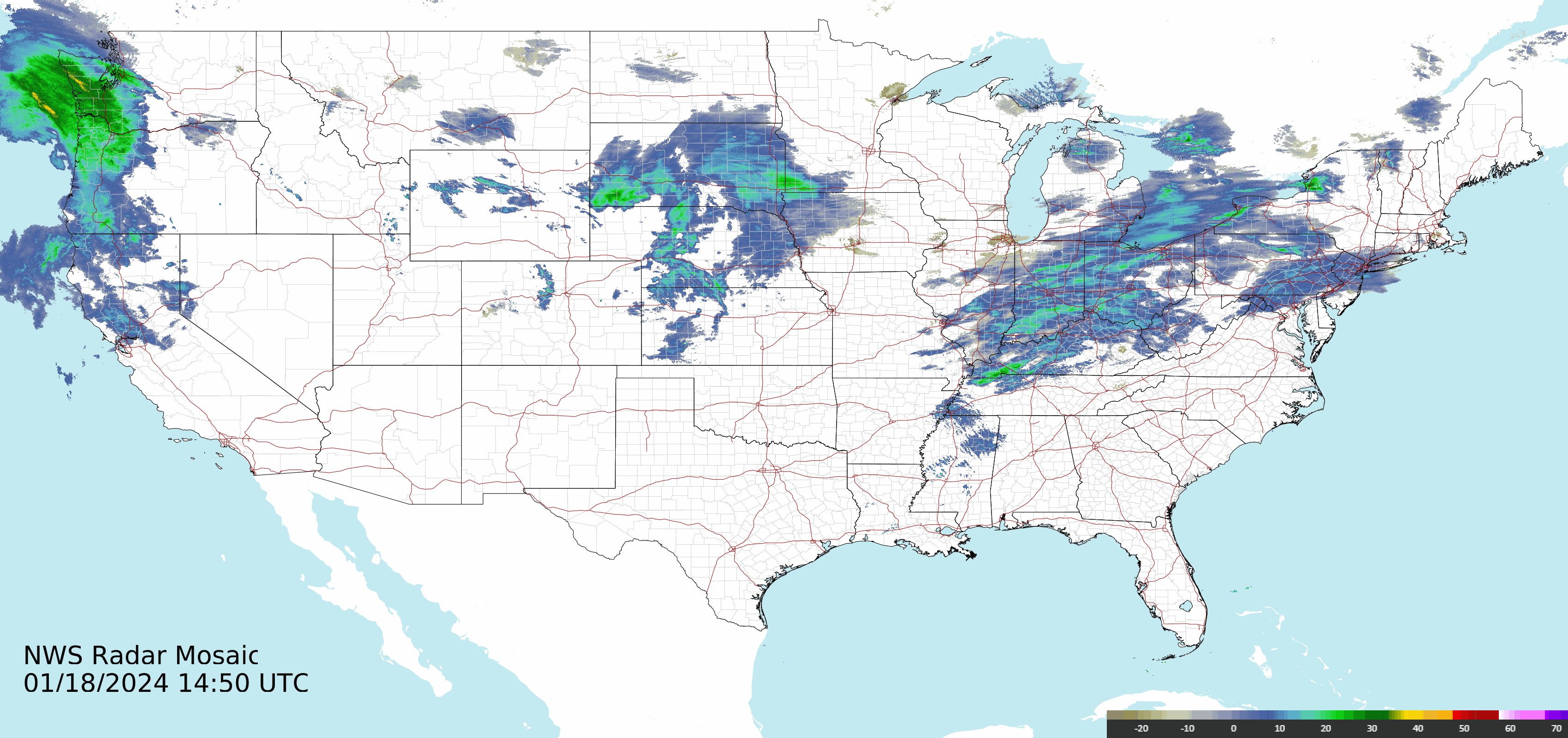
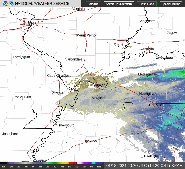
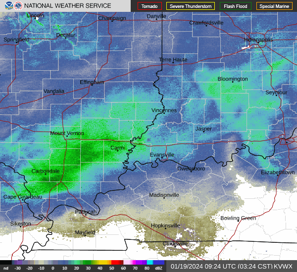
If one used just the radar returns, we would think there is very light precipitation falling in areas of Indiana where nothing is falling.
What's happening in this extraordinarily dry air is that it's subliming on the way down.
10am radar image below
https://www.eldoradoweather.com/radar/national-doppler-radar-full-resolution.html
https://thermastor.com/dew-point-and-weather-maps/

Current conditions at
Evansville, Evansville Regional Airport (KEVV)
Lat: 38.04°NLon: 87.52°WElev: 417ft. Temperature: 28°F -2°C
| Humidity | 49% |
| Wind Speed | S 7 mph |
| Barometer | 30.07 in (1018.9 mb) |
| Dewpoint | 11°F (-12°C) |
| Visibility | 10.00 mi |
| Wind Chill | 21°F (-6°C) |
| Last update | 18 Jan 8:54 am CST |
There's a big 17 Deg. F spread between the temperature, at 28 F and the dewpoint at 11 F. That gap needs to close for the air to become nearly saturated and the humidity to approach 100% for anything falling to not be absorbed into the very dry air on the way down.
10am radar image below
Almost Live, updated radar image below 
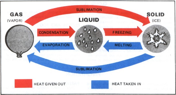
Sublimation is when frozen water/snow converts directly to a gas/vapor, bypassing the liquid state.
It happens only when the temperature is BELOW FREEZING and is greatest when the air is VERY DRY.
The snow that fell on Sunday Night has been subliming for the ground all week in the sub freezing temperatures.
https://www.aviationweather.ws/027_Change_of_State.php
The outlook for Warsaw is unchanged )-:
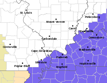
Pink below is a Winter Storm warning, surrounded by a Winter Storm Watch. Those areas will see snow amounts enhanced by downwind Lake effect.
Purple is a weather advisory. The NWS links have sometimes not worked well this week. Maybe they're getting overloaded.
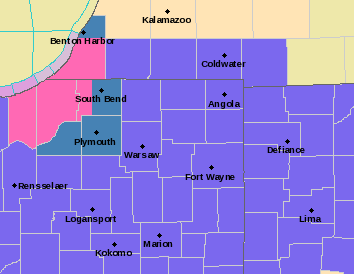
This map below is the total snowfall forecast between now and Saturday morning from the last 0z European model overnight. Warsaw is located close to the 3 inch band. Basically on the edge/periphery of the lake enhanced snow.
++++++++++++
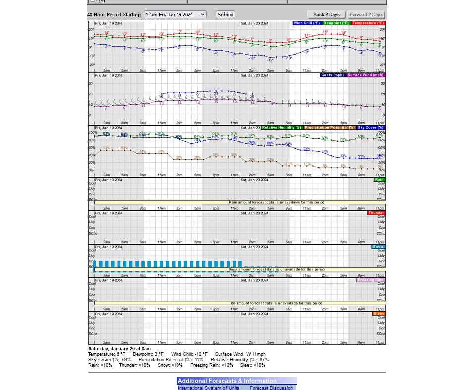
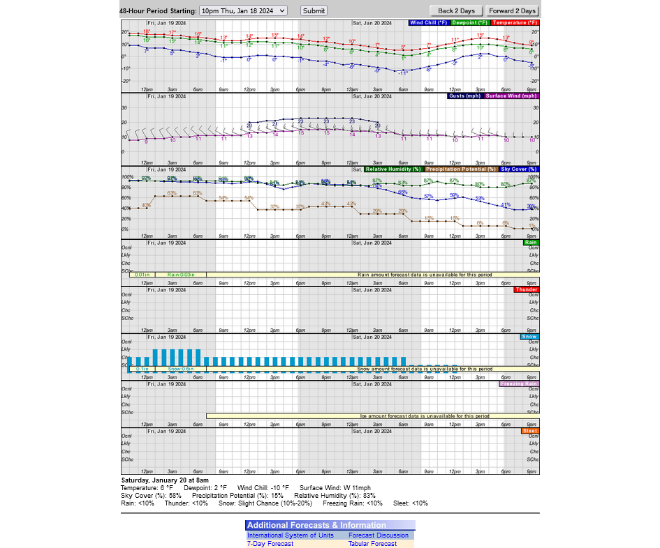
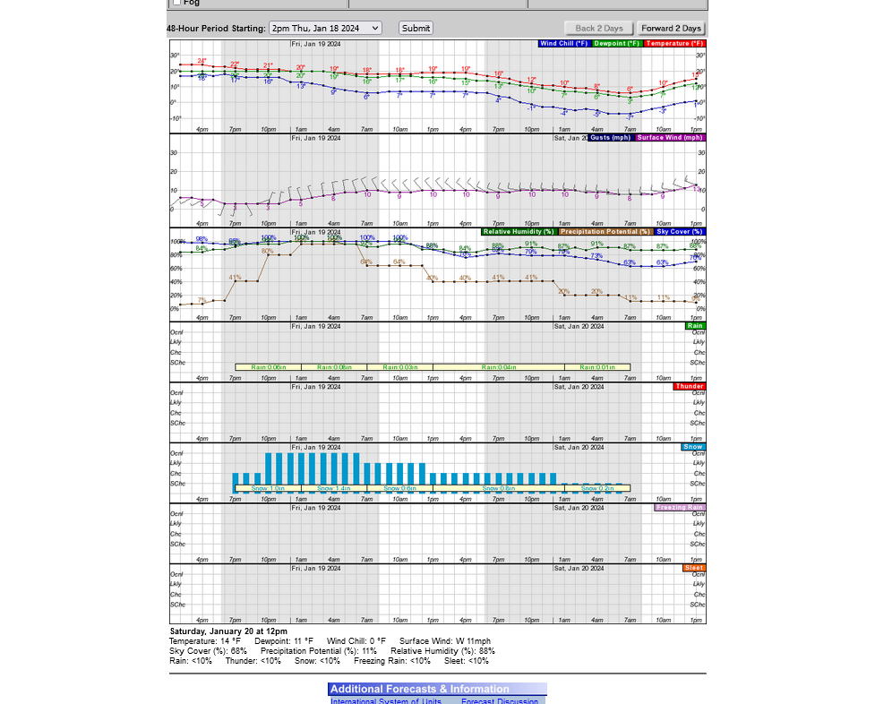
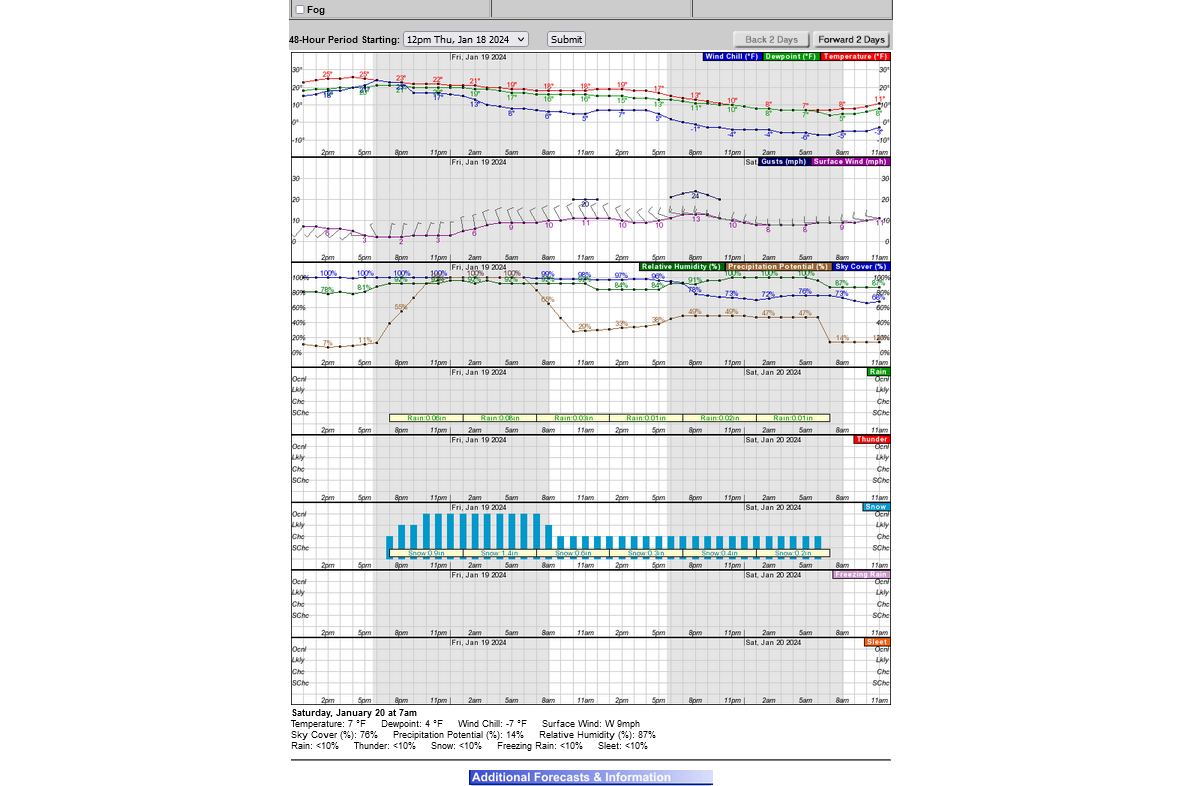
This is the last computer generated weather graph for Warsaw the next 24 hours. I mentioned being skeptical yesterday that this product dropped the wind forecast way down. It was a fluke. Wind gusts are forecast back close 25 mph on Friday. That's still less than half the wind from last weeks storm and a bit less(but fluffier, easier to blow) snow.
The KY portion of the forecast was a complete bust with ZERO precipitation everywhere.
The latest weather graph for Evansville below.
Very light snow amounts overnight than very strong winds.
I think that there will be school on Friday but the EVSC will have somebody up REAL early to check road and weather conditions to make a call Friday morning NOT Thursday Night.
Will Evansville, IN dodge another Winter weather bullet eaerly on Friday?
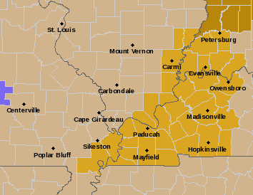
Look at all those weather advisories for tonight/Friday.
To our west, east north and south.
In fact, there is only an extremely narrow strip of white in southern Indiana that includes a handful of counties and Evansville.
This is surrounded by hundreds of counties in every direction with purple for snow(pink heavy) and blue for extreme cold.
Will our dinky island somehow avoid the Winter weather that everybody within 500 miles is going to experience the next 24 hours? Is there a weather force field deflected it away (-:
1. We WILL absolutely be impacted by the brutal cold and winds on Friday. Winds gusting to 30 mph will cause the Wind Chill to drop to 0 early in the morning and when the kids will be outside waiting their bus. Same exact condition all day including leaving school, though there isn't a wait outside. They are look at this as just above advisory criteria.
2. Snow showers, mainly increasing from 3am and lasting to, maybe 7am will be whipped around by those winds and could make for some slick roads, even if only 1/2 inch falls. The NWS is looking at this as being just below Winter weather criteria.
When the EVSC assesses the situation on Friday morning, if we do get that much snow, they may decide to cancel school. I'll say 75%+ chance of cancelling school on Friday for the EVSC. Having a 2 hour delay is a complete waste of time.
Temperatures will NOT be increasing.
Winds will NOT be diminishing.
Roads will NOT be improving.
It will just mess up peoples routine/schedule to accomplish nothing.
They should either cancel school or have a full day.
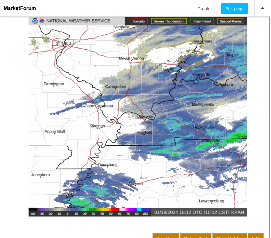
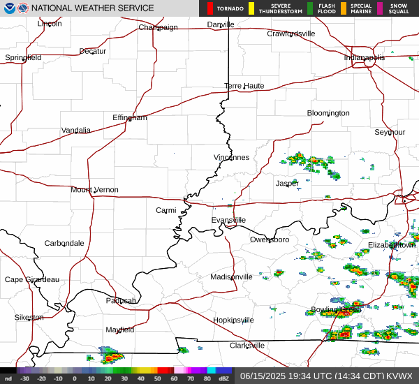
This is a better radar image that shows the main snow area.
|
10pm update:
Some extremely light snow is already reaching the ground and covering the pavement outside. I'll say 85%+ of no school tomorrow.
Note the darker greens in Central Illinois associated with the cold front. Most of the heavier snow with that could pass north of us but 1/2 inch is likely.
It looks like this first wave of snow will diminish before midnight, then a heavier wave could hit after 3am.
This was the 11pm frozen frame radar below.
The dew point, which started the day at a bone dry 7 Deg. F has been increasing and is now up to 24 Deg. F. With the layers above the surface also moistening up, the snow is making it down to the ground.
The temperature is 29 Deg. so the spread between the air temp and dp temp is only 5 degrees. This morning, the spread was as great as 20 degrees. If we had that same big spread right now, none of this snow would be surviving on its fall to the surface.
The time stamps on these posts are in EASTERN Standard Time, 1 hour ahead of us!
So this post was started at 3:31 am CENTRAL Standard Time because it shows 4:31 am.
The maps below were not frozen so they are being constantly updated Despite comments that were based on the earlier times frame.
+++++++++++++++++
You can see what's coming with the current observations around the lower Midwest.
1 item that has changed is that Warsaw has dropped the magnitude of their winds in the latest forecasts which will mean much less blowing snow. The tightest part of the pressure gradient is farther south, so that makes sense.
Warsaw is no longer ending the snow early Saturday, instead snow showers continuing on Saturday which is not going to be anything but a nuisance if they can have the school open (the frigid temps and wind chill below 0 on Saturday may be a bigger nuisance than the light snow accumulations).
For Evansville, it appears that all the 3am/latest reporting stations behind this cold front in central IL are reporting light snow, so there will likely be several hours with those conditions and we've already coated the ground with a couple tenths of an inch.........winds will be picking up a great deal shortly.
I will be pretty surprised if the Evansville schools don't cancel shortly.
LOWER MIDWEST
https://www.spc.noaa.gov/exper/mesoanalysis/new/viewsector.php?sector=20
https://www.spc.noaa.gov/exper/mesoanalysis/new/viewsector.php?sector=20#
https://www.spc.noaa.gov/exper/mesoanalysis/new/viewsector.php?sector=20#
The temp in Evansville is 28 and DP is 25, so the air is close to being saturated and the snow can survive its trip down without being eroded by dry air.
The purple lines above are isotherms(temperatures) look how tightly packed they are behind the cold front in the colder air that will be driven down today. We'll likely see temperatures FALLING during the day, into the teens.
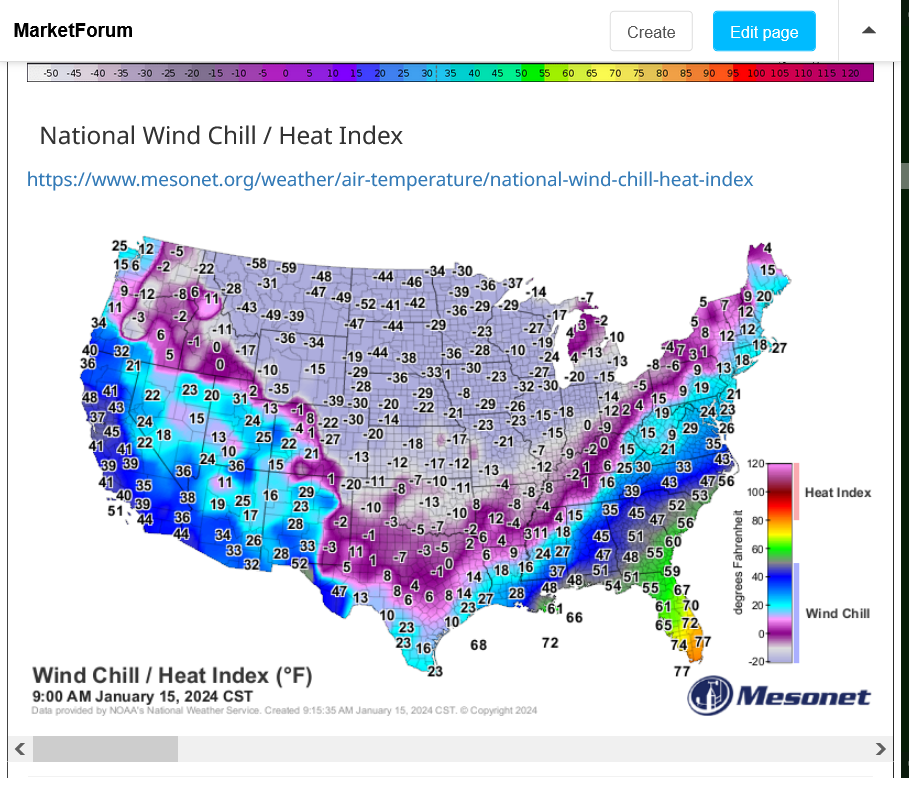
Note the frigid Wind Chill temps below in that air mass coming in which will be the LAST BLAST this month. Temps will bounce back to above normal next week!
National Wind Chill / Heat Index
https://www.mesonet.org/weather/air-temperature/national-wind-chill-heat-index
The radar shows a heavier band of snow has developed that's coming in just ahead of the cold front(from the convergence and lift)..........exactly in the spot where there are no advisories for snow!!! This will pick up the intensity of snow for up to an hour in Evansville!!
Maybe close to an inch of snow during that time and plenty enough to make all the side streets snow covered and slippery for buses in the morning.
C'mon EVSC, cancel school and get it over with!!!!
I'm not on their email list, so I won't get the word immediately.
3:24 to 3:42 am images below with heavier snow band about to hit.
Below that is the latest radar looping images.
The cold front just came thru at our house at just after 4:19 am. Winds immediately picked up. Going from Westerly at around 9 mph(before hand) to NW at ~15 mph with gusts to 25+ mph behind the front and will remain at that higher magnitude the rest of the day.
99.9% chance of no school today!
+++++++
The 5am wind at the NWS was gusting to 29 mph!
Looks like we got an inch of snow that will be getting whipped around by these strong gusty winds.
The EVSC cancelled school as expected.
reminder that the time stamp on these posts are Eastern time, so subtract an hour for Evansville times.
The local TV anchor stated snow amounts were 1/2 to 3/4 of an inch in Evansville from this event.
Not that its a big deal but the heavier snow band that came in just before 4am contributed to most of our 1 inch of snow, here exactly 3.5 miles due north of the Evansville airport.
https://www.marketforum.com/forum/topic/101628/#101793
There was also a band of much lighter but unexpected snow before midnight, along the southern tier of counties in Indiana:
https://www.marketforum.com/forum/topic/101628/#101789
+++++++
The main reason to bring this up in retrospect is that area was exactly the area with no weather advisories and expected to get the LEAST amount of snow from this event(more expected south on Thursday-more expected north early Friday).
1 inch of light snow is a tiny amount of moisture to get squeezed out of the clouds. The airport measured .02 liquid by I think it was a bit more(for sure at our house!).
However, that tiny amount created very slick and dangerous driving early Friday!
I grew up in Detroit in the 60's and 70's and didn't have a snow day until Monday, December 2,1974, while a freshman at the University of Detroit, when almost 19 inches of snow fell that Sunday/Monday after Thanksgiving.
Evansville has more snow days in the average year, then what I saw, total from grades K-12 which was 0.
Forecasting huge storms like that, even back then could be done several days ahead of time(but even better today).
Imagine trying to forecast .02 worth of moisture that fell on Evansville overnight Thursday?
One of those........maybe it will or.......maybe it won't scenario's until its almost happening.
But people, understandably want to know early in the week:
Will there be school on Thursday or Friday?
We're just making educated guesses for a tricky event like this. There could be 10 more just like it and half of them might produce even less with school, the other half no school.
More interesting is Evansville's historical Winter weather history, because.........that's where we live!
I'm sure everybody living here at the time remembers the recent ones:
The snowstorms of 1917-18 weren’t the biggest news in the city thanks to, you know, World War I. But that winter dumped 67 inches of snow on Evansville – 41 in January alone.
++++++++++++
Can you imagine 67 inches of snow in 1 Winter???
Lots of stories about this blizzard in January. Brad Byrd was on the air at a different station then WTVW ( I worked with him as the chief meteorologist from 1982-93 at his current station, WEHT).
This same storm shut down the University of Michigan for the first time in its history. Streaking was a big thing back then and I went streaking around our all mens dorm, doing several laps wearing only snow boots, with everybody cheering thru their open windows. More each time as they heard the commodition and we were all snowed in.
Between 14 and 24 inches of snow buried Evansville just before Christmas that year.
++++++++++
I measured 24 inches from 2 different waves, spaced around 12 hours apart. We drive to Detroit for a week every December 26th and dodged that one. Came back and most of the snow had melted.
Horrible. Miserable. Hellish.
All those words could describe the 2009 ice storm – as well as a few others my editors won’t let me print.
Five inches of snow fell in late January that year, but that was nothing compared to 1.25 inches of ice that encased power lines and turned the streets into post-apocalyptic hockey rinks.
+++++++++++
I remember going out in the middle of the night towards the end of it and just hearing constant crashing sounds in the distance and every once in awhile close by........tree limbs and other ice loaded structures falling to the ground, breaking from the weight of the ice. It was surreal.
We had it bad but we saw where it was even worse.
Our family went to Florida over Spring Break that year in March. Driving south thru much of Kentucky, on both sides of the highway, instead of many thousands of trees, each with dozens of limbs that would normally be starting to bud out and soon be producing leaves for the upcoming growing season, we saw nothing but GIANT TOOTHPICKS as I called them.
The ice was even thicker and heavier in W.Kentucky during that ice storm. It really looked more like what you would expect to see with trees after a violent tornado and continued for dozens of miles along the highway.
Most of the limbs on the majority of the trees had broken off from the weight of the ice during the January ice storm. It really was the saddest drive of my life to see so much destruction, many tens of thousands of completely destroyed trees from 1 extreme weather event and that was just along 1 highway