
US weather: ‘Venomous’ heat plume to surge temperatures that could break spring records
Recent heavy rain to the northwest and rising temperatures will trigger a ‘surge’ in weed pollen, he warned.
“Because of recent heavy rain, high levels of moisture will drive a rapid surge in weed pollen over the Pacific Northwest,” he said.
An Accuweather spokesperson added: “An intense and prolonged grass pollen season is forecast for the interior Northeast and Midwest.
“Some areas of the Pacific Northwest could also experience elevated grass pollen levels throughout the summer.
++++++++++++++
Translation to the truth:
All that welcome rain has been and will be beneficial.
Since when does beneficial rain NOT cause grass and weeds to grow???
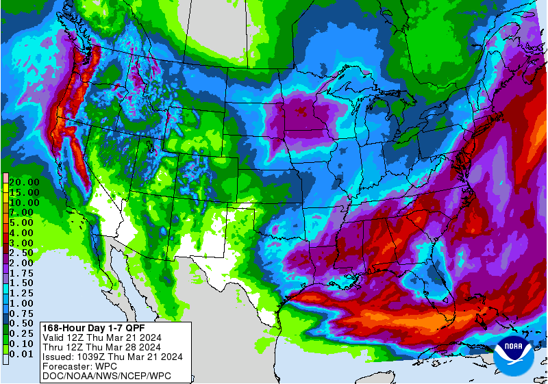
7 Day Total precipitation below:
http://www.wpc.ncep.noaa.govcdx /qpf/p168i.gif?1530796126
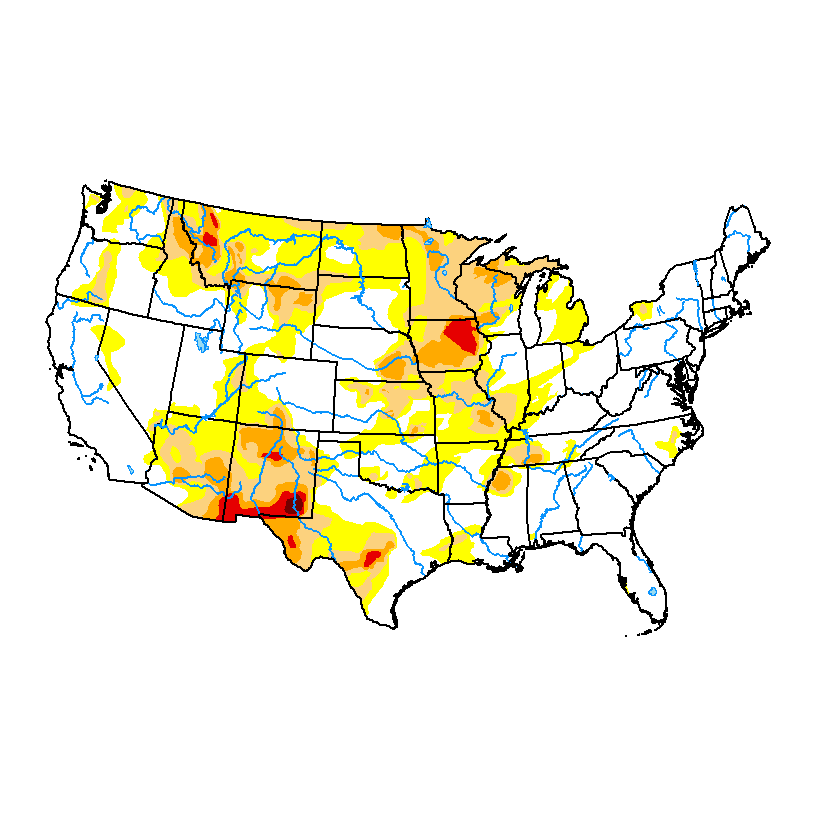
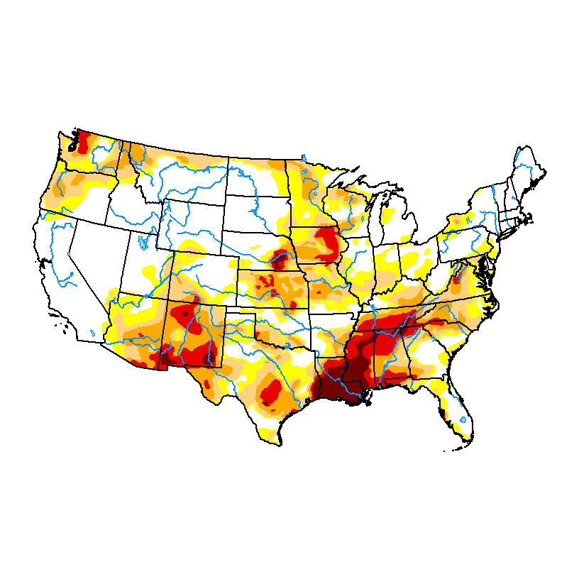
DROUGHT MONITOR
https://droughtmonitor.unl.edu/
Last week as of March 12, 2024
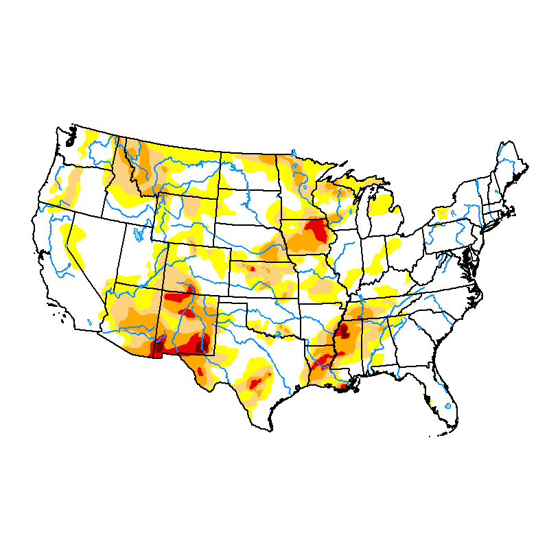
January 30, 2024 below
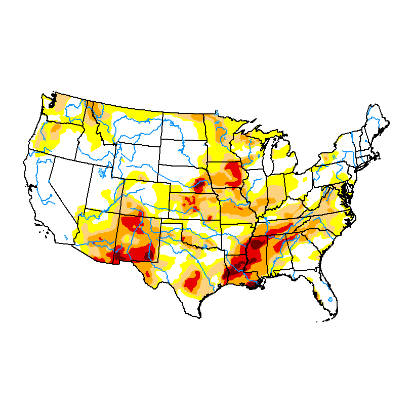
DECEMBER 12, 2023 below
NOVEMBER 14, 2023
from reports on the ground all that big snow never materialized for the very dry upper Midwest....some say less than an inch of snow. Some rains did develop further south out of that system
mcfarm,
Never materialized?
This is whats left of the first storm. 12+ inches in some spots....... a bit east from the forecasts last week.
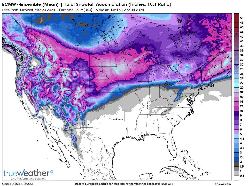
This is what's still on the way. Another 12+ inches is some spots. Added up, it matches up with the forecast below but instead of the heaviest snow in western MN, it's ending up in eastern MN.
This was the TOTAL snow forecast from all the systems last week(heaviest snows predicted in W. Minnesota, NOT E.Minnesota:
https://www.marketforum.com/forum/topic/102729/
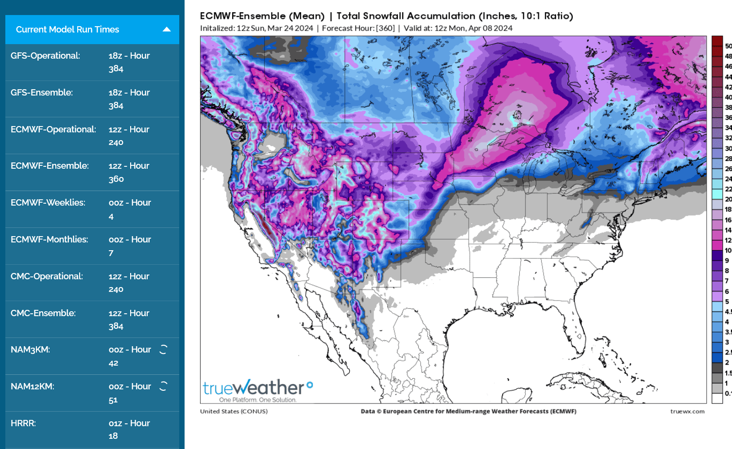
This one might be the worst of all. Total 2 week snowfall from the last 0z European model ensemble.
The bright blue is 20+ inches!
Again, this represents great moisture that soaks into an unfrozen soil when it melts!
mcfarm,
What source, please is telling you there was no big snow?
We can track tonight's huge Winter Storm below.
Winter Storm and Blizzards warnings across WI,MN,ND,NE,IA and nw KS.
https://www.marketforum.com/forum/topic/83844/
To see rain amounts, go here: https://www.iweathernet.com/total-rainfall-map-24-hours-to-72-hours
You can scroll down and get almost the entire comprehensive weather picture updated constantly here.
Current Hazards at the link below.
Go to the link below, hit hazards box in the top right hand corner(it will also define all the color codes), if its not already in the hazards mode when you load the link.
Then you can hit any spot on the map, including where you live and it will go to that NWS with all the comprehensive local weather information for that/your county.

New radar product below
Go to: "Select View" then "Local Radar"
Hit the purple circle to see that local radar site
+++++++++++++++++++++++
This link below provides some great data. After going to the link, hit "Mesoanalysis" then, the center of any box for the area that you want, then go to observation on the far left, then surface observations to get constantly updated surface observations or hit another of the dozens of choices.
 Found a great new link/site that shows us how much precip fell(from 1 hr to 72 hours) for different periods to share with you. https://www.iweathernet.com/total-rainfall-map-24-hours-to-72-hours Data Update Cycle: The 1-hr mosaic is updated every 5 min (approx). All other mosaics are now updated hourly, including the 48h and 72h maps. The site does not allow me to copy the actual images/data here, as we do with all the other links above..........so just go to the link! |
Current temperatures:
https://thermastor.com/dew-point-and-weather-maps/

Current Conditions below updated every few minutes.
UPPER MIDWEST
https://www.spc.noaa.gov/exper/mesoanalysis/new/viewsector.php?sector=13#


https://www.spc.noaa.gov/exper/mesoanalysis/new/viewsector.php?sector=13#

LOWER MIDWEST
https://www.spc.noaa.gov/exper/mesoanalysis/new/viewsector.php?sector=20

https://www.spc.noaa.gov/exper/mesoanalysis/new/viewsector.php?sector=20#

https://www.spc.noaa.gov/exper/mesoanalysis/new/viewsector.php?sector=20# 
guess I will restate that/ Reports from growers on he ground esp in the upper Midwest for example parts of the Dakotas was measured as an inch....first hand grower reports not mine
https://talk.newagtalk.com/forums/thread-view.asp?tid=1153535&mid=10677888#M10677888
Thanks, mcfarm,
That was extremely helpful!
it fits perfectly with the sensationalism!!
The extreme OVER THE TOP/hype of this storm, especially after the mildest Winter ever with very little snow, created extreme OVER anticipation everywhere.
Places that we’re not in the path of the big rains and snows because the track shifted we’re the ones that experienced the EXTREME DISAPPOINTMENT.
it’s not unusual for a winter storm track to shift And that always means precip amounts will also shift.
The disappointment from these guys is real because the shift in track took away the big snows for their location. I didn’t read every local forecast, everywhere for comparison but know the mentality of the forecasters and especially the media reporting EVERYTHING well.
they twist everything into the biggest or most or heaviest or driest or hottest ever. Describing the weather as Once in a century events and recently all these 1 in a thousand year events……that have happened several times at those locations just since accurate records started 130 years ago.
Recently, we had an enhanced severe weather threat here overnight. A threat at that level is less than moderate and much less than high risk.
We have that threat level numerous times each year, not usually at night but even that occurs a few times every year.
The media and others sources were freaking people out because their coverage amplified the real risk.
Now, when I do severe weather forecasting for people, I include reality checks to ground them to an understanding of the real risk. In almost all cases, the fear is much worse than the reality. And the sensationalized risk exploits peoples fears for ratings, attention and sometimes misplaced, sincere intentions to help prepare people.
https://www.marketforum.com/forum/topic/102510/#102520
https://www.marketforum.com/forum/topic/102662/#102668
The real risk of being killed by a tornado in your home is a very tiny fraction of being killed in a car crash for instance.
The media does not issue “enhanced car crash risk” or other alerts. When it rains, your car can’t stop as fast. When on the highway, speed kills.
We all know this and accept it as part of the every day risk which is part of having the enormous benefits of owning vehicles.
So we wear seatbelts and avoid distractions, like using electronics while driving……and love our lives.
With severe weather risks that are a minuscule fraction of the driving risks, we greatly elevate them and irrationally fear them.
Its important to respect them and to take the best actions to reduce them, when needed. Go to your basement in a strong tornado warning, for instance.
however, the amount of fear generated by a severe weather threat is 1,000 times amplified compared to a comparable risk for driving in a car.
Sensationalizing weather more and more has made this much worse recently!