
See all the comprehensive weather here:
https://www.marketforum.com/forum/topic/83844/
++++++++++++++++
Severe Storm Risk......updated daily(days 1 and 2 twice daily).
https://www.spc.noaa.gov/products/outlook/
Current Day 1 Outlook | |
Current Day 2 Outlook | |
Current Day 3 Outlook | |
Current Day 4-8 Outlook |
Many more pages to come!
Previous thread:
Severe weather, May 21, 2024 onward
9 responses |
Started by metmike - May 21, 2024, 3:11 p.m.
https://www.marketforum.com/forum/topic/104129/
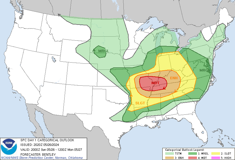
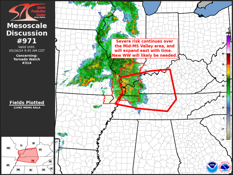
The next 3 days will feature the usual players in severe weather. All of them will contribute enough to generate a cumulative impact that results in at least an enhanced level 3 out of 5 threat, possibly as high as a moderate level 4 threat.
3pm Friday update: They just upgraded to a moderate risk on Saturday.
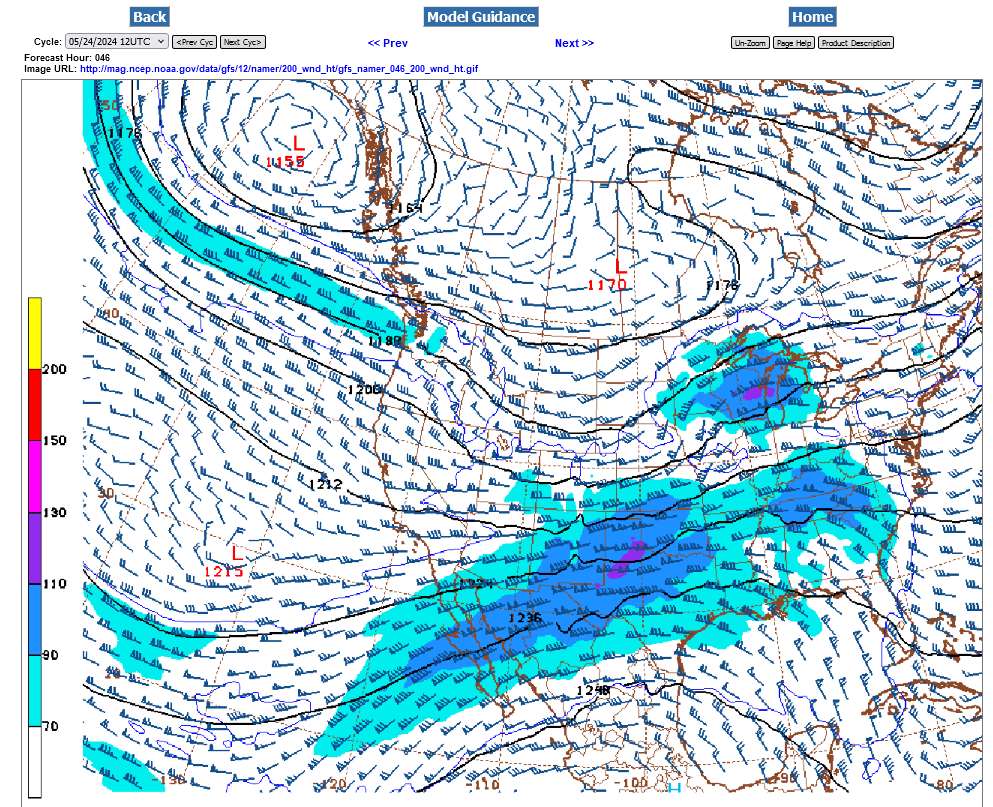
1. Moderately strong jet stream. Sunday's forecast below. (most violent tornado outbreaks are MORE impressive than this). Jet max/streak around 125 mph. Units below are in knots/hour.
2. Vorticity/spin in the atmosphere aimed at us. Sunday morning forecast below.
3. Very warm/humid/unstable air in place.
4. A number of surface fronts/boundaries to focus the lift.
Vorticity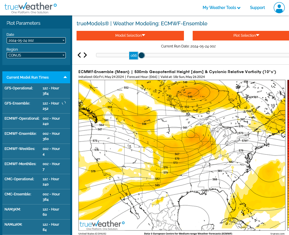
+++++++++++++++++++++++++++++++
National Wind Chill / Heat Index
https://thermastor.com/dew-point-and-weather-maps/

+++++++++++++++++++++++
1. Weather map now.
2. In 24 hours and
3. In 48 hours.
https://www.wpc.ncep.noaa.gov/#


Current Hazards at the link below.
Go to the link below, hit hazards box in the top right hand corner(it will also define all the color codes), if its not already in the hazards mode when you load the link.
Then you can hit any spot on the map, including where you live and it will go to that NWS with all the comprehensive local weather information for that/your county.

New radar product below
Go to: "Select View" then "Local Radar"
Hit the purple circle to see that local radar site
+++++++++++++++++++++++
This link below provides some great data. After going to the link, hit "Mesoanalysis" then, the center of any box for the area that you want, then go to observation on the far left, then surface observations to get constantly updated surface observations or hit another of the dozens of choices.
 |
With so many locations being impacted, if you want a local radar/information, just go to this link and click on the spot you want to see.
The NWS is having some issues with point location data at the moment which hopefully will be resolved quickly.
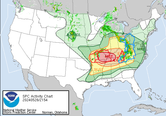
Breaking down the actual threats the next 2 days. These % numbers represent the chance of an event within 25 miles of any point on the map. The chance of it hitting any one spot is something like 10,000 times? LESS than this.
So even when we have the 45% hatched area on the maps right now for wind, it does not mean that a person living in that area has a 45% chance of high winds above 58 mph. It means that there is a 45% chance of a 58 mph wind WITHIN 25 miles of you!
Entire Explanation:
https://www.spc.noaa.gov/misc/SPC_probotlk_info.html
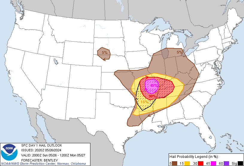
DAY 1!:
https://www.spc.noaa.gov/products/outlook/day1otlk.html
UPDATED 6PM SUNDAY:
Categorical:
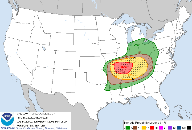
Tornadoes
Wind

Hail:
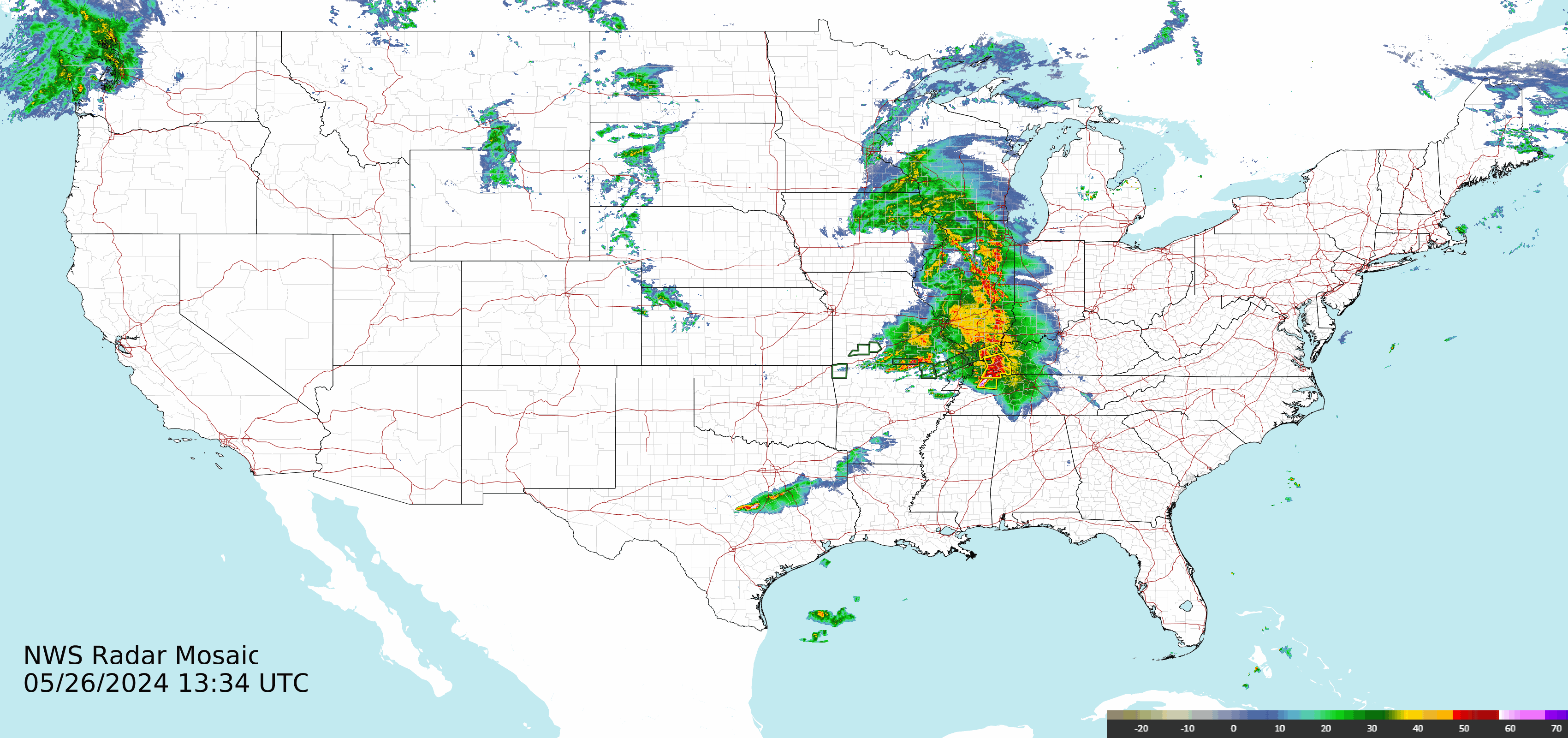
This has been a very stormy period!!
Storm reports the last 8 days. Last Sunday. We drove back from ND taking the MN/WI/IL/IN route to avoid those storms. Driving there, we went IN/IL/MO/NE/SD/ND.
The way back was an hour faster and I picked my own highways NOT all the ones that Google and Siri told us to take. In fact, we found Siri to be flawed a dozen times, sending us the wrong way or a longer way.
Last Sunday: 5-19-24
https://www.spc.noaa.gov/climo/reports/240519_rpts.html

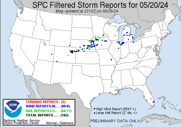
5-20-24 Monday
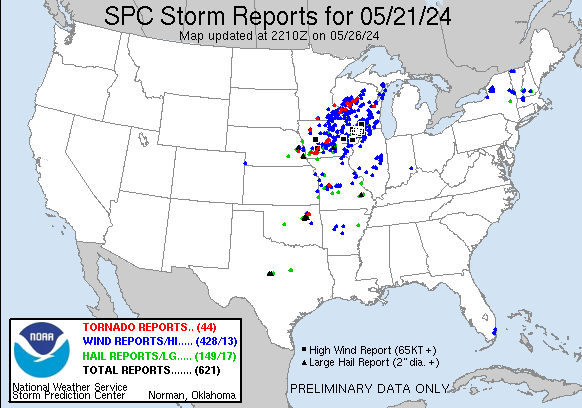
5-21-24 Tuesday
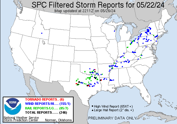
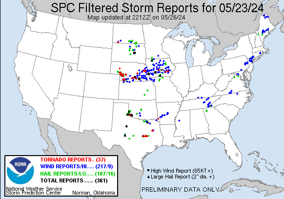
5-22/Wednesday
5-23/Thursday
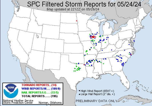
Friday:
https://www.spc.noaa.gov/climo/reports/240524_rpts.html
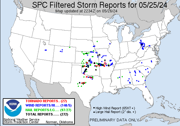
Saturday:
https://www.spc.noaa.gov/climo/reports/240525_rpts.html
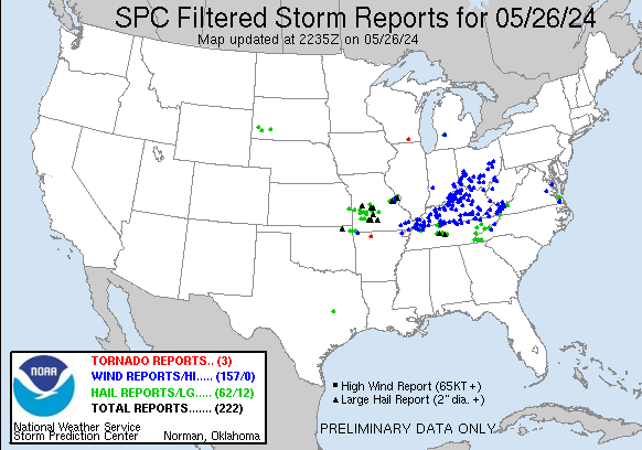
So far Sunday/today .......long way to go:
https://www.spc.noaa.gov/climo/reports/240526_rpts.html
https://www.wunderground.com/maps/radar/current

Current Hazards at the link below.
Go to the link below, hit hazards box in the top right hand corner(it will also define all the color codes), if its not already in the hazards mode when you load the link.
Then you can hit any spot on the map, including where you live and it will go to that NWS with all the comprehensive local weather information for that/your county.
New radar product below
Go to: "Select View" then "Local Radar"
Hit the purple circle to see that local radar site
+++++++++++++++++++++++
This link below provides some great data. After going to the link, hit "Mesoanalysis" then, the center of any box for the area that you want, then go to observation on the far left, then surface observations to get constantly updated surface observations or hit another of the dozens of choices.
| |

Central Illinois
NWS Forecast Office Lincoln, IL
Click a location below for detailed forecast.

Click a location below for detailed forecast.

++++++
NWS Forecast Office Indianapolis, IN

5-26-24: Areas farther south:
Shreveport, LA

+++++++++++++++++

L
 NWS Nashville (KOHX) Radar Loop

++++++++++++++++

+++++++++++

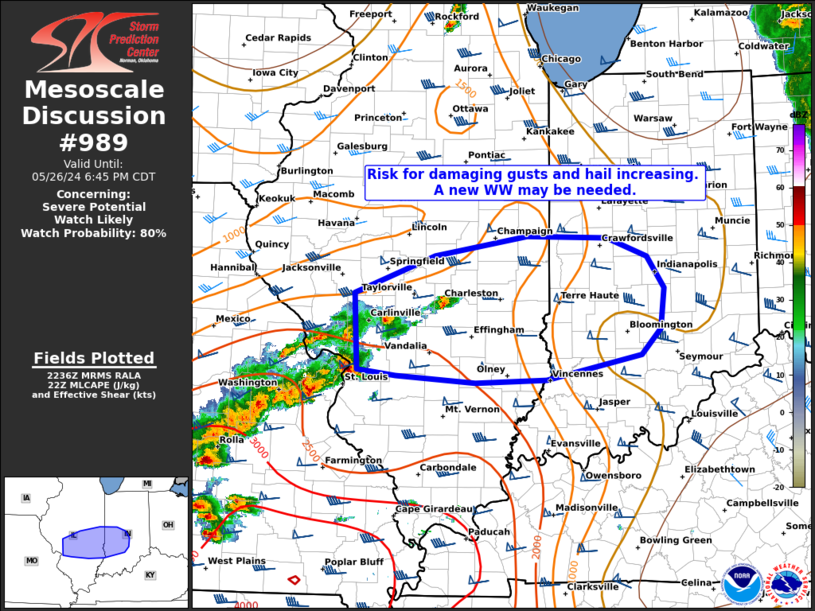
Storm Prediction Center getting ready to issue a new tornado watch!
https://www.spc.noaa.gov/
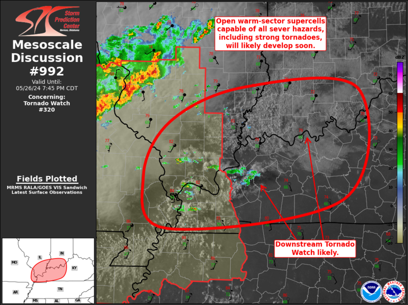
STAY SAFE, MIKE!
WOW!
6 different colors on our local map right now!!!!!
The oranges are severe thunderstorm WARNINGS. The BRIGHT RED ARE TORNADO WARNINGS!
++++++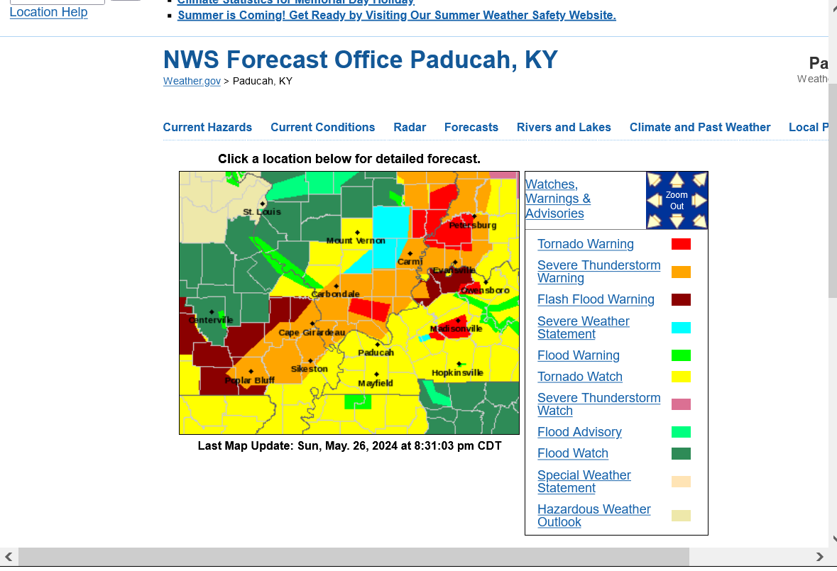
The risk for severe weather has passed east of Evansville, despite the tornado watch still in effect.
GOOD FOR EVANSVILLE!!
THE LINK IN MY PREVIOUS POST, HAS LIVE VIDEO FROM THE CHASERS. THOSE GIANT TORNADOES DON'T EVEN LOOK REAL!
Thanks, Jean!
Great reporting from your guy:
https://www.youtube.com/watch?v=fITfYtCMd98
We get to watch the best guy that I've ever seen on one of our local stations.
Wayne Hart on WEHT-ABC.
He actually replaced me in 1993!
This is the Storm Report from yesterday/Sunday.
https://www.spc.noaa.gov/climo/reports/240526_rpts.html
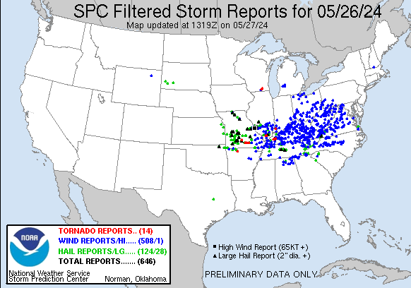
There are some things to note.
1. The number of high wind reports, 791 was incredibly high. It came from 2 separate, huge convective complexes. 1 in the morning, the other in the evening. These type of storms cause massive amounts of damage but not many fatalities.
2. Only 15 tornadoes. VIOLENT, long track tornadoes cause most fatalities. We had 1 of those in Western KY Sunday evening.
3. All day, the Storm Prediction Center noted it to be a particularly dangerous situation and the media went bonkers, scaring a lot of people that I know in Evansville. This is the statement that I sent out to the 1,000 people that I emailed:
"We've had a risk level this high ~100 times in the past decade and even higher ~20+ times.
In recent years the coverage and sensationalizing makes it seem worse.
If a severe thunderstorm warning is issued, be in a sturdy building and stay away from windows.
With a tornado warning, follow the advice at this link.
Very few tornadoes have the 150+ mph winds that take lives. That type of tornado usually has a long track history before it hits. If you're following the weather closely, you will usually see/read that being reported from a storm well before the tornado warning is issued for our county.
It's those rare situations when its imperative to go to the safest place in the house.
Chances are small that will happen later this evening but conditions may cause a few strong tornadoes somewhere within 300 miles of Evansville."
https://emsaonline.com/
4. Supporting that above statement, 2 days prior to the severe storm outbreak, this statement was made:
https://www.spc.noaa.gov/climo/reports/240526_rpts.html
1. Moderately strong jet stream. Sunday's forecast below. (most violent tornado outbreaks are MORE impressive than this). Jet max/streak around 125 mph.
++++++++++++++
The point of this is not to bash the Severe Storm Center because they do a SUPER DUPER job and save thousands of lives every year and us meteorologists are just passing along their wonderful guidance that includes watches and technical discussions but instead to point out something else.
We live in an age of advanced technology. This affords us much more information than the past. This includes video of every tornado and video footage of enormous damage from the violent tornadoes. When that information is about extreme weather events, it gets amplified, sensationalized and embellished WITHOUT PERSPECTIVE.
When people heard "particularly dangerous situation" yesterday, along with all sorts of implications added from various sources, it can feel/seem like killer tornado Armageddon is coming.
This has unquestionably amplified severe weather phobia in recent years. As a television meteorologist in the Stone Age(1982-1993). I dealt with numerous people who were afflicted with this to the point of it being pathological. They would contact me anytime we had thunderstorms in the forecast. I had one poor lady that was so bad that she might call me when she saw black clouds on the horizon.
The point is that I understand this mentality/phobia and IT HAS INCREASED because of the technology and sensationalizing. Don't get me wrong. The technology is saving many lives and it MUST BE taken seriously to be effective. However, the downside is the increase in severe weather phobia and anxiety ramping up.
Let's discuss/learn more about this with advice to assist people!
+++++++++++++++++++++
In our area, we will see storms every year, and unfortunately, there’s nothing we can do to stop them. This can make you feel powerless. But there is a way to empower yourself and that’s through knowledge and preparation. It can be helpful to think about what exactly it is about severe weather or storms that makes you afraid, stressed or nervous, Knowing what it is that makes you stressed or anxious can help you find ways to deal with that stress and anxiety.
https://www.weather.gov/oun/stormanxiety
 Regional Radar
 Shreveport Radar
 Local Radar