PREVIOUS THREAD:
Grains 4-22-24+
67 responses |
Started by metmike - April 22, 2024, 3:09 p.m.
https://www.marketforum.com/forum/topic/103397/
++++++++++++++++++++++++++++
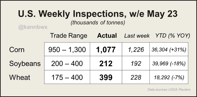
U.S. export inspections last week were within range of expectations, #wheat at the top end. Just one cargo each of #corn, #soybeans & #sorghum were inspected for China.
USDA confirms the sale of 215,000 tonnes of U.S. #corn for delivery to Mexico. 165kt is for 23/24 and 50kt is for 24/25.
POTENTIAL from the weather pattern to turn bullish/dry in early June:
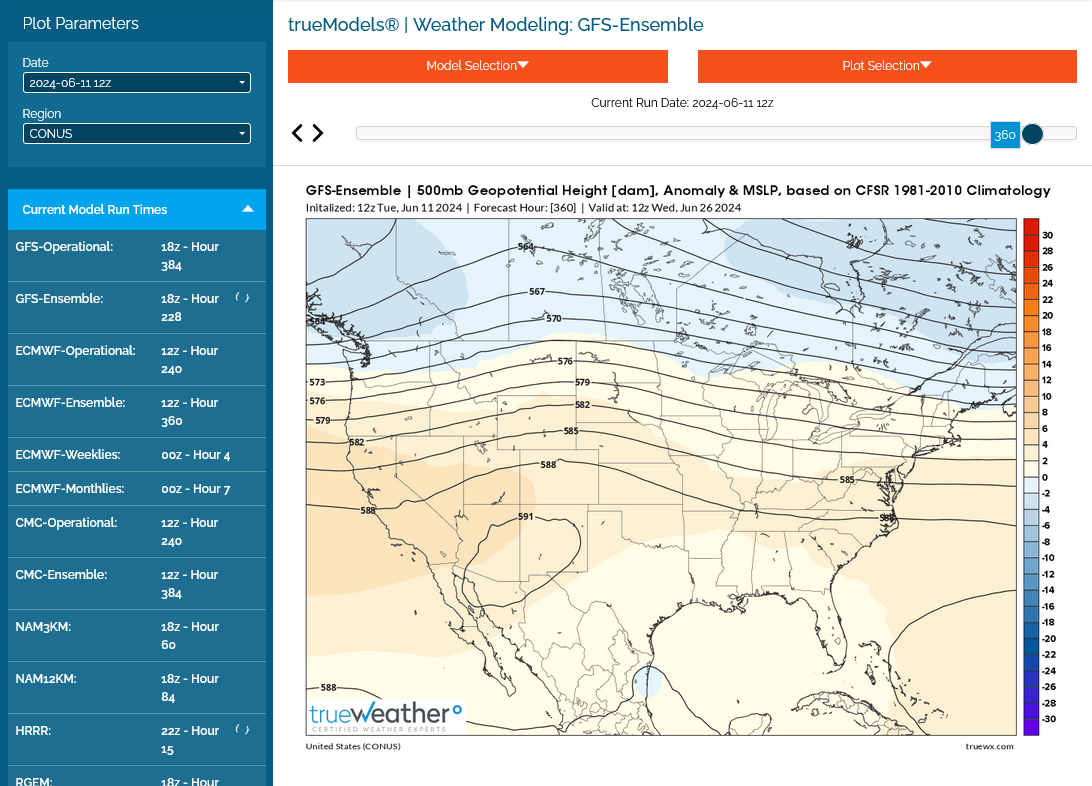
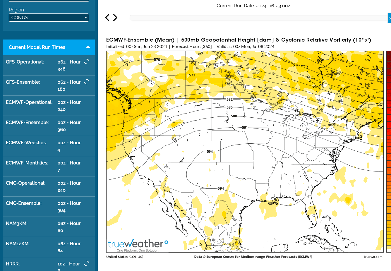
This was the last 0z European model solution for 12 days at 500 mb.
Gulf moisture is cut off and temps are very cool in the Eastern Cornbelt with potential northwest flow/reinforcing cold fronts.
The Plains look dry with some heat.


++++++++++++++++
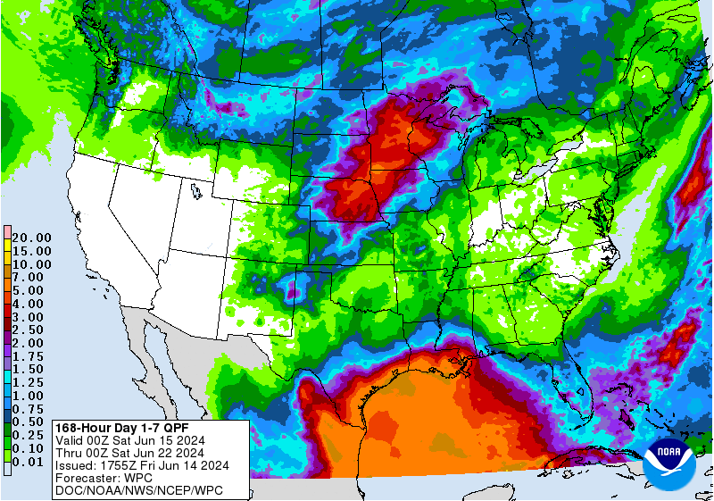
Enough rain coming up the next week to keep that concern at bay, along with much of the crop still needing to be planted after robust rains have restored soil moisture in most places:
7 Day Total precipitation below:
http://www.wpc.ncep.noaa.govcdx /qpf/p168i.gif?1530796126

+++++++++++
https://www.cpc.ncep.noaa.gov/products/Soilmst_Monitoring/US/Soilmst/Soilmst.shtml#
![]()


++++++++++++++++++++++++++++
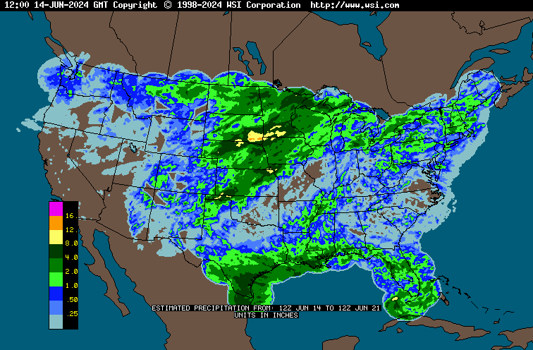
Updated daily below:
https://mrcc.purdue.edu/cliwatch/watch.htm#curMonths

DROUGHT MONITOR
https://droughtmonitor.unl.edu/
Last week as of May 21, 2024-no drought in California from the Winter El Nino. Most drought in the Midwest wiped out!
All the weather is here:
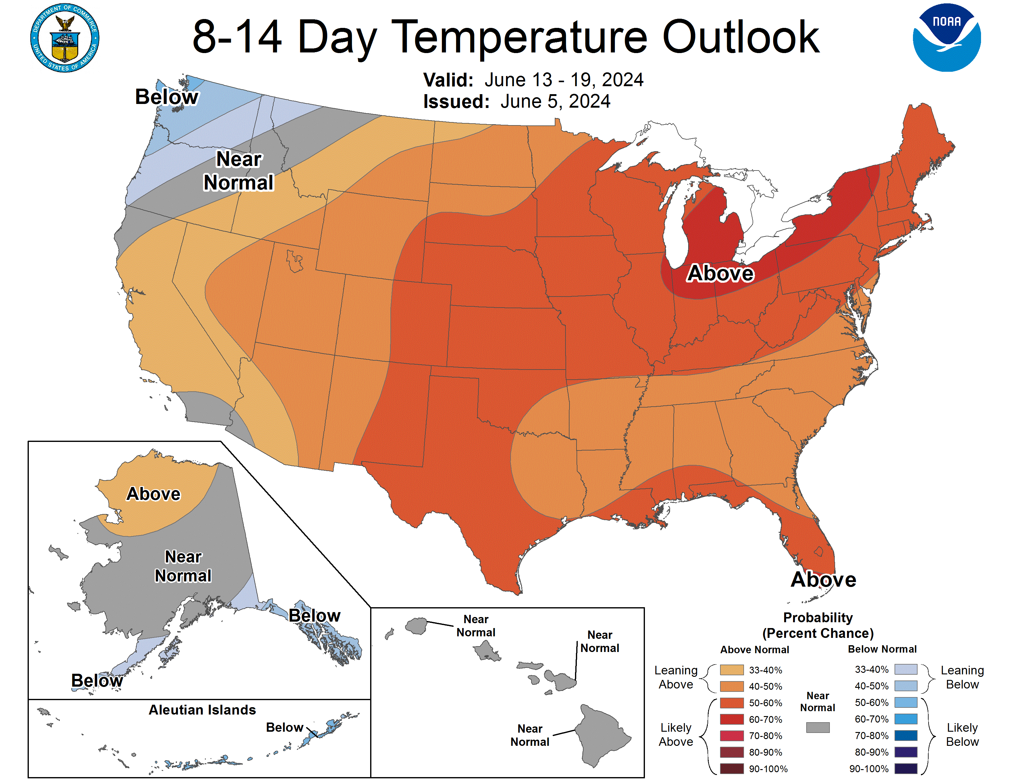
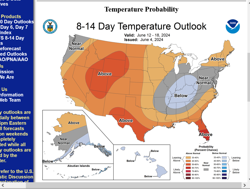
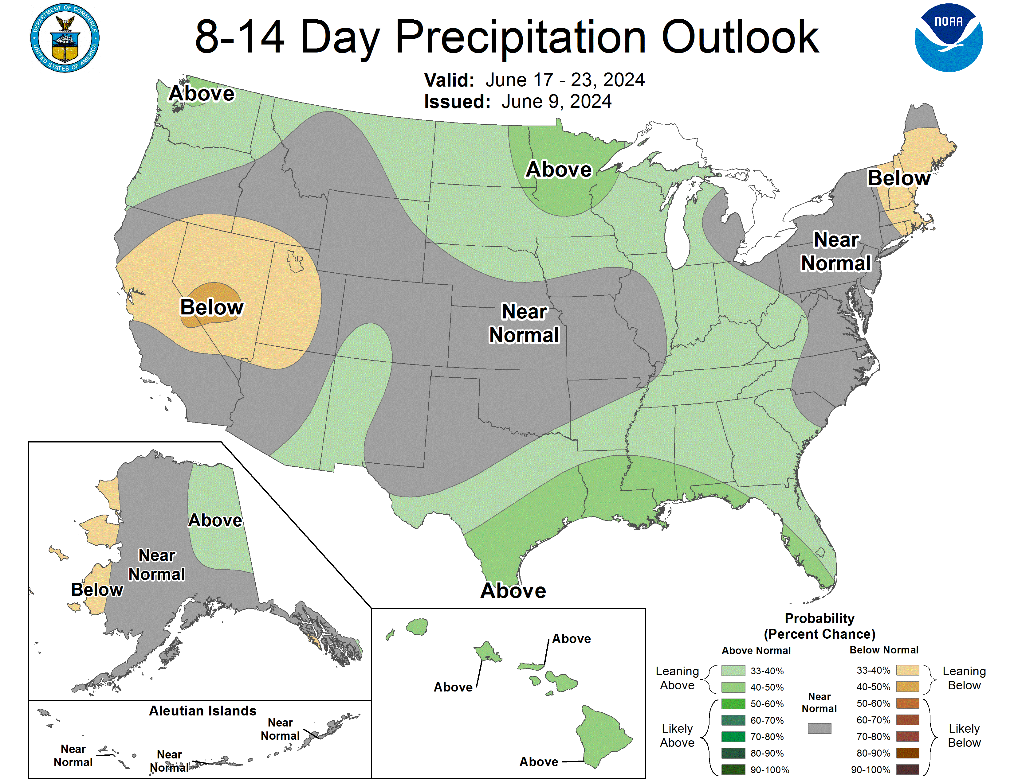
This was the week 2 weather update:
https://www.cpc.ncep.noaa.gov/products/predictions/814day/index.php
| 8 to 14 Day Outlooks | |
| Click below for information about how to read 6-10 day outlook maps Temperature Precipitation | |
| Click below for archives of past outlooks (data & graphics), historical analogs to todays forecast, and other formats of the 8-14 day outlooks ArchivesAnalogsLines-Only FormatGIS Data | |
Temperature Probability | |
Precipitation Probability | |
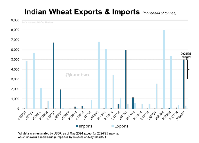
India had stepped in with record exports in 2021/22 when the Ukraine crisis began and wheat prices skyrocketed. But India's state wheat supplies have fallen to 16-year lows and domestic prices have been relatively high since early 2022.
#India is likely to scrap its 40% duty on #wheat imports after June, possibly creating 3-5 million tonnes of imports this season. That would make India roughly the 11th largest wheat importer in 2024/25. FYI wheat stocks/use among major exporters is set for a 17yr low in 24/25
#China's COFCO on Friday landed its first cargo of deforestation-free #soybeans for domestic use, a 50,000-tonne shipment from #Brazil worth $30M.
++++++++++++++
metmike: This is new to me and my first impression is that its a bunch of hogwash being used to charge more for certain soybeans. As an environmentalist, I will stay opened minded to see positives for the environment.
Cargill supports a variety of pathways for delivering certified sustainable soy products to meet growing global demand for responsibly produced soy.
please point to an acre that once was not forest..,,, and is farmable,,...more lunacy from the left....as John Wayne said...."even the government knows you cannot farm 6 thousand feet above sea level."
Great point, mcfarm!
We can imagine how difficult it was before combustion engines and fossil fuels!
200+ years ago when they had to use horses/oxen and axes, clearing a dozen acres that a family needed to produce their own food could take years!
Getting the stumps out was the toughest part, especially for certain kinds of trees!
Times were so different.
![]()
https://gwentuinman.com/2018/05/26/how-settlers-cleared-their-land/
THIS PAST TUESDAY... WHILE DRIVING 10 MILES WITH FIELDS ON BOTH SIDES OF THE HIGHWAY... I SAW NO CORN OR BEANS. ONE FIELD, I BELIEVE WAS WHEAT, ABOUT 15" TALL. THE FIELDS WERE BASICALLY ALL WORKED & SPRAYED, 'THO...THE WEEDS WERE WILTED & YELLOW.
NOTHING HAD SURFACED IN THE 60 ACRES ACROSS THE ROAD FROM ME.
Thanks, Jean.
https://www.nass.usda.gov/Publications/Todays_Reports/reports/prog2124.pdf
Ohio got a ton of the crop planted the previous week. Going from 46% to 79% corn planted in just 1 week which was faster than the average of 64%. OH, ND and SD are the only 3 states ahead of the average pace by double digits. IN had 73% of the corn planted, a tad faster than the 71% average,
In OH, Beans were 67% planted compared to 41% the previous week and average of 54%. IN beans are 69% done vs the average of just 60%.
Despite all the rains that have wiped out the drought, no STATES are very far behind in planting.
++++++++++++++++
I'm seeing strong signals for a pattern change late in week 2 with the big upper ridge in the West shifting eastward into the Plains.
The cool and mostly dry weather should start heating up in mid June!
Extended weather:
https://www.cpc.ncep.noaa.gov/products/predictions/610day/ | |
| 6 to 10 day outlooks | |
| Click below for information about how to read 6-10 day outlook maps Temperature Precipitation | |
| Click below for archives of past outlooks (data & graphics), historical analogs to todays forecast, and other formats of the 6-10 day outlooks ArchivesAnalogsLines-Only FormatGIS Data | |
Temperature Probability | |
Precipitation Probability | |
| 8 to 14 Day Outlooks | |
| Click below for information about how to read 6-10 day outlook maps Temperature Precipitation | |
| Click below for archives of past outlooks (data & graphics), historical analogs to todays forecast, and other formats of the 8-14 day outlooks ArchivesAnalogsLines-Only FormatGIS Data | |
| Temperature Probability | |
| Precipitation Probability | |
++++++++++++++
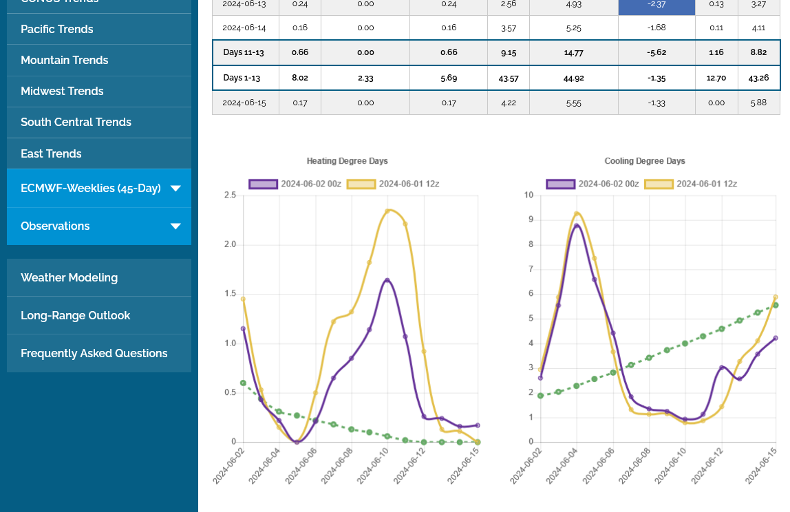
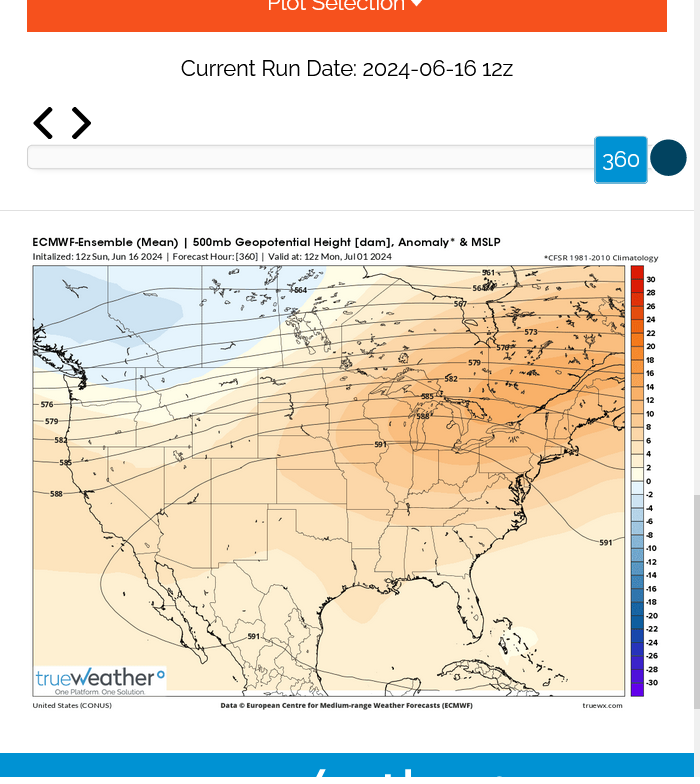
Check out these CDD maps for the next 2 weeks from the just updated 0z European Ensemble model in purple on the right.
1. The Pacific region: normal increases slowly from just 1.5 to 2.5 as seen with the green line on the right during the 2 weeks below. Residential cooling demand can spike up like this during heat waves but is usually MUCH, MUCH less than the Midwest, East and South where the overall population is greater and hot/HUMID weather is more common. Heat waves in the West have MUCH lower humidities than in the East(but this contributes to wildfires). During this upcoming week, near record heat out West will briefly spike the CDDs to 7 which is around 4 times the normal. It stays hot out there in week 2 as the heat shifts farther east
2. The Midwest region on the 2nd map sees an average increase in CDDs (in green on the right) from 2.5 to an increasingly substantial 6 by mid June. After a very brief spike to 9 to start this week, temps plunge and CDDs are MUCH BELOW AVERAGE for an extended period but start recovering late in week 2.
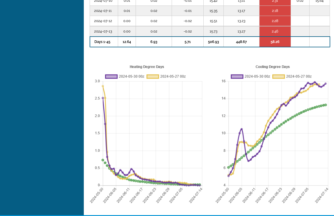
3. This is the 45 day outlook for the entire country from the last European model run late last week. You can see how the first 2 weeks look more like the Midwest's signature because the Midwest counts so much more than the West/Pacific. What stands out is the rapidly building heat! Temps go ABOVE average during mid month and stay sustained WELL ABOVE AVERAGE THRU MID-JULY. This is POTENTIALLY bullish NG AND grains.
4. Mid June Upper levels
5. Drought monitor: Great shape everywhere........except KS that will get hurt in late June with intense heat.
++++++++++++++++++++++
45 days for entire country below:
++++++++++++++++++++++++
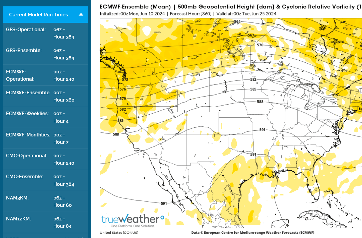
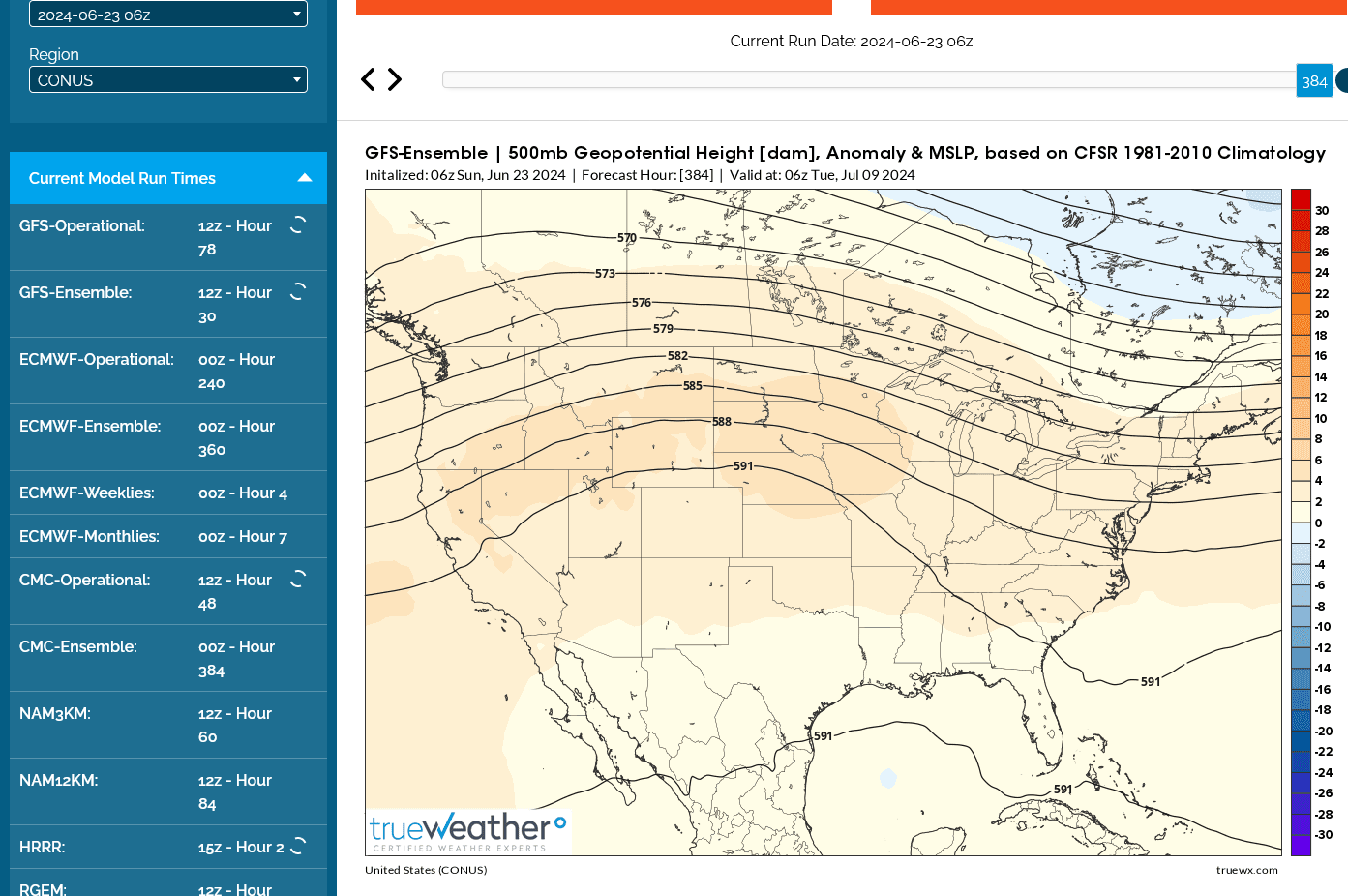
4. Upper levels mid June with individual ensembles from Canadian model. Upper level ridge shifts east. How strong? What location? Hot and dry will become a worry in the 2nd half of June for some locations!
384h GZ 500 forecast valid on Jun 18, 2024 00UTC


Forecasts for global GEM, control (GE
5. Drought monitor: Midwest in great shape overall but NOT, KS. KS wheat which is filling will likely get hurt in late June with the new pattern.
Last week as of May 28, 2024-no drought in California from the Winter El Nino. Most drought in the Midwest is wiped out completely!
DROUGHT MONITOR
https://droughtmonitor.unl.edu/

KC wheat +7c from the pattern noted above, roasting KS later this month during wheat fill with low soil moisture!
KC wheat spike to almost +20c just after 8am and has been under pressure since then.
Now -8c.
+++++++++++++++++++++++++++++++
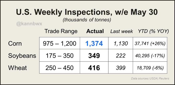
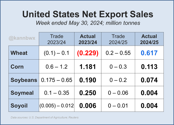
Twitter is acting glitchy for me, unsure if this posted correctly, so here it is again: Last week's US export inspections were strong versus expectations - #corn above, #soybeans at the top and #wheat near the top. Two corn cargoes inspected for China at PNW and one bean at Gulf.
++++++++++++++++++++++
USDA confirms the sale of 110,000 tonnes of U.S. #corn for delivery to Spain in 2023/24.
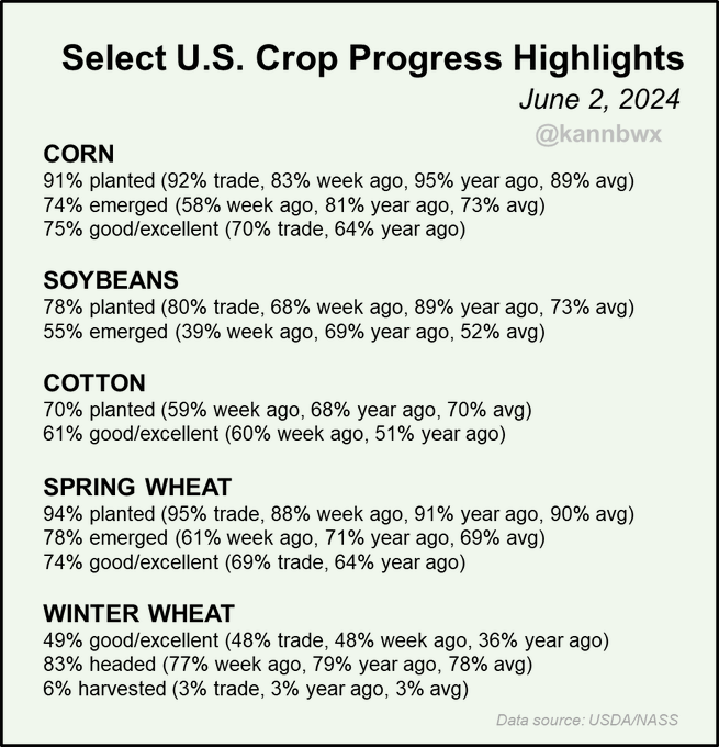
Crop condition:
Corn and Spring Wheat were much better than expected!
+++++++++++++++++++++++++
USDA rates 75% of U.S. #corn in good/excellent condition and spring #wheat 74% g/e, both 5 pct points above expectations. Planting was overall a little slower than expected last week, but winter wheat harvest was quicker.
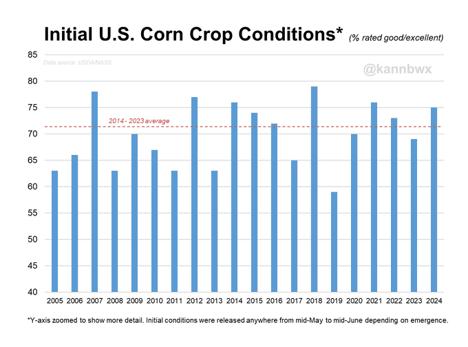
U.S. #corn conditions by state as of June 2 versus the same week a year ago. Keep in mind that emergence is at 74%, meaning 26% has yet to factor in.
U.S. #corn starting at 75% good-to-excellent is the 6th best start of the last 20 years and the best since 2021. People always point out 2012's great start - yes, things can certainly turn. In the nearer term, a quarter of the crop has yet to emerge. Let's see how that looks.
++++++++++++++++++
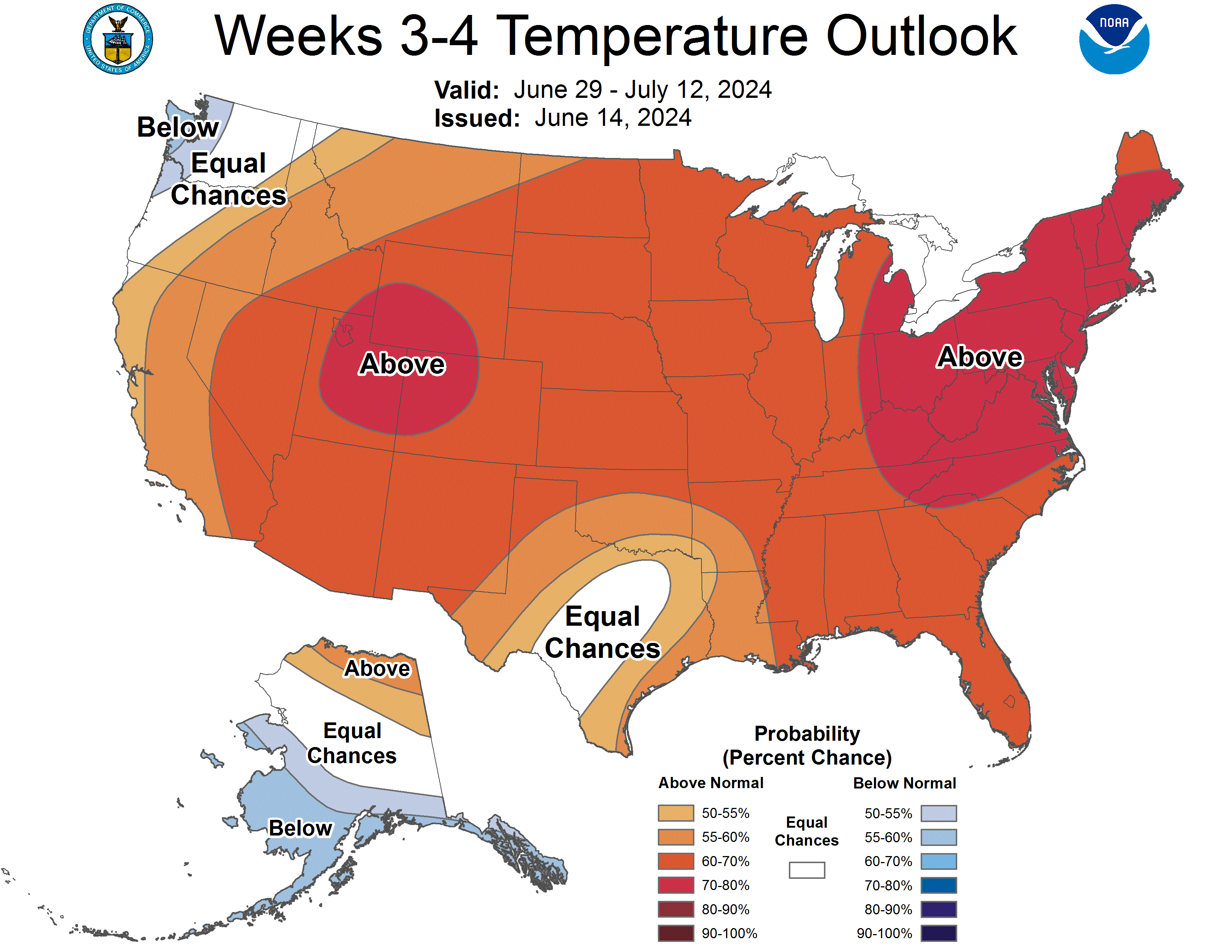
Pretty good start but the 2nd half of June is likely to feature HOT and possibly dry weather!
Although it will be hard to build a "dome of death" over widespread moist soils. What tends to happen is that all that moisture/vegetation creates a micro climate.
Not only inducing some cooling, it also recycles the moisture that comes out with evapotranspiration, that acts as a source for moisture with storm clusters that tend to ride the periphery of the heat ridge and keep bashing it back, instead of letting it expand...........which would happen over dry soils.
The 2nd half of June is going to turn HOT!
NWS finally catching on to the hotter pattern change today:
https://www.cpc.ncep.noaa.gov/products/predictions/814day/index.php
Canadian model and ensembles, 2 weeks from today, below:
https://weather.gc.ca/ensemble/charts_e.html?Hour=384&Day=0&RunTime=12&Type=gz
384h GZ 500 forecast valid on Jun 20, 2024 12 UTC


Again, building a big "dome of death" across the entire Midwest will be difficult initially because of widespread moist soils.
The latest model runs are confirming the big upper level ridge for the 2nd half of June.
It's got NG excited but the grains have yet to react(with robust soil moisture right now and still some planting to finish) AND corn's initial crop rating at 75% G/E.
https://weather.gc.ca/ensemble/charts_e.html?Hour=384&Day=0&RunTime=00&Type=gz
384h GZ 500 forecast valid on Jun 21, 2024 00 UTC


Grains are finally reacting to the heat ridge coming in during the 2nd half of June!
Last 0z Canadian model:
https://weather.gc.ca/ensemble/charts_e.html?Hour=384&Day=0&RunTime=00&Type=gz
384h GZ 500 forecast valid on Jun 22, 2024 00 UTC


USDA confirms the sale of 152,000 tonnes of U.S. #corn for delivery to unknown destinations in 2023/24.
Very little activity again last week for U.S. #soybean export sales, but old-crop #corn was near the top end of expectations, led by Mexico and Japan. #China had two corn cargoes switched from unknown upon shipment, and China also booked its first new-crop #wheat cargo.
The lows are in for corn/beans!
8am Added: I may have spoke too soon.
The overnight guidance added alot of rain in the Western/Central belt.
we need a higher close today
I agree, cutworm!
The problem with building a widespread bullish heat ridge in at this time of year, as noted a couple of times this week.......are the moist soils and tightly packed rows of corn creating a MICRO climate in the Midwest.
It's the biggest reason for climate change in the Midwest the past 3 decades to mean COOLER SUMMER'S with MORE RAINFALL.
Evapotranspiration and photosynthesis are negative feedbacks for greenhouse gas warming DURING THE DAYTIME IN THE SUMMER'S.
Night's are warmer and more muggy. Winter's are warmer(no vegetation) but make no mistake, Summers in the Cornbelt have featured less extreme high temps with 100% certainty.
The weather models don't do a great job dialing that into their solutions.
+++++++++++

++++++++++++
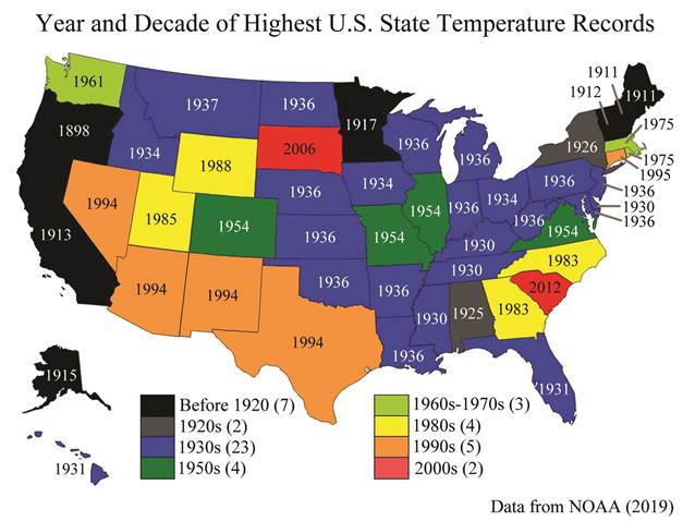
https://en.wikipedia.org/wiki/U.S._state_and_territory_temperature_extremes
The graphic below was made just before OR, WA and CO broke their records.
 |
From the EPA, Figure 3. Used to be their front page.
https://www.epa.gov/climate-indicators/climate-change-indicators-heat-waves
Image(s) #5. Heat waves and drought in the 1930s. Can we have both of these images on the same page, please.  | ||
The data.........is the data??? But note the slight of hand by the EPA to change their front page to THIS data below around 6 years ago, which intentionally starts after global cooling of the 40's-50's-60's ended. The blatantly misleading impact on people using the different data starting points is profound.  |
The EPA initially disposed of the front page, starting with 1890 that they'd used for over a decade and replaced it with the graphics above. Then, there was massive blow back and legit accusations of data manipulation, so they added it back as figure 3.
Nobody can convince me that these government scientists and bureaucrats are objective and honest when it comes to climate change. They are not. This is just one especially obvious and easy to prove example.
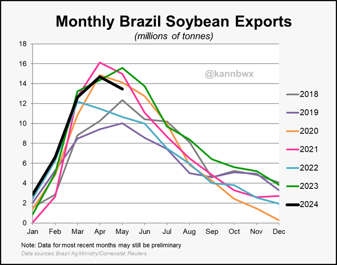
Preliminary data shows #Brazil exported 13.45 million tonnes (494 million bushels) of #soybeans in May, down 14% from last May and slightly below the three-year average. Between January and April, some 70% of Brazil's soybean exports went to #China.
+++++++++++++
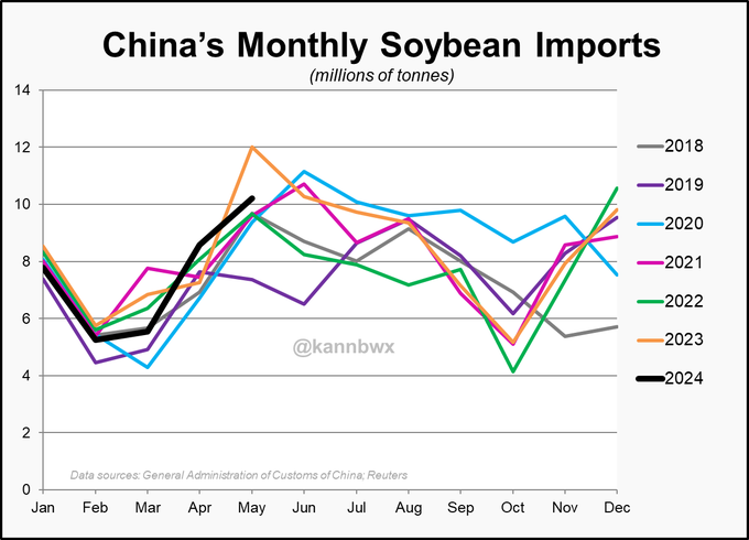
#China imported 10.22 million tonnes (376 million bushels) of #soybeans in May, the month's second best but down 15% from last year's record. Arrivals of 11-12 mmt had been expected.
Here's the original story from Tuesday, when this measure was announced:
USDA confirms the sale of 104,000 tonnes of U.S. #soybeans for delivery to #China in 2023/24.
+++++++++++++++++++++++
U.S. #ethanol exports in April at 811M liters (214M gallons) were the second highest for any month on record and up 51% from the 3yr April avg. Canada accounted for 29%, United Kingdom 16% and India 9%. Huge monthly record for US ethanol exports to the UK.
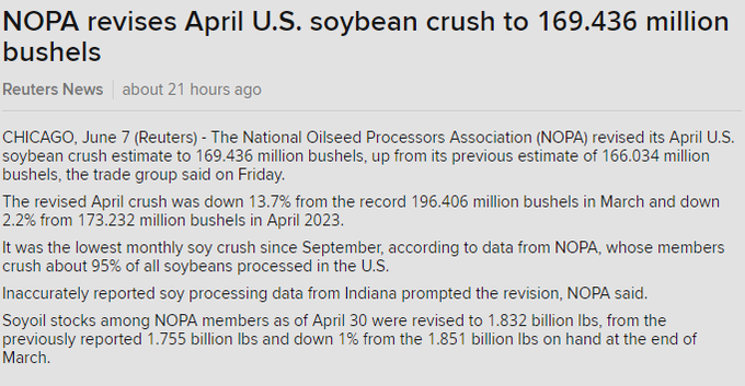
NOPA on Friday revised U.S. crush data for April 2024:169.436 million bushels of #soybeans processedWAS 166.034 mlnStill below all trade estimates#Soyoil stocks 1.832 bln lbsWAS 1.755 blnStill below avg trade guess but no longer below range
The revision was based on inaccurately reported data from Indiana:
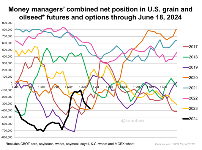
It's a bit early in the U.S. growing season for funds to be selling off #corn, but that's what they did in the week ended June 4. Money managers expanded their net long by nearly 80k fut&opt contracts to 212,706 contracts, a five-week high. Futures were down 4.3% in the week.
++++++++++++++++++++++++++++++++++
metmike: The 75% G/E first corn rating was a big factor!
https://www.marketforum.com/forum/topic/104311/#104538
The next rest of June is going to start featuring heat with some areas drying up(especially the Eastern Cornbelt).......other areas will have enough rain to do well.......grow fast in the vegetative state with the heat accumulating Growing Degree Days for corn.
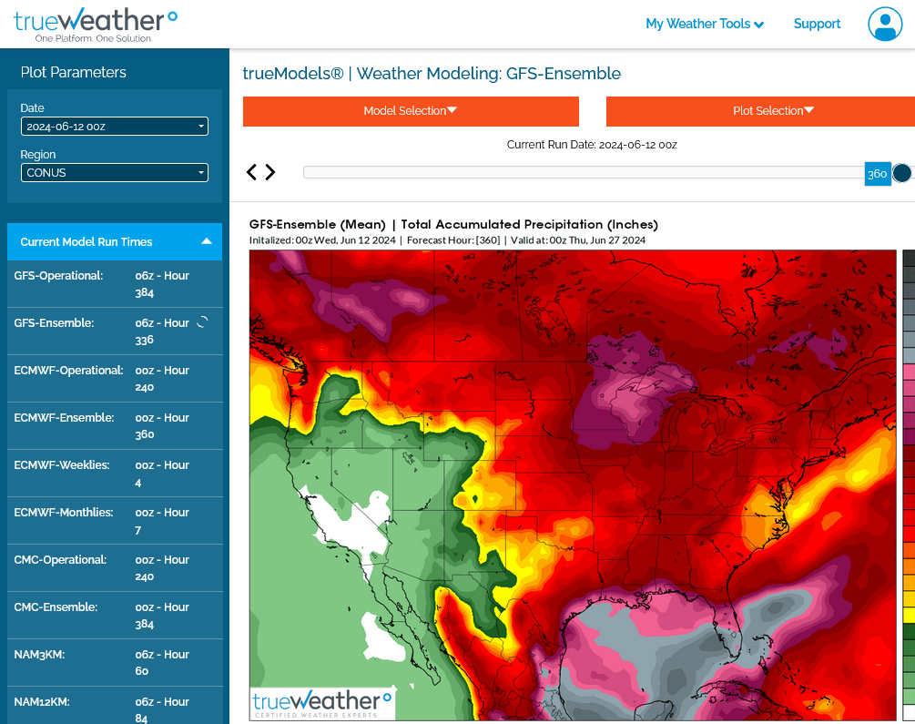
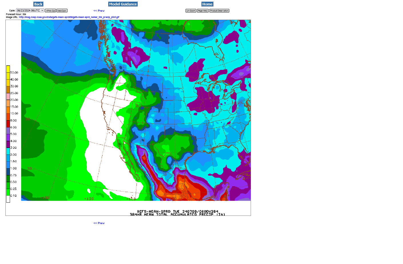
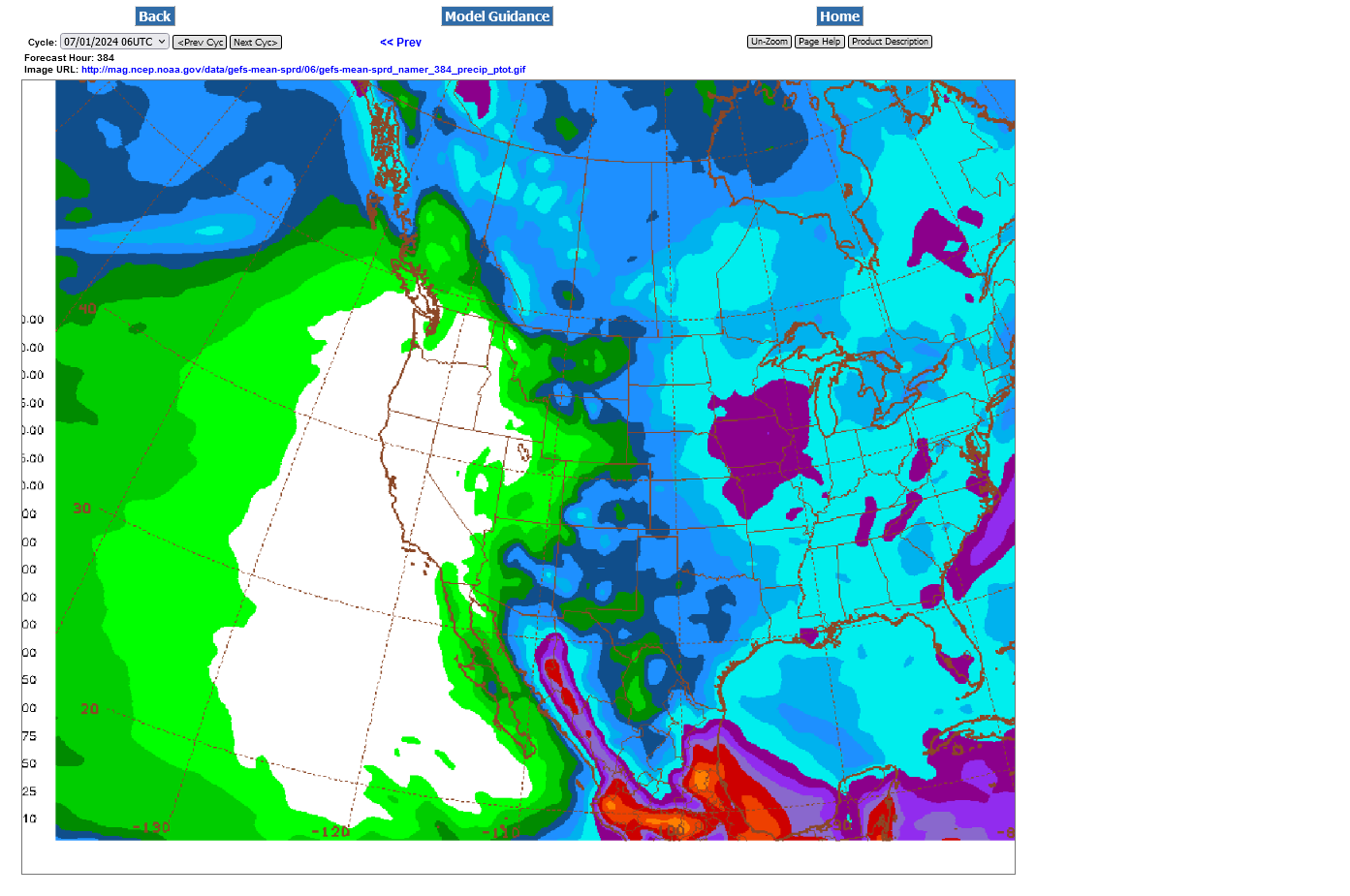
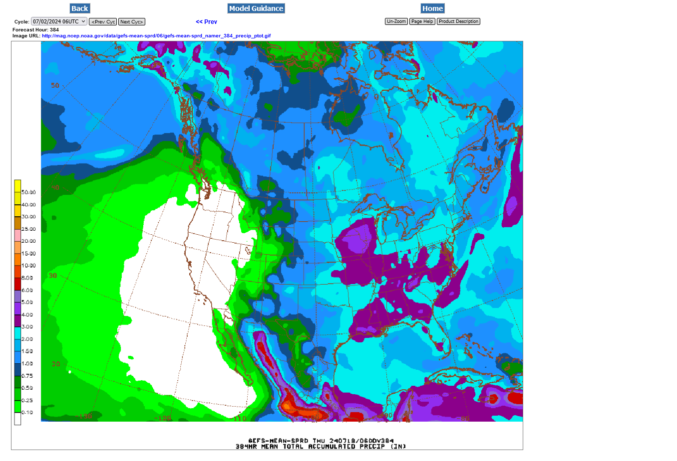
This was the last 12z GEFS run for total rains the next 384 hours.
Light blue is 2+ inches.
We're barely missing a nice rain to our south this morning. OUCH!
Because the prospects for rain here in the ECB the next 2 weeks are not very good, along with some heat later next week.
It's been almost a week since our last rain too. You can go to this link and get a regional shot.
https://www.eldoradoweather.com/radar/national-doppler-radar-full-resolution.html
Latest 384 hour total rains from this last 18z GEFS. Not enough in the ECB to keep up with the heat on the way. However,
1. The soils are charged up with water
2. The Upper Midwest should have good rains, with a ring of fire pattern as perturbations ride the periphery of the upper level ridge and fire up t-storms in the very warm/hot humid air, assisted by increasing evapotranspiration rates from the growing/greening crop and moist soils.
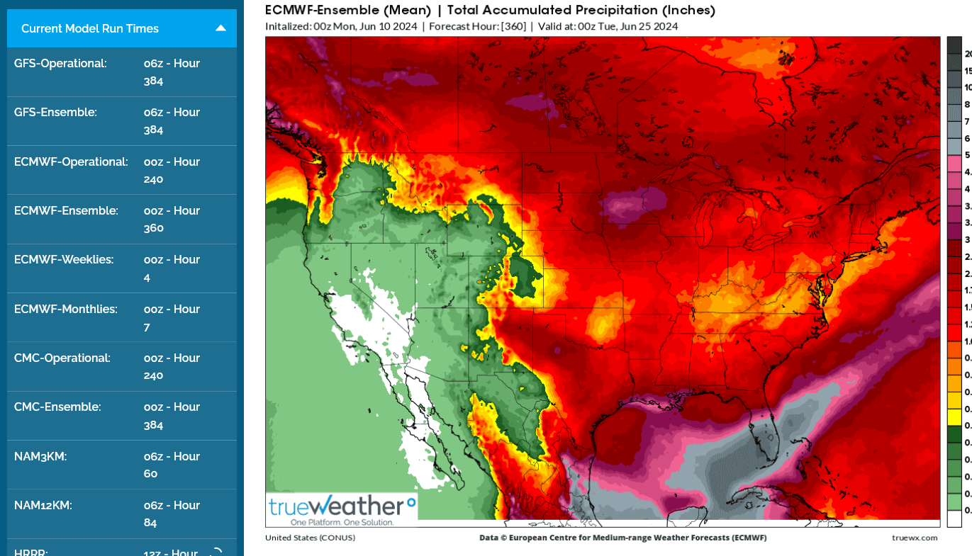
3. The storm clusters may lose support tracking southeast into the ECB. 4. This is the upper level, 500 mb map below in 2 weeks.
The center of the current heat ridge after spreading across the Midwest and East, could back up towards the southwest with a BERMUDA HIGH building into the far southeast/FL and a weakness in between them. That weakness is a huge wild card as it could carry energy and Gulf moisture northward into the Southern Midwest and ECB. The yellows/browns are vorticity/spin in the atmosphere. The more of vorticity you have, usually the more lift/upward motion there is. Humid rising air cools, the moisture condenses out and forms clouds, then rain.

The last run of the European model has a different solution, with NO weakness between the 2 upper level ridges in the south. Instead, just 1 massive, elongated east to west upper level ridge. This added additional heat to the forecast and took out ECB rains..........on this model.
This is a bit more bullish for the beans in the south(maybe why beans added 8c after it came out) but just 1 model and 1 model run. The other models DON'T have this.
These are the total rains for the European model. Note the Upper Midwest is dumped on with perturbations around the periphery of the strong heat ridge, centered to the south. Under this scenario, the ECB will start hurting in late June with the 90+ degree days adding up and a couple of weeks with no rain.
++++++++++++++
U.S. export inspections for last week were within range of expectations, #corn on the higher end and #soybeans/#wheat toward the lower. One corn cargo inspected for #China, plus two #sorghum but no beans. Wheat marketing year began June 1, and USDA sees exports +7.7% YOY.
Crop Progress: No surprises
https://usda.library.cornell.edu/concern/publications/8336h188j
++++++++++++++++++++++
U.S. #soybeans are rated 72% good/excellent, in line with trade expectations, above recent averages and the week's best since 2020 (also was 72%). #Corn conditions drop 1 pt as expected, winter #wheat harvest advances to 12%.
Last 6z GEFS. Lots of heat but still a bit too much rain to be that bullish. Light blue is 2" or more. Upper Midwest looks good.
There will be a drawdown in moisture because of the heat, especially in areas with less than that amount of rain.
The European model is HOTTER and DRIER.
The 12z GEFS that starts coming out towards noon and takes 90 minutes to finish ADDED rains, especially in IL, IN and OH.

European model 2 week rains below:

THis is how that looks on the GEFS, using the same scale. I greatly dislike these colors for the precip products on the paid service that I use. Look how much more rain the GEFS has in the ECB and Southeast!

The European model, that comes out after the market is closed continues to be drier......and hotter from the ECB to the Southeast. It builds a Bermuda high in and bridges it with the heat ridge coming in and blocks the GOM tropical moisture.
While the GEFS products keep the Bermuda high in the W.Atlantic and has a weakness between that High and an upper ridge retrograding to the Southwest. That weakness allows GOM moisture to gush northward into the ECB.
Either one could be correct!
1 is pretty bearish, the other is bullish.
12z Euro solution in 2 weeks below
12z GEFS below
https://soundcloud.com/user-837271679/midday-commentary-6-11-24
The huge difference in predicted rain for the Eastern Cornbelt between the much wetter GEFS and drier European models continues!
Total precip from Just out 6z GEFS:
Last 0z European model:

The European model continues with MORE HEAT too. Same forecast philosophy as Tuesday evening.
At some point, the heat may become more bullish for corn with pollination coming first, then the huge yield killer “heat fill” which is the result of accelerated maturity that reduces the time that corn plants have, after pollinating, to transport carbohydrate energy into the kernels.
Usually, the longer it takes to fill (cooler the temperatures) the plumper the kernels are and the more energy/yield it produces.
Even with tons of rain!
2010 for instance was a fairly wet Summer compared to 2009 but 2009 had higher/record yields because it was much cooler compared to 2010, one of the worst for heat fill.
Very warm/muggy nights are bad for filling and Plant health when rains are ample.
Many factors contribute to final yields.
Rain, temps, sun, CO2, synthetic fertilizer and manmade inputs. Planting conditions.
timing is important.
8 inches of rain in May will cause shallow roots, then 1 inch in July will hurt.
1 inch of rain in May will cause early stress but might force roots to expand in search of water. Those expanded roots are a farmer/gardners best friend For the rest of the growing season…..but rains still must return in June/july.
Expanded roots in May don’t help much if soil moisture dries up even more in June. Then the plants don’t get enough moisture to grow and they shut down, with root growth stifled For the rest of the season that can’t be recovered……permanent yield losses.
They access MORE of everything in the soil that plants need for optimum growth/yields, if it’s average to just slightly dry early on For best root growth.
Early heat isn’t too bad with ample moisture.
Any heat during or after pollination will drop the yield by X number of bushels.
For beans, late July and August rains are often the most important…when they are flowering and filling pods.
The GEFS precip is closer to average but the dry leaning European model, last 12z run below continues concerning in the ECB because of the heat coming with it.
I hope its wrong for the sake of us in the ECB, which surprisingly includes the majority of posters here.
Trying to predict the market direction will be exceptionally tricky. If the Upper Midwest, including IA is getting bombed with big rains, it will be hard to generate bullish enthusiasm because of our weather.
My local farm buddies at church used to always tease me at the beginning of each year.
"Hey Mike, can you bring a drought to IA this year?" They are kidding of course.

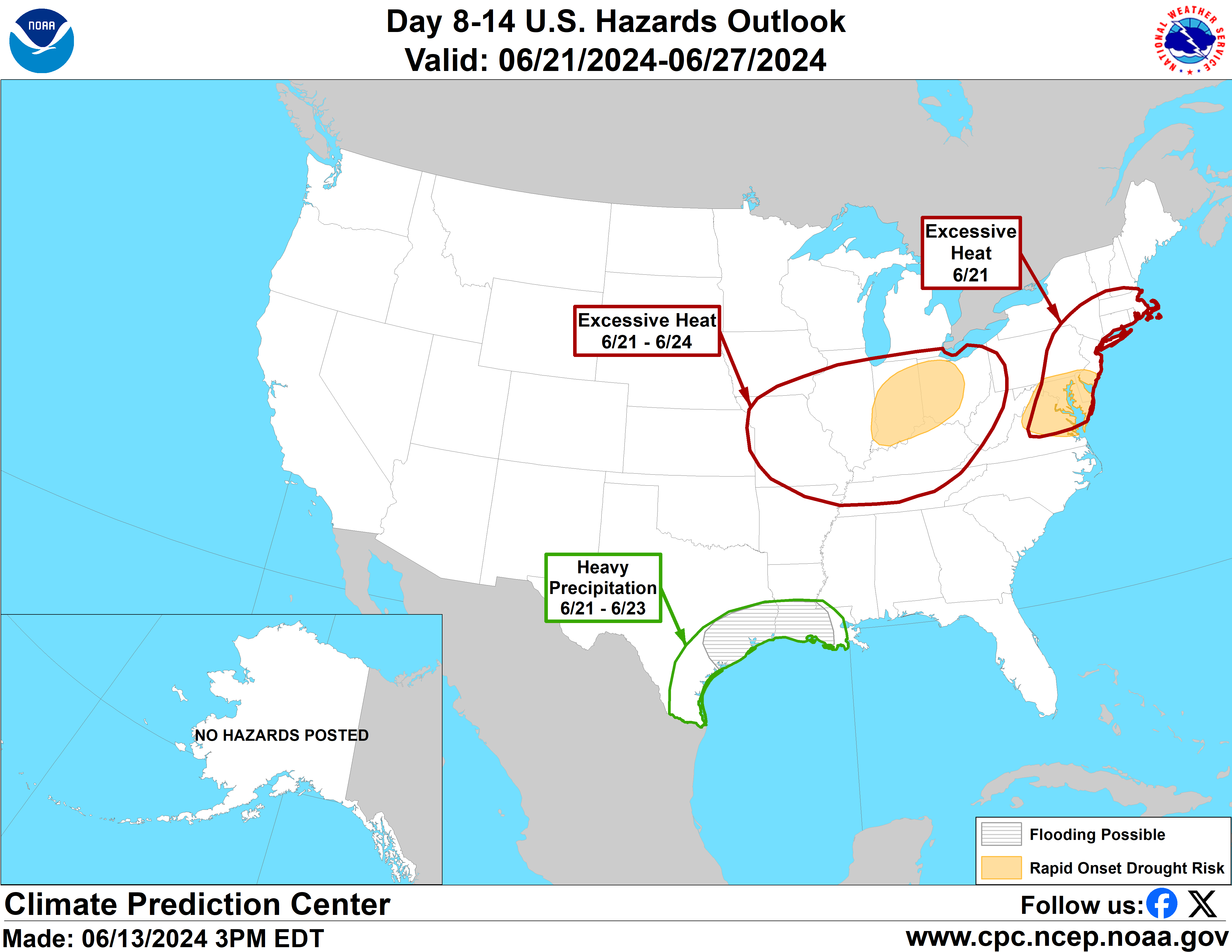
FLASH DROUGHT COMING TO THE ECB later this month AS I FEARED the last week+ and the NWS is picking up on.
https://www.cpc.ncep.noaa.gov/products/predictions/threats/threats.php
Current soil moisture anomalies:
https://www.marketforum.com/forum/topic/83844/#83853
+++++++++++++
The good news is that the last model runs increase rain chances for the ECB late this month!
This was the total rain from the last 18z GEFS that just came out.
The Upper Midwest/Northwestern Cornbelt should see ROBUST rains.
1. Total week 1 rains-180 hours-pretty skimpy ECB with the 90 degree days-maybe 1 inch in the northern area?
2. Total 2 week rains-384 hours-improving chances during week 2! Most of the ECB will need rain then! The light blue is 2"+.

However, the European model, though adding a bit of rain too is DRIER, maybe just over 50% of the ECB rains.
This is NOT a good start to the growing season in the ECB and the rapidly building La Nina in the Pacific is favorable for a major heat ridge in parts of the Central and Eastern US this Summer.
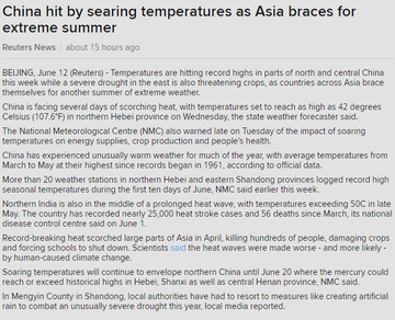
#China is undergoing an early summer heat wave with temperatures topping around 42C (~108F) on Wednesday in northern Hebei province. Severe drought in the east plus the heat threatens crops. Hebei and Northeast China are top grain growing regions.
Looking at the overall pattern and the rapid change in ENSO, flipping to La Nina, I'm very concerned about this upcoming heat ridge turning into a "dome of death" type entity that shuts down rains underneath its very expansive domain(warm air aloft capping-defeating rain making), along with HOT temperatures. This could have some staying power )-:
Last 0z European model in 2 weeks. The Euro is the driest in the ECB(to CCB) and thats the solution I'm leaning towards.
Big rains Upper Midwest, over the top of the heat ridge, high confidence.


Hopefully, things will change over the weekend.
It's the ECB that I've been most concerned about later this month AND BEYOND!
This is usually a low skill period but with the rapid onset of La Nina, gives me more confidence than usual. This is the first 2 weeks in July.
https://www.cpc.ncep.noaa.gov/products/predictions/WK34/

The next week:
NWS extended guidance has tons of rain. Grains are lower but the forecast is NOT bearish to me.
The ECB is very BULLISH......to me.
Bearish WI/MN/IA/NE/SD/ND
BUllish IL/IN/OH/MO.
1. 500 mb upper level heat ridge in 2 weeks-European Ensemble model from 12z-last one.
2. Total rains 2 weeks

Not much change in the weather overnight.
Bearish for just over half of the Cornbelt. Bullish for the other half, mainly the ECB.
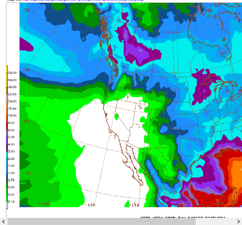
7 Day Total precipitation below:
http://www.wpc.ncep.noaa.govcdx /qpf/p168i.gif?1530796126
The market was trading some pretty bullish weather so far in June, so I guess it was all dialed in and the ECB often doesn't get top billing for weather markets.
Like my local farmer friends joke about every Spring, "If we can just get IA to have a drought, then prices will go up"
The weather is BEARISH for IA but the ECB is going to be in trouble.
I also think the NWS products/forecasts have too much rain in the ECB during week 2. The market acts like it believes those products.
Hopefully, I'm wrong because I live in the ECB along with many posters/readers here!!
Corn and beans were -2% in G/E but much of it only dropped to Fair category.
Still robust ratings over and compared to last year:
https://usda.library.cornell.edu/concern/publications/8336h188j
++++++++++
Still think the ECB, including IL may be in trouble with this weather pattern the next 2 weeks.
Not much change to the weather. Bullish ECB to IL. The European model is the most bullish!
Bearish elsewhere. The American model is the most bearish and is LESS bullish in the ECB.
Headed to Detroit to assist my 98 year old Dad shortly.
MetMike
When you say, Bullish ECB, you mean UNfavorable weather (dryness). Is not WCB approahing, if not already, WAY too wet for (optimum) crop development?
tic,
ar this time of year, it’s hard for rain to be bullish unless it’s pretty extreme With flooding.
Huge contrast in rain amounts for the ECB between the dry European model and the closer to average rains on the GFS/American model.
Big heat is a given on all the models.
12z EEnemble, total rains. Along and close to the Ohio River will start burning up with 90s/70s on most days the next 2 weeks
This weather data provider, TrueWeather is awesome. With the exception of the color bars they use for rain:the
1. Rains Euro-dry ECB
2. Rains GFS-Double the rains ECB
3. SAME Rains/data on the GFS using the NWS, NCEP site. Awesome on the colors!


MUCH BETTER colors below on this NWS product for the exact same data as the map immediately above.
WHAT a difference!

Overnight, the EE added some rain but is still BELOW average in the ECB. The much wetter, GFS stayed about the same to being a tad less wet.
Temperatures were NOT AS HOT in all the models.
This last 12z Canadian model(that comes out before the other models) has a stunningly bearish change(especially compared to what I've been thinking would happen).
Let me first provide the solution from 36 hours ago:
384h GZ 500 forecast valid on Jul 04, 2024 00 UTC

+++++++++++++++++++++++++++++++
Below is the last 12z solution just out, along with the individual solutions.
Instead of the La Nina forced, down stream huge dome that we see above. It has the NORTHERN STREAM, strongly digging deep upper level trough in the Hudson Bay, with an extension into the Midwest.
HOLY COW!
Included are the individual solutions. The majority agree with this NEW solution but its still 2+ weeks out, so stay tuned. This is NOT what i was expecting but it shows how unseen or unmeasured features in the atmosphere today, can grow into a completely different pattern in 2 weeks!!
With the teleconnecting upper level ridge in Western North America, especially in Northwest Canada, this is a very reasonable solution.
Those 2 features establish what we call a "couplet" that reinforce each other's existence. If the prevailing air flow is going strongly in 1 direction, let's say northward, in Western Canada, then an equal and opposite amount of air must be going southward someplace to maintain the balance, southward/downstream in Central Canada. The spacing between the opposite features that accomplish this always matters too.
384h GZ 500 forecast valid on Jul 06, 2024 12 UTC


+++++++++++++=
This is just 1 solution and it could change!
The Canadian model last night DID change drastically and looks more like the runs earlier this week NOT the one from Thursday morning!
https://weather.gc.ca/ensemble/charts_e.html?Hour=384&Day=0&RunTime=00&Type=gz

One of the biggest problems has been TOO MUCH rain in the Upper Midwest.
This is the rain from the last week
https://www.wunderground.com/maps/precipitation/weekly
Rains forecast for the next week:
7 Day Total precipitation below:
http://www.wpc.ncep.noaa.govcdx /qpf/p168i.gif?1530796126
Total rains from the GFS going out 2 weeks. The European model has half this amount of rain in the Ohio Valley which is what i think too.

Looks like this ring of fire pattern will continue with storm clusters tracking farther southeast than recently when the heat dome shifts farther southwest. This last forecast of the 6z GFS below for early July is a big change with northwest flow into the Midwest, instead of ring of fire action. This would help the Upper Midwest dry out.

Starting to look like this here in Indiana
Karen Braun
A week-plus of dry weather can quickly turn #corn from pretty to ugly, esp. on sandier soils like this field in southeast Illinois. Is this a disaster? No. Is this highly unusual? Also no, but it's stressful for a producer to see, esp. with another dry (and now hot) week ahead.
·
26.4K Views
Yes, exactly right and why Ive been forecasting a flash drought d eloping in the ECB back to IL!
Still with Dad in Detroit for another 4 days, so less posting as usual.
dome of death coming to parts of the US in July )-:
high confidence
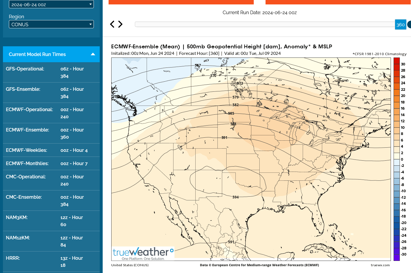
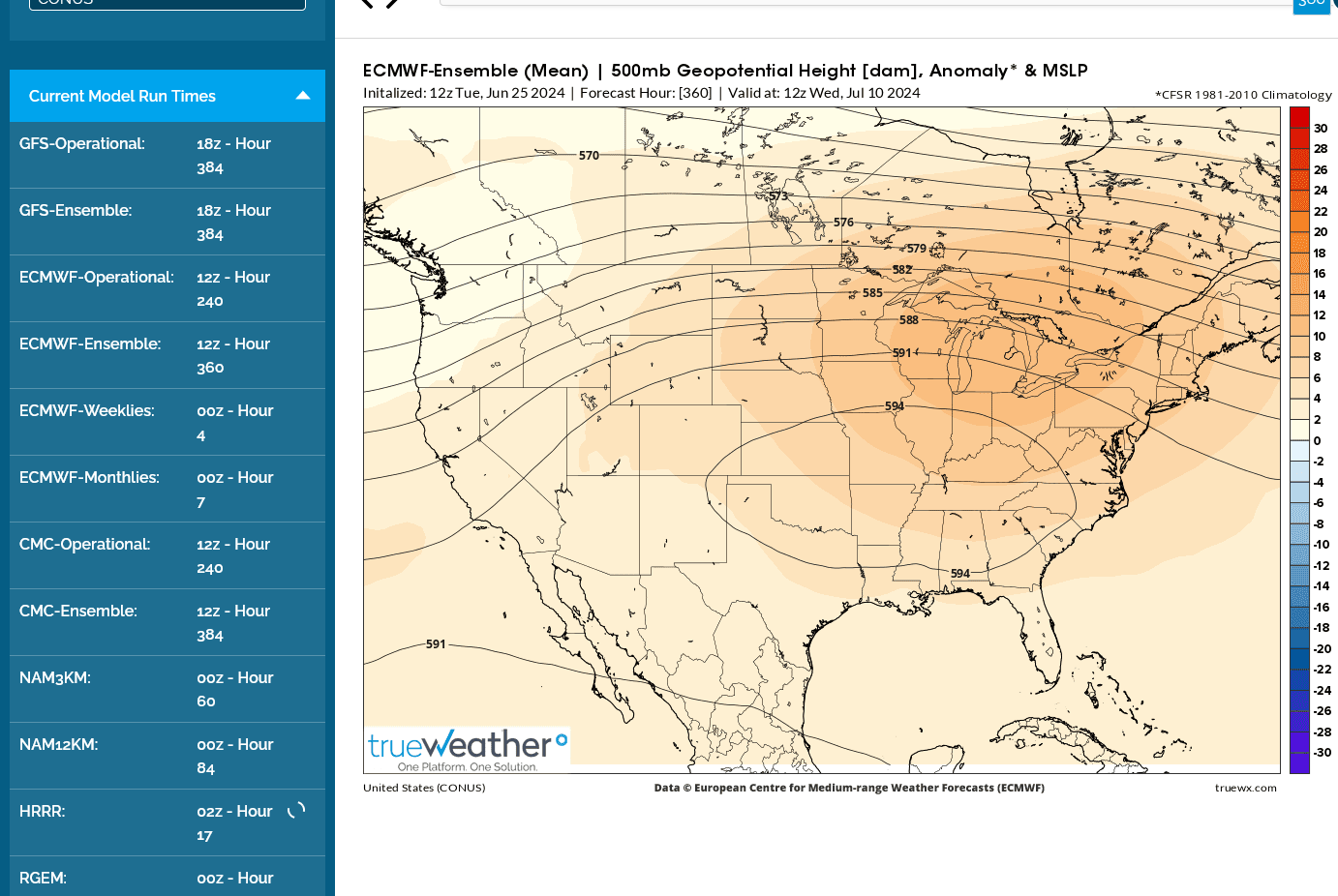
This was the last 0z 500 mb solution to start the 2nd week in July on the European model.
Areas under the 594 decameter height contour will have rain defeating warm air aloft and little hope for any rain if this verifies, along with 100 degree heat, drying out soils even faster, creating the flash drought.
Even areas along the periphery of the dome of death will struggle to generate a rain because the atmosphere will be CAPPED by the warm air aloft.
However, getting up towards the 591 dm contour, we should see increasing "ring of fire" activity. Hopefully
1 or 2 of the storm clusters can spread southeast from a low level jet stream with hot/humid air that the breaks thru the cap and tracks into the flash drought areas.
Anybody familiar with upper level weather maps knows that this is pretty ominous in the month of July.
Even in areas with decent rains around the periphery of the dome will see very warm temperatures that, if sustained after pollination into August WILL cause heat fill and accelerated growing degree days for corn that WILL substantially reduce yields because the reduced time to maturity is also reduced time for the plants to send energy/sugars to kernels that end up small instead of plump.
2010 is looking like a potential analog year with this pattern )-:
HeatFill for Corn
Started by metmike - July 14, 2023, 2:47 p.m.
Look what the last 6z GEFS did a few hours ago.
NORTHWEST FLOW!
This amount of rain down to the Ohio River is insane(almost 3 inches) considering the European model solution.
I hope THIS ONE is right for us living in that area!
I was getting ready to call my wife to tell her how to turn on our irrigation system this morning(because I forgot yesterday evening) but it looks like we could have just received close to an inch of wondrous rain that was extremely needed after 3 weeks of no rain +heat.
Let me know if anybody else got rain, looks like mcfarm might have but missed the best amounts to his north.
I just wish I was there to be in it!
The night before leaving for Detroit, we had some scattered t-showers that were blessing our area. 1 shower was getting real close to us and I couldn't leave for the gym until after it passed. Looking in the rain gauge to see how much fell after getting back is never enough.
There is just something about this that probably only producers can understand after a dry spell.
It also taps into my profound appreciation of the meteorological appreciation for the miracle of what causes rain and the fact that life on this planet is extremely dependent on H2O!
I just can't help but be outside on the front porch, then the back porch and sometimes stand out in it, especially running out to the rain gauge, getting soaking wet, to check on how much fell, even if I just checked 10 minutes earlier!
Again, this mainly happens during an extreme dry spell similar to this one, when the appreciation of benefits is greatly amplified.
This made my day!
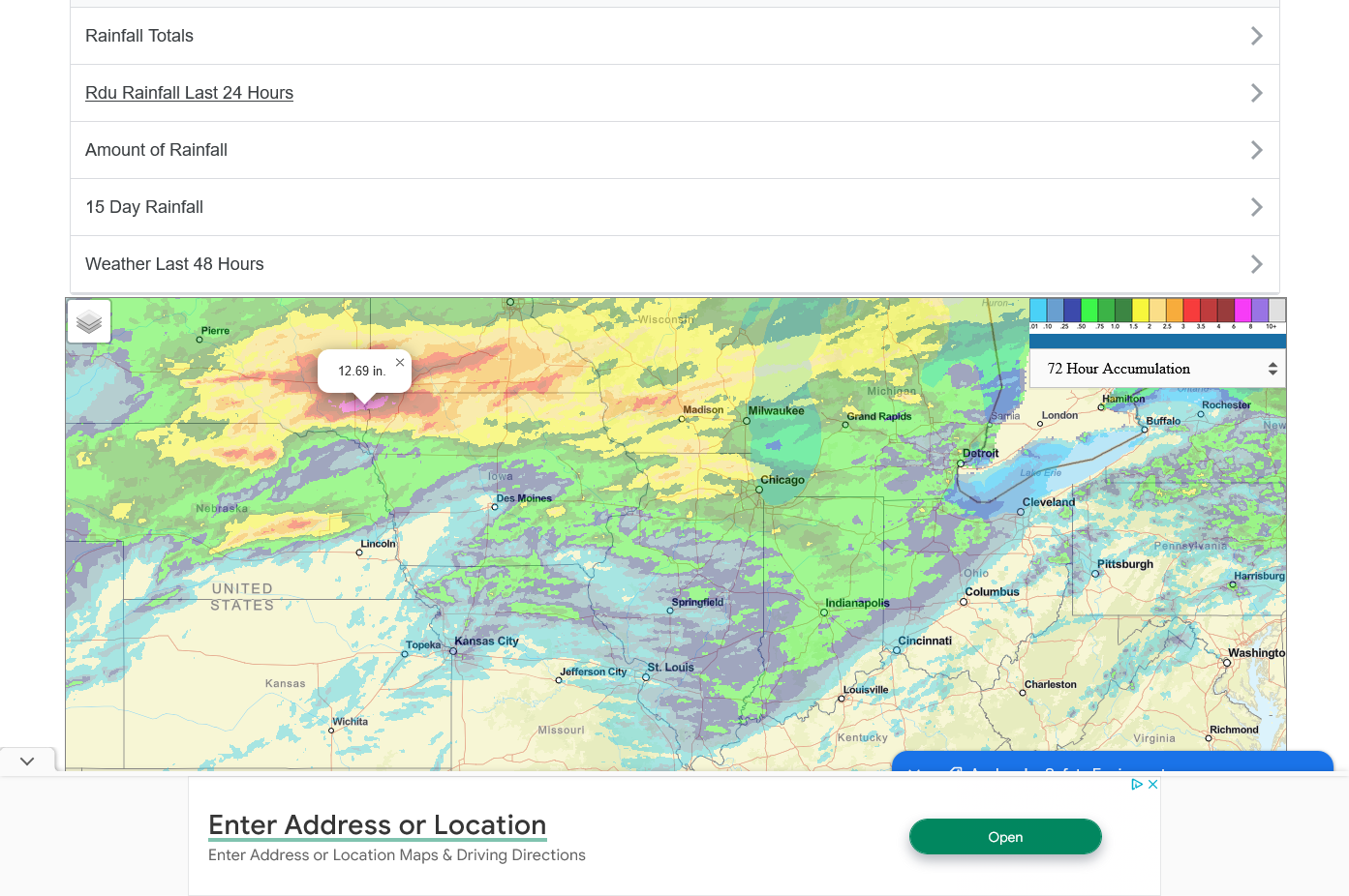
https://www.iweathernet.com/total-rainfall-map-24-hours-to-72-hours
++++++++++++
Rainfall the last 72 hours.
Sorry you barely missed, cutworm )-:
It especially hurts when a rain event completely falls apart at your doorstep.
https://www.iweathernet.com/total-rainfall-map-24-hours-to-72-hours
FLASH DROUGHT DEVELOPING IN THE EASTERN AND CENTRAL CORNBELT!
The week 2 forecast is very uncertain. Generally speaking most of the guidance has backed up the for sure DOME to the southwest compared to last week. Location, location, location matters the most.
1. The first solution below is the BEARISH GEFS which has the Midwest in northwest flow. This solution has been there for several runs.
2. The 2nd one is the most bullish, Canadian model.
3. European model. In between
4. Total rains on bearish GEFS. Looks much improved for the ECB, with ring of fire perturbations tracking in active northwest flow. Let's root for this one!

+++++++++++++++=
Just a guess on market action today.
1. Corn is weaker because northwest flow is cooler and means LESS heat fill/better pollination. Corn not hurt as much from these excessive rains in the Upper Midwest.
2. Beans "don't like wet feet" Crop ratings may drop this afternoon in the excessively wet areas.
Crop ratings should drop this afternoon. Because of:
1. Too much rain in the Upper Midwest
2. Flash drought/heat in the Central and Eastern cornbelt. Maybe just a big drop out of G/E but there will be an increase in the P/VP.
Regardless of that, the market is much more focused on THE FORECAST/FUTURE because the crop condition ALREADY HAPPENED.
Still in Detroit with my 98 year old dad!
The grains are reacting to a shift of the heavy rains even farther southeast with this ring of fire pattern that features perturbations coming around the periphery of the rain suppressing heat dome.
The shift would take heavy rains into the flash drought areas that need rain the most right now.
In addition, we have a big rain event in progress that is encroaching on some of the driest areas(more rain than expected):
https://www.marketforum.com/forum/topic/83844/
++++++++++++++++++++++
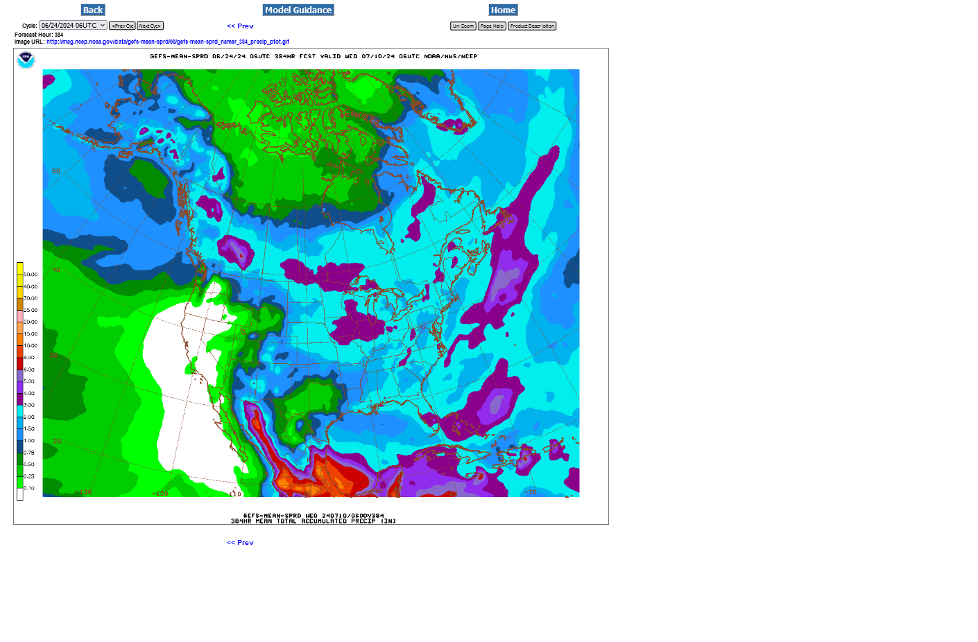
This was the 360 hour(15 days) location of the "dome of death" on the last 0z runs of the:
1. European model
2. Canadian model
3. GEFS model.........has done the best the past week!
4. Total rains on extremely bearish GEFS model(others have LESS rain in the driest spots). This is MUCH different than I was expecting/forecasting earlier this month and I'm thrilled to be wrong!


The light blue shade is 2"+. The outside purple area above is 3"+. Inside of that is the 4" contour for total rain the next 2 weeks. There will still be periods of high heat and surface soil moisture has been depleted in the ECB, so we'll need all of that rain to keep up.
If the heat continues into August, no matter how much rain falls, there will still be HEAT FILL for corn as described above.
HeatFill for Corn
Started by metmike - July 14, 2023, 2:47 p.m.
Almost forgot to post the crop condition from yesterday!! As expected.
U.S. #corn conditions drop 3 pts as expected but #soybeans decline 3 pts (2 were expected) and spring #wheat tumbles by 5 pts (1 was expected). Winter wheat harvest is 40% complete, and #cotton is in slightly better shape than last year.
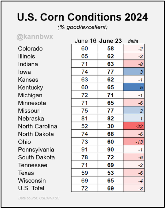
U.S. #corn conditions fell to 69% good/excellent as of Sunday versus 72% a week earlier. Hot & dry weather in the east took a toll in Ohio & Indiana, while overly wet conditions were problematic for the Upper Midwest/Plains.
Similar to corn, Indiana, Ohio & North Carolina led the 3 point decline in conditions for #soybeans this week, now at 67% good/excellent.
Funds are very bearish for the time of year on U.S. grains and oilseeds. Net selling in June 2024 is reminiscent of only June 2018 (trade war). Either we go into a (major or minor) U.S. weather scare from here or.... not? And what would the latter scenario look like?
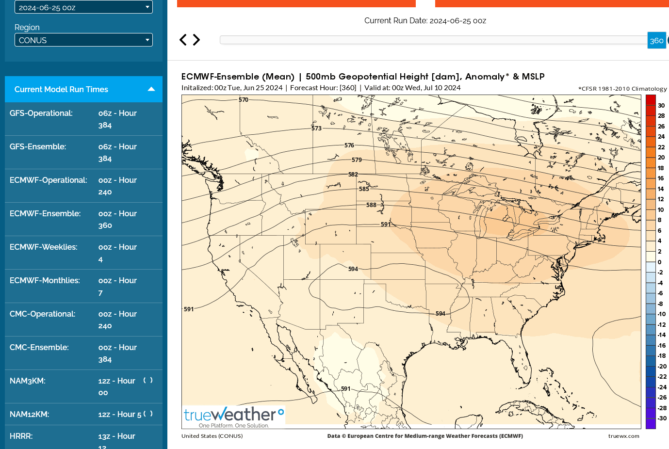
The last 12z european, 360 hour solution is looking more like I've been expecting.
There WILL BE a huge dome somewhere in the eastern 2/3rds of the country. The south is favored right now but this map also threatens the Southern Midwest, especially after the first few days in July.
Maps overnight were LESS bullish with the dome in the S.Midwest.
In fact, the last 6z GEFS was THE WETTEST YET! 2 week rains below:
Light blue=2+ inches
Purple = 3+ inches in some some of the driest spots.........WOW!

that's nice map, pretty colors and all. But most every rain goes around and leaves us dry. But sometimes like today we get 2 tenths those colors do not help much. We are up against it and instead of a prediction we need a soaker type rain.
that's nice map, pretty colors and all. But most every rain goes around and leaves us dry. But sometimes like today we get 2 tenths those colors do not help much. We are up against it and instead of a prediction we need a soaker type rain.
received .07 in rain today. was forecast for 1/2 in. not good.
Sorry that you guys missed the best rains.
We got over an inch here in southwest IN since Sunday Morning.
This month, I've been VERY concerned about a flash drought in the ECB but the guidance this week, along with the NWS keep insisting a ton of rain is on the way.
The previous 2 days, the GEFS has insisted on 3+ inches the next 2 weeks.
Overnight, it's backed off on those amounts which actually makes more sense to me(though some has fallen).
The darker blues are LESS than 2 inches of rain. With heat in this pattern, most of those areas will see significant drying.
Sadly, this solution makes more sense to me vs the wet ones earlier this week.

We DID develop a flash drought in some areas of the ECB back to IL and you guys are experiencing that )-:
https://www.marketforum.com/forum/topic/83844/#83853
Recent rains:
The last 12z GEFS took out a bit more rain:

I WAS OUT & ABOUT, YESTERDAY... A LOT OF THE CORN IN THE MORE SANDY SOILS, IS WAIST HIGH & THE BEANS ARE 6-8 INCHES. I MY AREA OF PURE CLAY... MOST OF THE CORN LOOKS WONDERFUL & ABOUT 1/2 OF IT JUST MIGHT MAKE IT KNEE-HIGH, BY THE 4TH OF JULY. WE GOT LESS THAN AN INCH OF RAIN AFTER THAT AWFUL HEAT WAVE.
RAIN COMIN' THROUGH FOR ALL DAY & NIGHT, ON SATURDAY.
The rain forecast has not been validating in my area.
In NE Ohio it was getting kind of dry but then it rained hard all day Wednesday. I was out in the farming area yesterday (Thursday) and the corn is mostly waist high and looks good.
some of my early corn is tasseling and in the afternoon, it is curling.
Almost all the corn in my county is curling in the afternoon.
totally missed a big rain this am. Took a crop drive and saw some of the 3 crops out there. 1 is real good. 1 is average. and 1 should of been torn up and replanted. Late this afternnoon another rain came thru the area and bingo we got near a 1/2 inch. Thank goodness is all you can say when you get rain that you badly need.
NW OHIO.... WE MISSED ALL OF THE RAIN & GOT 1/3". IT WAS TO RAIN / STORM ALL NIGHT LAST NIGHT & ALL DAY TODAY, THRU 6:00 PM.
NOW, THEY'RE CALLIN' FOR 1-2 INCHES, TONIGHT.
70s & 80s FOR ALL NEXT WEEK WITH A 1/2" OF RAIN. EDIT: WE GOT NO RAIN
AT PRESENT, WE'RE AT 83 DEGREES WITH A REAL FEEL OF 93 / DEW 77 / HUM 83
Received between 6/10 to 11/2 inches on my farms. Highly variable but greatly apricated. Might be to late for the hot spots.
NOT AS HOT forecast compared to last week!
https://www.marketforum.com/forum/topic/104476/#105289
Total 384 hour rains from the 6z GEFS:
Less heat=better pollinating and early filling weather for corn.
So corn is weaker today vs beans.
U.S. #corn conditions fell 2 pts to 67% good/excellent as of Sunday, still the week's best since 2020. There were some largely offsetting weekly changes in the major states, though the southeast drought impacts are really showing up (see North Carolina).
Conditions for U.S. #soybeans were unchanged on the week at 67% good/excellent, the week's best since 2020. Crop health slipped in some of the major western producers and in the south, but top producer Illinois jumped 5 points.
The weather has looked increasingly bearish with the dome moving AWAY from the Cornbelt.
The last 12z run of the European model below shows northwest flow with perturbations moving from nw to se on the backside of the upper level ridge that has backed up to the Rockies to W.Plains.
Yellow shades show vorticity/spin in the atmosphere.
Higher vorticity means move lift for making clouds/rain when the air rises and moisture condenses out as it cools since cooler air has less ability to hold water vapor.

+++++++++++++++++++++++++++++++++++++++=
3+ inches the next 2 weeks in much of the Cornbelt if the last GEFS run is correct.

Overnight GEFS added more rain:
Is this too much in the Upper Midwest areas that had the flooding?
The ECB would love to see 3+ inches.
The threat for the heat ridge to move into the Midwest the next 2 weeks is very low right now.
Remnants of Beryl targeting dry area of Il and ECB with big/welcome and bearish rains is crushing beans. See the Beryl thread and weather thread for the latest rain updates.
Both corn and beans were +1%
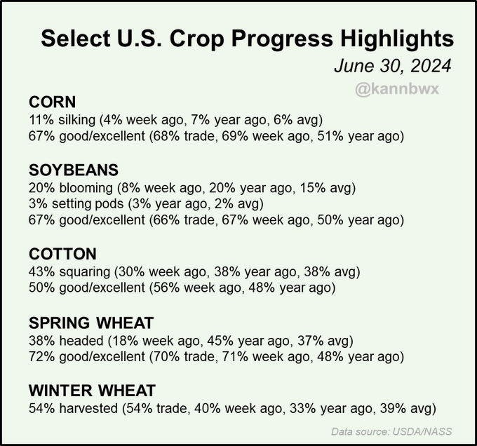
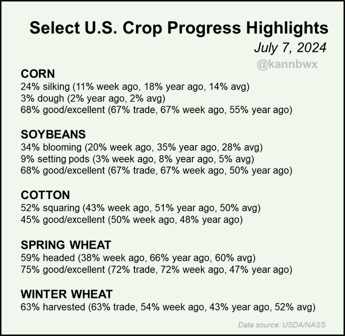
Conditions for U.S. #corn and #soybeans improved 1 pt on the week (unch was expected), though spring #wheat conditions jumped 3 pts (unch was expected). #Cotton conditions have plunged 11 pts in two weeks. Winter wheat harvest is 63% complete, ahead of average pace.
+++++++++++++++
U.S. #corn conditions increased 1 pt on the week, but there were many improvements in top growers, including I-states, Ohio and Kansas. North Carolina's terrible luck continues as conditions slide to just 12% good/excellent (was 81% on June 2).
Conditions for #soybeans also rose 1 pt this week and it was a mixture of improvements and declines at the state level. Two-thirds of beans in top producer Illinois are considered in good or excellent shape.
Grains are in a really good spot for this time of year.
1.35 inches in my rain gauge from the wonderful Tuesday rains!