++++++++++++
This has been expected all year. More shortly.
Previous threads:
Introducing “RONI”, index that better reflects ENSO in warming world
Started by WxFollower - May 22, 2024, 12:41 p.m.
https://www.marketforum.com/forum/topic/104150/
++++++++++++++
Dying El Nino! 4-10-24
Started by metmike - April 10, 2024, 10:30 p.m.
https://www.marketforum.com/forum/topic/103079/
Forecasters on Thursday put 65% odds on #LaNina's establishment between July-Sept, and the odds are greater than 80% that La Nina will be in place at the end of 2024/start of 2025.
La Nina's are usually NOT good news for Summer crop weather in the Midwest.
Also NOT good news for people living in Hurricane Alley.
Discussion on this Summer's weather:
https://www.marketforum.com/forum/topic/101854/#102658
https://www.marketforum.com/forum/topic/101854/#101858
https://www.marketforum.com/forum/topic/101854/#101859
https://www.marketforum.com/forum/topic/101854/#101860

https://www.cpc.ncep.noaa.gov/products/precip/CWlink/ENSO/enso.anal.shtml
La Nina's are usually NOT good news for Summer crop weather in the Midwest.
Discussion on this Summer's weather:
https://www.marketforum.com/forum/topic/101854/#102658
https://www.marketforum.com/forum/topic/101854/#101858
https://www.marketforum.com/forum/topic/101854/#101859
https://www.marketforum.com/forum/topic/101854/#101860
https://www.cpc.ncep.noaa.gov/products/precip/CWlink/ENSO/enso.anal.shtml
+++++++++++++++++
Also NOT good news for people living in Hurricane Alley.
The stronger the La Nina, the less wind shear there tends to be in the Atlantic and this creates a more favorable environment for hurricanes there.
https://www.daculaweather.com/4_nino_graphs.php

And we have incredibly warm waters in the tropical Atlantic/GOM right now:
https://www.ospo.noaa.gov/Products/ocean/sst/anomaly/

Last hurricane season, the El Nino was a hurricane suppressing force. However, very warm tropical Atlantic water temperatures caused an active hurricane season, despite that.
In 2024, with those warm tropical Atlantic temperatures expected to continue AND a potential La Nina, my initial hurricane forecast is for a very active season!
https://en.wikipedia.org/wiki/2023_Atlantic_hurricane_season
These were most of our posts last hurricane season.
Thanks for all the contributions, especially by WxFollower and Jean getting her feet wet, having fun with the hurricane forecasting!
2023 hurricane season prediction
16 responses |
Started by metmike - May 25, 2023, 7:10 p.m.
https://www.marketforum.com/forum/topic/95535/
Mktfrm 2023 Atlantic Hurricane Season Forecast Contest: deadline *6/4/23*
36 responses |
Started by WxFollower - May 31, 2023, 4:07 p.m.
https://www.marketforum.com/forum/topic/95746/
Here Comes STS Don out in middle of nowhere
15 responses |
Started by WxFollower - July 14, 2023, 1:45 a.m.
https://www.marketforum.com/forum/topic/97220/
2023 Hurricane season status
21 responses |
Started by metmike - Aug. 7, 2023, 11:26 a.m.
https://www.marketforum.com/forum/topic/97993/
TD10/Future Idalia threat to W Florida
28 responses |
Started by WxFollower - Aug. 27, 2023, 3:18 a.m.
https://www.marketforum.com/forum/topic/98571/
TW African coast 9/1: all models develop/could be long tracker; now is Lee
63 responses |
Started by WxFollower - Sept. 1, 2023, 6:16 p.m.
https://www.marketforum.com/forum/topic/98675/
Lee significantly cooled SSTs well ahead of center
6 responses |
Started by WxFollower - Sept. 18, 2023, 8:21 p.m.
https://www.marketforum.com/forum/topic/99073/
Hurricane Tammy +more
23 responses |
Started by metmike - Oct. 22, 2023, 1:09 p.m.
https://www.marketforum.com/forum/topic/99881/
Thanks, Mike.
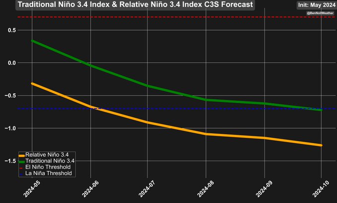
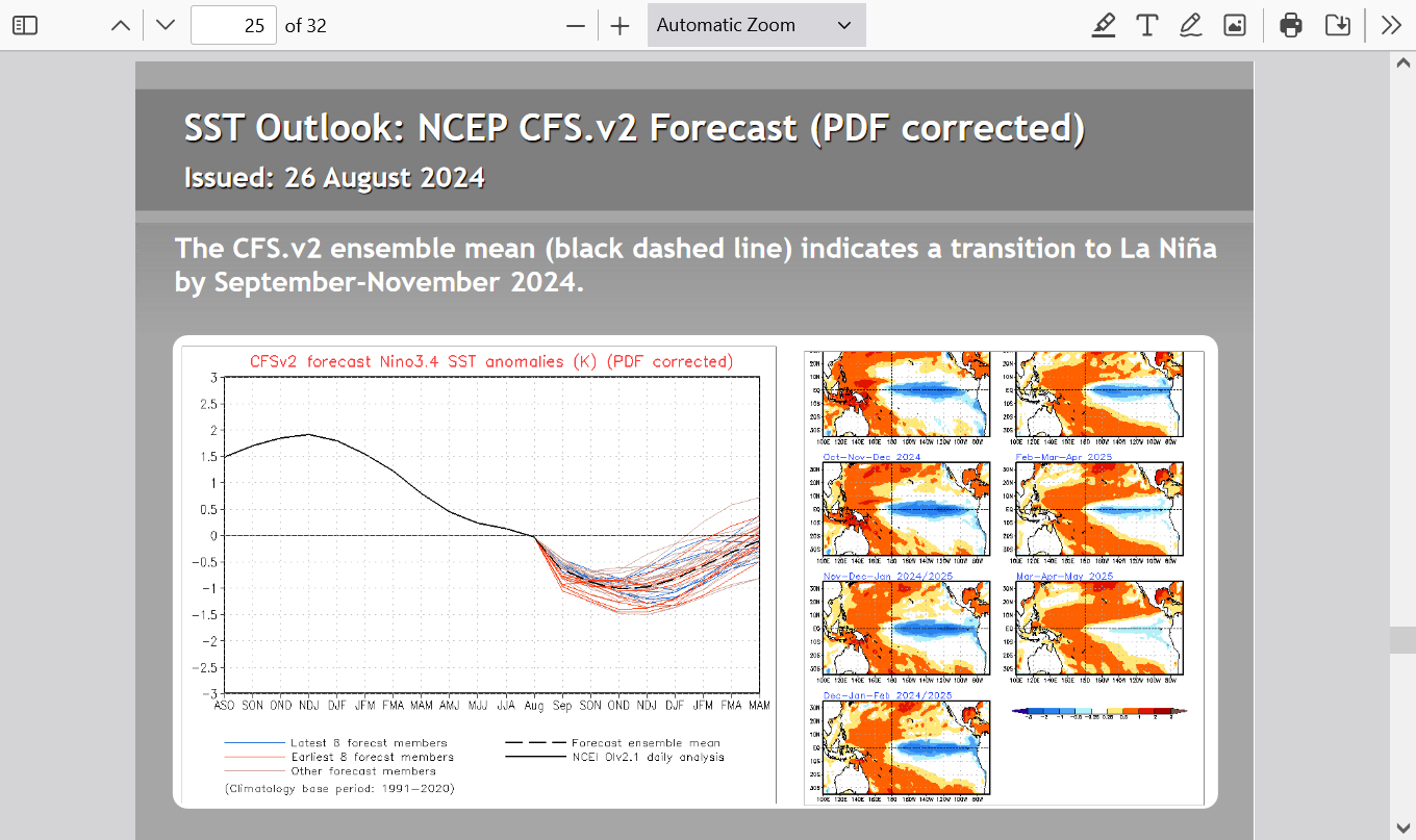
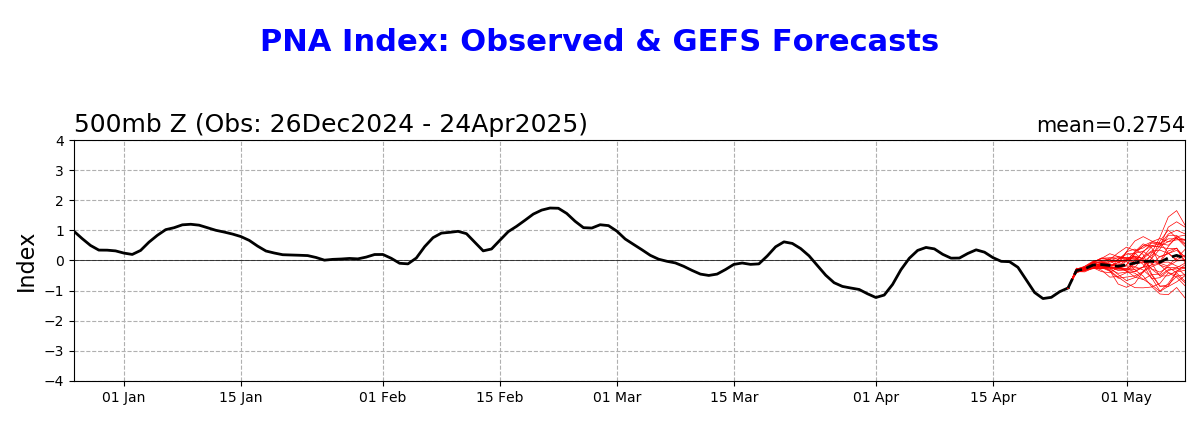
Based strictly on RONI, which modifies ONI (shown by green line in image below) by taking into account GW of the worldwide tropical oceans overall, we’ve already likely just started La Niña (cooler than -0.5C): see yellow-orange line below:
https://x.com/BenNollWeather/status/1793235394219434190/photo/1
YES!
Also, an OFFICIAL La Nina is based on a 3 month average.
The reality is that's a LAGGING indicator because we cross the La Nina threshold very early in those 3 months.
Give you an example with these numbers.
1-2-3-4-5-6-7-8-9-10-11-12.
If we were progressively advancing from 1 to 12, when does the 3 period/number average get above 6?
Not until after we get above 7 (5+6+7/3=6)
The reality, the instantaneous metric measurement got above 6 when we hit 6.1 not 7.1.
So the instantaneous measurement shows us getting above 6, exactly 1 period EARLIER than the 3 number period....in this example with rapid progression in 1 direction.
Same thing with La Nina.
The instantaneous measurement of ENSO temps will ALWAYS go THRU the La Nina threshold first but it will take time for the 3 month average to catch up.
The atmosphere isn't waiting for NOAA to tell it that we have a NOAA defined La Nina.
It starts responding to La Nina.......when the instantaneous/LAST temperature reading crosses into the La Nina threshold.
And there is some relativity here.
The faster its changing, the quicker the reaction to the atmosphere.
And the atmosphere doesn't usually respond a certain way, like a switch being flipped on when we suddenly cross the La Nina threshold. Usually, the impact TRANSITIONS to the new regime.........but not always.
At certain times of year, it really can be a sudden, abrupt shift because it changes the location of the LARGE SCALE WEATHER FEATURES dominating downstream.
For instance, it could shift the position of an upper level high eastward by XXX miles downstream, resulting in some places going from the back side of an upper level trough..... to the front side an upper level high that was to the west previously but has shifted east by XXX miles. Then, the center of the high could shift in as it builds stronger with the strengthening La Nina.
Tthat shift might only be reinforced/amplified if the ocean temperature change causing it continues to change in that direction.
This is what is concerning me right now about this heat ridge coming in.
If it's a product of the rapidly cooling tropical Pacific, more cooling in the ENSO region will only make that heat ridge more tenacious.
But there are other forces that can deflect the La Nina impact to the south, north, east or west.
Teleconnections with features/temps in the Atlantic Ocean could play a huge role.
Many believe the Atlantic Ocean teleconnections/indices/temperatures in the 1930s are what played the key role in the Dust Bowl during that decade.
Today, we know the exact same thing would be blamed on the climate crisis!
+++++++++++++
Ironically, real climate change, much of it caused by humans from global warming and photosynthesis greening this same region IS helping to PROTECT US FROM ANOTHER DUST BOWL!
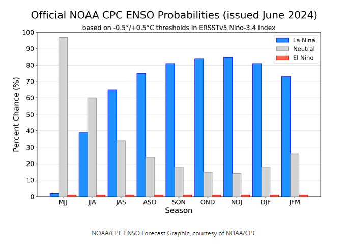
The expected La NIna has been a bit SLOWER to develop than expected this Summer.
As a result, the dry weather in the Cornbelt which La Nina's typically bring has been delayed towards the end of our Summer, AFTER the C and S crops have been able to be ALMOST made.
Yields will likely drop a bit in the next USDA report, especially for beans because of this dry finish.
But make no mistake, the La Nina is still coming and should dominate this Winter!
ENSO: Recent Evolution,
Current Status and Predictions
Why La Niña Could Mean a COLDER Start to Winter 2024-25
https://www.youtube.com/watch?v=yosFFkSTsLc
https://www.youtube.com/watch?v=5LDmdCqBOps
++++++++++++++++++++++
https://www.weather.gov/iwx/la_nina

+++++++++++++++++++++++


Historically, a strong blocking high-pressure system in the North Pacific is the most typical effect of a cold ENSO phase (La Nina). That usually redirects the polar jet stream down over the northern United States.
The image below shows the average pressure pattern during the last few La Nina winters. We can see a strong high-pressure system in the North Pacific and a low-pressure area over Canada and the northern United States. Images by NOAA Physical Sciences Laboratory (PSL).
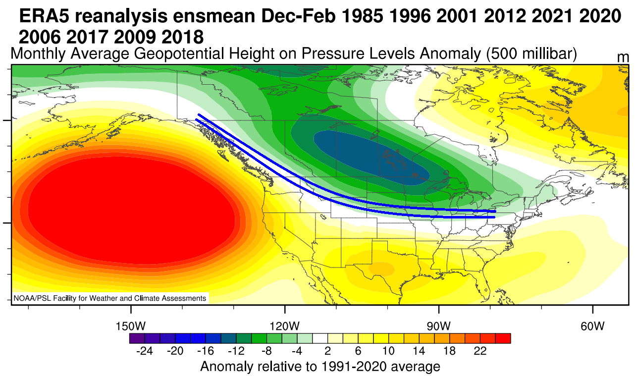
The circulation of the strong high-pressure system promotes the development of a low-pressure region over Alaska and western Canada. It curves the jet stream downwards between the two pressure systems, marked by the blue lines.
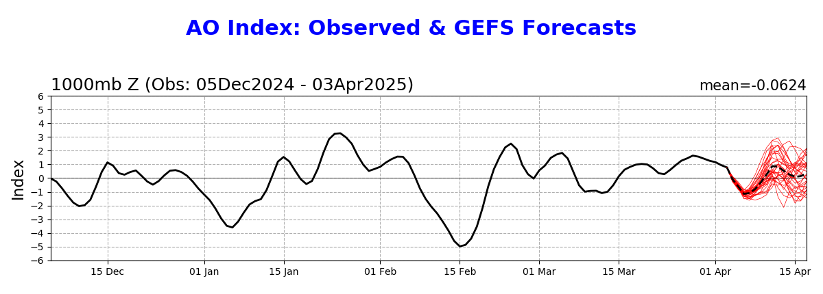
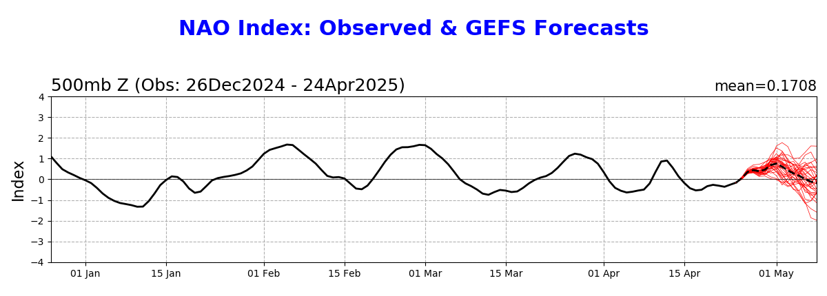
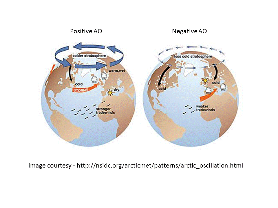
You should note that we show these indices, updated every morning on our weather page. Here's what they mean/why they are important:
https://www.marketforum.com/forum/topic/83844/#83856
Arctic Oscillation Index, North Atlantic Oscillation Index, Pacific North American Index.
https://www.cpc.ncep.noaa.gov/products/precip/CWlink/daily_ao_index/ao.shtml
https://www.cpc.ncep.noaa.gov/products/precip/CWlink/pna/nao.shtml
https://www.cpc.ncep.noaa.gov/products/precip/CWlink/pna/pna.shtml
+++++++++++++++
https://www.weather.gov/iwx/la_nina


All the more comprehensive weather here:
https://www.marketforum.com/forum/topic/83844/
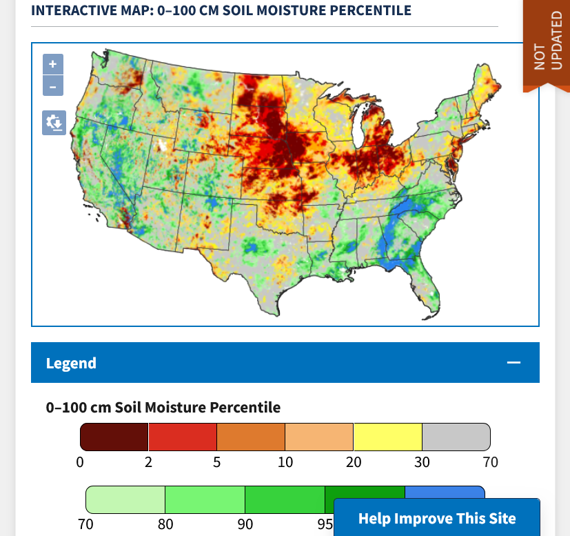
Note the drying trends in the Southern and Eastern cornbelt late in the growing season:
Re: Re: Re: Re: Re: Weather May 2022
Soilmoisture anomaly:
These maps sometimes take a day to catch up to incorporate the latest data(the bottom map is only updated once a week).
https://www.cpc.ncep.noaa.gov/products/Soilmst_Monitoring/US/Soilmst/Soilmst.shtml#
![]()


ENSO: Recent Evolution,
Current Status and Predictions
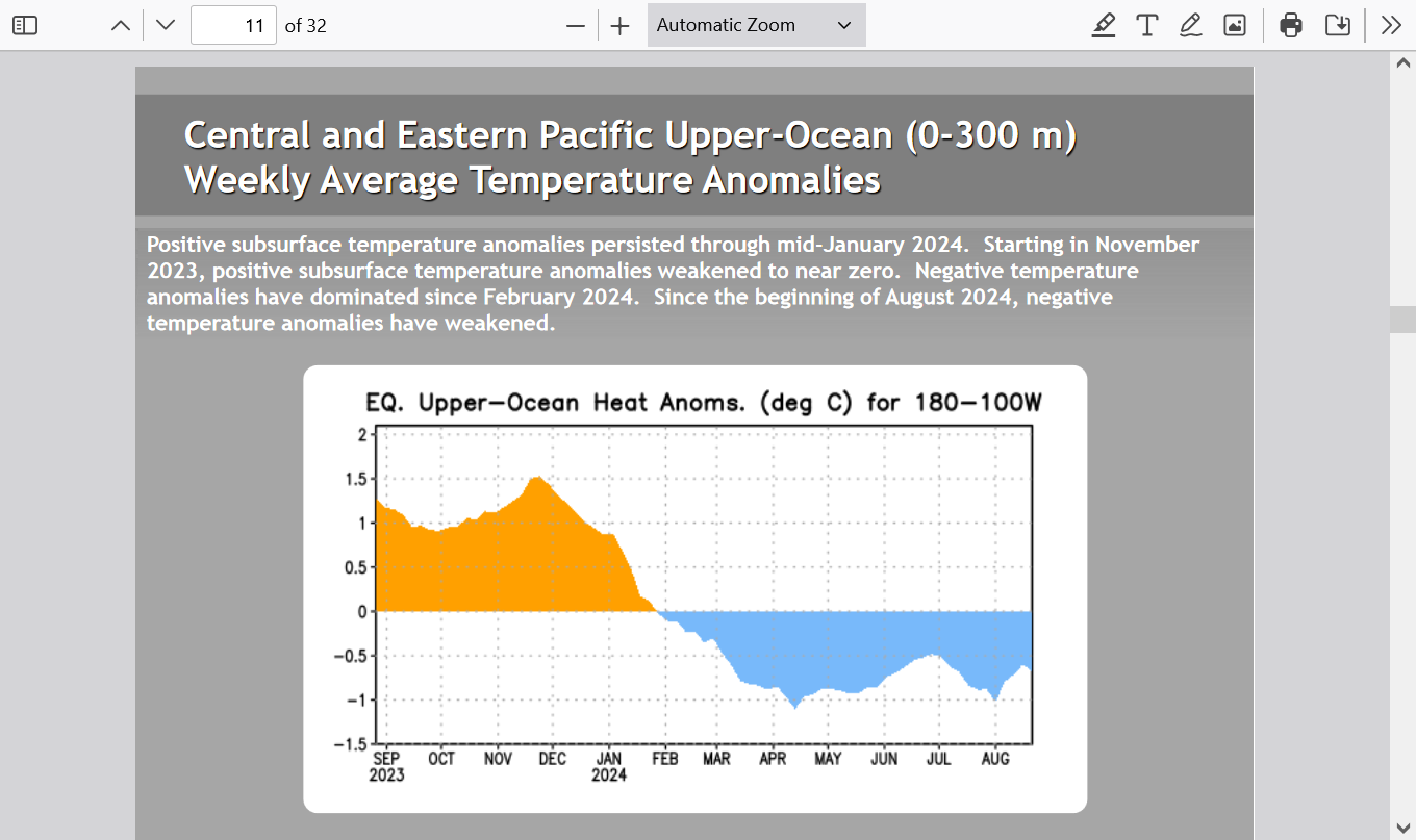
The atmosphere is already in La Nina mode!
Just updated:
To repeat: NOAAs official definition of a La Nina is a LAGGING INDICATOR(3 month average). As a result, the ocean and atmosphere will be in a La Nina mode for a couple of months BEFORE NOAA announces: "Hey everybody, the cooling tropical Pacific water has suddenly crossed the threshold to meet our La Nina standard/definition"
The current cool water temp anomalies are right on the threshold for NOAA. The ocean/atmosphere crossed that threshold months ago when it started cooling.
This is what has caused the late growing season drought in the Midwest!!!!!!! Not the fake climate crisis!
https://www.drought.gov/data-maps-tools/nasa-sport-lis-soil-moisture-products
La Nina's are NATURAL oceanic phenomena that have been taking place for at least thousands of years. They happen periodically and when cooler water in the deep ocean is brought to the surface.
El Ninos are the complete opposite(warm water anomolies) and also NATURAL. The key area in the tropical Pacific that we use to determine this is known for its ability to have the biggest role on global weather patterns.
+++++++++
The only reason that the drought in the Southeastern 1/3rd of the US has been wiped out is because of the remnants of hurricanes coming up from the Gulf of Mexico. Fact is, the current La Nina in the atmosphere is VERY FAVORABLE for hurricanes just like these because it suppresses wind shear. Climate change ADDED around 7% moisture but the hurricanes were CAUSED BY NATURAL VARIABILITY, INCLUDING THE CURRENT LA NINA!
+++++++++++++++++
La Nina's suppress wind shear in the Atlantic basin, including the Gulf of Mexico and this NATURAL LA NINA has greatly assisted the GOM hurricanes to intensify rapidly.