Cotton conditions actually improved yesterday.......but not for long. The dome of death will be haunting cotton country this Summer )-:
https://usda.library.cornell.edu/concern/publications/8336h188j

BULLISH WEATHER FOR COTTON!
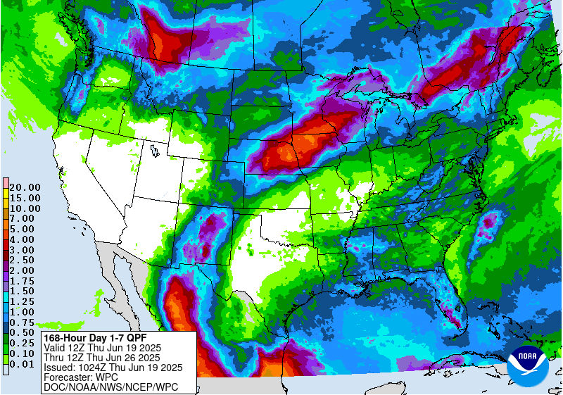
7 Day Total precipitation below:
http://www.wpc.ncep.noaa.govcdx /qpf/p168i.gif?1530796126

https://www.cpc.ncep.noaa.gov/products/predictions/814day/index.php


Front month cotton has been crashing lower from a high just above $1 at the end of February to the current price near 65c.
However, NEW CROP cotton is trading a completely different, supply side/weather dynamic because of the dome of death in July.
It bottomed on 6-17 at around 70c.
It's up 1.6c to 75c today. The limit is 3c, I believe. Each 1c = $500 for cotton.
So cotton is +$800/contract today, despite crop conditions showing an improvement yesterday.
This is the just out 12z Canadian model forecast for 500 mb, which is midway in the atmosphere(~1000 mb at the surface) for Jul 11th.
This corresponds to a height of between 15,000 feet in the Winter with cold dense air to almost 20,000 feet in a heat dome of Summer with very warm, less dense air.
The 594 decameter contour below is a heat dome!
It not only features heat at the surface, which will be flirting with 100 degrees this time but also warm air aloft which defeats rain making by capping the ability of hot/humid air just above the surfaceto rise as it cools aloft because.........it DOESN"T cool enough while rising. The cooling from the rising is what causes the moisture to condense out to clouds, which is the starting point for rain making.
Very warm air aloft STIFLES THIS PROCESS.
The exact location of this dome is uncertain but there is very high confidence of it living in the south, especially in Texas the #1 cotton producer by a very wide margin!
https://weather.gc.ca/ensemble/charts_e.html?Hour=384&Day=0&RunTime=12&Type=gz
384h GZ 500 forecast valid on Jul 11, 2024 12 UTC
https://oceannavigator.com/basics-of-the-500-millibar-chart/