Invest 95L well out in the MDR of the Atlantic is headed for the Lesser Antilles ~7/1. Most but not all models are developing this into TS Beryl by then. Some runs/ensemble members are even developing it into a hurricane before it reaches the W Caribbean.

Tropical Weather Outlook
NWS National Hurricane Center Miami FL
200 PM EDT Thu Jun 27 2024
2. Eastern Tropical Atlantic (AL95):
A tropical wave located several hundred miles west-southwest of the
Cabo Verde Islands continues to produce disorganized shower and
thunderstorm activity.  Environmental conditions are forecast to be
conducive, and development of this system is anticipated.  A
tropical depression or tropical storm is likely to form this weekend
several hundred miles east of the Windward Islands while the system
moves westward at 15 to 20 mph.  Interests in the Lesser Antilles
should monitor the progress of this system.
* Formation chance through 48 hours...medium...60 percent.
* Formation chance through 7 days...high...80 percent.
Thanks much, Larry!
Beryl is a hurricane and predicted to be a major hurricane in 48 hours and stay at that level for a couple days, then weakening to a minimal hurricane before hitting far southeast Mexico in around 5 days.
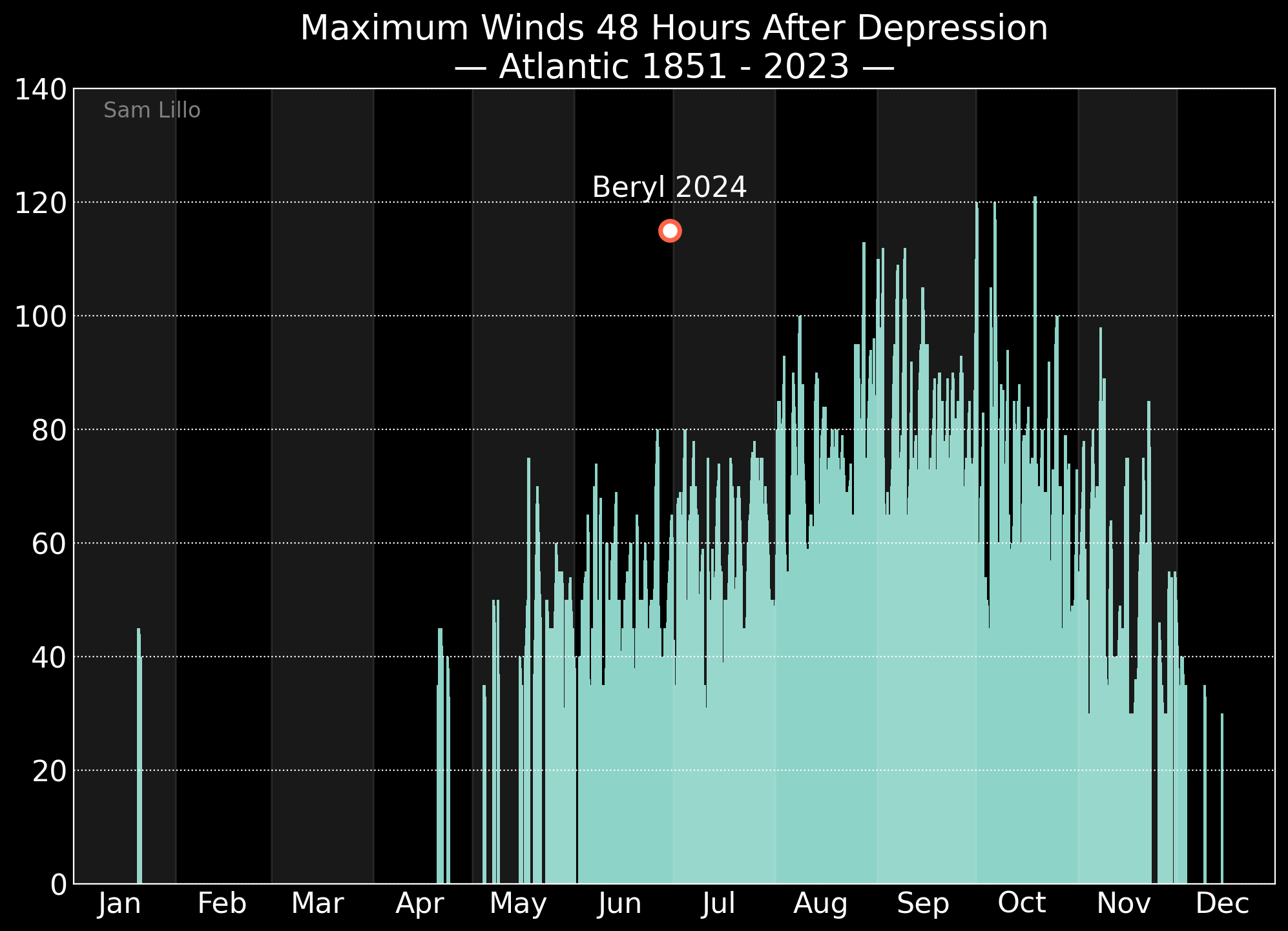
Some firsts with this storm, which is now a cat 4:
Hurricane Beryl has now shattered long-standing records for the Atlantic basin.
On Saturday, Beryl became the easternmost hurricane to ever develop during the month of June. Beryl formed further east than Elsa in 2021 and an unnamed hurricane that formed east of Trinidad and Tobago in 1933.
While rare, June hurricanes are possible, however they are typically found in the Western Caribbean or Gulf of Mexico, not east of the Lesser Antilles.
Beryl went on to become the strongest June hurricane on record for the Atlantic basin, beating Hurricane Audrey in 1957. Audrey had winds of 125 mph. It is now the earliest cat 4 on record.
Beryl strengthened more rapidly than just about any June storm on record.
Thanks a ton, Larry!
Still on vacation in Grant, Alabama!
https://www.nhc.noaa.gov/text/refresh/MIATCDAT2+shtml/010244.shtml?
https://www.nhc.noaa.gov/graphics_at2.shtml?start#contents

You’re welcome, Mike. Hope you’re having fun!
More on the very rapid strengthening. This image says it all:
WOW!
So glad that you shared that!
Thanks, Mike. This is unreal: 150 mph/950 mb landfall on Carriacou Island….on July 1st!! Historic. The only “good news” is that it has been moving at a pretty fast clip of 20 mph:
Hurricane Beryl Tropical Cyclone Update
NWS National Hurricane Center Miami FL       AL022024
1110 AM AST Mon Jul 1 2024

...EXTREMELY DANGEROUS CATEGORY 4 BERYL MAKES LANDFALL ON CARRIACOU
ISLAND...
...AIR FORCE RECONNAISSANCE AIRCRAFT FINDS BERYL STRONGER...

Satellite imagery and Barbados radar data indicate that the eye of
Beryl has made landfall on Carriacou Island at 1110 AM AST (1510
UTC). Data from an Air Force Reserve Hurricane Hunter aircraft
indicate that Beryl's maximum sustained winds have increased to 150
mph (240 km/h). The latest minimum central pressure estimated from
reconnaissance data is 950 mb (28.05 inches).


SUMMARY OF 1110 AM AST...1510 UTC...INFORMATION
-----------------------------------------------
LOCATION...12.5N 61.5W
ABOUT 0 MI...0 KM S OF CARRIACOU ISLAND
ABOUT 30 MI...50 KM NNE OF GRENADA
MAXIMUM SUSTAINED WINDS...150 MPH...240 KM/H
PRESENT MOVEMENT...WNW OR 285 DEGREES AT 20 MPH...31 KM/H
MINIMUM CENTRAL PRESSURE...950 MB...28.05 INCHES

$$
Forecaster Reinhart/Kelly/Cangialosi
Beryl is now a category five hurricane and is the earliest cat 5 on record, breaking the previous record earliest of Emily of 2005 by 15 days!
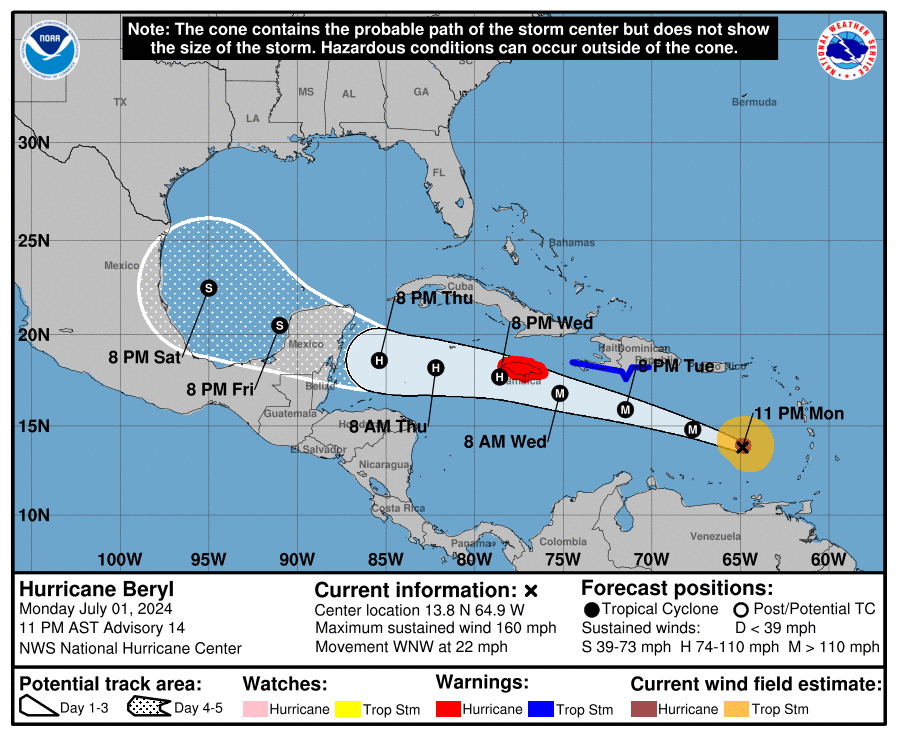
11:00 PM AST Mon Jul 1
Location: 13.8°N 64.9°W
Moving: WNW at 22 mph
Min pressure: 938 mb
Max sustained: 160 mph
Double the speed of a minimum hurricane!
https://www.nhc.noaa.gov/text/refresh/MIATCDAT2+shtml/020252.shtml?
https://www.nhc.noaa.gov/refresh/graphics_at2+shtml/025202.shtml?cone#contents

Thanks, Mike.
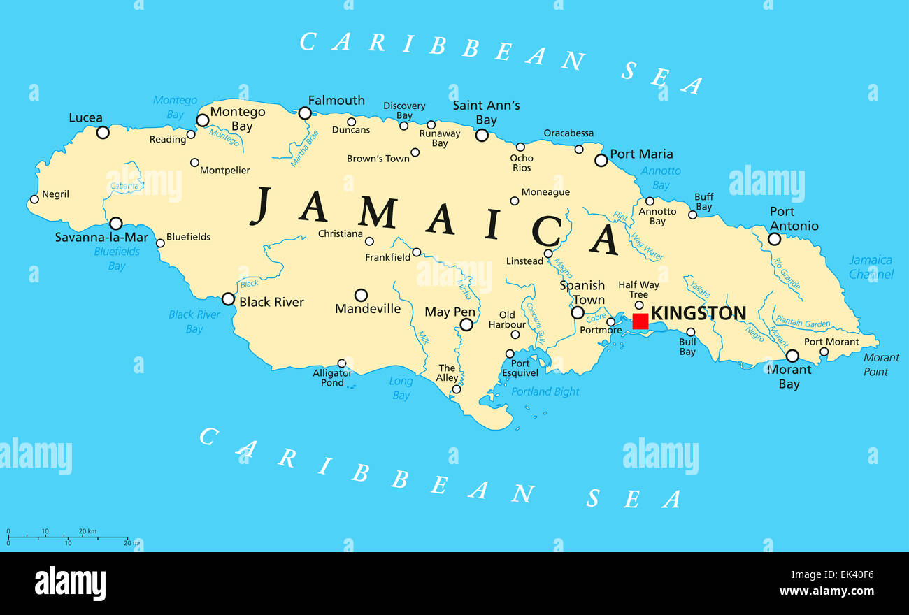
Jamaica is next in-line for a big hit from Beryl.
The chance for Beryl to end up in the group of worst storms to affect Jamaica since 1950 is unfortunately increasing. Those worst storms are Dean (2007), Ivan (2004), Gilbert (1988), and Charlie (1951). Dean and Ivan missed a little to the S while Gilbert and Charlie went right over it lengthwise. All 4 were MHs at/near Jamaica. Gilbert appears to have been the worst though I’m not sure as they were all bad.
I pray this won’t be as bad as it appears may be the case.
Thank YOU, Larry!
Looks like Beryl has peaked at 160 mph?
Now slowly weakening but extremely dangerous, especially for Jamaica as you mentioned. Looks like much of the Island will be on the RIGHT side of the major hurricane which is moving pretty fast at around 25 mph. On the right side, that speed ADDS to the wind speed of the hurricane )-:
https://www.nhc.noaa.gov/refresh/graphics_at2+shtml/235609.shtml?cone#contents

Beryl is moving just north of westerly at around 25 mph right now.
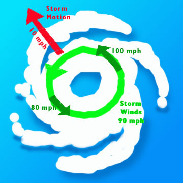
If Beryl's max winds are 130 mph at 2pm tomorrow when hitting Jamaica and the center is along the southern coast then:
On the right/north side, the speed ADDS 25 mph to the circulating wind speed and we get 130 +25 =155 mph winds felt at the surface over much of the island which has the eye wall passing thru.
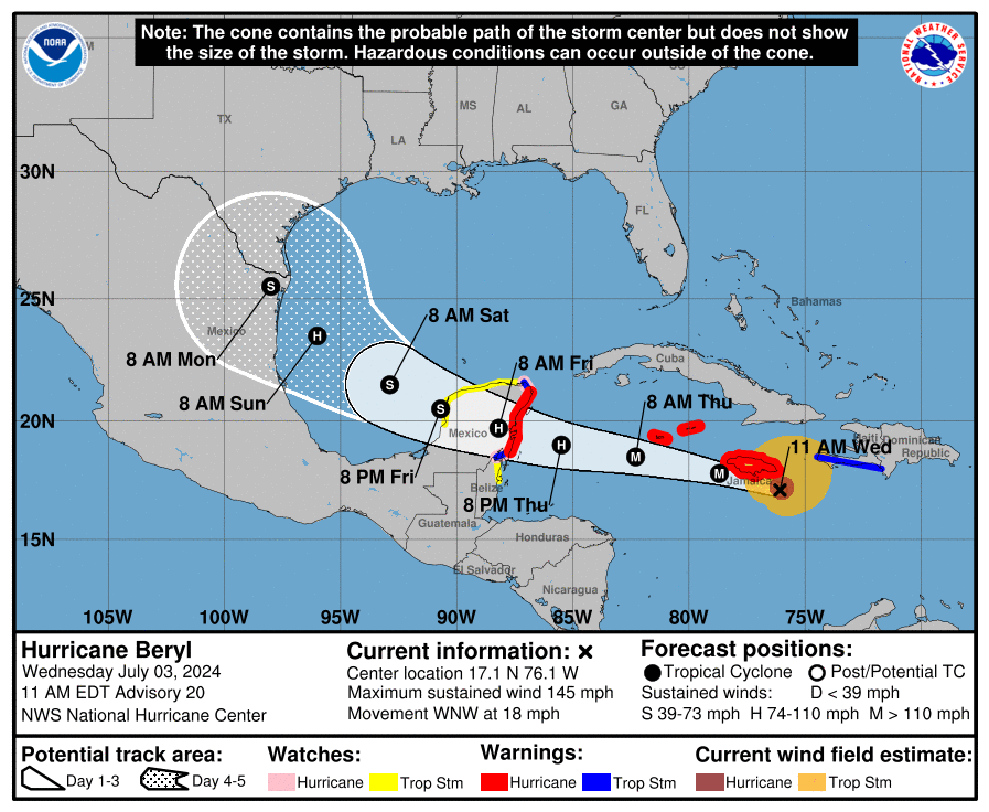
Hurricane Beryl Advisory Number  20
NWS National Hurricane Center Miami FL       AL022024
1100 AM EDT Wed Jul 03 2024

...TROPICAL STORM CONDITIONS SPREADING ACROSS JAMAICA WITH
HURRICANE CONDITIONS EXPECTED DURING THE NEXT SEVERAL HOURS...
...EYE OF BERYL EXPECTED TO APPROACH THE CAYMAN ISLANDS TONIGHT
INTO THURSDAY...


SUMMARY OF 1100 AM EDT...1500 UTC...INFORMATION
-----------------------------------------------
LOCATION...17.1N 76.1W
ABOUT 75 MI...125 KM SE OF KINGSTON JAMAICA
ABOUT 365 MI...590 KM ESE OF GRAND CAYMAN
MAXIMUM SUSTAINED WINDS...145 MPH...230 KM/H
PRESENT MOVEMENT...WNW OR 285 DEGREES AT 18 MPH...30 KM/H
MINIMUM CENTRAL PRESSURE...954 MB...28.17 INCHES
At 1100 AM EDT (1500 UTC), the center of Hurricane Beryl was located
near latitude 17.1 North, longitude 76.1 West. Beryl is moving
toward the west-northwest near 18 mph (30 km/h), and this general
motion should continue through today, followed by a turn more toward
the west tonight or Thursday.  On the forecast track, the center of
Beryl will pass near or over Jamaica during the next several hours.
After that, the center is expected to pass near or over the Cayman
Islands tonight or early Thursday and move over the Yucatan
Peninsula of Mexico Thursday night or early Friday.
Thanks much Larry!
Jamaica will be decimated today )-:
Winds of 140 mph(with slight weakening going on) +18 mph for areas on the right/dirty side of the hurricane add up to 158 mph.
https://www.nhc.noaa.gov/text/refresh/MIATCDAT2+shtml/031447.shtml?
https://www.youtube.com/watch?v=iytYxKdUSCo
++++++++++++++++
Even if the eye passes right over Jamaica, as it approaches, the EYE WALL and the right side of the hurricane will have to pass by FIRST.
Then, after the brief and relatively calm of the eye passes, the winds will pick up again and the BACK SIDE of the hurricane will hit. The eye wall with the highest winds will pass again, with winds in the complete opposite direction.......BUT ON THE LEFT SIDE of the hurricane, so the 18 mph speed of the hurricane will SUBTRACT from the winds.
If winds were still at 140 mph then -18 mph = 122 mph from the 2nd surge in winds after the eye passes and the back side of the hurricane hits.
This is LESS damaging overall, however different objects will be exposed and more vulnerable from the new direction that were more protected/sheltered during the approach with the higher winds.
From NHC at 5 PM:
...EYEWALL OF BERYL BRUSHING THE SOUTH COAST OF JAMAICA
WITH HURRICANE CONDITIONS OCCURRING...
...THE HURRICANE IS EXPECTED TO APPROACH THE CAYMAN ISLANDS TONIGHT
INTO THURSDAY AND THE YUCATAN PENINSULA THURSDAY NIGHT...


SUMMARY OF 500 PM EDT...2100 UTC...INFORMATION
----------------------------------------------
LOCATION...17.5N 77.6W
ABOUT 65 MI...100 KM WSW OF KINGSTON JAMAICA
ABOUT 265 MI...430 KM ESE OF GRAND CAYMAN
MAXIMUM SUSTAINED WINDS...140 MPH...220 KM/H
PRESENT MOVEMENT...WNW OR 285 DEGREES AT 20 MPH...31 KM/H
MINIMUM CENTRAL PRESSURE...959 MB...28.32 INCHES
Hurricane-force winds extend outward up to 45 miles (75 km) from the
center and tropical-storm-force winds extend outward up to 185 miles
(295 km). Kingston, Jamaica, recently reported sustained winds of
48 mph (78 km/h) and a wind gust of 81 mph (130 km/h).
Thanks much, Larry!
Kingston, in southeast Jamaica and along the coast, just north of the center of the hurricane must have MISSED the brunt of the highest winds.
Only experiencing sustained winds of 48 mph with a max wind gust of 81 mph when the hurricane's eye wall and right side could be featuring 140mph +17 mph = 157 mph winds.
I'll guess that the hurricane and its eye wall must have been SOUTH of Kingston AND the wind velocities we are getting from the NHC don't accurately correlate with observed surface winds(they are much too high vs measured surface winds).
I get that friction over land will slow down the winds a bit but this is MUCH MORE than a bit.
Regardless, areas farther west of Kingston, jutting out farther south likely have or had MUCH higher winds.


8PM NHC:
Hurricane Beryl Intermediate Advisory Number 21A
NWS National Hurricane Center Miami FL       AL022024
800 PM EDT Wed Jul 03 2024

...EYEWALL OF EXTREMELY DANGEROUS CATEGORY 4 BERYL MOVING NEAR
SOUTHWESTERN JAMAICA...
...EXPECTED TO APPROACH THE CAYMAN ISLANDS LATER TONIGHT...


SUMMARY OF 800 PM EDT...0000 UTC...INFORMATION
----------------------------------------------
LOCATION...17.8N 78.3W
ABOUT 100 MI...160 KM W OF KINGSTON JAMAICA
ABOUT 215 MI...350 KM ESE OF GRAND CAYMAN
MAXIMUM SUSTAINED WINDS...130 MPH...215 KM/H
PRESENT MOVEMENT...WNW OR 285 DEGREES AT 20 MPH...31 KM/H
MINIMUM CENTRAL PRESSURE...960 MB...28.35 INCHES
Thanks, Larry!
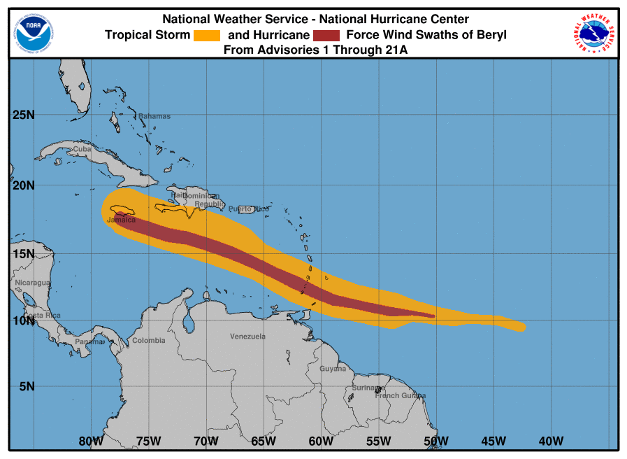
several of the damage images from before/after are from Grenada on the bottom map. If anything, this is a good geography lesson about the Caribbean Islands!!!
This is the geography and names of the places:
https://www.google.com/maps/@19.3662741,-77.6694668,5z?entry=ttu

This was the path of the hurricane/tropical force winds:
https://www.nhc.noaa.gov/refresh/graphics_at2+shtml/235430.shtml?swath#contents
YW, Mike.
Well, the Energizer Bunny is still a cat 4 at 11PM!
Hurricane Beryl Advisory Number  22
NWS National Hurricane Center Miami FL       AL022024
1100 PM EDT Wed Jul 03 2024

...CATEGORY 4 HURRICANE BERYL PULLING AWAY FROM JAMAICA...
...EXPECTED TO PASS JUST SOUTH OF THE CAYMAN ISLANDS OVERNIGHT...


SUMMARY OF 1100 PM EDT...0300 UTC...INFORMATION
-----------------------------------------------
LOCATION...18.0N 79.2W
ABOUT 160 MI...255 KM SE OF GRAND CAYMAN
ABOUT 560 MI...905 KM ESE OF TULUM MEXICO
MAXIMUM SUSTAINED WINDS...130 MPH...215 KM/H
PRESENT MOVEMENT...WNW OR 290 DEGREES AT 21 MPH...33 KM/H
MINIMUM CENTRAL PRESSURE...961 MB...28.38 INCHES
Beryl has finally fallen below cat 4 as it is now a strong cat 3. It appears that SW Jamaica may have been the hardest hit of that island.
 Get ready Caymans, especially Grand Cayman!

Hurricane Beryl Intermediate Advisory Number 22A
NWS National Hurricane Center Miami FL       AL022024
200 AM EDT Thu Jul 04 2024

...STRONG WINDS, DANGEROUS STORM SURGE AND DAMAGING WAVES EXPECTED
ACROSS THE CAYMAN ISLANDS OVERNIGHT...


SUMMARY OF 200 AM EDT...0600 UTC...INFORMATION
----------------------------------------------
LOCATION...18.3N 80.1W
ABOUT 110 MI...175 KM SE OF GRAND CAYMAN
ABOUT 500 MI...800 KM ESE OF TULUM MEXICO
MAXIMUM SUSTAINED WINDS...125 MPH...205 KM/H
PRESENT MOVEMENT...WNW OR 285 DEGREES AT 21 MPH...33 KM/H
MINIMUM CENTRAL PRESSURE...965 MB...28.50 INCHES
Still hanging on to major H status:

Hurricane Beryl Intermediate Advisory Number 23A
NWS National Hurricane Center Miami FL       AL022024
800 AM EDT Thu Jul 04 2024

...CENTER OF BERYL PASSING SOUTHWEST OF GRAND CAYMAN ISLAND...
...STRONG WINDS, DANGEROUS STORM SURGE, AND DAMAGING WAVES EXPECTED
IN THE CAYMAN ISLANDS THIS MORNING...


SUMMARY OF 800 AM EDT...1200 UTC...INFORMATION
----------------------------------------------
LOCATION...18.7N 81.8W
ABOUT 50 MI...80 KM SW OF GRAND CAYMAN
ABOUT 385 MI...620 KM ESE OF TULUM MEXICO
MAXIMUM SUSTAINED WINDS...120 MPH...195 KM/H
PRESENT MOVEMENT...WNW OR 285 DEGREES AT 20 MPH...31 KM/H
MINIMUM CENTRAL PRESSURE...968 MB...28.59 INCHES
Hurricane Beryl Advisory Number  24
NWS National Hurricane Center Miami FL       AL022024
1100 AM EDT Thu Jul 04 2024

...CENTER OF BERYL MOVING AWAY FROM THE CAYMAN ISLANDS...
...STRONG WINDS, DANGEROUS STORM SURGE, AND DAMAGING WAVES EXPECTED
ON THE COAST OF THE YUCATAN PENINSULA OF MEXICO BY EARLY FRIDAY...


SUMMARY OF 1100 AM EDT...1500 UTC...INFORMATION
-----------------------------------------------
LOCATION...19.0N 82.6W
ABOUT 95 MI...150 KM WSW OF GRAND CAYMAN
ABOUT 330 MI...530 KM ESE OF TULUM MEXICO
MAXIMUM SUSTAINED WINDS...115 MPH...185 KM/H
PRESENT MOVEMENT...WNW OR 285 DEGREES AT 18 MPH...30 KM/H
MINIMUM CENTRAL PRESSURE...971 MB...28.68 INCHES
FORECAST POSITIONS AND MAX WINDS

INIT  04/1500Z 19.0N  82.6W  100 KT 115 MPH
 12H  05/0000Z 19.5N  85.1W   90 KT 105 MPH
 24H  05/1200Z 20.1N  87.9W   70 KT  80 MPH...INLAND
 36H  06/0000Z 20.9N  90.3W   50 KT  60 MPH...INLAND
 48H  06/1200Z 22.0N  92.4W   50 KT  60 MPH...OVER WATER
 60H  07/0000Z 23.0N  94.2W   55 KT  65 MPH
 72H  07/1200Z 23.9N  95.7W   60 KT  70 MPH
 96H  08/1200Z 25.5N  97.5W   65 KT  75 MPH...INLAND
120H  09/1200Z 28.0N  99.5W   30 KT  35 MPH...INLAND

$$
Forecaster Beven
NHC 11AM forecast yesterday:
36H 05/0000Z 19.0N 85.5W 90 KT 105 MPH
NHC 5AM forecast today:
12H 04/1800Z 19.0N 83.6W 95 KT 110 MPH
NHC 11AM actual location:
INIT 04/1500Z 19.0N 82.6W 100 KT 115 MPH
By comparing these 3, one can see the trend that she gets as far N as 19.0N at a further E longitude: note that current location of 19.0N is with longitude of 82.6W vs 85.5W on yesterday’s 11AM forecast and 83.6W on today’s 5AM forecast. The implications are that this may mean a further N landfall in the W Gulf than earlier forecasted.
Great observation, Larry!
Latest 5 day forecast:
https://www.nhc.noaa.gov/refresh/graphics_at2+shtml/144841.shtml?cone#contents

Forecast earlier in the week, 3 days ago. It didn't go out as far but we can see the later portion of the old forecasts, didn't turn the storm as far to the right/north/pole-ward as the latest forecast above.
Re: Re: Invest 95L headed to Caribbean: could become Beryl before
Thanks, Mike.
BULLETIN
Hurricane Beryl Intermediate Advisory Number 24A
NWS National Hurricane Center Miami FL AL022024
200 PM EDT Thu Jul 04 2024
...CENTER OF BERYL MOVING ACROSS THE NORTHWESTERN CARIBBEAN SEA...
...STRONG WINDS, DANGEROUS STORM SURGE, AND DAMAGING WAVES EXPECTED
ON THE COAST OF THE YUCATAN PENINSULA OF MEXICO BY EARLY FRIDAY...
SUMMARY OF 200 PM EDT...1800 UTC...INFORMATION
----------------------------------------------
LOCATION...19.2N 83.4W
ABOUT 135 MI...215 KM W OF GRAND CAYMAN
ABOUT 275 MI...445 KM ESE OF TULUM MEXICO
MAXIMUM SUSTAINED WINDS...110 MPH...175 KM/H
PRESENT MOVEMENT...WNW OR 285 DEGREES AT 18 MPH...30 KM/H
MINIMUM CENTRAL PRESSURE...974 MB...28.76 INCHES
Hurricane Beryl Advisory Number 25
NWS National Hurricane Center Miami FL AL022024
500 PM EDT Thu Jul 04 2024
...CENTER OF BERYL HEADING FOR THE YUCATAN PENINSULA OF MEXICO...
...STRONG WINDS, DANGEROUS STORM SURGE, AND DAMAGING WAVES EXPECTED
ON THE COAST OF THE YUCATAN PENINSULA BY EARLY FRIDAY...
SUMMARY OF 500 PM EDT...2100 UTC...INFORMATION
----------------------------------------------
LOCATION...19.5N 84.3W
ABOUT 215 MI...345 KM ESE OF TULUM MEXICO
ABOUT 200 MI...325 KM W OF GRAND CAYMAN
MAXIMUM SUSTAINED WINDS...110 MPH...175 KM/H
PRESENT MOVEMENT...WNW OR 285 DEGREES AT 20 MPH...31 KM/H
MINIMUM CENTRAL PRESSURE...974 MB...28.77 INCHES
Hurricane Beryl Advisory Number 26
NWS National Hurricane Center Miami FL AL022024
1000 PM CDT Thu Jul 04 2024
...MAJOR HURRICANE BERYL IS APPROACHING THE YUCATAN PENINSULA...
...HURRICANE-FORCE WINDS, DANGEROUS STORM SURGE, AND DAMAGING WAVES
EXPECTED TO BEGIN OVERNIGHT...
SUMMARY OF 1000 PM CDT...0300 UTC...INFORMATION
-----------------------------------------------
LOCATION...19.6N 85.5W
ABOUT 135 MI...220 KM ESE OF TULUM MEXICO
MAXIMUM SUSTAINED WINDS...115 MPH...185 KM/H
PRESENT MOVEMENT...W OR 275 DEGREES AT 16 MPH...26 KM/H
MINIMUM CENTRAL PRESSURE...964 MB...28.47 INCHES
———————————-
FORECAST POSITIONS AND MAX WINDS
INIT 05/0300Z 19.6N 85.5W 100 KT 115 MPH
12H 05/1200Z 20.0N 87.5W 95 KT 110 MPH...INLAND
24H 06/0000Z 20.9N 89.9W 55 KT 65 MPH...INLAND
36H 06/1200Z 21.9N 92.1W 55 KT 65 MPH...OVER WATER
48H 07/0000Z 22.9N 94.0W 60 KT 70 MPH
60H 07/1200Z 23.8N 95.5W 65 KT 75 MPH
72H 08/0000Z 24.7N 96.6W 70 KT 80 MPH
96H 09/0000Z 26.8N 98.6W 45 KT 50 MPH...INLAND
120H 10/0000Z 28.9N 99.1W 25 KT 30 MPH...INLAND
$$
Forecaster Cangialosi
Hurricane Beryl Advisory Number  28
NWS National Hurricane Center Miami FL       AL022024
1000 AM CDT Fri Jul 05 2024

...BERYL WEAKENING AS IT MOVES FARTHER INLAND OVER THE
NORTHEASTERN YUCATAN PENINSULA...
...DANGEROUS HURRICANE-FORCE WINDS, STORM SURGE, AND DAMAGING WAVES
EXPECTED OVER PORTIONS OF THIS AREA FOR A FEW MORE HOURS...


SUMMARY OF 1000 AM CDT...1500 UTC...INFORMATION
-----------------------------------------------
LOCATION...20.7N 88.3W
ABOUT 100 MI...160 KM ESE OF PROGRESO MEXICO
ABOUT 680 MI...1095 KM ESE OF BROWNSVILLE TEXAS
MAXIMUM SUSTAINED WINDS...85 MPH...140 KM/H
PRESENT MOVEMENT...WNW OR 290 DEGREES AT 16 MPH...26 KM/H
MINIMUM CENTRAL PRESSURE...980 MB...28.94 INCHES
Hurricane Beryl Discussion Number  28
NWS National Hurricane Center Miami FL       AL022024
1000 AM CDT Fri Jul 05 2024

The center of Beryl made landfall on the Yucatan Peninsula of
Mexico just northeast of Tulum at about 11Z. The landfall intensity
is somewhat uncertain, but surface observations suggest the central
pressure rose into the 977-980 mb range before landfall.
FORECAST POSITIONS AND MAX WINDS

INIT  05/1500Z 20.7N  88.3W   75 KT  85 MPH...INLAND
 12H  06/0000Z 21.4N  90.1W   55 KT  65 MPH...OVER WATER
 24H  06/1200Z 22.5N  92.2W   55 KT  65 MPH
 36H  07/0000Z 23.6N  94.1W   60 KT  70 MPH
 48H  07/1200Z 24.6N  95.6W   65 KT  75 MPH
 60H  08/0000Z 25.6N  96.6W   70 KT  80 MPH
 72H  08/1200Z 26.8N  97.5W   75 KT  85 MPH...NEAR COAST
 96H  09/1200Z 29.0N  98.0W   35 KT  40 MPH...INLAND
120H  10/1200Z 31.0N  97.0W   25 KT  30 MPH...INLAND

$$
Forecaster Beven
Thanks much, Larry!
Briefly back to min hurricane before hitting far southern TX and remnants tracking thru eastern TX, then northward, curving east towards the(western) Mid-South where it might cause mostly bearish rains for cotton after hitting TX.
https://www.nhc.noaa.gov/text/refresh/MIATCDAT2+shtml/051451.shtml?
https://www.nhc.noaa.gov/refresh/graphics_at2+shtml/174634.shtml?cone#contents

ON JULY 3, IT WAS THIS MAP THAT I TOLD MY SISTER: "BERYL IS GONNA GO NORTH & RIDE THE COAST OF TEXAS." WE'LL SEE.

Hey Jean,
The NHC has requested that you become their chief forecaster ASAP! ;) I’m no longer sure that Mike is the only met. posting regularly here!
Seriously, the forecasted landfall has since changed to TX. So, much deserved kudos. Beryl’s now just a high end TS and is still weakening but for how long?
4:00 PM CDT Fri Jul 5
Location: 21.2°N 89.2°W
Moving: WNW at 15 mph
Min pressure: 989 mb
Max sustained: 65 mph
———————————-
CHANGES WITH THIS ADVISORY:

A Hurricane Watch is now in effect for the Texas coast from the
mouth of the Rio Grande northward to Sargent.

A Storm Surge Watch is now in effect for the Texas coast from the
mouth of the Rio Grande northward to Sargent.

The Meteorological Service of Mexico has issued a Hurricane Watch
for the northeastern coast of Mexico from Barra el Mezquital to
the mouth of the Rio Grande.
Continued weakening is expected during the
next few hours as Beryl crosses the Yucatan Peninsula.
Re-intensification is expected once the center moves back over the
Gulf of Mexico, and Beryl is forecast to regain hurricane status on Sunday.
The track guidance has shifted eastward since the previous advisory,
with the most notable change being the ECMWF model, which is now on
the eastern side of the guidance envelope.  The new forecast track
is shifted east of the previous track, but it still lies to the
west of the various consensus models. Therefore, additional
adjustments of the forecast track could be necessary tonight.
Beryl will likely weaken a little more before the center emerges
over the Gulf of Mexico this evening.  After that, it could take
12-24 h for the cyclone's structure to recover over the Gulf of
Mexico before re-intensification begins in earnest, and during
this time the large-scale models suggest continued southwesterly
shear.  Based on this and the overall trend of the intensity
guidance, the new forecast calls for gradual strengthening to start
around 24 h, and the first part of this forecast could be a bit
generous.  However, the upper-level winds become more favorable as
the cyclone approaches the western Gulf coast after 36 h, with
decreasing shear and increasing upper-level divergence.  This
combination should allow a faster rate of strengthening.  The new
intensity forecast now calls for an 80-kt intensity at landfall in
best agreement with the HWRF, HAFS-B, and HMON models, and this
could be conservative if Beryl stays over water longer than
currently forecast.
FORECAST POSITIONS AND MAX WINDS

INIT  05/2100Z 21.2N  89.2W   55 KT  65 MPH...INLAND
 12H  06/0600Z 22.0N  91.0W   50 KT  60 MPH...OVER WATER
 24H  06/1800Z 23.2N  93.0W   55 KT  65 MPH
 36H  07/0600Z 24.3N  94.6W   60 KT  70 MPH
 48H  07/1800Z 25.3N  95.9W   65 KT  75 MPH
 60H  08/0600Z 26.5N  96.8W   70 KT  80 MPH
 72H  08/1800Z 27.8N  97.3W   80 KT  90 MPH...AT COAST
 96H  09/1800Z 30.5N  97.0W   30 KT  35 MPH...INLAND
120H  10/1800Z 32.5N  95.5W   25 KT  30 MPH...POST-TROP/INLAND

$$
Forecaster Beven
LOLOLOL, LARRY
I'VE GOT FRIENDS VACATIONING IN THE HOMOSASSA, FL. AREA FOR 2 MORE WEEKS. I DON'T WANNA DISRUPT THEIR VACATION, BUT... I'M GONNA TELL 'EM TO KEEP CLOSE TRACK OF THE WEATHER. THEY LIVE IN VA. & THEY'LL NEED TO GO THRU GA. & THE COASTAL AREAS OF THE CAROLINAS TO GET THERE.
WHAT FUNNNNNNNNNN
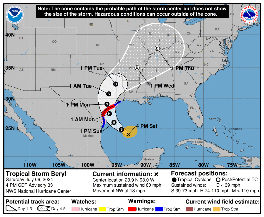
Tropical Storm Beryl Advisory Number  33
NWS National Hurricane Center Miami FL       AL022024
400 PM CDT Sat Jul 06 2024

...HURRICANE AND STORM SURGE WARNINGS ISSUED FOR PORTIONS OF THE
COAST OF TEXAS...
...HURRICANE-FORCE WINDS, LIFE-THREATENING STORM SURGE, AND HEAVY
RAINS EXPECTED IN PORTIONS OF SOUTH TEXAS...


SUMMARY OF 400 PM CDT...2100 UTC...INFORMATION
----------------------------------------------
LOCATION...23.9N 93.0W
ABOUT 385 MI...615 KM SE OF CORPUS CHRISTI TEXAS
MAXIMUM SUSTAINED WINDS...60 MPH...95 KM/H
PRESENT MOVEMENT...NW OR 310 DEGREES AT 13 MPH...20 KM/H
MINIMUM CENTRAL PRESSURE...997 MB...29.44 INCHES


WATCHES AND WARNINGS
--------------------
CHANGES WITH THIS ADVISORY:

A Hurricane Warning is now in effect for the Texas coast from
Baffin Bay northward to Sargent.

A Tropical Storm Warning is now in effect for the Texas coast
north of Sargent to High Island.

A Storm Surge Warning has been issued from North Entrance of
the Padre Island National Seashore northward to San Luis Pass,
including Corpus Christi Bay and Matagorda Bay.

A Storm Surge Watch has been issued along the Texas coast east of
High Island to Sabine Pass.
https://www.nhc.noaa.gov/refresh/graphics_at2+shtml/212126.shtml?cone#contents
Freeze frame image.
This is the mostly likely rain shield path from the remnants of Beryl after coming up thru eastern TX. No chance for FL to be impacted, jean.
7 Day Total precipitation below: Updates constantly to the latest.
http://www.wpc.ncep.noaa.govcdx /qpf/p168i.gif?1530796126

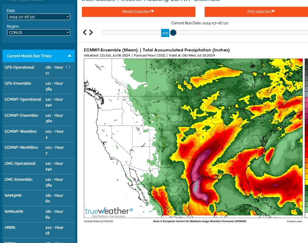
Here it is from the European model thru the next 4 days.
Rains potentially benefiting Indiana and even where you live in OH, Jean!
This is a freeze frame from the 12z Sat run that doesn't update. The other rain forecasts on this page DO update automatically.
Excessive rain threat. Updates constantly to the latest.
https://www.wpc.ncep.noaa.gov/qpf/excess_rain.shtml
Current Day 1 Forecast
Day 1 Threat Area in Text Format
Current Day 2 Forecast |
Day 3 outlook

Surface Weather maps for days 3-7 below:
https://www.wpc.ncep.noaa.gov/medr/medr.shtml

Technical discussion:
https://www.wpc.ncep.noaa.gov/discussions/hpcdiscussions.php?disc=pmdepd
Tropical Storm Beryl Advisory Number  34
NWS National Hurricane Center Miami FL       AL022024
1000 PM CDT Sat Jul 06 2024

...BERYL FORECAST TO STRENGTHEN TO A HURRICANE AGAIN BEFORE
LANDFALL...
...HURRICANE AND STORM SURGE WARNINGS IN EFFECT FOR PORTIONS OF THE
TEXAS COAST...


SUMMARY OF 1000 PM CDT...0300 UTC...INFORMATION
-----------------------------------------------
LOCATION...24.7N 94.0W
ABOUT 300 MI...485 KM SE OF CORPUS CHRISTI TEXAS
MAXIMUM SUSTAINED WINDS...60 MPH...95 KM/H
PRESENT MOVEMENT...NW OR 310 DEGREES AT 13 MPH...20 KM/H
MINIMUM CENTRAL PRESSURE...993 MB...29.33 INCHES
FORECAST POSITIONS AND MAX WINDS

INIT  07/0300Z 24.7N  94.0W   50 KT  60 MPH
 12H  07/1200Z 25.7N  95.1W   60 KT  70 MPH
 24H  08/0000Z 27.1N  96.0W   75 KT  85 MPH
 36H  08/1200Z 28.8N  96.6W   75 KT  85 MPH...INLAND
 48H  09/0000Z 30.7N  96.5W   40 KT  45 MPH...INLAND
 60H  09/1200Z 32.6N  95.4W   30 KT  35 MPH...INLAND
 72H  10/0000Z 34.5N  93.6W   20 KT  25 MPH...POST-TROP/INLAND
 96H  11/0000Z 37.8N  89.0W   20 KT  25 MPH...POST-TROP/INLAND
120H  12/0000Z 41.3N  84.3W   20 KT  25 MPH...POST-TROP/INLAND

$$
Forecaster Cangialosi
Tropical Storm Beryl Advisory Number  36
NWS National Hurricane Center Miami FL       AL022024
1000 AM CDT Sun Jul 07 2024

...BERYL BECOMING BETTER ORGANIZED AND FORECAST TO BECOME A
HURRICANE BEFORE LANDFALL...
...PREPARATIONS SHOULD BE RUSHED TO COMPLETION...


SUMMARY OF 1000 AM CDT...1500 UTC...INFORMATION
-----------------------------------------------
LOCATION...25.9N 95.1W
ABOUT 195 MI...315 KM SSE OF MATAGORDA TEXAS
ABOUT 195 MI...310 KM SE OF CORPUS CHRISTI TEXAS
MAXIMUM SUSTAINED WINDS...65 MPH...100 KM/H
PRESENT MOVEMENT...NW OR 325 DEGREES AT 10 MPH...17 KM/H
MINIMUM CENTRAL PRESSURE...992 MB...29.29 INCHES
FORECAST POSITIONS AND MAX WINDS

INIT  07/1500Z 25.9N  95.1W   55 KT  65 MPH
 12H  08/0000Z 27.1N  95.7W   65 KT  75 MPH
 24H  08/1200Z 29.2N  96.2W   75 KT  85 MPH...INLAND
 36H  09/0000Z 31.4N  95.7W   35 KT  40 MPH...INLAND
 48H  09/1200Z 33.6N  94.2W   25 KT  30 MPH...INLAND
 60H  10/0000Z 36.2N  91.7W   25 KT  30 MPH...POST-TROP/INLAND
 72H  10/1200Z 38.6N  89.2W   20 KT  25 MPH...POST-TROP/INLAND
 96H  11/1200Z 42.8N  83.6W   20 KT  25 MPH...POST-TROP/INLAND
120H  12/1200Z 46.0N  79.0W   20 KT  25 MPH...POST-TROP/INLAND

$$
Forecaster Blake
*Note that the forecasted 85 mph as of 7AM CDT is when it has already been inland a few hours thus implying higher forecasted landfalling max winds.
Thanks, Larry!
MIKE SAID: "No chance for FL to be impacted, jean."
LOL DID I SAY BERYL WOULD BE / COULD BE THE CAUSE FOR CONCERN?
ANYHOO... SINCE WHEN IS THE NAME "BERYL" PRONOUNCED "BARREL"? I DATED A GUY IN HIGH SCHOOL NAMED BERYL & HAD AN AUNT NAMED BERYL. NEITHER PRONOUNCED THEIR NAME AS "BARREL"
BTW... I'VE YET TO CALL MY FRIENDS ON VACATION. I'LL LET YA KNOW, IF / WHEN I DO.
Sorry, Jean!
You're right, new tropical systems are always possible in that region at this time of year.
The remnants of this one have shifted slightly more to the left/west the past 24 hours. Could miss parts of IN/OH based on the NWS forecast below that would benefit from the rains but make IL very happy.
7 Day Total precipitation below: Updates constantly to the latest.
http://www.wpc.ncep.noaa.govcdx /qpf/p168i.gif?1530796126
The last 12z European model is a bit farther east/right:

This is who needs the rain:
https://www.marketforum.com/forum/topic/83844/#83853
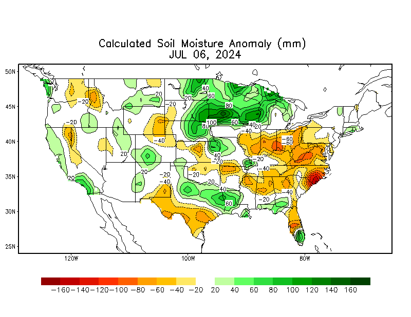
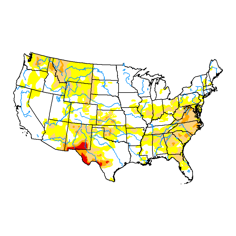
DROUGHT MONITOR
https://droughtmonitor.unl.edu/
Last map is from July 3, 2024
Tropical Storm Beryl Advisory Number  37
NWS National Hurricane Center Miami FL       AL022024
400 PM CDT Sun Jul 07 2024

...BERYL FORECAST TO BRING DANGEROUS STORM SURGE, FLASH FLOODING
AND STRONG WINDS TO TEXAS OVERNIGHT...


SUMMARY OF 400 PM CDT...2100 UTC...INFORMATION
----------------------------------------------
LOCATION...26.8N 95.5W
ABOUT 130 MI...205 KM SSE OF MATAGORDA TEXAS
ABOUT 135 MI...220 KM ESE OF CORPUS CHRISTI TEXAS
MAXIMUM SUSTAINED WINDS...65 MPH...100 KM/H
PRESENT MOVEMENT...NNW OR 335 DEGREES AT 12 MPH...19 KM/H
MINIMUM CENTRAL PRESSURE...988 MB...29.18 INCHES
FORECAST POSITIONS AND MAX WINDS

INIT  07/2100Z 26.8N  95.5W   55 KT  65 MPH
 12H  08/0600Z 28.3N  95.9W   75 KT  85 MPH
 24H  08/1800Z 30.4N  95.9W   50 KT  60 MPH...INLAND
 36H  09/0600Z 32.6N  94.8W   30 KT  35 MPH...INLAND
 48H  09/1800Z 34.9N  92.6W   25 KT  30 MPH...POST-TROP/INLAND
 60H  10/0600Z 37.2N  89.7W   20 KT  25 MPH...POST-TROP/INLAND
 72H  10/1800Z 39.7N  86.2W   20 KT  25 MPH...POST-TROP/INLAND
 96H  11/1800Z 43.5N  80.0W   25 KT  30 MPH...POST-TROP/INLAND
120H  12/1800Z...DISSIPATED

$$
Forecaster Blake
Tropical Storm Beryl Intermediate Advisory Number 37A
NWS National Hurricane Center Miami FL       AL022024
700 PM CDT Sun Jul 07 2024

...HURRICANE HUNTERS FIND BERYL SLIGHTLY STRONGER...
...DANGEROUS STORM SURGE, FLASH FLOODING, AND STRONG WINDS EXPECTED
OVERNIGHT IN PORTIONS OF TEXAS...


SUMMARY OF 700 PM CDT...0000 UTC...INFORMATION
----------------------------------------------
LOCATION...27.1N 95.6W
ABOUT 105 MI...170 KM SSE OF MATAGORDA TEXAS
ABOUT 120 MI...195 KM ESE OF CORPUS CHRISTI TEXAS
MAXIMUM SUSTAINED WINDS...70 MPH...110 KM/H
PRESENT MOVEMENT...NNW OR 340 DEGREES AT 12 MPH...19 KM/H
MINIMUM CENTRAL PRESSURE...987 MB...29.15 INCHES


WATCHES AND WARNINGS
--------------------
CHANGES WITH THIS ADVISORY:

The Hurricane Warning south of Port Aransas has been changed to a
Tropical Storm Warning.

The Storm Surge Warning south of Port Aransas, including Corpus
Christi Bay, has been discontinued.

The Tropical Storm Warning south of Port Mansfield has been
discontinued.
MIKE: "THEY" KEEP UPPING THE AMOUNT OF EXPECTED RAIN, FOR US. IT IS NOW AT 1.75 FROM TUES. EVENING THRU THURS. EARLY MORNING.
Beryl is now a hurricane:
CDT Sun Jul 7
Location: 27.7°N 95.7°W
Moving: NNW at 10 mph
Min pressure: 985 mb
Max sustained: 75 mph
—————————————
Hurricane Beryl Tropical Cyclone Update
NWS National Hurricane Center Miami FL       AL022024
1100 PM CDT Sun Jul 7 2024

...BERYL IS AGAIN A HURRICANE...

Data from the National Weather Service Doppler radar near Houston,
Texas, and reports from an Air Force Reserve Hurricane Hunter
aircraft indicate that Beryl's maximum sustained winds have
increased to near 75 mph (120 km/h).  Based on these data, Beryl is
upgraded to a hurricane. Additional strengthening is expected
before landfall on the Texas coast.

NOAA buoy 42019 recently reported sustained winds of 60 mph
(97 km/h) and a wind gust of 74 mph (119 km/h).  The buoy also
reported a pressure of 992.2 mb (29.30 inches).

SUMMARY OF 1100 PM CDT...0400 UTC...INFORMATION
-----------------------------------------------
LOCATION...27.7N 95.7W
ABOUT 65 MI...105 KM SSE OF MATAGORDA TEXAS
ABOUT 105 MI...170 KM E OF CORPUS CHRISTI TEXAS
MAXIMUM SUSTAINED WINDS...75 MPH...120 KM/H
PRESENT MOVEMENT...NNW OR 345 DEGREES AT 10 MPH...17 KM/H
MINIMUM CENTRAL PRESSURE...985 MB...29.09 INCHES

$$
Forecaster Beven
BERYL... 12 YEARS AGO LOL 3 MINUTES
Good find, Jean!
They use the exact same names every 6 years(so there was a Beryl in 2018 too).........unless a system does something noteworthy. Then they retire that name and replace it with a new name having the same first letter 6 years later.
Not sure what the new B hurricane name will be in 2030.
HURRICANE BERYL
(AL022018)
4–15 July 2018
https://www.nhc.noaa.gov/data/tcr/AL022018_Beryl.pdf
2006 Hurricane season
https://en.wikipedia.org/wiki/2006_Atlantic_hurricane_season
| Tropical storm (SSHWS) | |

 | |
| Duration | July 18 – July 21 |
|---|---|
| Peak intensity | 60 mph (95 km/h) (1-min); 1000 mbar (hPa) |
The same frontal system that developed the previous storm also produced another low-pressure area east of North Carolina.[17][31] The system was broad and ill-defined at first,[32] although the low-level circulation became sufficiently organized to be designated a tropical depression on July 18, about 290 mi (465 km) east-southeast of the coast of North Carolina. Later that day, the depression developed organized rainbands over the eastern periphery of the circulation, and as a result, the NHC upgraded it to Tropical Storm Beryl. The nascent storm moved generally northward at first along the western periphery of a subtropical ridge, parallel to the East Coast of the United States. With low wind shear and favorable outflow, Beryl intensified to reach a peak intensity of 60 mph (97 km/h) early on July 20.[17] Around that time, the storm developed an eye-like feature in the center of the convection.[33] Cooler waters caused Beryl to weaken, as it turned northeastward ahead of an approaching trough. Early on July 21, the storm struck the island of Nantucket with winds of 50 mph (85 km/h). Shortly thereafter, Beryl transitioned into an extratropical cyclone, which moved through Nova Scotia before merging with another extratropical cyclone on July 22 over Newfoundland.[
+++++++++
Tropical Cyclone Report
Tropical Storm Beryl
13 - 15 August 2000
https://www.nhc.noaa.gov/data/tcr/AL052000_Beryl.pdf
+++++++++++
https://en.wikipedia.org/wiki/Tropical_Storm_Beryl_(1994)
+++++++++
https://en.wikipedia.org/wiki/Tropical_Storm_Beryl_(1988)
++++++++++
https://en.wikipedia.org/wiki/Tropical_Storm_Beryl_(1982)
++++++++++
Hurricane Belle (1976) was a strong tropical cyclone that caused moderate damage across the East Coast of the United States in August 1976.
https://en.wikipedia.org/wiki/Hurricane_Belle
+++++++++++++
We can see above, that Hurricane Belle was significant enough in 1976, to retire that name and replace it with Beryl. The name Beryl stuck for 1982, 1988, 1994, 2000, 2006, 2012(your video) 2018 and this last SIGNIFICANT Beryl in 2024, which will be retired forever and replaced with a new B name in 2030.
So we've had 8 Beryl's(1982-2024 =42 years). I wonder what the record is for the most storms with the same name?
This discussion below may not be accurate/complete as it doesn't list the retired name "Belle" from 1976 that was noted on the previous page and started the replacement name Beryl in 1982.
HAS THERE EVER BEEN A BONNIE? I'LL GUESS: YES.
MY BONNIE LIES OVER THE OCEAN. LOL
EDIT.... I SEE BONNIE IS COMIN' UP IN 2028. LOL
Good one, Jean!
TUES. & WED. FORECAST... UPPED IT TO 2.8"
Thanks, Jean and Mike.
Recap of last few hours:
Hurricane Beryl Advisory Number  39
NWS National Hurricane Center Miami FL       AL022024
400 AM CDT Mon Jul 08 2024

...CENTER OF BERYL MAKES LANDFALL NEAR MATAGORDA TEXAS...
...DANGEROUS STORM SURGE AND STRONG WINDS OCCURRING WITH FLASH
FLOODING EXPECTED...


SUMMARY OF 400 AM CDT...0900 UTC...INFORMATION
----------------------------------------------
LOCATION...28.6N 96.0W
ABOUT 0 MI...0 KM N OF MATAGORDA TEXAS
ABOUT 85 MI...135 KM SSW OF HOUSTON TEXAS
MAXIMUM SUSTAINED WINDS...80 MPH...130 KM/H
PRESENT MOVEMENT...N OR 355 DEGREES AT 12 MPH...19 KM/H
MINIMUM CENTRAL PRESSURE...979 MB...28.91 INCHES
Hurricane Beryl Tropical Cyclone Update
NWS National Hurricane Center Miami FL       AL022024
500 AM CDT Mon Jul 8 2024

...LIFE-THREATENING STORM SURGE AND STRONG WINDS OCCURING IN EAST
TEXAS...
...500 AM CDT POSITION UPDATE...

Beryl is moving inland over eastern Texas. Life-threatening storm
surge and heavy rainfall is ongoing across portions of Texas.
Damaging winds ongoing along the coast, with strong winds moving
inland.

A mesonet station (SRDT2) in San Bernard recently reported a
sustained wind of 52 mph (84 km/h) and a gust of 91 mph (146 km/h)

A mesonet station (FRPT2) in Freeport recently reported a wind gust
of 92 mph (148 km/h).
Hurricane Beryl Tropical Cyclone Update
NWS National Hurricane Center Miami FL       AL022024
900 AM CDT Mon Jul 8 2024

...DAMAGING WINDS AND FLOODING RAINFALL CONTINUE ACROSS PORTIONS
OF SOUTHEAST TEXAS INCLUDING THE HOUSTON AREA...
...900 AM CDT POSITION UPDATE...

Houston Hobby Airport (KHOU) recently reported a sustained wind of
58 mph (93 km/h) and a gust of 84 mph (135 km/h).

A National Ocean Service (NOS) station at Morgans Point recently
measured a sustained wind of 66 mph (106 km/h) and a gust to 77 mph
(124 km/h).

SUMMARY OF 900 AM CDT...1400 UTC...INFORMATION
-----------------------------------------------
LOCATION...29.7N 95.7W
ABOUT 20 MI...30 KM W OF HOUSTON TEXAS
MAXIMUM SUSTAINED WINDS...75 MPH...120 KM/H
PRESENT MOVEMENT...N OR 10 DEGREES AT 12 MPH...19 KM/H
MINIMUM CENTRAL PRESSURE...981 MB...28.97 INCHES

$$
Forecaster Hagen/Blake
This is quite the storm in the Houston area and quite the impactful storm for a low end car 1. A strengthening cat 1 like Beryl is often worse than a weakening cat 2 because the strong winds above the surface often mix down more efficiently in a strengthening TC.
and A strengthening cat 1 like Beryl is often worse than a weakening cat 2 because the strong winds above the surface often mix down more efficiently in a strengthening TC."
Thanks, Larry!
Where do you get this from?
Mike, you’re welcome.
I learned this over the years from hanging out at wx BBs like American and Storm 2K and reading Joe Bastardi at Accuwx/WxBell. It has been mentioned several times this morning at both BBs and also yesterday by JB. There’s no question based on my decades of following these storms that Beryl’s TX overall impacts have been worse than the avg 80 mph (toward the lower end of cat 1) storm.
Thanks!
I think that the main reason that Houston had the higher winds was that when Beryl was hitting the coast, Houston was on the right (dirty side) that caused the speed of the hurricane's movement (17 mph) to ADD to the winds circulating around it.
https://www.nhc.noaa.gov/refresh/graphics_at2+shtml/210927.shtml?swath#contents


https://www.unidata.ucar.edu/data/NGCS/lobjects/chp/structure/
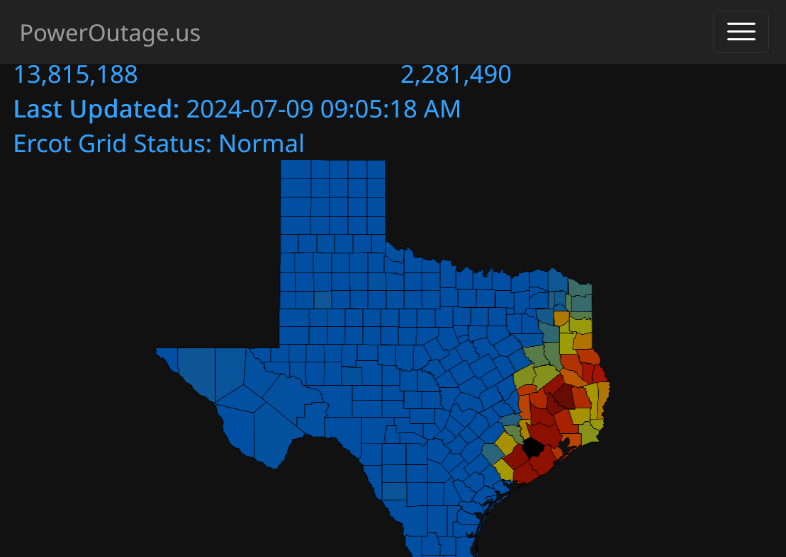
Power Outages:

Electric customers without power:
0+ 10k+(yellow) 50k+ 100k+(red)
| States and territories by customers out | |
| Texas | 2,281,490 |
| Louisiana | 18,967 |
| Arkansas | 14,243 |
| California | 8,922 |
| Pennsylvania | 5,945 |
| Last Updated: 2024-07-09 09:05:18 AM CDT | |
https://poweroutage.us/area/state/texas
LOWER MIDWEST
https://www.spc.noaa.gov/exper/mesoanalysis/new/viewsector.php?sector=20

https://www.spc.noaa.gov/exper/mesoanalysis/new/viewsector.php?sector=20#

https://www.spc.noaa.gov/exper/mesoanalysis/new/viewsector.php?sector=20# 
Current Hazards at the link below.
Go to the link below, hit hazards box in the top right hand corner(it will also define all the color codes), if its not already in the hazards mode when you load the link.
Then you can hit any spot on the map, including where you live and it will go to that NWS with all the comprehensive local weather information for that/your county.

Severe Storm Risk......updated daily(days 1 and 2 twice daily).
https://www.spc.noaa.gov/products/outlook/
Current Day 1 Outlook |
WE'VE ONLY GOTTEN 0.04 SINCE 11:00 THIS MORNING... & THE FORECAST FOR MORE, HAS DROPPED BY AN INCH. NOW, 1.50 IS THE FORECAST TOTAL. THE BULK COMING TONIGHT
I had said:
“A strengthening cat 1 like Beryl is often worse than a weakening cat 2 because the strong winds above the surface often mix down more efficiently in a strengthening TC.”
Mike asked “Where do you get this from?”
I responded:
“I learned this over the years from hanging out at wx BBs like American and Storm 2K and reading Joe Bastardi at Accuwx/WxBell. It has been mentioned several times this morning at both BBs and also yesterday by JB.”
———————-
More on this idea from Joe Bastardi yesterday:
“Beryl exposed the Saffir Simpson Scale Much like Idalia did but in the opposite way. The Power and Impact Scale far better correlated with the kind of damage it caused and it confirms the idea that when storms are intensifying their wind is likely to get down to the surface.”
Thanks, Larry!
Joe's a really smart guy and a hurricane expert but that doesn't appear to be what happened here. I showed the indisputable physics/meteorology of hurricanes based on their direction of movement.
I've seen this many dozens of times in the real world and of course that would be the case because its based on a physical law.
I always listen/read very credible opinions from others, some will always know things that I don't. Some, like Joe will know MUCH MORE than me about a particular topic. Then, I check to see if the physical laws and reality/observations back up those opinions as applied to specific cases....... and I go with the evidence/data.
Regardless, this is what I found/show. Not because I was looking for it or even thinking of it at first because the first thing I looked for and assumed was what Joe stated. When that didn't make sense in this case..........I expanded my search/look.
https://www.marketforum.com/forum/topic/105227/#105561
Regardless, I'm still wide open to the possibility of what Joe says is right here. I looked hard and objectively and can't find it. Maybe I'm not looking in the right places.
I would love to learn something new. Please help me.
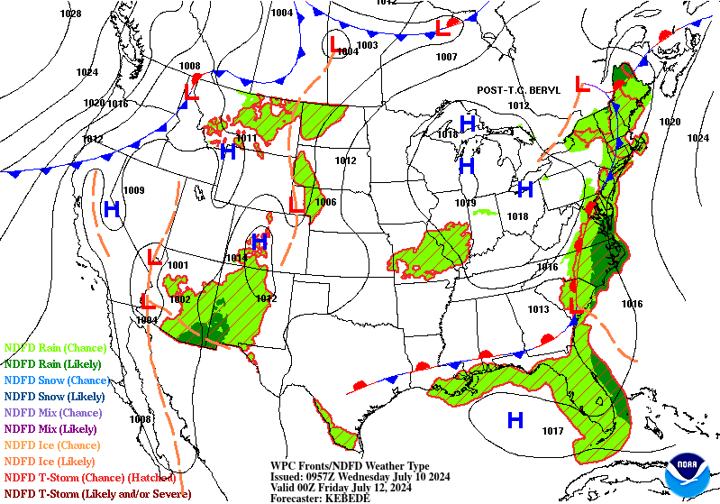
Last of Beryl is headed into Canada. Here's a snapshot, parting view with isobars/lines of constant pressure with the center over northwest Ohio, around Toledo:

This is the NWS surface forecast map for 2 hours from now, as the remnants cross into Southern Ontario.
https://www.wpc.ncep.noaa.gov/basicwx/basicwx_ndfd.php

There it is Thursday Evening as it tracks across the province of Quebec, barely west of Quebec City on this map.
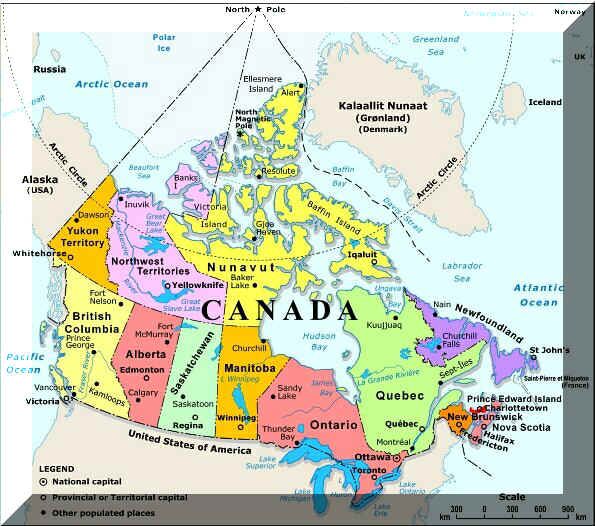
Not familiar with the provinces of Canada? Here's a great map to learn them.
Mike said:
“Joe's a smart guy but that doesn't appear to be what happened here. I showed the indisputable physics/meteorology of hurricanes based on their direction of movement. “
————-
Hey Mike,
We all agree that the dirty/right side vs direction of movement ~always has the highest sustained winds overall as it clearly did here due to the physics. But over and above that, the point is that this storm produced higher winds overall vs the avg 80 mph max wind (lower end cat 1) storm.
The 80 mph winds were for the winds rotating around the storm itself that DON'T count the winds with respect to the ground, which are lower on the left side and higher on the right side, which is where Houston was.
Add in the 17 mph from the speed of the hurricanes track and you get 97 actual winds from a system with 80 mph winds, right?
Also, hurricanes have STRONGER wind GUSTS above that sustained speed. This is expected.
I would like to see where this hurricane was actually strengthening over Houston and how that resulted in downward transport of higher winds aloft when its usually collapsing storms that feature more downward transport and strengthening storms more upward transport/rising motion from buyout air that feeds the strengthening.
I'm not saying that this doesn't happen but where is an actual measurement or data that suggests it happened here other than people saying it did?
Many times when they say 80 mph max winds the 80 mph are hard to find even in measured gusts on the dirty side. In this case not only were 80 mph gusts widespread on the dirty side, there were even some 90+ mph gusts seen with a peak gust of 97 mph (156 km/h) in Brazoria!
Thanks, Larry!
I get that this happened and downward transport of higher winds could have been a factor OR strengthening can be a factor when winds are higher than expected but my issue is with strengthening CAUSING the downward transport.
I'd like to know the physical process for that and the evidence of it.
WE WOUND UP WITH A TOTAL OF 1.09" OF RAIN.
Thanks, Jean.
we got over an inch but I’ll have to check the rain gauge.
larry,
I found a good study to support what you are saying and will share it when back in the office.
thanks for being persistent Or else I wouldn’t have learned something!
Hey Mike,
If you were to join one of the 2 wx BBs, you would likely be able to discuss downward transport of winds with fellow mets. Having a pro met tag typically generates good discussions with fellow mets as well as with knowledgeable amateurs. I know you've been reluctant to join though due to lack of free time, which I understand.
4+ inches here
Thanks a ton Larry and it would be great fun and as you can see, I already spend way too much time here as a labor of love and learning.
Even if that was not the case, I'm trying to spend as much time as possible with my 98 year old dad and during the chess season, have 5 schools that I teach chess at, take to tournaments and run a local tournament at.
I have 800 hours worth of videos from camcordering our children and grandchildren that I need to load on to a computer hard drive and label.
And our 5,000 square foot house needs hundreds of hours of work to get ready to sell in the near future.
Related to this:
When I graduated in 1981 from University of Michigan with a BS in Atmospheric and Oceanic Science, I applied at the Weather Channel and dozens of other tv stations around the country.
They hadn't actually aired yet but were hiring meteorologists to fill the many positions.
https://en.wikipedia.org/wiki/The_Weather_Channel
Sadly for me, they said they were only hiring meteorologists with on air experience and to apply after I'd acquired that.
Happily for me, they hired Dale Dakus who worked at "Weather Scene" for WLWT in Cincinnati, OH and that caused an opening to me in February 1982.
My biggest attributes for television have always been understanding and forecasting the weather with elite skill, having a mom that was a clone for Elizabeth Taylor (and as a younger guy, it caused me to be physically attractive) and tremendous enthusiasm that I shared with viewers.
I had to work very hard at verbal communication and I think getting my head bashed in with a tire iron on Easter morning 1976 caused some brain damage which impacts my ability to communicate as well as the best speaking tv meteorologists.
Anyways, I quickly moved from that 1st job to Chief meteorologist at WEHT in Evansville in September 1982.
https://www.youtube.com/watch?v=-w7_CLn8QSs
With a couple of years of tv experience under my belt, The Weather Channel wanted to hire me in late 1985.
In the past 4+ decades, I have never not loved every second analyzing weather models and talking about weather. Sharing the weather. Having a weather forecast bust was no fun of course, so outside of that. Working with dozens of other meteorologists who shared the same love and shared their understanding would have been heaven.
If I had still been single, I would have said yes immediately.
If I had still been single, I would have said yes immediately. But my newly wed wife's entire family lived here, she had a good job and a 6 year old daughter already in school with grandparents playing a key role in watching her after school.
So I picked my family over my job in 1985 and continued to pick my family over everything.
In 1993, I left the tv station and stayed home to raise our kids. My wife worked late and was out of town a lot so it worked great. I taught them how to read in pre school hooked on phonics, was the room "mom" in their classes. Was their soccer, basketball, baseball and chess coach. Den leader and adult leader in cub/boy scouts. Chess coach for their schools(which I still do today).
And at the same time, I discovered that I could use the weather to trade commodities for a living and make many times more money than I had as a tv meteorologist.
Life was great. I started with $2k in 1992 and made almost $900K!
Then Jon Corsine used all my money in a segregated personal account(illegally) to make a margin call on a HUGE speculative bond position that bankrupted MF Global and that account was locked out on October 31, 2011.
https://www.abi.org/feed-item/happy-halloween-from-mf-global
So I borrowed a bunch of money to open a new account at PFG Best, on the suggestion of Stimpy at MarketForum. As I was trading there, most of the money from MF Global gradually came back and I added it to the borrowed money at PFG.
Then in July 2012, THAT GUY bankrupted PFG but in that case, he left a massive hole which meant much of my money was not coming back.
So I lost borrowed money + the money that I got back from MF Global.
Then, I borrowed whatever I could for a small account at Iron Beam. At that point, I made a small amount of money for several years that I could not use to grow the account because we had some huge bills living in a huge house. So the account did NOT grow and the markets were light years different.
In the 1990s, I had a satelllite dish on our roof getting weather information the same time the NWS got their's and beat everybody in the market when it came to timing of weather trades.
I waited for the right set ups, loaded the boat and watched the account soar higher for the first decade+.
Then, the internet hit and everybody had the same information as fast as me. Even worse, in house models and meteorologists were beating me.
In the 90's, I would see the weather changes, put on the position immediately and wait for up to 30 minutes before the market reacted.
In the last 20 or so years, while i'm watching every model and every map update like a hawk, I will sometimes see the ng market react strongly FIRST, just before I get the information. Somebody(s) got the update before me.
Natural gas trading has also stopped acting very reliably in one direction like it used to. Larry stopped trading it because of that.
I haven't made a ton of money trading in over a decade now.
NG can still get huge weather driven moves but along the way, there will be massive spikes and gyrations against the move on the way up and down. Large speculative traders exploiting people attempts to reduce exposure with stops. They will push thru a bunch of stops below support/above resistance, then go right back to trading in the direction it should.
Sorry to get carried away on the last post.
After looking at these actually studies, I'll have to revert BACK to my original statement and question how stronger winds aloft would be increasingly transported downward in a strengthening cat. 1.
The studies I found relate to down dwelling IN THE OCEAN along the coast. NOT THE ATMOSPHERE. They do show it contributing to a strengthening hurricane for a DIFFERENT reason that I never knew about:
Here's the studies:
Coastal Downwelling Intensifies Landfalling Hurricanes
+++++++++++++++
https://www.sciencedirect.com/science/article/abs/pii/S027277142400057X
+++++++++++++++++
https://www.nature.com/articles/s41598-023-51016-0
+++++++++
For those that want to understand coastal down dwelling more:
https://en.wikipedia.org/wiki/Downwelling

+++++++++++++
https://rwu.pressbooks.pub/webboceanography/chapter/9-5-currents-upwelling-and-downwelling/