The NWS has a little something for all the grain traders tonight. A hot dry Midwest for the next 10 days, giving “baked beans” a whole new definition. Then a good wash after that, if there is anything left.
Thanks Jim.
Are you long???
go to the weather page to see all the week 1 rains ,please.
I closed out all my positions on Thursday. I have no dog in the fight now. But I am intrigues to see what happens.
I’m always lurking Mike,
Thanks, Jim!
I was driving back from Detroit and am home now.
These are the rain maps that I was referring too:
Beans are -10c at the moment after opening around -4C??
https://www.marketforum.com/forum/topic/83844/#83848
The latest 7 day precip forecasts are below.
Day 1 below:
http://www.wpc.ncep.noaa.gov/qpf/fill_94qwbg.gif?1526306199054

Day 2 below:
http://www.wpc.ncep.noaa.gov/qpf/fill_98qwbg.gif?1528293750112

Day 3 below:
http://www.wpc.ncep.noaa.gov/qpf/fill_99qwbg.gif?1528293842764

Days 4-5 below:
http://www.wpc.ncep.noaa.gov/qpf/95ep48iwbg_fill.gif?1526306162

Days 6-7 below:
http://www.wpc.ncep.noaa.gov/qpf/97ep48iwbg_fill.gif?1526306162

7 Day Total precipitation below:
http://www.wpc.ncep.noaa.govcdx /qpf/p168i.gif?1530796126

Happy August to you!
Severe storm reports this week. Very active for this time of year!!!
Storms tracking around the periphery of the heat ridge!
https://www.spc.noaa.gov/climo/reports/240801_rpts.html
So far today, 8-1-24/Thursday

7-31-24/Wednesday

7-30-24/Tuesday

7-29-24/Monday

7-28-24/Sunday

I think it is not an outrageous thought to think crop ratings could improve again this week. Over the last 2-3 weeks here in NE Ohio, we went from getting pretty dry, to dare I say, lush?
We have been getting some pretty good rains lately and the crops around here look healthy.
You are probably right, Jim!
Interesting, much of the Midwest is going into a dry period the next 10 days or so but it will also turn very cool by August standards in many of those areas. This is actually BEARISH for corn because it will slow down maturity and increasing kernel filling time that contributes towards larger kernels and higher yields.
It's the exact opposite of heat fill.
https://www.cpc.ncep.noaa.gov/products/predictions/610day/ | |
| 6 to 10 day outlooks | |
| Click below for information about how to read 6-10 day outlook maps Temperature Precipitation | |
| Click below for archives of past outlooks (data & graphics), historical analogs to todays forecast, and other formats of the 6-10 day outlooks ArchivesAnalogsLines-Only FormatGIS Data | |
Temperature Probability | |
Precipitation Probability | |
Here's our best thread for explaining and illustrating this principle:
Heat Fill for Corn
Started by metmike - July 14, 2023, 2:47 p.m.
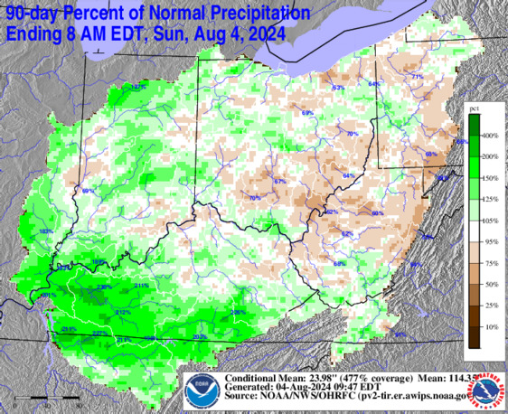
Here a great site for your neck of the woods, Jim!
It also includes jean, cutworm, mcfarm and metmike!!!
https://www.weather.gov/ohrfc/AccumPrecipDepart


These were the total 2 week rains from the drier 12z European model.
Areas in brown and especially yellow will see an inch or LESS during this period.
That's less 50% of the average. In some cases, maybe less than 25% in the yellow(and greens outside the cornbelt).
The Upper MIdwest will have robust rains!
Note the area in the Southeast with heavy rains.
Looks like the 5th shade of rain going up the scale to the right for the center band, along the Southeast Coast.
This would be 10+ inches of rain, most of why will fall from Debby this week.
