An African easterly wave (AEW) currently in the far E Atlantic could very well lead to the next Atlantic tropical cyclone (TC). It’s now on most of the 12Z models in some way, shape, or form along with being shown on a good number of ensemble members as a TC forming 8/31-9/3 mainly within 15-20N/45-60W moving WNW.
But for now, the NHC TWO still has this:
Tropical Weather Outlook
NWS National Hurricane Center Miami FL
200 PM EDT Mon Aug 26 2024

For the North Atlantic...Caribbean Sea and the Gulf of Mexico:

Tropical cyclone formation is not expected during the next 7 days.

$$
Forecaster Hagen/Pasch
https://www.kxan.com/weather/2024-tropical-timeline-tracker/
![]()
Tropical Cyclone Nameshttps://www.nhc.noaa.gov/aboutnames.shtmlNext up is Francine! |
There’s now a lemon, ladies and germs:
Central Tropical Atlantic:
An area of low pressure could form in the central portion of the
Tropical Atlantic in a few days. Thereafter, environmental
conditions appear generally favorable for some slow development of
this system by this weekend into early next week as it moves
westward to west-northwestward at 10 to 15 mph.
* Formation chance through 48 hours...low...near 0 percent.
* Formation chance through 7 days...low...20 percent.

You're on top of it as usual, Larry!
At 8AM, the NHC raised the 7 day chance of this becoming a TC from 20% to 40% based on much more aggressive model consensus at 0Z/6Z.
Still at 40% chance!
Hey Mike,
It briefly had peaked at 50% 7 day. The model consensus has cooled off quite a bit. I’d lower it to 0%/20% if I were in charge.
Thanks, Larry I didn't know it peaked at 50%!
A new wave in the Eastern Tropical Atlantic/off the coast of Africa bears watching, now at 40% chance of development the next 7 days.
https://www.nhc.noaa.gov/gtwo.php?basin=atlc&fdays=7

This is the time of year when the tropics should be coming alive with storms! The historical peak is around Sept. 10th:
https://www.trackthetropics.com/hurricane-season-statistics/


Another DUD!
https://www.nhc.noaa.gov/gtwo.php?basin=atlc&fdays=7

+++++++++++++++
By Mary Gilbert, CNN Meteorologist
Updated 12:53 PM EDT, Fri September 6, 2024
++++++++++++++++
CNN —
It’s early September – what should be the busiest stretch of hurricane season. Forecasters predicted this one was going to be bad: storm after storm, the most bullish forecasts on record.
Instead, the Atlantic Ocean is enveloped in a rare and strange calm that has flummoxed forecasters and reset their expectations. And the whole thing could be a glimpse at what’s to come as the planet gets hotter.
Despite ideal conditions that fueled pre-season predictions of upwards of 20 named storms, the immediate prospects for one are low, and none have formed in the Atlantic since Ernesto in mid-August – a streak unmatched in 56 years
Very warm conditions tied to the climate crisis both at Earth’s surface and higher up in the atmosphere are also limiting the available chaotic energy tropical systems need to form.
+++++++++++++++
This is one of the many things that happen when you over hype a fake climate crisis!
And how do they respond to the busting forecast for record tropical activity from the fake climate climate crisis?
I underlined it above:
They blame this on............the fake climate crisis!
So no matter what happens, if its not the climatological average, then the fake climate crisis caused it. Fact is the weather rarely hits the average for that day. The average consists of many extreme above averages and just as many extreme below averages and has ALWAYS been that way.
++++++++++++++++++++++++++
It really boils down to this, once again(Cliff Mass can be counted on as an elite source for using objective, authentic science)
https://cliffmass.blogspot.com/2016/03/the-golden-rule-of-climate-extremes.html
The GoldenRule
Considering the substantial confusion in the media about this critical issue, let me provide the GOLDENRULE OF CLIMATE EXTREMES. Here it is:
The more extreme a climate or weather record is, the greater the contribution of natural variability.
Or to put it a different way, the larger or more unusual an extreme, the higher proportion of the extreme is due to natural variability.
On Sep 2, I said:
“It briefly had peaked at 50% 7 day. The model consensus has cooled off quite a bit. I’d lower it to 0%/20% if I were in charge.”
—————
So, on Sep 2 when I posted that, it was at 0%/40%. It now looks like it (labeled as Invest 91L this morning) is likely to become a TC within a few days after all. So, whereas the NHC and I were on Sep 2 right about the 0% (48 hrs), I’m not sure I was right in thinking the 7 day should have then been lowered to 20% as that was through Sep 9 at the time and it may become a TD by then.
Interestingly though, the NHC ended up lowering the 7 day to 20% late on Sep 5.
My 1st post in here (12 days ago on 8/26) refers to most models/many ensemble members forming a TD from this 8/31-9/3 E of the Leewards. So, it ends up that it is going to form much later and much further W assuming it actually forms.
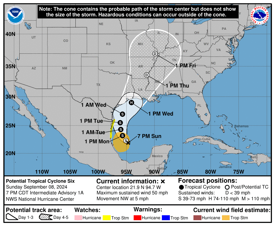
This is from the bullish brand new (7PM CDT Sep 7) TWO (some models turn this into a H that then landfalls in TX or LA):
Tropical Weather Outlook...Corrected
NWS National Hurricane Center Miami FL
800 PM EDT Sat Sep 7 2024

For the North Atlantic...Caribbean Sea and the Gulf of Mexico:

1. Western Gulf of Mexico (AL91):
An area of low pressure located over the Bay of Campeche is
producing disorganized showers and thunderstorms. This disturbance
is forecast to drift slowly northward during the next several days
while it interacts with a frontal boundary. Environmental conditions
are forecast to become more conducive for development, and a
tropical depression is likely to form while the system moves
generally northward near or along the Gulf coast of Mexico and Texas
through the middle of next week. Interests along the western Gulf of
Mexico coast should closely monitor the progress of this system.
* Formation chance through 48 hours...medium...60 percent.
* Formation chance through 7 days...high...80 percent.

Eric Snodgrass 8-6 at about 8-9 minutes. Artificial intelligence forecast.
Larry,
I wasn't commenting on anything that you've provided here, which always keeps us posted on the latest.
cutworm,
Great stuff by Eric, as always.
The last 12z European model is more bullish on rain chances here at the end of next week:
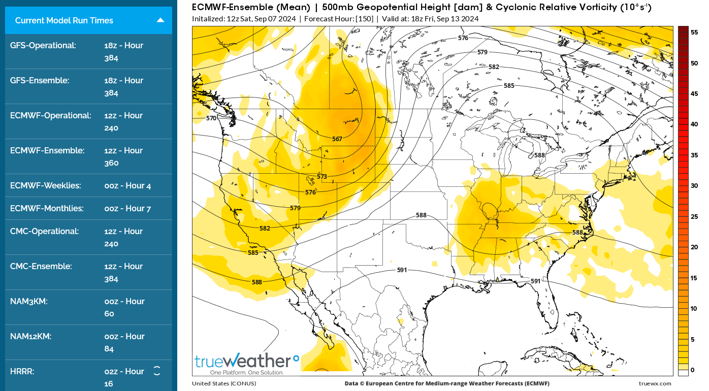
1. Previous 0z 500 mb forecast for the end of this week.
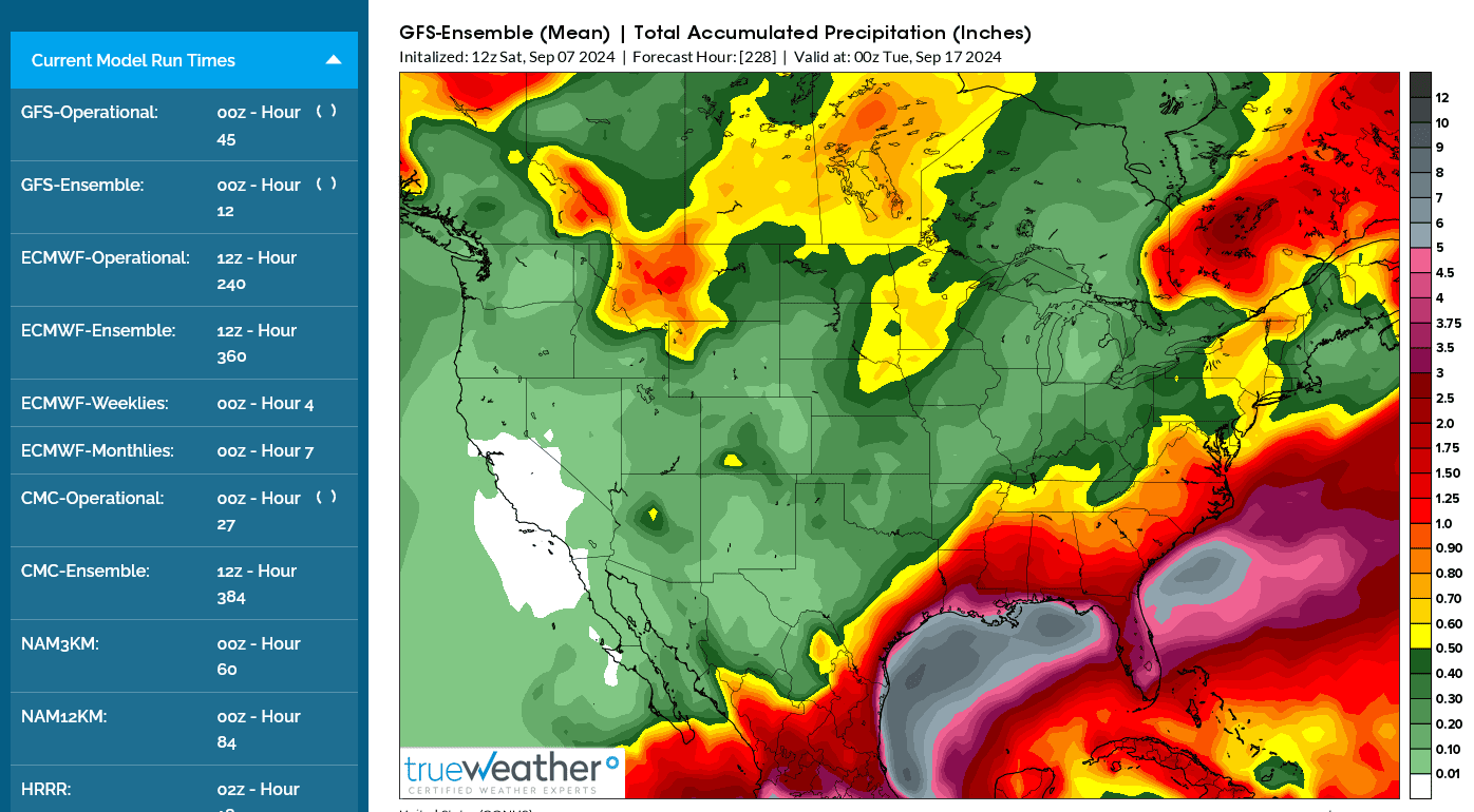
2. Followed by total rains thru 9 days. for that model from 12 hours ago.
+++++++++++++++++++
3. Last Euro 500 mb forecast for the end of the week. Vorticity pattern is farther north with a small cut off low in extreme southern IL.
4. Rains thru 9 days MUCH farther north by 200+ miles, almost from Indianapolis to Dayton, OH line.


+++++++++++++++++++++++++
12z data from the European model

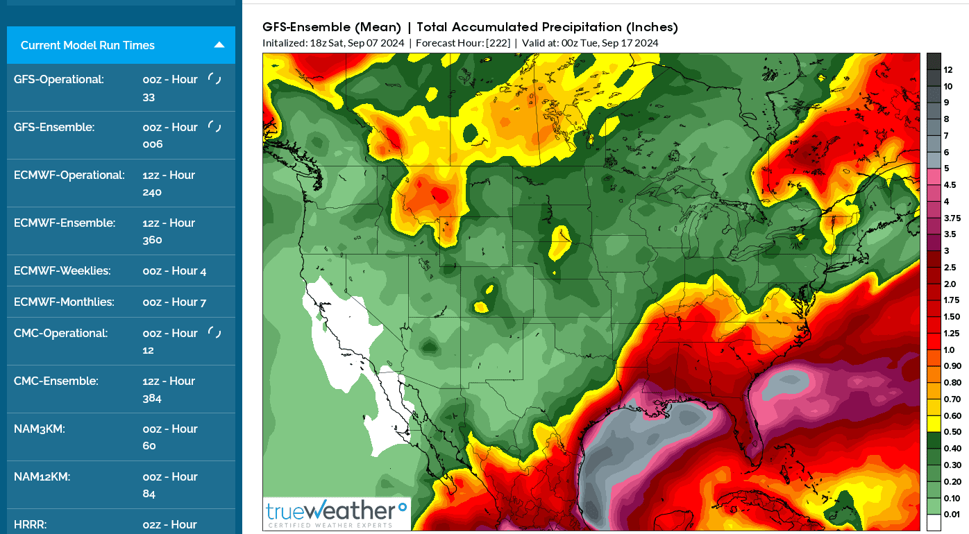
We now have the forecast reasoning to justify making the forecast much wetter at the end of this upcoming week. The Canadian model is even farther north and the last 18z GEFS, for the first time has moved towards this solution..
5. 12z Canadian model
6. GEFS 12z run
7. 18z GEFS model. Rains MUCH farther north.
+++++++++++++++++++++++
6. GEFS 12z run
7. Last GEFS 18z run. Rains much farther north.
Things can move back in the other direction/south again but this is potentially good news to help with the flash drought in the Ohio Valley
Hey Mike, thanks. Yeah, I know. I was recapping my earlier posts in here and showing how much the “thinking” of the models/NHC/me on this wave changed since 8/26. The tropics are extra fascinating due to the unpredictability factor, which sometimes is large like in this case when it looked like it may become a TD ~a week ago/2K miles to the E!
Cutworm, I watched that Eric Snodgrass video discussing the possibilities about this system. And I read Mike’s scenarios for the Midwest. Thanks for posting those.
Interesting as what starts in the tropics often has a huge effect in portions of the U.S. So, the ultimate strength/path/rainfall pattern from this is still so far up in the air as its major rainfall effects could very well not end before next weekend.
Models are less bullish on the northern extend of rains in a week but the NWS is picking up on it at towards the end of their 7 day forecast now.
7 Day Total precipitation below:
http://www.wpc.ncep.noaa.govcdx /qpf/p168i.gif?1530796126

Back in the tropics, we're watching the system in the Western GOM to see if it can make a named storm before leaving the warm waters.
https://www.nhc.noaa.gov/gtwo.php?basin=atlc&fdays=7
+++++++++++
https://en.wikipedia.org/wiki/2024_Atlantic_hurricane_season
For a chronological guide, see Timeline of the 2024 Atlantic hurricane season.

No doubt the season to date has been much less active in the basin as a whole to this point. The most aggressive forecasts are almost surely going to bust quite badly.
Nevertheless, we still have a long ways to go. Furthermore, if Invest 91L (now PTC 6 by the way and now forecasted to hit LA as a H) were to hit the CONUS as a H by early on 9/12, it wouod be the 3rd US H hit and that would be earlier than ~94% of seasons since 1851 per records! The only earlier ones: 2020, 2005, 2004, 1985, 1934, 1933, 1916, 1893, 1896, 1879, and 1871.
**Edited for error: I left out that I was referring to how early in the season it would be if this hits the US as a H.
I’m having a tough time today with my errors in posting. And I’m not drunk! Maybe I should take the rest of the night off lol.
In 4+ decades as a meteorologist, I've never been this excited about the potential for the remnants of a tropical system, Francine to hit us!!!!!!
Potential for 2 inches of rain to take us out of one of the driest 5+ weeks in history for Evansville, IN.
.05 in our rain gauge since August 1st.
https://www.nhc.noaa.gov/refresh/graphics_at1+shtml/213729.shtml?cone#contents
This was the rain forecast from the just out 18z GEFS, by far the most bullish yet for rains here!!!
500 mb heights Friday Noon

This is the 300mb jet stream level from the last 18z GFS run. The remnants of soon to be TS and maybe minimal Hurricane Francine may actually get trapped(or move extremely slow) for a short while close to the Ohio River, with the main jet stream farther northwest and an upper level high to the north.

18z GEFS total rains the next 8 days below. Light blue = 2+ inches up to the Ohio River! Yippee!

https://www.marketforum.com/forum/topic/83844/#83848
7 Day Total precipitation below: NWS
http://www.wpc.ncep.noaa.govcdx /qpf/p168i.gif?1530796126
I carelessly left off in my prior post, which I just corrected, that I was referring to how early would be the 3rd H hit on the US if PTC-6 were to do so. I’m having a tough time today with my errors in posting. And I’m not drunk! Maybe I should take the rest of the night off lol.
Larry,
I'm glad you just elaborated on that because I noticed it but thought it might be me.
Join the club on typing mistakes. I make 1 or more on almost every post it seems like and am getting worse. In fact, I just fixed a huge mistake from my previous post! Posting from a phone or Ipad makes it much worse.
Seriously! I think that, in my case there's been some minor cognitive losses that mainly impact my typing skills, probably related to my excessive drinking and being knocked out several times in bar fights almost 50 years ago.
I just remembered that one of those times was very early Easter morning 1976 when I got my head bashed in with a tire iron and had some cognitive adversity for several months after that.
As well as having Ehlers Danlos and a Lupus like autoimmune disorder the requires a couple of meds that have minor cognitive side effects.
You are greatly appreciated, especially since you aren't perfect!


Thanks, Mike!
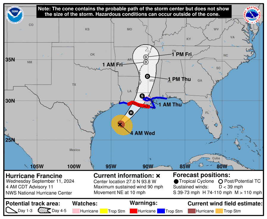
Per this, Francine is about to be designated:
AL, 06, 2024090912, , BEST, 0, 227N, 947W, 45, 1002, TS, 34, NEQ, 40, 100, 140, 140, 1008, 180, 70, 0, 0, L, 0, , 0, 0, FRANCINE, S, 0, , 0, 0, 0, 0, genesis-num, 014,
Thanks, Larry!
Water temps close to 30 Deg. C which is around 86 Deg. F are plenty warm for rapid strengthening but other atmospheric factors are at play. This is the biggest reason for the quiet tropics this month. The atmosphere has been UNfavorable for tropical systems.
However, Francine will have a potential period of rapid strengthening.
https://www.ospo.noaa.gov/data/sst/contour/usatlant.fc.gif

++++++++++++++
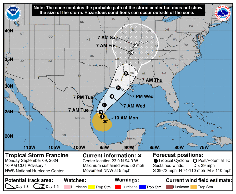
Exactly as Larry told us, we just dubbed this tropical depression a tropical storm, named Francine, the 6th named storm so far in the 2024 tropical season.
https://www.nhc.noaa.gov/refresh/graphics_at1+shtml/095139.shtml?cone#contents
WTNT31 KNHC 091455
TCPAT1
BULLETIN
Tropical Storm Francine Advisory Number 4
NWS National Hurricane Center Miami FL AL062024
1000 AM CDT Mon Sep 09 2024
...DISTURBANCE BECOMES TROPICAL STORM FRANCINE...
...EXPECTED TO INTENSIFY WITH STORM SURGE AND HURRICANE WATCHES
ISSUED FOR THE LOUISIANA COAST...
SUMMARY OF 1000 AM CDT...1500 UTC...INFORMATION
-----------------------------------------------
LOCATION...23.0N 94.9W
ABOUT 245 MI...395 KM SE OF MOUTH OF THE RIO GRANDE
ABOUT 480 MI...770 KM SSW OF CAMERON LOUISIANA
MAXIMUM SUSTAINED WINDS...50 MPH...85 KM/H
PRESENT MOVEMENT...NNW OR 340 DEGREES AT 5 MPH...7 KM/H
MINIMUM CENTRAL PRESSURE...1002 MB...29.59 INCHES
WATCHES AND WARNINGS
--------------------
CHANGES WITH THIS ADVISORY:
A Storm Surge Watch has been issued from east of High Island,
Texas, eastward to the Mississippi/Alabama Border, including
Vermilion Bay, Lake Maurepas, and Lake Pontchartrain.
A Hurricane Watch has been issued from Cameron eastward to Grand
Isle in Louisiana.
A Tropical Storm Watch has been issued east of High Island, Texas,
to Cameron, Louisiana, and from Grand Isle, Louisiana, to the Mouth
of the Pearl River including Lake Pontchartrain and Lake Maurepas.
Thanks, Larry!
Winds are predicted to hit 85 mph now, with a period of rapid intensification likely from the very warm ocean water.
https://www.nhc.noaa.gov/text/refresh/MIATCDAT1+shtml/091459.shtml?
The SHIPS rapid intensification (RI) indices are pretty elevated, and a period of RI could also occur between 24-48 h. For now, the NHC intensity forecast will not explicitly forecast RI, but is higher than the previous cycle and shows a 75 kt peak in 48 h, in good agreement with the intensity consensus aids. After that period, southwesterly vertical wind shear quickly increases from 10 kt to more than 30 kt and the intensity could plateau as it approaches the northwestern U.S. Gulf coastline, though the system is forecast to remain a hurricane at landfall.
This hurricane will be strengthening as it approaches the coast.
I remember our discussion about this with Beryl!
Re: Invest 95L headed to Caribbean: could become Beryl before
By WxFollower - July 8, 2024, 10:27 a.m.
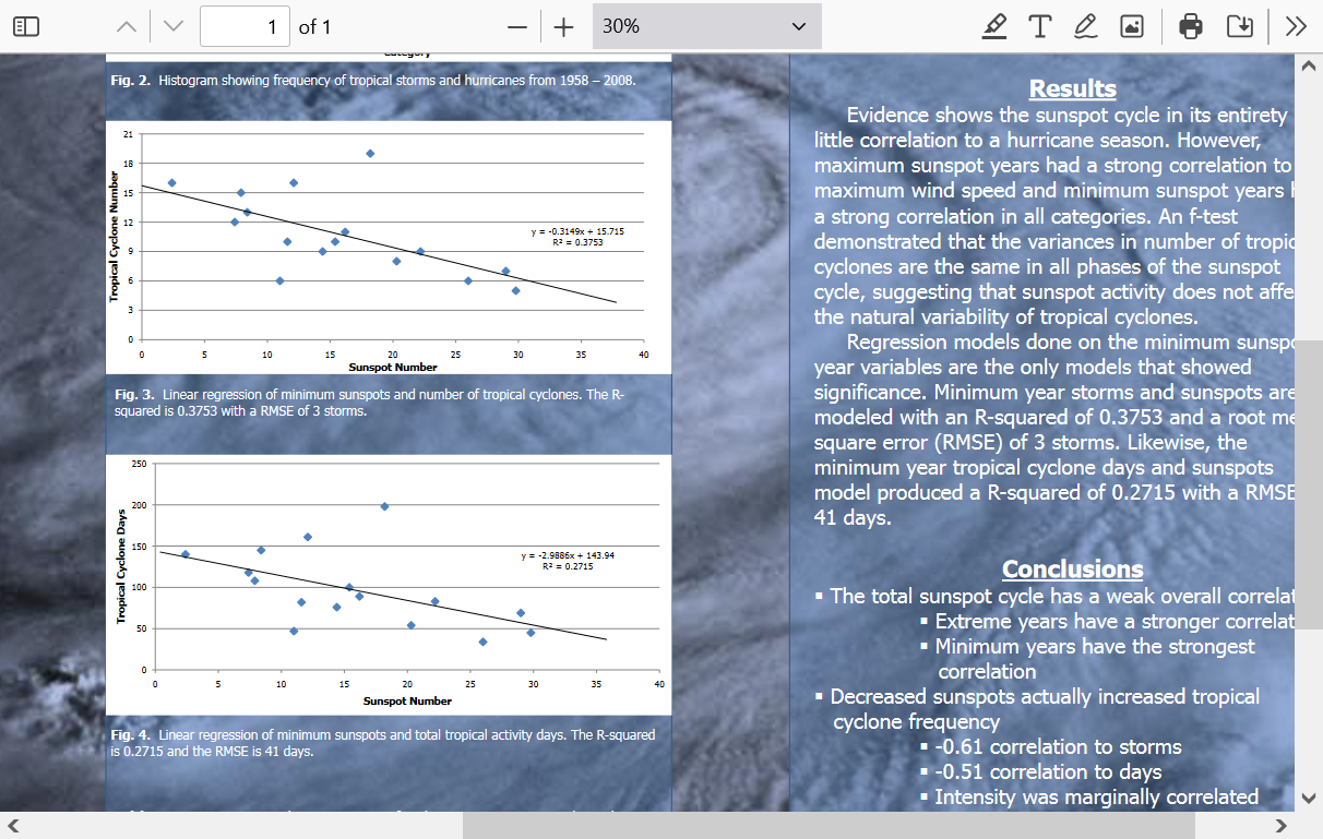
Below are the daily sunspot #s for Sept MTD. Despite still high, there’s been a modest trend downward. To compare, Aug was way up at 215, the highest in Aug of the modern active era.
There is support from many papers written since 2008 suggesting a partial negative correlation between sunspot #s and overall Atlantic tropical activity. The idea is that the upper troposphere and lower stratosphere are quickly warmed more than below when the sun is more active. This results in increased atmospheric stability, which is less conducive to tropical convection. I wouldn’t consider the connection proven, but I’m open-minded about it.
One of the theories being circulated about the very quiet late Aug/early Sep is the very high sunspot #s likely being one of the major contributors to the quiet. With Francine today being designated along with the MDR having increased convection, I do wonder if there could be a partial connection to the very recent moderate reduction in solar activity. Even if there is, the sunspot levels could quickly rise back one day soon:
2024 09 01 2024.668 182 14.5 27 35
2024 09 02 2024.671 195 21.1 25 32
2024 09 03 2024.673 179 22.2 20 23
2024 09 04 2024.676 174 26.1 21 26
2024 09 05 2024.679 181 13.1 15 20
2024 09 06 2024.682 189 13.3 19 24
2024 09 07 2024.684 167 17.4 21 25
2024 09 08 2024.687 173 17.3 17 22
2024 09 09 2024.690 158 21.2 17 18
Thanks for showing me something new to investigate, Larry!
Sunspot Activity and Atlantic Tropical Cyclones
BRIAN HUTTON JR.
Department of Geosciences, Mississippi State University; Mississippi State, Mississipp
file:///C:/Users/Basement/Downloads/160259.pdf
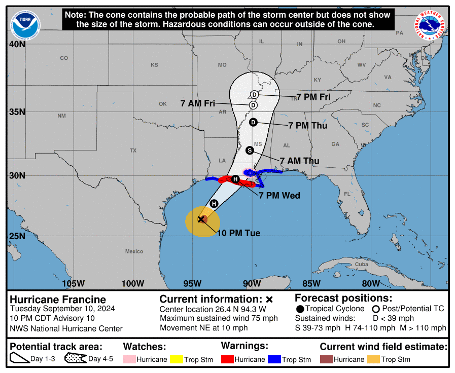
Francine updated forecast to a cat. 2, 100 mph hurricane on Wednesday.
https://www.nhc.noaa.gov/text/refresh/MIATCDAT1+shtml/092053.shtml?
https://www.nhc.noaa.gov/refresh/graphics_at1+shtml/212929.shtml?cone#contents

Another 24 hours of strengthening, potentially to 90 mph based on the last NHC forecast, before Francine hits the coast and rapidly weakens.
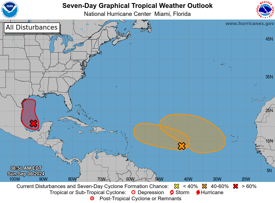
we have a new disturbance in the eastern tropical Atlantic today with an 80% chance of developing, within the next 7 days.
We are right at the climatological peak for tropical activity and in many years, have several named storms in the Atlantic at the same time in mid September.
TS Francine will likely be a hurricane in 12 hours.
With just enough time left to maybe strengthen to 90 mph tomorrow over the very warm waters of the Western GOM before hitting land.
https://www.nhc.noaa.gov/text/refresh/MIATCDAT1+shtml/102038.shtml?
TRACKING FRANCINE! Most maps are updated every few minutes but you might need to hit the link.
https://www.spc.noaa.gov/exper/mesoanalysis/new/viewsector.php?sector=15#
|
https://www.spc.noaa.gov/exper/mesoanalysis/new/viewsector.php?sector=15#
https://interactive.wfaa.com/wximages/wfaa-gulf.html
 |
+++++++++++++++++++
 NOAA Satellites@NOAASatellites
This 18 seconds of imagery from
's #GOESEast satellite shows the evolution of #Francine in the Gulf of Mexico over the last two days. #TimelapseTuesday Latest: http://noaa.gov/francine
Hurricane Francine Forecast Discussion
https://www.nhc.noaa.gov/text/refresh/MIATCDAT1+shtml/092053.shtml?
https://www.nhc.noaa.gov/refresh/graphics_at1+shtml/032528.shtml?cone#contents
Weakens earlier now and doesn't go as far north. Hopefully, still BARELY bringing nice rains to Evansville, IN but not as promising for rains along and especially north of the Ohio River.
Below was the forecast 24 hours ago.
Francine at 90 mph, headed to 100 mph today then hitting land. Forecast is for rapid weakening headed north. Weaker and less far north again early this morning. Good rains just barely getting to southern IN. Close call.
https://www.nhc.noaa.gov/text/refresh/MIATCDAT1+shtml/110855.shtml?
https://www.nhc.noaa.gov/refresh/graphics_at1+shtml/092734.shtml?cone#contents
Noon: Francine peaked at 90 mph. Not much change to the forecast. Close call for the desperately needed moisture to barely get north of the Ohio River.
At the surface, the Right side of the hurricane will have winds of 16 mph HIGHER than the winds circulating around the hurricane Because the flow on the right side is in the same direction as the forward speed.
the forward movement of Francine is 16 mph. This applies to all low pressure systems With their counterclockwise flow in the northern hemisphere.
its in the opposite direction in the southern hemisphere.
So a 60 wind around Francine can become a 76 mph wind at the surface on the right side.
https://www.unidata.ucar.edu/data/NGCS/lobjects/chp/structure/

Here's another graphic depicting that principle:

Fixed my mistakes above!
Francine ended up peaking at 100 mph (cat 2) just before landfall in LA. New Orleans got a pretty solid hit from this.
Thanks, Larry!
Francine is rapidly weakening and raining out much of the tropical moisture.


