Mike, please move this to TR. Thanks.
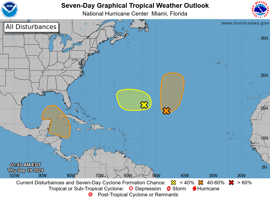
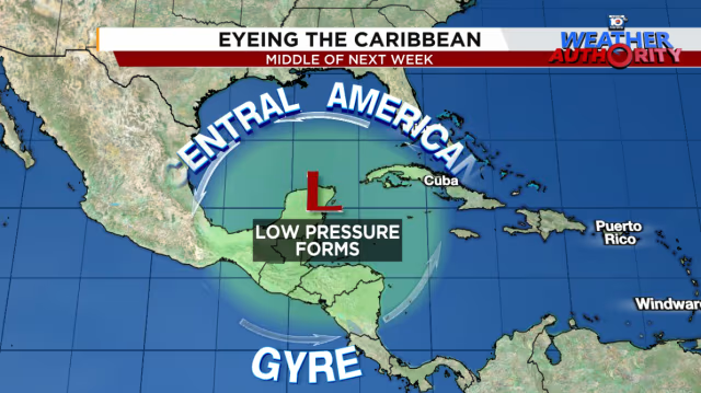
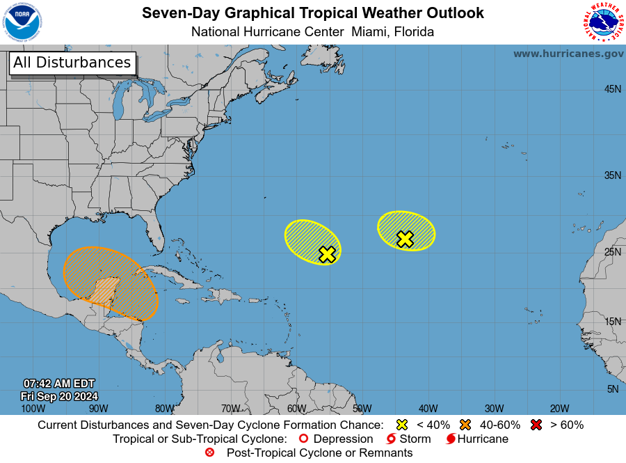
This one could threaten the US Gulf
coast as early as a week from now:

3. Northwestern Caribbean Sea and Southeastern Gulf of Mexico:
A broad area of low pressure could form late this weekend or early
next week over the western and northwestern Caribbean Sea.
Thereafter, gradual development of this system is possible, and a
tropical depression could form as the system moves slowly to the
north or northwest over the northwestern Caribbean Sea and into the
southeastern Gulf of Mexico through the middle part of next week.
* Formation chance through 48 hours...low...near 0 percent.
* Formation chance through 7 days...medium...40 percent.
Thanks a ton, Larry!
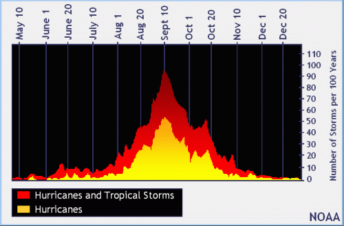
We've now passed what has historically been the peak in the tropical weather season.
It can still get very active, especially with record warm ocean water temperatures but not enough for this season to catch up to the forecast for the most extremely active tropical weather season ever.
In fact, we are on course(that can change) to have the biggest Atlantic basin tropical storm forecast season bust in history by and extremely wide margin.
Here's the link to your graphic/statment:
Previous tropical weather thread:
It's crazy that Larry started that one for us over 3 weeks ago when in most years, this is the most active time for tropical storms/hurricanes.
AEW in E ATL could be next TC
36 responses |
Started by WxFollower - Aug. 26, 2024, 2:27 p.m.
https://www.marketforum.com/forum/topic/106966/
+++++++++++++++++++++
https://www.kxan.com/weather/2024-tropical-timeline-tracker/
![]()
We're over a week past the climatological peak of September 10th.
However there have been MANY major hurricanes, well into October but with time, a month+ from now, that late in the hurricane season the bigger ones shift farther and farther south where the warmer water is.
https://www.trackthetropics.com/hurricane-season-statistics/
0Z:
Euro: E of 12Z, which had hit Mobile 9/29 at 989; 0Z hits Apalachicola 9/29 at 984 mb
GFS: just SE of Panama City late 9/27 at 979
CMC: E LA 9/27 981
ICON: C Gulf moving N 965 9/28
UK: 200 miles SSW of LA/TX border 1000 mb moving NNW late 9/27
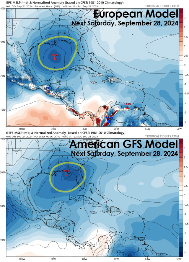
0Z Icon/GFS have major H hit on FL Big Bend. Damage would likely go well inland if that occurs.
Thanks, Larry!
NHC up to 70%.
I’ll be in Detroit for my 50 year high school reunion next weekend and on rhe road for an extended period.
very warm waters and rapid intensification are a possibility if other conditions are favorable.
the atmosphere is in La Niña mode even before the official La Niña is declared using lagging, 3 month averages of tropical pacific water temps.
so maybe reduced wind shear.
Up to 80% chance now.
Named Storms
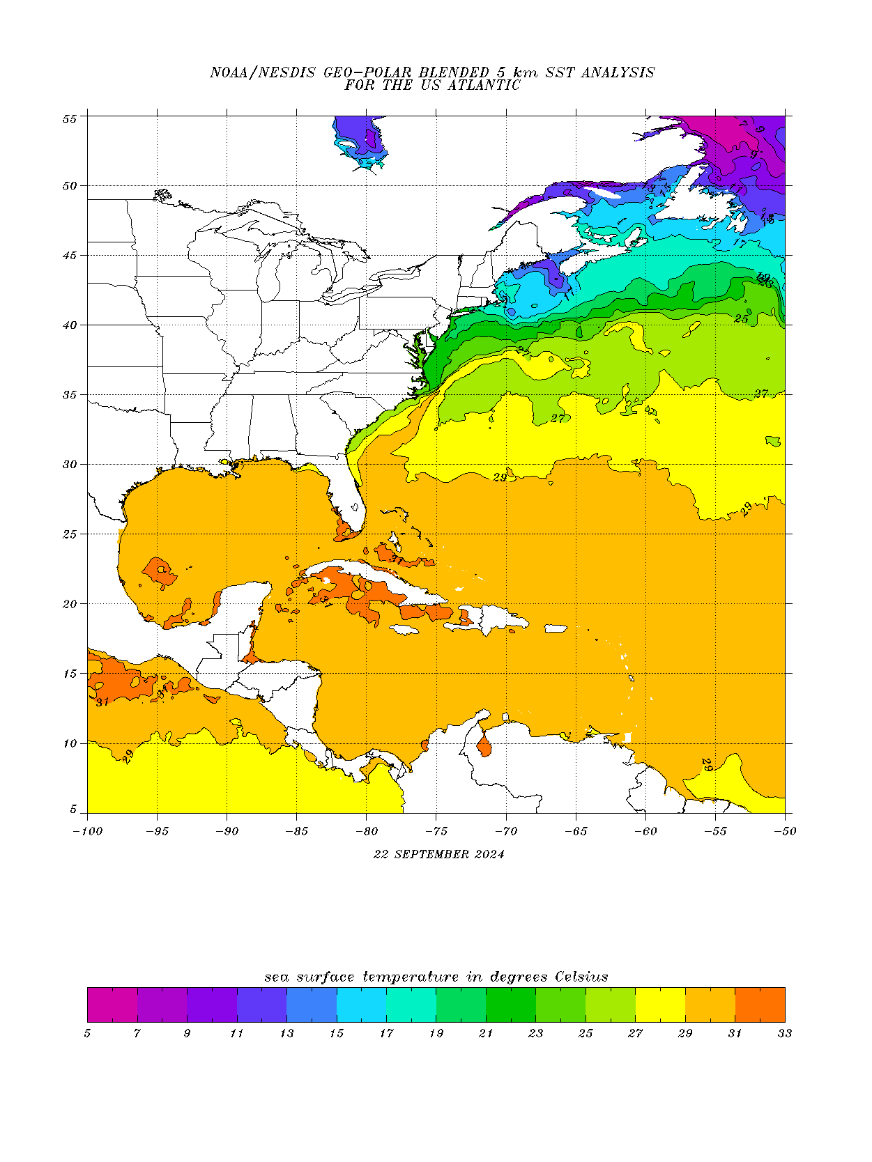
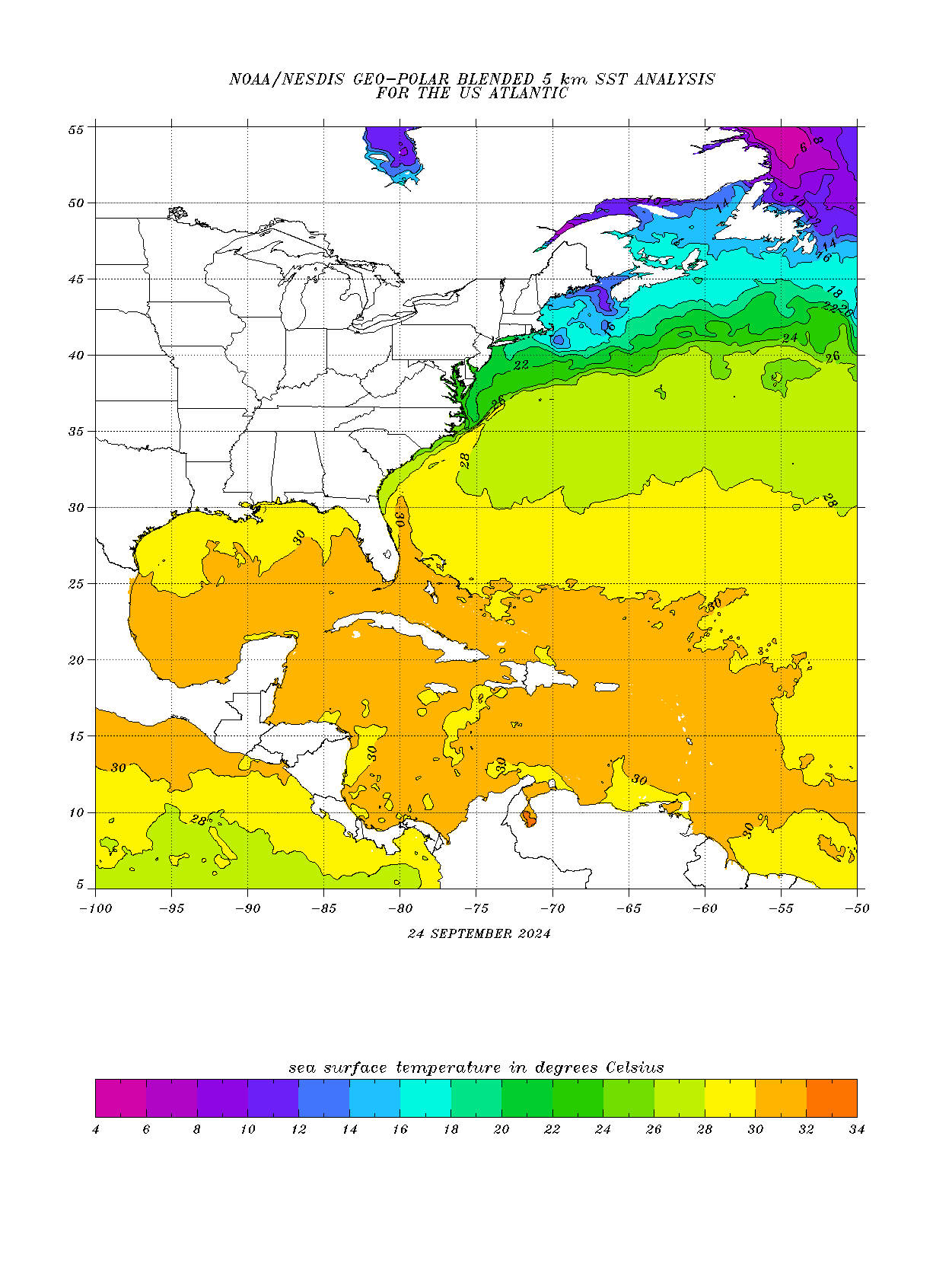
Pretty decent ocean heat content for Helene that could result in rapid strengthening before hitting the Gulf Coast. A hurricane need a minimum temperature of: 26 Deg. C= ~79 Deg. F
29 Deg. C = ~84 Deg. F The entire GOM is at least that warm
30 Deg. C = ~86 Deg. F There are some pockets in the GOM that warm.
These warm waters go pretty deep which means hurricane churning won't be able to pull up cooler water that can help limit a hurricanes strengthening.
https://www.ospo.noaa.gov/data/sst/contour/usatlant.fc.gif
No changes this morning, except models slow it down a tad. Maybe a cat. 3 with 115 mph winds at peak intensity.
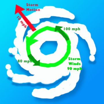
Currently moving at 30 knots or almost 35 mph, which is really moving for a topical system in the GOM.
This WILL mean the effect below will be even more amplified on the right side of this hurricane, which will see the forward speed ADDED to the hurricane's wind circulation speed.
At the surface, the Right side of the hurricane will have winds of 30+ mph HIGHER than the winds circulating around the hurricane Because the flow on the right side is in the same direction as the forward speed.
the forward movement of Helene is 35 mph. This applies to all low pressure systems With their counterclockwise flow in the northern hemisphere.
its in the opposite direction in the southern hemisphere.
So a 90 mph wind around Helene can become a 125 mph wind at the surface on the right side if it were still traveling that fast at landfall. Frictional forces closest to the ground will, as always quickly become a drag on the strongest winds.
https://www.unidata.ucar.edu/data/NGCS/lobjects/chp/structure/

Here's another graphic depicting that principle:
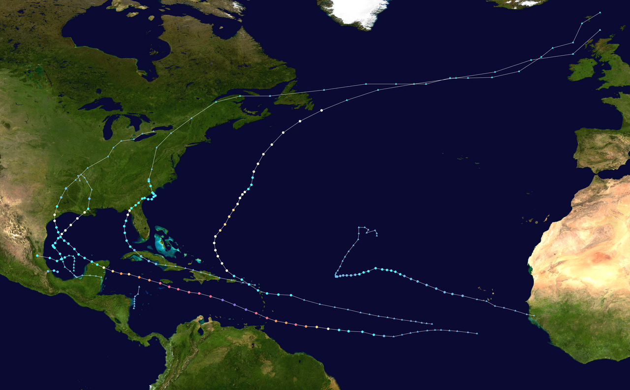
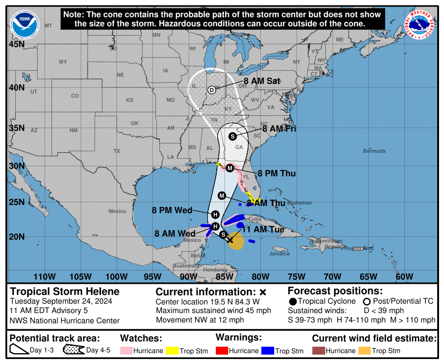
Hello Tropical Storm Helene, soon to be Hurricane Helene!
Thanks to Larry for tipping us off about this storm last week!
The size of this hurricane will be very large. Ocean heat content is very high, supporting RAPID intensification if other conditions remain optimal and Helene could be a MAJOR hurricane in 48 hours.
noaa.gov/refresh/graphics_at4+shtml/154152.shtml?3-daynl
https://www.nhc.noaa.gov/text/refresh/MIATCDAT4+shtml/241459.shtml?
https://www.nhc.noaa.gov/refresh/graphics_at4+shtml/154152.shtml?cone#contents
Currently at 60 mph. Should be a hurricane on Wednesday morning.
Top strength at 120 mph on Thursday evening!
https://www.nhc.noaa.gov/text/refresh/MIATCDAT4+shtml/250256.shtml?
https://www.nhc.noaa.gov/refresh/graphics_at4+shtml/213745.shtml?cone#contents
Hello Hurricane Helene! 80+ mph. Forecast to 125 mph late Thursday.
https://www.nhc.noaa.gov/text/refresh/MIATCDAT4+shtml/251457.shtml?
https://www.nhc.noaa.gov/refresh/graphics_at4+shtml/152934.shtml?cone#contents
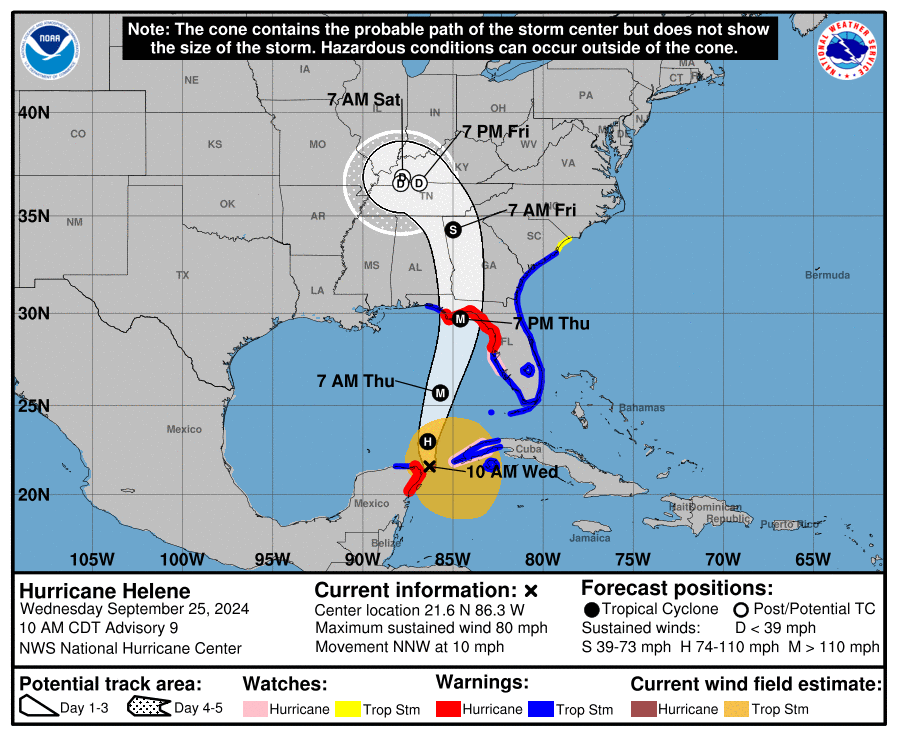
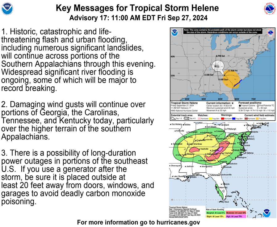
Helene is expected to move through/over an environment of relatively low shear, strong upper-level divergence, and sea surface temperatures of 29-31 degrees Celsius, all of which should foster additional strengthening. Rapid Intensification (RI) indices indicate a high chance of RI during the next 24 hours, and as a result the NHC intensity forecast shows Helene becoming a major hurricane by Thursday morning.
29-31 Deg. C = 84-88 Deg. F
These are the temps of the water that the NHC stated are along the path of Helene.
To be a hurricane, we need 79 Deg. F. Temps that are as warm as they are now, will be favorable for rapid intensification if all the other factors are ideal..........and they appear to be.
https://www.ospo.noaa.gov/data/sst/contour/usatlant.fc.gif
The right side of this hurricane(right front quadrant) is going to see winds increased by the forward speed of Helene which is around 11 mph. On the same side, the water will be piling up to create the greatest storm surge. It's why this side is referred to as the "DIRTY SIDE" of the hurricane.
The illustration below is for any hurricane and extremely coincidental to the location close to Helene
https://www.unidata.ucar.edu/data/NGCS/lobjects/chp/structure/
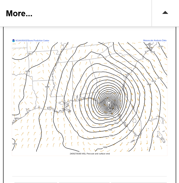
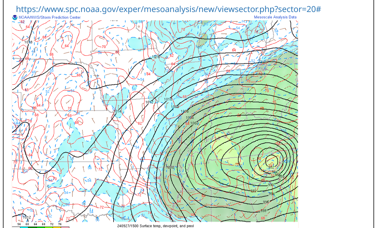
We can start tracking the northern fringe of the hurricane. This will get very impressive the next 24+ hours. Hoping I have the link that updates every 6 minutes. If not, you can hit the link for the latest.
https://www.spc.noaa.gov/exper/mesoanalysis/new/viewsector.php?sector=18

This was Hurricane Helene (frozen image) about to make landfall in the Big Bend area shortly after 11:30 pm EDT. Winds were 140 mph!
Up to 85+ mph. Ocean temps up around 86 degrees, so rapid intensification likely. Peaking at ~130 mph around tomorrow at this time.
Helene at 90+ mph.
115+ mph later today.
The spacing in the isobars is so close that the lines are really packed together! 105 MPH+ right now.
https://www.marketforum.com/forum/topic/107518/#107683
++++++++++++++++
EXCELLENT LIVE SOURCE RYAN HALL Y'ALL:
https://www.youtube.com/watch?v=XTnlp7qrTYg
https://www.npr.org/2024/09/26/g-s1-24643/hurricane-helene-tallahassee-tampa-atlanta-florida-georgia
Winds at 125 mph at 4pm Central. Movement is at 24 mph, so areas on the right side of the hurricane will see that speed added to the winds. There should be several hours of additional strengthening.
https://www.nhc.noaa.gov/text/refresh/MIATCDAT4+shtml/262043.shtml?
Data updated every 6 minutes.
https://www.marketforum.com/forum/topic/107518/#107683
This was Hurricane Helene (frozen image) about to make landfall in the Big Bend area shortly after 11:30 pm EDT. Winds were 140 mph!

Snapshot of the remnants of Helene just after 10am on Saturday:
You can get the most updated versions by going here:
https://www.marketforum.com/forum/topic/83844/#83845
++++++++++++++++++++
https://www.wunderground.com/maps/wind/current-winds

++++++++++++++++
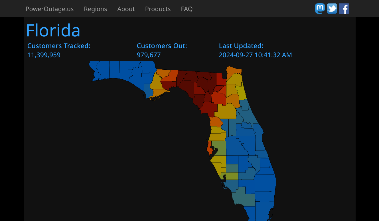
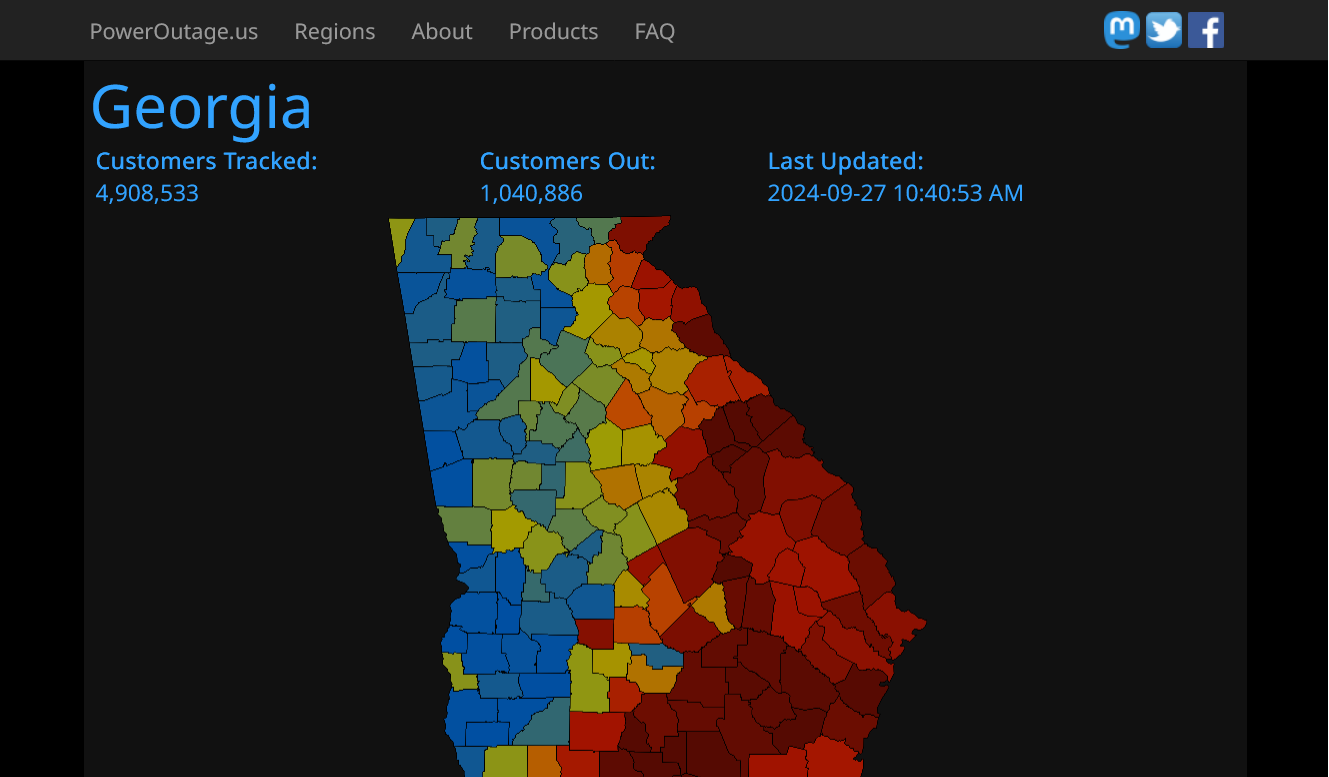
Go to the link/map below and you can hit the individual states to see a breakdown for the individual counties in that state.
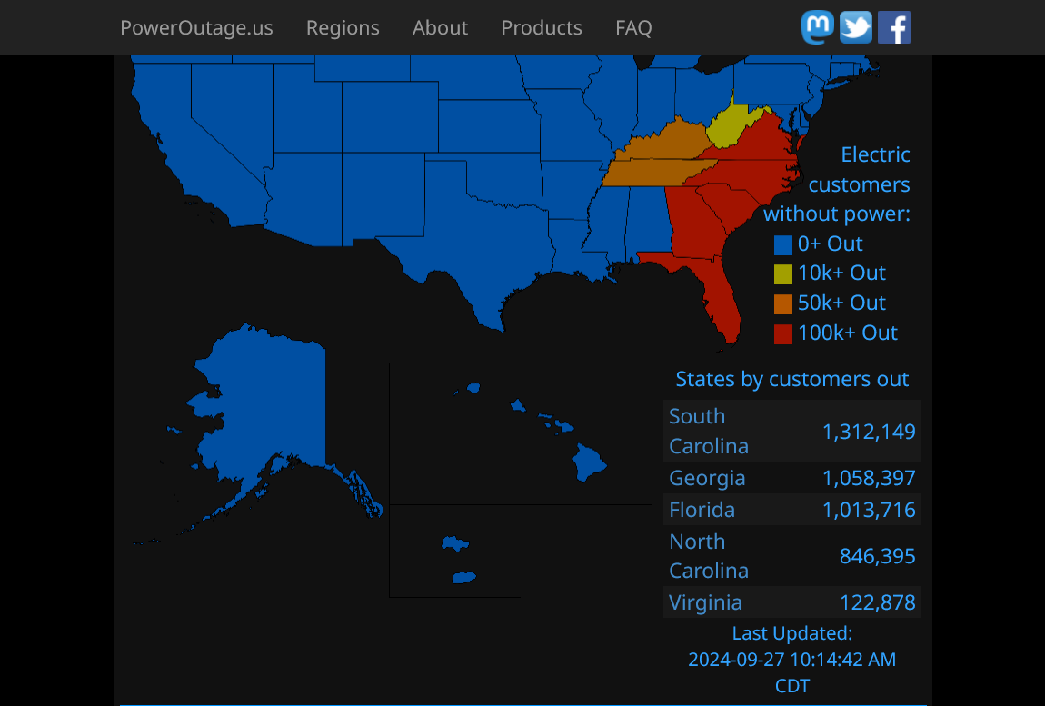
Below these maps, you will find an updated, exact number for each individual country!!
Helene down to 45 mph and becoming extratropical.
https://www.nhc.noaa.gov/text/refresh/MIATCDAT4+shtml/271436.shtml?
https://www.nhc.noaa.gov/graphics_at4.shtml?start#contents
Back from Detroit!
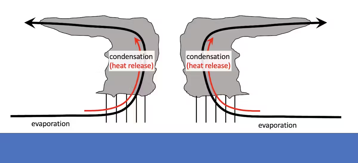
The temperature of both the ocean and atmosphere are critical to hurricane development.
Hurricanes are powered by the release of heat when water that evaporates from the ocean’s surface condenses into the storm’s rain.
A warmer ocean produces more evaporation, which means more water is available to the atmosphere. A warmer atmosphere can hold more water, which allows more rain. More rain means more heat is released, and more heat released means stronger winds.
+++++++++++++
metmike: An increase in temperature of 1 Deg. C (almost 2 Deg. F) allows the atmosphere to hold 7% more moisture. Which would equate to a potential for 7% heaver rains. 10.0 inches of rain can become 10.7 inches of rain, all other things being equal.
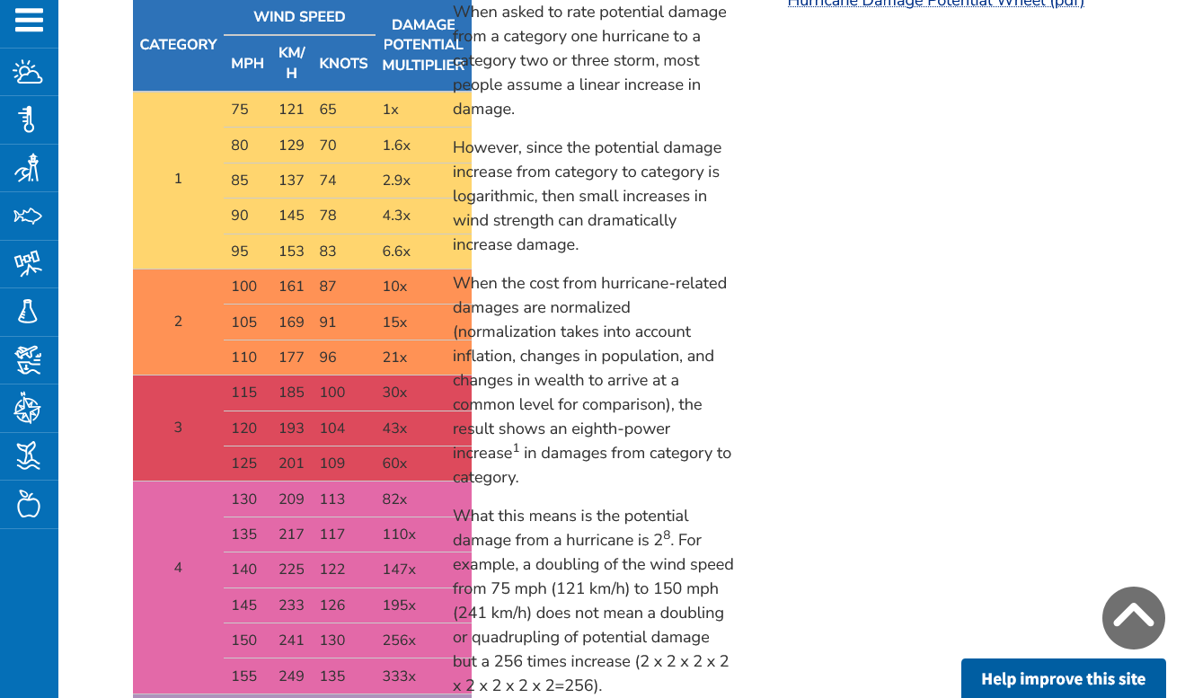
What about peak winds?
Scientists also have high confidence that wind speeds will increase in a warming climate and that the proportion of storms that intensify into powerful Category 4 or 5 storms will increase. Similar to rainfall rates, increases in intensity are based on the physics of extreme rainfall events.
Damage is exponentially related to wind speed, so more intense storms can have a bigger impact on lives and economies. The damage potential from a Category 4 storm with 150 mph winds, like Ian at landfall, is roughly 256 times that of a category 1 storm with 75 mph winds.
+++++++++++
metmike: This means that an increase in wind speed of 10 mph, increases damage on an EXPONENTIAL/LOGARITHMIC SCALE and isn't added to the damage, the same way that more moisture equates to more rain using a LINEAR SCALE!
For instance, The added 10 mph, from 100 mph winds to 110 mph winds will DOUBLE the damage potential!!
Here's how that works:
https://www.noaa.gov/jetstream/tc-potential
Much of the damage that occurred with Helene was from excessive rains, especially the catastrophic damage in NC! Climate change could have contributed an additional 7% (.07) to the extreme rains.
After an extreme event, I will often post this:
It really boils down to this, once again(Cliff Mass can be counted on as an elite source for using objective, authentic science)
https://cliffmass.blogspot.com/2016/03/the-golden-rule-of-climate-extremes.html
The GoldenRule
Considering the substantial confusion in the media about this critical issue, let me provide the GOLDENRULE OF CLIMATE EXTREMES. Here it is:
The more extreme a climate or weather record is, the greater the contribution of natural variability.
Or to put it a different way, the larger or more unusual an extreme, the higher proportion of the extreme is due to natural variability.
+++++++++++
However, hurricane winds are an exception to this rule because an increase of just 10mph from a slightly warmer water can equate to a doubling of the WIND damage in the areas close to landfall.
City Search & Rescue
A Nonprofit 501(c)(3) Disaster Relief Charity
Your Emergency Is Our Urgency
![]()
https://www.disasterassistance.gov/
![]()
U.S. Department of
Housing and Urban Development
Hurricane Assistance and Recovery
Learn how the U.S. government is responding to Hurricane Helene. Find resources to help you recover from the disaster.
https://www.usa.gov/hurricane-helene

Getting back to the extreme rains. They would NOT have been nearly so damaging if not for the coincidental occurrence of the very heavy rains from a frontal system BEFORE the hurricane. These were the 3 day rains thru early Thursday, September 26th BEFORE Helene made landfall. Helene was still in the GOM at this time!
How much of this was from climate change?
Answer: 7%
From natural variability: 93%
So the area's with 10 inches of rain got +.7 inches of additional rains = 10.7" that made the flooding slightly worse.
%20Oct%202%202024%20Winter%20Forecast%20Gulf%20of%20Mexico%20System%20Warm%20Dry%20October%20Brazil%20Monsoon%20-%20YouTube.png)
Not surprising how bad it got when considering how much of the area had 1,000++ year 3 day rain:
Estimated rainfall amounts from #Helene across the southern Appalachians had an Annual Recurrence Interval greater than 1000-years over a wide area; meaning there is less than a 0.1% chance (annual exceedance probability) of that happening in any given year.
https://twitter.com/nwsnwc/status/1841895926241059204?

Thanks much, Larry!
I get that this was very extreme and probably a 1 in 1,000 year event WHEN YOU ADD THE EXTREME RAINS THAT FELL BEFORE HELENE HIT, UNRELATED TO HELENE.
The NWS graph that you copied looks like the configuration of the total rain map that includes the system that dumped heavy rains BEFORE Helene hit. They state the dates of September 23-28 (when Helene was a hurricane) and call these rains Helene rains BUT THEY WEREN'T!!!! Half of them were from an unrelated weather system that hit BEFORE HELENE.
Here, let me show you:
Here's the total daily rainfall data from Asheville, NC in September. Near the epicenter of the heaviest rains.
Note the 3 days with heavy rain. September 25, 26 and 27, 2024.
https://www.weather.gov/wrh/Climate?wfo=gsp
Below is where Helene was when it became a hurricane on the 25th. NO WAY was it close to causing any rain in NC on the 25th!!! But the NWS and everybody else is counting the 4.09" of rain that day as Helene rains!
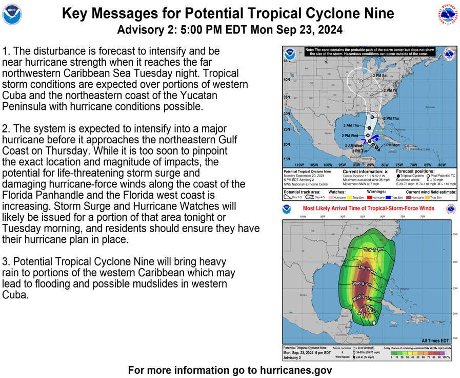
Re: Re: Potential NW Caribbean/GOM TC formation next wk
By metmike - Sept. 25, 2024, 1:37 p.m.
Hello Hurricane Helene! 80+ mph. Forecast to 125 mph late Thursday.

+++++++++++++++++++++++++++++++++++
Below is where Helene was on the evening of September 26, 2024. When some of the rains from Helene were just starting to bombard NC. So much of the rain, earlier in the day on the 26th was also NOT FROM HELENE!
Re: Re: Re: Re: Re: Potential NW Caribbean/GOM TC formation next wk
By metmike - Sept. 26, 2024, 5:29 p.m.
This was Hurricane Helene (frozen image) about to make landfall in the Big Bend area shortly after 11:30 pm EDT. Winds were 140 mph!
The image below that I captured just before midnight on September 26, 2024!
So Helene didn't start making a direct impact on rains in that area until the 3 day rain event was halfway over!
+++++++++++++++++++
When 2 systems strike one after the other like this, it's entirely from natural variability........with an extra 7% to totals from more water vapor in the air from a warmer atmosphere.
+++++++++++++++++++++++++
It really boils down to this, once again(CliffMass can be counted on as an elite source for using objective, authentic science)
https://cliffmass.blogspot.com/2016/03/the-golden-rule-of-climate-extremes.html
The GoldenRule
Considering the substantial confusion in the media about this critical issue, let me provide the GOLDENRULE OF CLIMATE EXTREMES. Here it is:
The more extreme a climate or weather record is, the greater the contribution of natural variability.
Or to put it a different way, the larger or more unusual an extreme, the higher proportion of the extreme is due to natural variability.
++++++++++
In every story that I've read, they attribute all the rains to Helene which is completely FALSE.
Also the extreme terrain/topography had everything to do with the extreme rains. Not sure if the NWS 3 day rain extreme return years, dials in that topography because the same 2 weather systems that caused the rainfall totals would have only produced LESS THAN HALF that rainfall absent the orthographic lifting from the topography/mountains.
That's why the heaviest rains occurred so far away from where the Hurricane hit the coast. The heaviest rains are almost always closest to the areas along the coast where the hurricane hits. We can see from your map and others how far away the heaviest rains were from the coast this time.
Mike said:
“In every story that I've read, they attribute all the rains to Helene which is completely FALSE.”
———————-
Hey Mike,
Excellent point. I already knew it wasn’t all from Helene. I already realized that the 3 days of heavy rains included ~2 days of a PRE (predecessor rain event while Helene was mainly still in the Gulf) followed by Helene’s direct heavy rains. So, yes, I see that the Tweet I quoted was not correct in associating all 3 days with Helene, herself.
But my point in posting this wasn’t to get into a debate about that valid point. Rather it was to show the reason for the extreme effects, a 3 day period of extreme rainfall, with a sizable portion of it classified per the tweet as a 1 in 10,000+ year event. I was assuming the topography was considered in this calculation but can’t actually verify that.
I assume you know about hurricanes Agnes (1972) and Camille (1969), both of which were also associated at least partially with extreme well inland rainfall/deadly and damaging rainfall. Camille’s was in VA while Agnes was in PA.
Thanks much, Larry!
I apologize if I came off as being confrontational and very much appreciated that map.
I figured you also knew this because you were following Helene too.......probably even closer than me.
But 99% of the people that see a graphic like that, did not know and will assume ALL the rain came from Helene and its the NWS that created that impression(not you).
Even if I totally disagreed with the map(I don't) its great to get other insights on a topic from somebody that has taught me quite a few things.
Your handle, "WxFollower" couldn't have been a better choice!
I agree too that having rain amounts that massive over 3 days, even if they were from 2 completely different weather systems was extraordinarily rare.
You’re welcome, Mike! You’ve taught us readers here a lot over the years. No worries are necessary about what you were concerned with. I generally enjoy our discussions.
I was reading the following about PRE:
https://site.extension.uga.edu/climate/2020/10/what-is-a-predecessor-rain-event-pre/
There’s no doubt that the PRE is separate from the direct storm effects. But this writeup suggests that the presence of a PRE is indirectly associated with a tropical cyclone. In other words had the TC not existed, the volume of rain falling from the PRE would NOT be nearly as heavy. Read this:
“Over time, scientists have noticed that some hurricanes and tropical systems generate areas of heavy rain far ahead of the main storm system. These events are called Predecessor Rain Events (PREs) because they generally occur about 36 hours ahead of the main storm passage and as much as 600 miles poleward of the storm center. The presence of a front in the area along with a strong moisture flow from the storm can enhance rainfall in this region, leading to potentially heavy rains that can cause flooding or set up the region for flooding once the main storm moves over the PRE region.”
So, there is an argument imo to count the PRE as part of the overall effect from Helene. Had there been no Helene, the rains from the PRE likely wouldn’t have been nearly as heavy (it wouldn’t have been a PRE). The flow around Helene, a big storm, not only enhanced the moisture flow into the 500 mb trough/upper low that was coming into the SE. It also caused the trough to slow/stall causing two days of rain. Had there been no Helene, there’d probably just be a more ordinary rain producing upper trough that didn’t have as heavy rain rates and that wouldn’t stall.
In sumnary, there were the indirect effects (PRE) as well as the direct effects.
Larry,
This is a great point.
We can often see how a weather system impacts other weather systems downstream.
Even a chain reaction sort of thing.
And teleconnections of different weather systems that often abide by similar spacing dynamics.
On Helene, I will comment specifically related to the downstream impact from Helene.
first, I want to access some upper level maps from those days to do an anAlysia which is more accurate than one just from my memory.
Since I was at my 50 year reunion last weekend, I missed several days of monitoring AFTER Helene hit and have been playing catch up.
If not for your new post, Larry, I would have missed this one completely.
After spending some time doing the research, I will have to push back on your graphic and the wide area of "Not surprising how bad it got when considering how much of the area had 1,000++ year 3 day rain"
Events that rare can happen close together, then not happen for another 2,000 years but an event very similar to this happened just 108 years ago. I'm very surprised that you didn't post about it.
The EXTREME flooding of 1916 was caused by 2 hurricane remnants that hit within a week. Amounts of rain were similar, even if this event had a bit more rain in some locations.
It would be like comparing a cat. 5 hurricane with 155 mph winds with an even stronger cat. 5 hurricane with 160 mph winds and claiming the previous one wasn't similar because the top winds were 5 mph less......and that a 160 mph hurricane only happens every 1,000+++ years but a 155 mph one happens every 100 years.
Those claiming that nothing close to this has ever happened before in this area are WRONG. The flood of 1916 was extremely close to this!
Any discussion on the historical significance of this flood that ignores the Great Flood of 1916 is not objective science. Let's be honest here too, the media's downplaying the 1916 flood is related to using this RECORD flood to sensationalize the unprecedented climate crisis from burning fossil fuels.
Here's a perfect example:
Climate change is making hurricanes stronger and wetter.
"Another estimated that climate change caused some parts of Georgia and the Carolinas to get 50% more rainand that the rainfall totals were made up to 20 times more likely because of climate change."
This is complete junk science to state that climate change caused 50% more rain from this event. The rain totals in 1916 were BEFORE climate change. How did that happen???
Later on they claimed this, though:
"In 1916, 25 people died when floodwaters swept away buildings, destroyed the local power plant, ruined the railroad and cut Asheville off from the rest of the country, according to the Asheville Museum of History.
The similarities are striking."
Actually, at least 80 people died in that flood, not 25!
+++++++++++++
OK, on the next page(s) I'll post information on the Great Flood of 1916 in this exact area, like it deserves.
NC Extremes: Flood of 1916 Wiped Out Railways, Records
https://climate.ncsu.edu/blog/2015/07/nc-extremes-flood-of-1916-wiped-out-railways-records/
The storm’s northwesterly track, along with the orientation of winds, lined up almost exactly perpendicular to the peaks in the northern mountains, putting this area in a prime location for upsloping. As a result, a weather station in Altapass measured 22.22 inches of rain from 2:00pm July 15 to 2:00pm July 16, shattering the U.S. record for the most rainfall within 24 hours at that time. While this U.S. record has since been broken and currently stands with a station in Texas, Altapass still holds the statewide record for most rainfall observed in a 24-hour period.
This map below are the rain totals FOR JUST A 24 HOUR PERIOD-108 years ago!!!!
The highest 1 day amounts were greater than any rains from Helene during a 24 hour period but they both occurred in the exact same area BECAUSE OF THE TOPOGRAPHY and ORTHOGRAPHIC LIFT that greatly enhanced rain amounts...NOT THE CLIMATE CRISIS. The slightly warmer atmosphere can hold ~7% more moisture, which does increase rain amounts but not by the absurd +50% claimed by NBC News on the previous page.
Additionally, runoff from extreme rains can’t spread out like it does on flat land. It all runs down the mountains and steep hills and get funneled into a very narrow area at the bottom.

++++++++++++++++
https://storymaps.arcgis.com/stories/bcb2e5373c21491c9e68e96a8156d92b
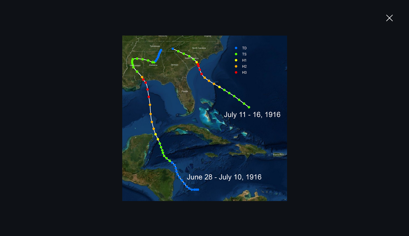
This was the path of the remnants of the 2 hurricanes that caused the historic flooding in July 1916 to this same area. Hurricanes didn't have names back then(they got numbers)!
++++++++++++
https://en.wikipedia.org/wiki/1916_Atlantic_hurricane_season
Very active with 10 hurricanes and 5 MAJOR hurricanes but peak winds did not exceed 130 mph, likely from ocean temps being cooler 108 years ago!


Scroll down for more:
Total 3 day rains from this last event:
https://climate.ncsu.edu/blog/2024/09/rapid-reaction-historic-flooding-follows-helene-in-western-nc/

++++++++++++++++
Total 1 day rains in 1916(there was more rain than just this)
The storm’s northwesterly track, along with the orientation of winds, lined up almost exactly perpendicular to the peaks in the northern mountains, putting this area in a prime location for upsloping. As a result, a weather station in Altapass measured 22.22 inches of rain from 2:00pm July 15 to 2:00pm July 16, shattering the U.S. record for the most rainfall within 24 hours at that time
https://climate.ncsu.edu/blog/2015/07/nc-extremes-flood-of-1916-wiped-out-railways-records/

I thought this map amusing because the hurricanes had NUMBERS back then.

So the question is.
If 2 similar EXTREME weather events occur in 108 years in the same place for similar(topographical) reasons , one before climate change, one after climate change, is it accurate science to call the 2nd one a 1 in 1,000+++ year event?
That would mean an assumption that this won't happen again for at least another 1,000 years.
As a meteorologist for more than 4 decades, I would call this a 1 in 100 year event FOR THAT LOCATION based on the meteorology, topography and historic record.
Do we have weather records going back 1,000 years for this area?
Accurate weather records only started in the state of North Carolina in 1870, 154 years ago. In that time, we've had 2 of these 1,000+++ year events.
If I could bet on it and live for another 100 years, my money would be on another one similar to this in that time frame. That location is just soooo favorable and there are just too many weather systems that can cause exactly the same thing that just happened. In fact, one that stalled or lingered longer, instead of moving quickly like these 2, would be MUCH WORSE!!!
This is an interesting view:
You already know this Larry.
A 1 in 100 or 500 or 1,000 year flood has INDEPENDENT ODDs in each year.
The odds next year for an event like this are the same as they were before this year. In fact, I would strongly content that the odds SHOULD GO UP BY ALOT NOT DOWN for another event, every time you have one........if they are properly calculating odds using an unbiased model, considering the data time period with accurate observations is extremely short..........so each extreme event should have a big impact and adjustment to making that event more likely, especially the most extreme ones.
Observations should get a tremendous amount of weighting. If a certain place, like NC has had 2, 1,000+ year rains in 108 years and 5, 100 year rains in 100 years, the models need to be updated to dial in a much higher frequency of extreme rains that what is being predicted.
Having 1 in 100 year events occur 5 times in 100 years suggests its a 1 every 20 years event!
This article touches on many wonderful points. It's the best I've seen on the topic.

Since the U.S. is a big country, we should expect to see a bunch of 0.1% probability rainstorms every year. The chance of such a storm occurring at any specific location is extremely low, but the chance of one occurring somewhere becomes quite a bit higher.
Put another way, even if you are unlikely to experience a 1,000-year storm at your location, there likely will be 1,000-year storms somewhere in the country every year.
Why have so many storms that, historically and statistically, should be exceedingly rare, struck the Carolinas in just a few years? There are two main reasons, which are related.
First, estimating the probability of rare events requires increasingly large amounts of data. NOAA’s Atlas 14 was last updated for the Carolinas in 2006, and those calculations only used data through 2000.
As more storms occur and more data is collected, the estimates get more robust. Given that reliable rainfall measurements only extend back about 100 years, the true probability of this much rain in the Carolinas may have been underestimated up until now.
++++++++++++++
According to them the models they use to predict the frequency of these events has not been updated with any data from after the year 2000! That's crazy!!!. Are they doing this intentionally to have more extreme rated events??? That's over 2 decades without updating in a world with slowly increasing extreme rains.
More good information:
https://www.usgs.gov/faqs/how-can-1000-year-rainfall-not-result-1000-year-flood
Just earlier in the month of September in North Carolina......they had another 1 in 1,000 year rainfall event!
Historic rainfall occurred across the Cape Fear Region of southeastern North Carolina on September 16, 2024. Gauges and automated radar estimates showed that 12 to 20 inches of rain fell in only two days, creating severe flash flooding affecting Carolina Beach, Southport, Bolivia, and Boiling Spring Lakes. Although this system never became a named tropical system, observed weather impacts including strong winds, heavy rain, and flash flooding were similar to tropical storms and hurricanes of the past.
Potential Tropical Cyclone Eight was an area of low pressure that developed off the Carolina Coast on September 13, 2024. While it initially developed along a stalled front, over several days the system began to draw energy from the warm ocean surface. As winds increased, the low was given a "Potential Tropical Cyclone" categorization late in the afternoon of September 15, indicating that conditions could support its evolution into a tropical or subtropical storm. A Tropical Storm Warning was issued for the Carolina coastline for the expectation of these weather conditions.
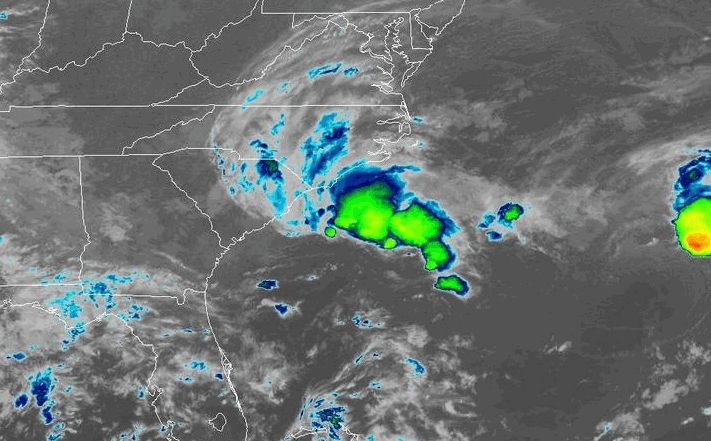 Infrared satellite loop from September 15-16, 2024 showing Potential Tropical Cyclone Eight moving inland |
While the system displayed some tropical characteristics at times, Hurricane Hunter aircraft sent to investigate the storm found it never developed a symmetric wind circulation and it maintained horizontal temperature contrasts not consistent with the structure of tropical storms.
Regardless of the nature of the storm, Potential Tropical Cyclone Eight brought historic rainfall and flash flooding to parts of Brunswick and southern New Hanover counties. Storm total rainfall totals of 12 to 20 inches were recorded within a 25-mile wide stripe running from Carolina Beach and Southport through Bolivia, the Green Swamp, and ending south of the Delco community in eastern Columbus County. The majority of this rain fell within a 12 hour window between 5:00 am and 5:00 pm on Monday, September 16. Flash flooding quickly developed in Carolina Beach during the morning hours, then shifted northwestward following the heaviest rainfall rates as the center of Potential Tropical Cyclone Eight shifted onshore.
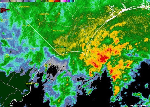 Radar loop from September 16, 2024 showing Potential Tropical Cyclone Eight moving onshore. Extremely heavy rain developed in a large convergence band on the northern edge of the low, dropping exceptionally heavy rainfall which led to historic flash flooding. |
Gauge-measured rainfall in excess of 12 inches within a 12 hour period is expected to occur, on average, once every 200 years across coastal southeastern North Carolina. A few spots may have had rainfall amounts as large as 18 inches within a 12 hour period, approaching the kind of event expected to occur, on average, once every 1000 years. These estimates are calculated in NOAA Atlas 14, a reference document that shows the climatological recurrence of heavy rainfall events.
++++++++++++++++
We are supposed to believe that the above occurrence would only be expected to happen 1 time every 200 years and even 1 time every 1,000 years?? NO WAY!!!!
When they make statements like that, it completely destroys the credibility of the source and devalues the meaning of that term.
+++++++++++++
Here's the thing. We know the ocean water temperature is HIGHER than it's every been the last 150 years. Without a question, this means MORE extreme rain events.
Why are they still using OLD DATA from BEFORE 2001 to calculate these climatological recurrence of heavy rainfall events in 2024????
I still think that it was not accurate BEFORE 2001 based on the numerous extremely heavy rain events in the past but now it's so bad that its an embarrassment that greatly damages the sources credibility as seen by objective scientists that understand the AUTHENTIC metrics and meteorology.
They have insisted everywhere, every year for 2 decades that climate change is increasing the chances for extreme rain events but then, they use data from THE OLD CLIMATE TO CALCULATE THE RETURN ODDS OF TODAY'S CLIMATE!
+++++++++++
OK, I did some checking. The NOAA Atlas 15 document is supposed to dial in these changes........finally but not for a couple of years will they be available for use by the public. The ones being used still now and for North Carolina from recent events are still the outdated NOAA Atlas 14 documents based on data more than 2 decades old.
++++++++++++++++++++++
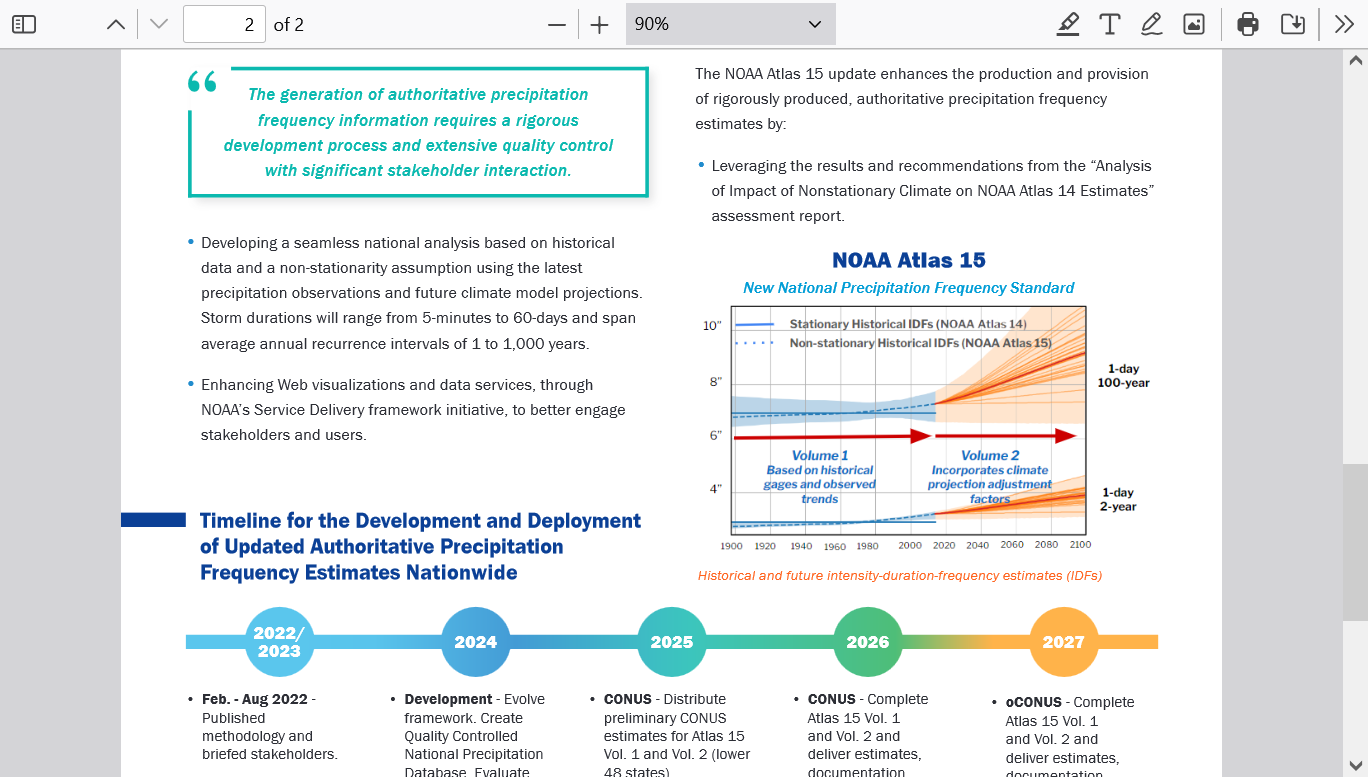
NOAA ATLAS 15:
Update to the National
Precipitation Frequency
Standard
Atlas 14 volume
First National Precipitation Frequency Analysis Accounting for Climate Change
Historically, NOAA precipitation frequency estimates have been funded by states and other users, on a cost-reimbursable basis, for individual
subsets of the U.S. However, with the 2022 Bipartisan Infrastructure Law (BIL), OWP received first-ever direct Federal funding to (1) update
the NOAA Atlas 14 precipitation frequency standard while accounting for climate change, and (2) develop precipitation frequency estimates
for the entire U.S. and its territories.
These updated precipitation frequency estimates will be referred to as NOAA Atlas 15 and will be presented in two volumes. Volume 1
will account for temporal trends in historical observations, and Volume 2 will use future climate model projections to generate adjustment
https://www.weather.gov/media/owp/hdsc_documents/NOAA_Atlas_15_Flyer.pdf
IT'S WAY PAST DUE!
As of Thursday, Oct. 3, more than 200 people have died due to Hurricane Helene.
In North Carolina, 115 people have died. In addition, South Carolina has reported 41 fatalities, Georgia 33, Florida 19, Tennessee 11 and Virginia two for a total of 214.
Hundreds are still missing in Western North Carolina.
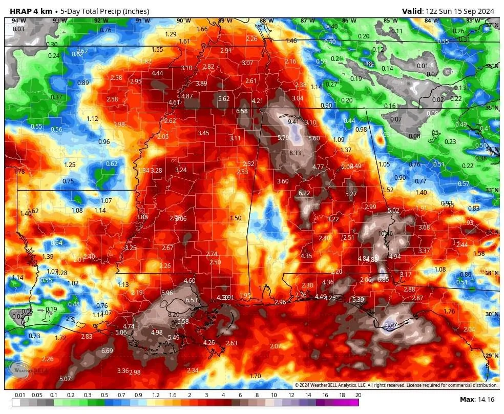
While Helene dumped rain on the western portion of the Carolinas, the area had already been drenched the week before by storms. Here's how many inches of rain communities saw between Tuesday, Sept. 24 and Saturday, Sept. 28, according to the National Weather Service.
++++++++++++++++++
These were 4 day rainfall totals.
++++++++++++++
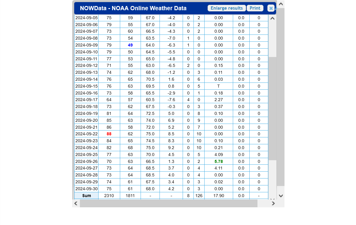
In Asheville, the French Broad hit 24.67 feet, 1.5 feet above its previous highest crest. Further downstream at Blantyre, the river surpassed its 1916 crest of 27.1 feet to hit 27.38 feet before the gauge stopped reporting on Friday afternoon.
The Swannanoa River at Biltmore crested at 26.1 feet, more than five feet above what it did at its maximum in 1916 and slightly above the apparent 26-foot crest in April 1791, noted the climate office.
+++++++++++++
Whoa! 80 years before the NWS started keeping accurate records, there was ANOTHER EARLIER event, having an impact extremely similar to this one.
So now we have 3 extreme flooding events very similar to what Helene caused in 233 years:
1791
1916
2024
I rest my case on this NOT being a 1 time in 1,000+++ event. The observations/data and science clearly show the term 1 in 100 year event to be the more accurate and appropriate one!
https://water.noaa.gov/gauges/BLTN7

By metmike - Oct. 7, 2024, 12:11 p.m.
Just updated:
To repeat: NOAAs official definition of a La Nina is a LAGGING INDICATOR(3 month average). As a result, the ocean and atmosphere will be in a La Nina mode for a couple of months BEFORE NOAA announces: "Hey everybody, the cooling tropical Pacific water has suddenly crossed the threshold to meet our La Nina standard/definition"
The current cool water temp anomalies are right on the threshold for NOAA. The ocean/atmosphere crossed that threshold months ago when it started cooling.
This is what has caused the late growing season drought in the Midwest!!!!!!! Not the fake climate crisis!
https://www.drought.gov/data-maps-tools/nasa-sport-lis-soil-moisture-products
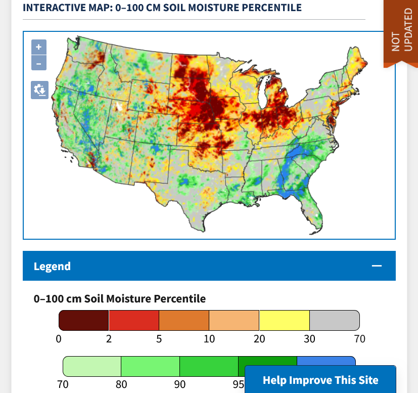
La Nina's are NATURAL oceanic phenomena that have been taking place for at least thousands of years. They happen periodically and when cooler water in the deep ocean is brought to the surface.
El Ninos are the complete opposite(warm water anomolies) and also NATURAL. The key area in the tropical Pacific that we use to determine this is known for its ability to have the biggest role on global weather patterns.
+++++++++
The only reason that the drought in the Southeastern 1/3rd of the US has been wiped out is because of the remnants of hurricanes coming up from the Gulf of Mexico. Fact is, the current La Nina in the atmosphere is VERY FAVORABLE for hurricanes just like these because it suppresses wind shear. Climate change ADDED around 7% moisture but the hurricanes were CAUSED BY NATURAL VARIABILITY, INCLUDING THE CURRENT LA NINA!
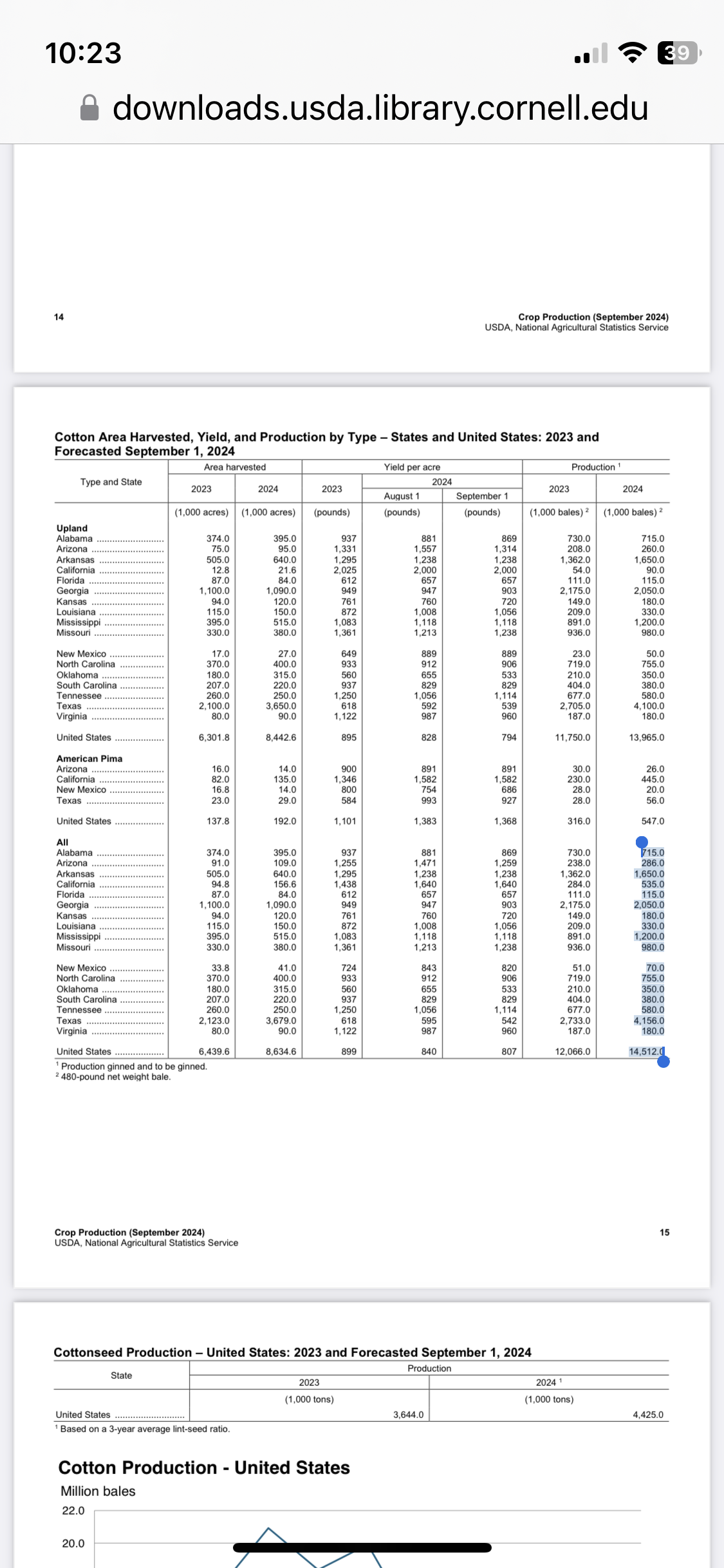
If I were still actively trading I would have looked to go long CT in advance of Helene due to then being open boll season in the SE US. At that time, ~3/4 of bolls were open in GA (and ~90% in SC) making them highly vulnerable to damage from wind blowing them to the ground (quantity reductions) and rain causing quality reductions. Very little had yet been harvested.
Preliminary estimates of losses to the U.S. CT crop are very roughly 400K to 800K bales with almost all of that in GA, one of the top producers and the top in the SE. These losses are roughly estimated to be 20% to 40% of the GA crop, which would be roughly 2.7% to 5.5% of the US crop. We’ll know more when the Oct monthly crop production report is released.
Weekly USDA crop conditions did go down significantly in GA though not in SC. In GA as of the week ending 9/22, VP to P were at 11% while G to E were at 59%. The subsequent week in GA ending 9/29 was at 25% VP to P and 33% G to E. And then the week just released yesterday (ending 10/6) was at 31% VP to P and 34% G to E. So, during that 2 week interval, VP to P rose in GA from 11% to 31% while G to E dropped from 59% to 34%.
The overall US crop for the same 2 week interval went from 33% VP to P and 37% G to E to 35% VP to P and 29% G to E. So, VP to P rose from 33% to 35% while G to E dropped from 37% to 29%.
https://usda.library.cornell.edu/concern/publications/8336h188j?locale=en
However, when looking at daily price history (see image below), I don’t see any significant rise that I can attribute to these losses (look at far right column of daily % change). Helene moved rapidly through the SE big CT areas mainly the night of 9/26-7.
Here are links to news about it:
https://www.insurancejournal.com/news/southeast/2024/10/02/795348.htm

The image below is from last month’s USDA Prod. Report. Highlighted are the estimates as of 9/1/24. Note that GA was 2nd highest in US:
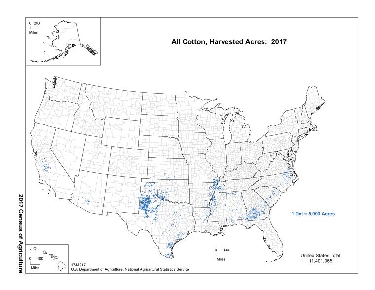
This image shows that in GA the heaviest concentration of CT is in SW GA and to a lesser extent in SC GA:

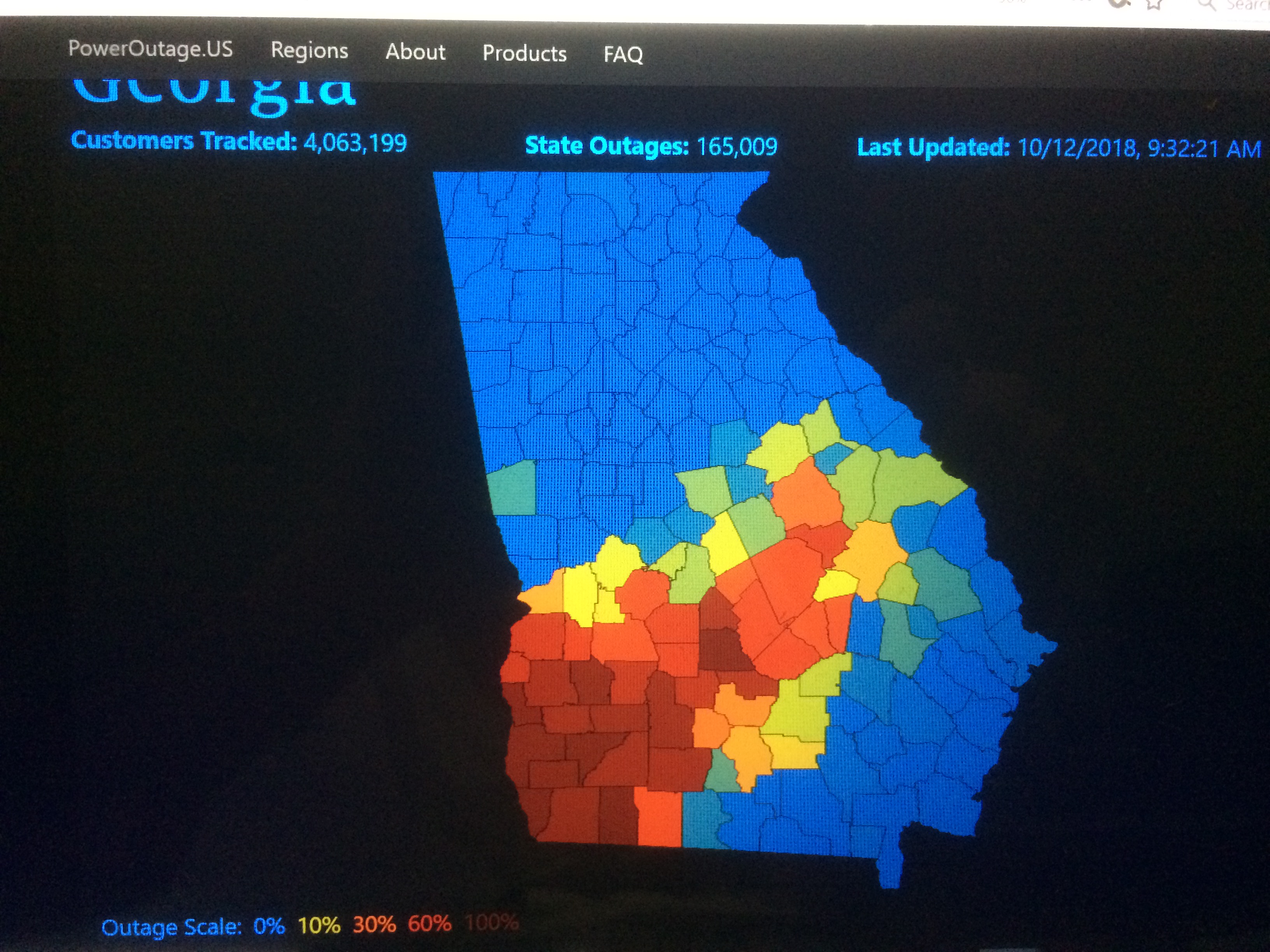
The heavy rainfall in the S 1/2 of GA covered all of the most dense CT counties in SW and SC GA, meaning significant quality losses likely. However, the highest winds in the S 1/2 of GA missed SW GA and were instead over SC GA as suggested by the outage map below. That means that quantity losses, while large, were not as high as would have been the case if Helene’s center had tracked just 50 miles further west:

Totally agree with your assessment of looking to buy CT.
I anticipate a daily cycle low Wednesday, on October expiration (note--no vol or OI in Oct ct). It may be (or has been) today.
This daily low comes in week nine of the weekly cycle, thus at/near the half cycle low time frame.
I have an order in to buy the Nov 72 call (perhaps priced too conservatively)
Will buy call(s) tomorrow at some price.
GOOD EYE FOR A TRADE AND GREAT POST!!
Thanks, tjc!
How does Helene estimated CT GA damage from wind and rain compare to actual from 2018’s Michael? Per the USDA Crop Prod reports before vs after, GA lost ~1 million bales or 34% of the pre-Michael estimate of a whopping 2.9 million bales. That was easily the largest GA loss in # of bales on record from what I recall. Per USDA, VP to P in GA rose from 9% to 46% (35 point rise) while G to E fell 38 points. These #s are quite a bit larger than the 20-25 point swings from Helene. The US G to E fell 7 pts.
Why was the Michael loss so large? The image below shows the 2017 CT prod. map showing the densest in SW GA. Note that ~80% of bolls were open then in GA (slightly more than that during Helene):
Now check out the power outage map (2nd image) showing highest in SW GA (the heart of CT) (much higher vs Helene) though they were far lower in SC GA, the 2nd most dense GA CT area (much lower than that for Helene):
tjc,
Cotton is down sharply today for you to buy. I'm not interested.
December is -$1.6 c
October cotton is -$5.6c This is greater than the limit down for back months but not the front month.
Cotton often trades in sympathy with crude oil and crude is -$3.6 dollars today but something bearish is going on with the soon to expire October cotton today.
https://www.cropscience.bayer.us/articles/dad/managing-cotton-through-hurricane
++++++++++++
Much more to come later today!
The Oct USDA Crop Production report will be released on Fri, Oct 11.
Based on my analysis in the posts above, I’m guessing that the GA CT crop will end up with a 500-600K bale drop due to Helene. That would mean a 24-29% drop from the 2.05 million bales in the Sep report. This would compare to a ~34% drop from Michael. So, it would be big but not quite as big as the % from Michael in GA. I’m thinking not quite as big because the crop ratings changes were 20-25 pts for Helene vs 35-38 for Michael. Also, the highest winds for Michael were in the somewhat denser SW GA vs not quite as dense SC GA for Helene. An additional minor factor is that open bale % apparently was slightly higher for Michael (~80+) vs ~75 for Helene.
For the total US crop, how would these GA losses compare? A 500-600K GA loss would by itself be a 3.4-4.1% loss from the Sep est of 14.5 million bales. (Of course, other states will also have a say and I’m not projecting those.) The 1 million bale Michael loss was out of a 19.7 million bale US crop per the pre-Michael report or 5.0%. So, I’m projecting a slightly lower % loss in GA vs the total US crop for Helene vs Michael though still significant.
Whatever the loss turns out to be, will it all be reflected in the Oct report considering that Helene didn’t go through GA til 9/26-7? Or will that have to wait til the Nov release?
To be clear, I’m not making any trade recommendations. I’m just estimating the crop damage %. Normally it would already be reflected to a good extent in daily prices including prices just before the storm. There could be other larger factors that have been dominating CT pricing.
Here are estimated highest wind gusts from Michael (highest in SW GA):

Thanks, Larry.
i got the usda crop conditions/ratings for the last 3 weeks for those 3 states and the US and will share that when back in the office.
The biggest drop in ratings for the US crop actually happened after Francine.
Hey Mike,
YW. In case you missed it, I already posted this about GA, the only state affected heavily by Helene, itself:
“Weekly USDA crop conditions did go down significantly in GA though not in SC. In GA as of the week ending 9/22, VP to P were at 11% while G to E were at 59%. The subsequent week in GA ending 9/29 was at 25% VP to P and 33% G to E. And then the week just released yesterday (ending 10/6) was at 31% VP to P and 34% G to E. So, during that 2 week interval, VP to P rose in GA from 11% to 31% while G to E dropped from 59% to 34%.”
Great work, Larry!
Your GA stats are right on the money (along with other stuff) and cover the main damage from Helene, so I'll Just post the stats for the entire crop going back to Sept. 9, 2024.
Francine hit on Sept. 11th. One would think that mostly LA, MS, AL (sw GA?) and TN had issues that came differently than with Helene(less wind). Mod/heavy rains over several days in TN cotton country for instance.
Date G/E F P/VP
Sept. 9 40 32 28
Sept. 16 39(-1) 35+3 26(-2)
Sept. 22 37(-2) 30-5 33(+7) Francine deterioration? TX had big drops(+9 p/vp)
Sept. 29 34(-3) 32+2 37(+4) Helene deterioration?
Oct. 6 29(-2) 36-4 35(-2) More from Helene?
Change -11 +4 +7
We should note that the big drop in crop ratings after Francine, also came from other states not impacted by Francine dropped, especially TX, which saw a whopping +9 in the p/vp category. So I would actually say that the TX drought was the biggest contributor., not Francine.
However, we should note that traders were already trading plunging crops ratings from a deteriorating national crop for over 2 weeks BEFORE Helene hit.
The biggest trading opportunities come when we go from one type of weather to the exact opposite for the crop. This usually maximizes the most covering of current positions and adding to the opposite positions based on the weather SUDDENLY going from bearish to bullish or bullish to bearish.
Going from bullish to MORE bullish follows THE LAW OF DIMINISHING RETURNS!!! Not always(if stocks are precariously low, for instance) but most of the time, it will take more and more powerful news to cause the same price reaction.
I think that crop ratings already plunging BEFORE Helene hit and traders already reacting with higher prices made it TOUGHER for the price to react compared to if the crop ratings had not already plunged and cotton price reacted BEFORE Helene.
5 day rains from Francine Sept 11-16?
THE CHARTS FOR COTTON BELOW ARE FOR THE FRONT MONTH. DECEMBER COTTON HAS A COMPLETELY DIFFERENT, MUCH MORE BULLISH LOOK THAT MINIMIZES THIS WEEKS SPIKE LOWER. ITS STILL IN AN UPTREND SINCE THE BOTTOM, JIST BEFORE FRANCINE RISK PREMIUM STARTED JSPIKING THE PRICE HIGHER IN SURGES.
https://tradingeconomics.com/commodity/cotton
1. 1 month-Front month October crashed today. Expiration soon was a factor. Not sure what cash prices are but harvest pressure could be a factor. Oil prices plunging too. Like I said earlier, this is a dangerous, uncertain time to trade. Prices had already jumped a great deal in the first half of Sept from the crop deterioration.
2. 1 year-October testing July lows and would appear to be having a downside break out..........but this is entirely a front month signature. December cotton is still well above the Summer lows. We've dropped a great deal since the Feb. 28 highs over $1!
3. 10 years- April 2022 spike highs at $1.56
4. 60 years-All time high in March 2011 at $2. Severe drought from La Nina in TX at that time.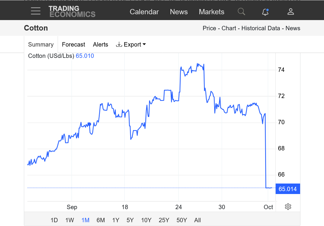

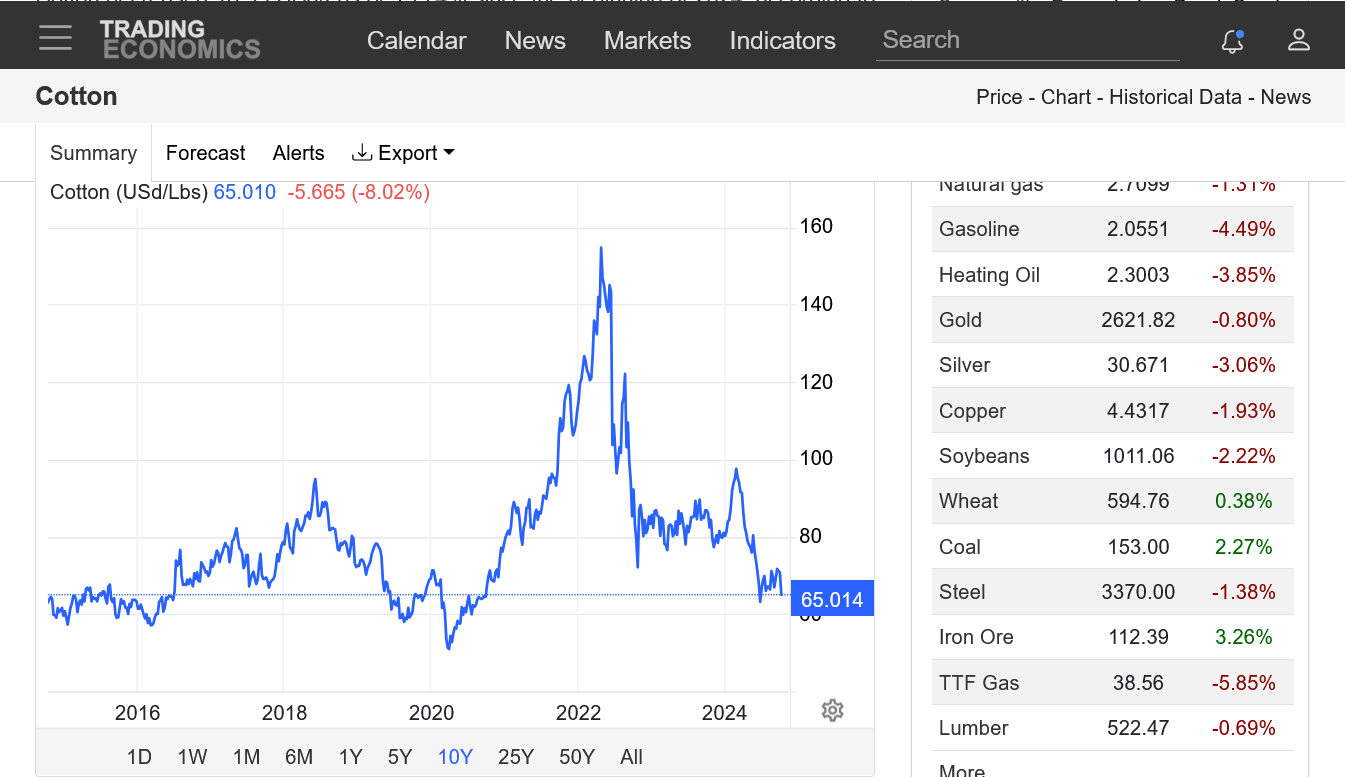

This is an interesting seasonal for cotton. I can see the big drop when planting and growing conditions are favorable, which is most of the time. I think the steady prices in the Summer are probably misleading and come from an average of some extremes........down with good weather...........up with bad weather.
The jump in the Fall starts BEFORE harvest. Strong seasonals from Oct-end of Feb(outside of Nov). Not sure why,
https://charts.equityclock.com/cotton-futures-ct-seasonal-chart

Mike said:
“Francine hit on Sept. 11th. One would think that mostly LA, MS, AL (sw GA?) and TN had issues that came differently than with Helene(less wind). Mod/heavy rains over several days in TN cotton country for instance.”
——————-
Hey Mike,
I think I found the only state heavily affected: Arkansas!
-Ark 3rd only to TX and GA with pre-Francine crop (1.65 million bales)
- Ark had highest % of open bolls of any state pre-Francine with a very high ~90%
-Your Francine rainfall map has 4-5” over NE Ark, the heaviest in Ark. The two top producing Ark counties are Mississippi and Craighead, which are in far NE Ark. Lee county, in EC Ark, had ~3”. It was mentioned in an article I saw as one of the worst hit counties by Francine for CT. It is the 4th highest producer. Poinsett county was mentioned in the same article as having been hard hit. It had the heaviest rain of any Ark county per your map with 4-6”! Those 4 counties together produced ~650K bales in 2023, which was ~50% of the Ark crop!
-The only state in the Delta or SE that had a notable decline in ratings between 9/8 and 9/15 was Ark. There the VP to P increased 9 pts while G to E decreased 10 pts.
-CT had strong rises on 9/10, 9/11, and 9/15. These, especially 9/10 and 9/11, apparently were largely related to Francine. Thanks for pointing this out. As you said, those rises must have taken the stuffing out of further rise potential with Helene.
News about Ark CT:
CT price rises related to Francine
Wow, Larry!
Great catch on seeing AR,as one of the states impacted by Francine.