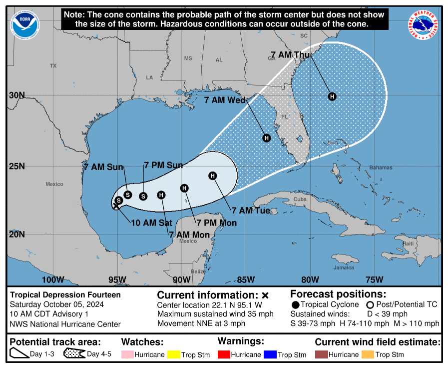
Possible W coast FL threat mid week!
Tropical Weather Outlook
NWS National Hurricane Center Miami FL
800 PM EDT Fri Oct 4 2024

For the North Atlantic...Caribbean Sea and the Gulf of Mexico:

1. Gulf of Mexico:
A broad area of low pressure located over the southwestern Gulf of
Mexico is producing disorganized showers and thunderstorms.
Gradual development of this system is expected, and a tropical or
subtropical depression or storm is likely to form late this weekend
or early next week while the system moves eastward or northeastward
across the Gulf of Mexico.  Interests in the Florida Peninsula and
the Florida Keys should monitor the progress of this system.
Regardless of tropical or subtropical development, locally heavy
rains could occur over portions of Mexico during the next day or
two, and over much of Florida late this weekend through the middle
of next week.
* Formation chance through 48 hours...low...30 percent.
Thanks, Larry!
weve already had 2 major hurricanes hit the gulf coast this year…Beryl and Helene.
i wonder what the record is for major hurricanes hitting the gulf coast in 1 year.
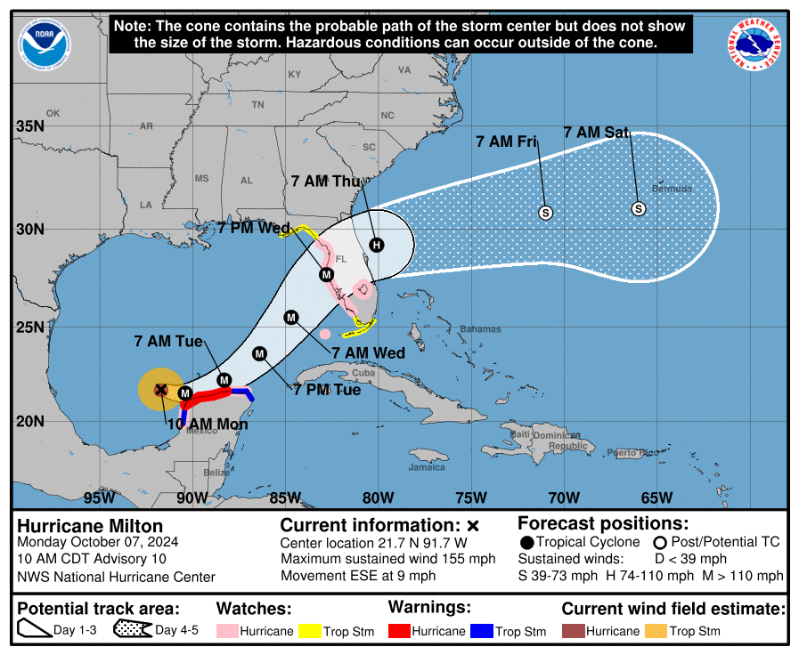
Hello Milton!
Hurricane in 48 hours.
Peaking at ~110+ mph in 72-96 hours.(Tue-Wed).
https://www.nhc.noaa.gov/text/refresh/MIATCDAT4+shtml/051459.shtml?
https://www.nhc.noaa.gov/refresh/graphics_at4+shtml/150217.shtml?cone#contents
Extremely wide range in the model forecast intensities right now.
Milton is small compared to the huge Helene, which makes rapid changes in intensity easier to accomplish physically by the hurricane.
++++++++++++++++++++
Very warm water also favorable for rapid intensification, along with La Nina suppressed wind shear(which is why early season forecasts were so hurricane bullish)
https://www.ospo.noaa.gov/data/sst/contour/usatlant.fc.gif

As mentioned previously, Milton's small size, along with warm water(some from climate change) and the suppression of wind shear by the Natural La Nina have led to RAPID INTENSIFICATION!
Top winds in Milton increased almost 100 mph in just 24 hours.........the 3rd greatest increase in history! Only Wilma-2005 and Felix-2007 strengthened faster than this)
Milton will hit Florida, with potentially cat. 5 catastrophic winds!
https://www.nhc.noaa.gov/text/refresh/MIATCDAT4+shtml/051459.shtml?
https://www.nhc.noaa.gov/refresh/graphics_at4+shtml/150217.shtml?cone#contents
La Nina IS a major factor making it favorable for increased tropical activity in the Atlantic Basin because it suppresses wind shear that kills hurricanes. This is the biggest reason (along with warm water anomalies) for forecast tropical activity to be a record earlier this year.
El Niños have the opposite impact, INCREASING upper level winds and shear in the Atlantic basin that includes the gulf of mexico.
hurricanes love a symmetrical wind pattern with height. If the winds aloft are much faster they tear the hurricane apart and cause the hurricanes vertical motions to be tilted with height, instead of maximizing the .transport of heat and moisture from a more symmetrical storm.
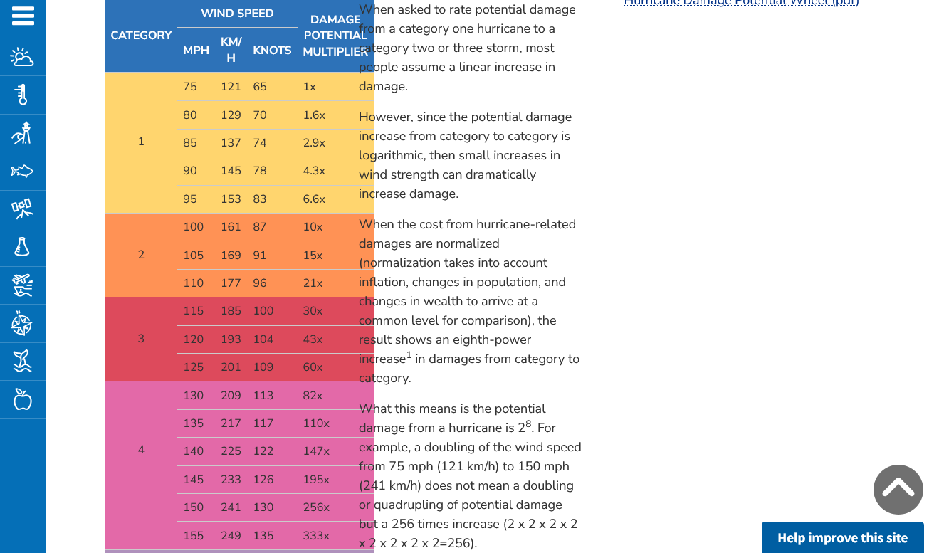
I copied this post from a week ago to stress the importance of the exponential increase in wind damage from increasing wind speed.
Milton, although small in size will have some EXTREME winds around the eye wall when it hits Florida. The increase in damage from a 120 mph to a 130 mph wind is double. 120 mph to 140 mph is quadruple. 120 mph to 150 mph winds causes an 8 times greater wind damage potential.
Re: Re: : Potential NW Caribbean/GOM TC formation next wk
By metmike - Sept. 30, 2024, 3:27 p.m.
Back from Detroit!
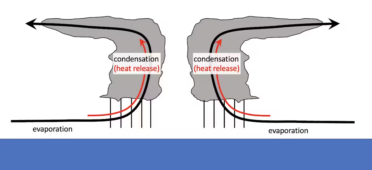
The temperature of both the ocean and atmosphere are critical to hurricane development.
Hurricanes are powered by the release of heat when water that evaporates from the ocean’s surface condenses into the storm’s rain.
A warmer ocean produces more evaporation, which means more water is available to the atmosphere. A warmer atmosphere can hold more water, which allows more rain. More rain means more heat is released, and more heat released means stronger winds.
+++++++++++++
metmike: An increase in temperature of 1 Deg. C (almost 2 Deg. F) allows the atmosphere to hold 7% more moisture. Which would equate to a potential for 7% heaver rains. 10.0 inches of rain can become 10.7 inches of rain, all other things being equal.
What about peak winds?
Scientists also have high confidence that wind speeds will increase in a warming climate and that the proportion of storms that intensify into powerful Category 4 or 5 storms will increase. Similar to rainfall rates, increases in intensity are based on the physics of extreme rainfall events.
Damage is exponentially related to wind speed, so more intense storms can have a bigger impact on lives and economies. The damage potential from a Category 4 storm with 150 mph winds, like Ian at landfall, is roughly 256 times that of a category 1 storm with 75 mph winds.
+++++++++++
metmike: This means that an increase in wind speed of 10 mph, increases damage on an EXPONENTIAL/LOGARITHMIC SCALE and isn't added to the damage, the same way that more moisture equates to more rain using a LINEAR SCALE!
For instance, The added 10 mph, from 100 mph winds to 110 mph winds will DOUBLE the damage potential!!
Here's how that works:
https://www.noaa.gov/jetstream/tc-potential
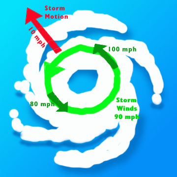
Another reminder of why we refer to the right side of hurricanes as the "dirty side"
This is where the circulation piles up the water to maximize the storm surge.
This is where the speed of the hurricane ADDs to the surface winds.

Here's another graphic depicting that principle:
The hurricane center link is swamped and not working at the moment. Max winds are up to 180 mph and one of the strongest ever but forecast to weaken to 130 mph at landfall.
Back up:
https://www.nhc.noaa.gov/text/refresh/MIATCDAT4+shtml/051459.shtml?
https://www.nhc.noaa.gov/refresh/graphics_at4+shtml/150217.shtml?cone#contents
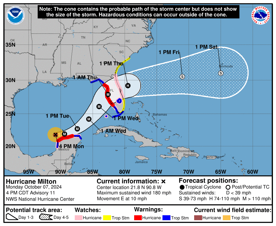
Down to 165 mph. Maybe peaked. Though winds drop to cat 3 just before landfall the eye wall with the highest winds expands.
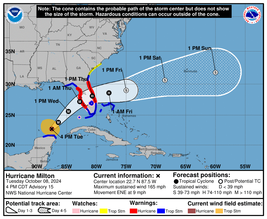
milton remains a cat 1 hurricane, when exiting on the east coast of Florida.
We can start tracking the northern fringe of the hurricane. This will get very impressive the next 24+ hours. This should update every 6 minutes. If not, you can hit the link for the latest.
https://www.spc.noaa.gov/exper/mesoanalysis/new/viewsector.php?sector=18

https://www.nhc.noaa.gov/text/refresh/MIATCDAT4+shtml/051459.shtml?
https://www.nhc.noaa.gov/refresh/graphics_at4+shtml/150217.shtml?cone#contents
Milton's winds will decrease a bit before landfall but the size of the storm is expanding so the areas with tropical storm and hurricane force wind will be greater than they are now. To this point, Milton has been fairly small, which is a huge part of why it was able to strengthen so fast yesterday.


This is likely NOT going to be the hurricane of the century as some are calling it. This FOR SURE WILL NOT have anything close to the flooding or deaths from Helene which were mostly the result of the TOPOGRAPHY of western NC which massively enhanced rainfall amounts.
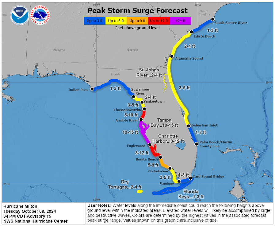
However, Milton will be an extremely dangerous and deadly hurricane for sure. The storm surge on the right/south side will be close to or an actual record for that individual point. Tampa Bay is especially vulnerable to the storm surge coming farther inland than most places because of the topography of the ocean. This is the one element that will swamp everything else, causing the most damage. People living anywhere close to where the water from this storm surge might reach are the ones that MUST evacuate.
This assessment is based on the current forecasts. If Milton does NOT weaken before hitting the coast (by around 40 mph??) because of anticipated wind shear, late tomorrow, then it will be worse.
https://apnews.com/article/hurricane-milton-tampa-bay-ace324900762a0e3c385830f3cf1479b
https://www.theguardian.com/us-news/2024/oct/08/us-florida-mexico-hurricane-milton-tampa-bay-storm
++++++++
It's good that they are using verbiage that helps people to pay attention to save lives. And if the hurricane surprises us and does not weaken..........there won't be time to evacuate.
However, most of the people that die from not evacuating will be in the path of the storm surge or NOT in a sturdy building AWAY from the storm surge.
People that live in mobile homes should find shelter in a permanent structure. However, 80 and 90 mph winds away from the coast and away from the storm surge are not going to kill people inside a sturdy home. Neither will the heavy rains. They will knock out power in many to most places so you should be prepared to NOT have power.
Being outside the sturdy home and getting hit by debri or a falling tree or something similar is what gets people killed with minimal hurricane force winds.
Or driving in a flash flood.
https://wattsupwiththat.com/2024/10/08/media-advisory-hurricane-milton-historic-not-unprecedented/
Storm of similar size and strength hit Tampa Bay area in 1848 and 1921 when human contributions to carbon dioxide in atmosphere was negligible
“While many in the media have been painting Hurricane Milton as ‘unprecedented’ with it being ‘juiced’ by climate change, a review of the factual record and scientific literature say otherwise. Tampa Bay has experienced major hurricanes in 1848 and in 1921, well before climate change was ever conceived.
“Further, the Intergovernmental Panel on Climate Change (IPCC) in their most recent report showed clearly, they found no signature of climate change affecting hurricanes in any way. Milton’s 897mb lowest pressure isn’t even unprecedented, being the fifth lowest on record. While Milton remains dangerous, the attempt to paint it as a monster driven by climate change just doesn’t hold up under scrutiny and is unhelpful to those affected.”
Senior Fellow
The Heartland Institute
Images of Milton, like those above with updated isobars/lines of equal barometric pressure are stunning.
Milton should still weaken down to a cat. 3 when hitting the coast tonight. Storm surge and inland flooding from it are the biggest threats to life.
Anyone close to that area should evacuate. OUTSIDE OF THAT AREA , minimal hurricane conditions will exist. 90 mph wind gusts are possible and flash flooding is likely.
You never should be out in life threatening weather like that. You never want to be inside a mobile home with weather like that. A permanent/sturdy building far away from the coat is safe INSIDE. Power is likely to be out for a long time, however.
Milton, is weakening as expected from wind shear and drier air being entrained. The central pressure is rapidly increasing. This is a snap shot at just before 11am. Too bad I didn't get any 12 hours ago that were much more impressive.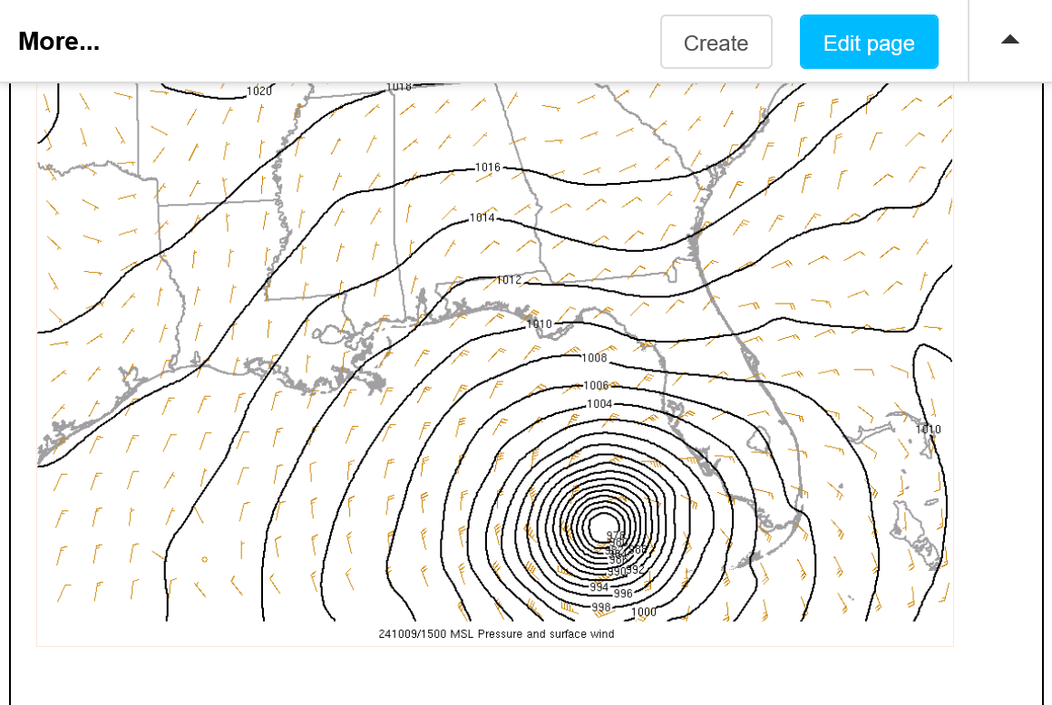
This is the constantly updated version:
https://www.marketforum.com/forum/topic/107854/#107919
There's only around 12 hours until landfall, so it will still be a VERY dangerous hurricane when it hits FL but probably not the storm of the century.
https://www.nhc.noaa.gov/text/refresh/MIATCDAT4+shtml/051459.shtml?
https://www.nhc.noaa.gov/refresh/graphics_at4+shtml/150217.shtml?cone#contents
https://wattsupwiththat.com/2024/10/08/ryan-maue-on-hurricane-hype/
++++++++++++
I would have no problem with a new cat. 6 hurricane category........except that it would be blatantly abused by the media to SENSATIONALIZE instead of INFORM readers/viewers.
Since the category never existed before to call previous cat. 6 hurricanes a cat.6, every time we had a hurricane reaching that intensity, there would be no perspective with the past and the headlines would be "first cat. 6 hurricane ever because of the climate crisis"
For instance, Milton briefly touched into the potential cat. 6 hurricane wind zone earlier this week. Can you imagine the already over sensationalized "storm of the century" headlines???
And what would that have accomplished?
Other than to scare the crap out of more people needlessly and to make them think the fake climate crisis caused it........making them scientifically dumber/LESS informed not MORE informed.
Milton continues to weaken as expected. Dropping below 120 mph at the moment and about to make landfall in the next several hours.
Major hurricane winds are 111+ mph and thats close to where Milton's top winds will be when making landfall in the continued weakening state.
++++++++++++
Would have made a much better president than the 2 on the ballet now and CRUSHED Harris......even if I don't agree with some of his agenda.
Tampa Bay NWS:
Making landfall just before 8pm CDT.
https://www.spc.noaa.gov/exper/mesoanalysis/new/viewsector.php?sector=18
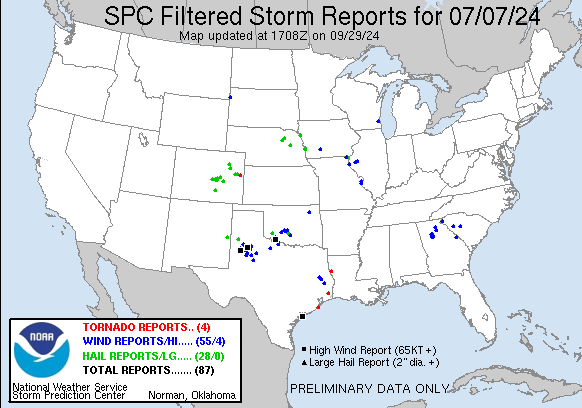
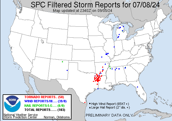
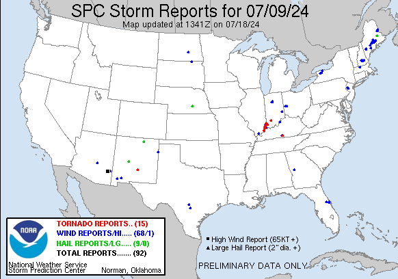
Why did Milton produce so many tornadoes?
46 tornadoes to be exact?
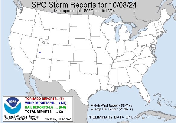
https://www.spc.noaa.gov/climo/reports/241009_rpts.html
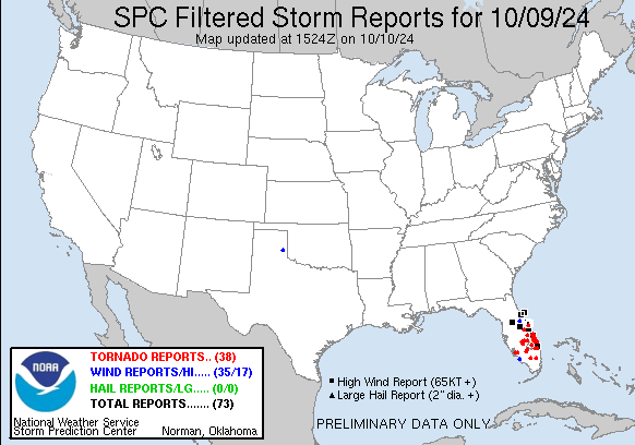
Let's first compare the number of tornadoes from Milton to the previous hurricanes this year to give you some perspective:
From Helene: 33 tornadoes:
https://www.spc.noaa.gov/climo/reports/240926_rpts.html

From Francine: 0 tornadoes:
https://www.spc.noaa.gov/climo/reports/240912_rpts.html
From Beryl: 79 tornadoes!
https://www.spc.noaa.gov/climo/reports/240707_rpts.html
A huge range in tornadoes from 0 in Francine to 79 from Beryl! Here's why!
Formation Ingredients
The key atmospheric ingredients that lead to tornado potential are instability - warm moist air near the ground, with cooler dry air aloft and wind shear - a change in wind speed and/or direction with height. An unstable airmass promotes the development of strong updrafts, while wind shear will further increase the strength of the updraft, and promotes the rotation from which tornadoes are produced.
+++++++++++++++++++
Every hurricane is loaded with warm, moist air near the SURFACE OF THE OCEAN.........it's what they feed on/what makes them.
The difference in this case was related to the JET STREAM/UPPER LEVEL WINDS (as well as the strength of the hurricane).
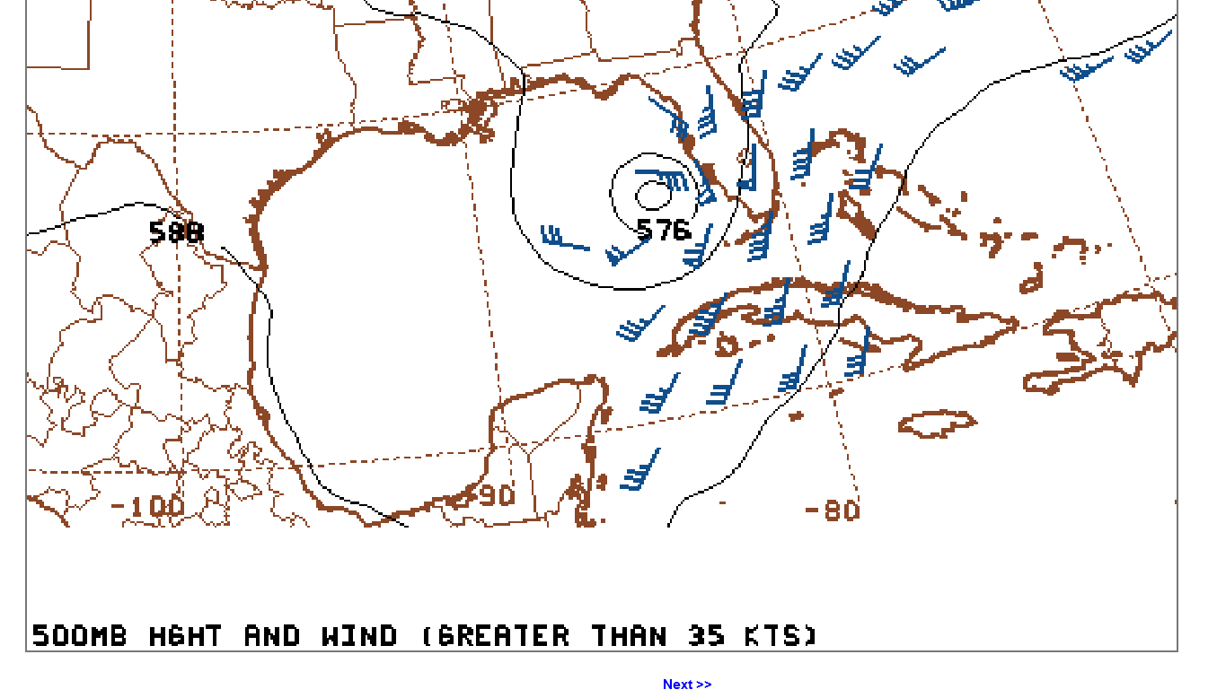
Here were some upper level wind charts from yesterday afternoon.
500 mb is around the 19,000 foot level.
200 mb is around 41,000 feet up:

1. We should note the HIGHER southwest winds aloft over Florida, ahead of the hurricane on Wednesday. This increased wind shear. In addition, this also had some drier upper level air that added instability to warm/humid, buoyant air rising from below. This was the biggest reason that Milton had more tornadoes than many hurricanes. Beryl had an even stronger jet stream that enhanced tornadoes WELL AFTER it had weakened and tracked far to the north. Several of them were up here in Evansville, Indiana 2 days after landfall.
2. Ironically, this is also, exactly what WEAKENED Milton on Wednesday. Hurricanes do best with no upper level wind sheer or drier air aloft. Strong to violent tornadoes MUST HAVE a strong jet stream! Weak tornadoes can form without it.
Here's a previous post related to that:
Re: Invest 92L SW Gulf: threat to W FL mid-week!
By metmike - Oct. 7, 2024, 12:43 p.m.
La Nina IS a major factor making it favorable for increased tropical activity in the Atlantic Basin because it suppresses wind shear that kills hurricanes. This is the biggest reason (along with warm water anomalies) for forecast tropical activity to be a record earlier this year.
El Niños have the opposite impact, INCREASING upper level winds and shear in the Atlantic basin that includes the gulf of mexico.
Hurricanes love a symmetrical wind pattern with height. If the winds aloft are much faster they tear the hurricane apart and cause the hurricanes vertical motions to be tilted with height, instead of maximizing the .transport of heat and moisture from a more symmetrical storm.
++++++++++++
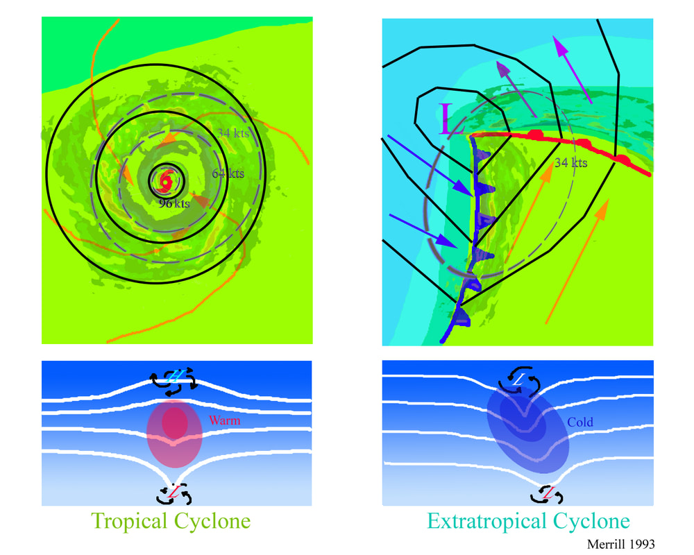
3. The physics/dynamics of a tropical system are much different than an extra-tropical system. A powerful jet stream in an EXTRATROPICAL storm contributes to it being STRONGER. A stronger jet stream or even modest upper level winds in a tropical system KILLS IT!
Here's some great explanations:
https://www.youtube.com/watch?v=ru5SX9n2qRk
https://www.alabamawx.com/?p=195936
Another reason for there to appear to be an extraordinarily large number of tornadoes with Milton is that the storm was greatly over hyped/sensationalized as the "Storm of the Century" by the media and others........which it wasn't .
Scroll up for a reality check on that.
Still more than 2 million people without power in Florida because of Milton's winds. You can see the path, from west to east below.
https://poweroutage.us/area/state/florida


OJ is up decently today. I wonder how much of this may be due to estimated damage to the FL orange crop being higher than what was dialed in to the price? Orange drop in concentrated grove areas of SW FL has reportedly/anecdotally been substantial.
Also, did Friday’s Oct USDA Production Report have a smaller than expected FL orange crop? Inquiring minds want to know!
Very interesting, Larry!
OJ was almost limit down on Thursday after Milton hit.
On Friday, it was the complete opposite, in fact after the bullish USDA report, OJ stayed LOCK limit up the rest of the session after trading to the limit a few times before the report.
the lock limit up close on Friday ensuredm a gap higher this morning.
we’re up around 14c now. Not sure what the expanded limit is but we won’t get close.
Milton damage probably has something to,do with it but FL production is small in 2024 compared to almost 10 times more 2 decades ago before citrus greening obliterated the orange groves.
sao paolo in Brazil produces 10 times as much OJ as us….but they’re having citrus greening issues are reducing their production, so supplies are historically tight….note the highest picea in history this year.
with such tight supplies, losses is FL would count more.
more on this when I return to my office.
 TBW Radar Loop