
Potentially devastating flooding for N Honduras similar to Eta/Iota of 2020 and Mitch of 1998 due to extremely slow movement: dire situation there

BULLETIN
Tropical Depression Nineteen Advisory Number   4
NWS National Hurricane Center Miami FL       AL192024
1000 AM EST Thu Nov 14 2024

...LIFE-THREATENING AND POTENTIALLY CATASTROPHIC FLASH FLOODING AND
MUDSLIDES EXPECTED IN HONDURAS THROUGH THE WEEKEND...


SUMMARY OF 1000 AM EST...1500 UTC...INFORMATION
-----------------------------------------------
LOCATION...15.7N 82.6W
ABOUT 225 MI...365 KM ESE OF ISLA GUANAJA HONDURAS
ABOUT 65 MI...100 KM NE OF CABO GRACIAS A DIOS ON NIC/HON BORDER
MAXIMUM SUSTAINED WINDS...35 MPH...55 KM/H
PRESENT MOVEMENT...W OR 265 DEGREES AT 14 MPH...22 KM/H
MINIMUM CENTRAL PRESSURE...1004 MB...29.65 INCHES


WATCHES AND WARNINGS
--------------------
CHANGES WITH THIS ADVISORY:

The government of Honduras has discontinued the Hurricane Watch for
Honduras and the Bay Islands.

SUMMARY OF WATCHES AND WARNINGS IN EFFECT:

A Tropical Storm Warning is in effect for...
* The northern coast of Honduras form Punta Sal eastward to the
Honduras/Nicaragua Border
* The Bay Islands of Honduras

A Tropical Storm Watch is in effect for...
* The northeastern coast of Nicaragua from Puerto Cabezas northward
to the Honduras/Nicaragua Border

DISCUSSION AND OUTLOOK
----------------------
At 1000 AM EST (1500 UTC), the center of Tropical Depression
Nineteen was located near latitude 15.7 North, longitude 82.6 West.
The depression is moving toward the west near 14 mph (22 km/h). This
motion should continue through today, bringing the center near the
coast of eastern Honduras. The system is expected to meander near
the northern coast of Honduras late Friday and through the weekend.

Maximum sustained winds are near 35 mph (55 km/h) with higher gusts.
Some strengthening is forecast and the system is forecast to become
a tropical storm later today.

The estimated minimum central pressure is 1004 mb (29.65 inches).
RAINFALL: Through early next week, rainfall amounts of 10
to 20 inches with isolated storm totals around 30 inches area
expected over northern Honduras. This rainfall will lead to
widespread areas of life-threatening and potentially catastrophic
flash flooding and mudslides, especially along and near the Sierra
La Esperanza.
Tropical Depression Nineteen Discussion Number   4
NWS National Hurricane Center Miami FL       AL192024
1000 AM EST Thu Nov 14 2024

Latest satellite imagery depicts that the system continues to become
better organized this morning, with improved curved banding
features, and deep convection consolidating near the low-level
center. The latest subjective intensity estimates were T/2.5 from
both TAFB and SAB. The initial intensity is set to 30 kt, and an Air
Force Hurricane Hunter aircraft is about to enter the system which
will provide more information on current intensity and structure.

The cyclone is moving westward with an estimated motion of 265/12
kt. A strong mid-level ridge located to the north of the system will
continue steer the system westward towards Central America. The
ridge is expected to break down, and the cyclone will meander in
weak steering currents, Friday through the weekend. This expected
slow motion will cause the system to produce heavy rains over the
same region, likely causing life-threatening flooding over portions
of Central America. By early next week, the mid-level ridge should
slide eastward over Florida, which should cause the system to move
northwestward across Belize and the Yucatan Peninsula. The NHC track
forecast is in good agreement with the various consensus models, and
is nudged slightly left towards the latest model trends.

Environmental and oceanic conditions are conducive for some
strengthening during the next day or so while the cyclone remains
over water. There remains uncertainty in how much land interaction
there will be with Honduras during the next several days, but the
model trends have been southward showing more interaction. If the
system remains along the coast or just offshore, it will likely
maintain intensity or slightly strengthen. However, if the
depression moves a little south of the forecast track, the system
could be weaker than shown below. Given the slight leftward track
adjustment with potentially more land interaction, the latest NHC
intensity forecast is lower than the previous and is near the middle
of the guidance envelope. However, it must be stressed that there is
still a lot of uncertainty in the intensity forecast.
FORECAST POSITIONS AND MAX WINDS

INIT  14/1500Z 15.7N  82.6W   30 KT  35 MPH
 12H  15/0000Z 15.7N  83.7W   35 KT  40 MPH
 24H  15/1200Z 15.9N  84.9W   40 KT  45 MPH...NEAR THE COAST
 36H  16/0000Z 15.9N  85.4W   40 KT  45 MPH...NEAR THE COAST
 48H  16/1200Z 15.9N  85.8W   40 KT  45 MPH...NEAR THE COAST
 60H  17/0000Z 16.0N  86.2W   45 KT  50 MPH...NEAR THE COAST
 72H  17/1200Z 16.2N  87.0W   45 KT  50 MPH...OVER WATER
 96H  18/1200Z 18.0N  89.6W   30 KT  35 MPH...INLAND
120H  19/1200Z 21.7N  91.6W   30 KT  35 MPH...OVER WATER

$$
Forecaster Kelly
Dec KC is up substantially today and has risen sharply this month to date. How much of the last couple of days of rises could be due to feared flooding in N Honduras? Anyone see any KC news stories addressing this storm’s potential? I suspect this is flying under the radar of the news reports for the most part but with some more knowledgable traders having gone long on the potential Honduras flooding. At first Eta was under the KC news radar.
Eta and then Iota, which both substantially damaged KC in Nov of 2020, along with at least one typhoon doing damage in Vietnam lead to KC substantially rising at some point in Nov. I remember clearly because I was long Dec calls/contracts then due to the wx.

NOW THIS IS WHAT I CALL A GREAT TRADING THREAD STARTED BY LARRY!
https://fas.usda.gov/data/production/commodity/0711100
| Market | % of Global Production | Total Production (2023/2024, 60 KG Bags) |
|---|---|---|
| Brazil | 39% | 66.3 Million |
| Vietnam | 17% | 29.1 Million |
| Colombia | 7% | 12.2 Million |
| Ethiopia | 5% | 8.35 Million |
| Indonesia | 5% | 8.15 Million |
| Uganda | 4% | 6.4 Million |
| India | 4% | 6.1 Million |
| Honduras | 3% | 5.3 Million |
| Peru | 2% | 4 Million |
| Mexico | 2% | 3.87 Million |
https://fas.usda.gov/data/production/commodity/0711100
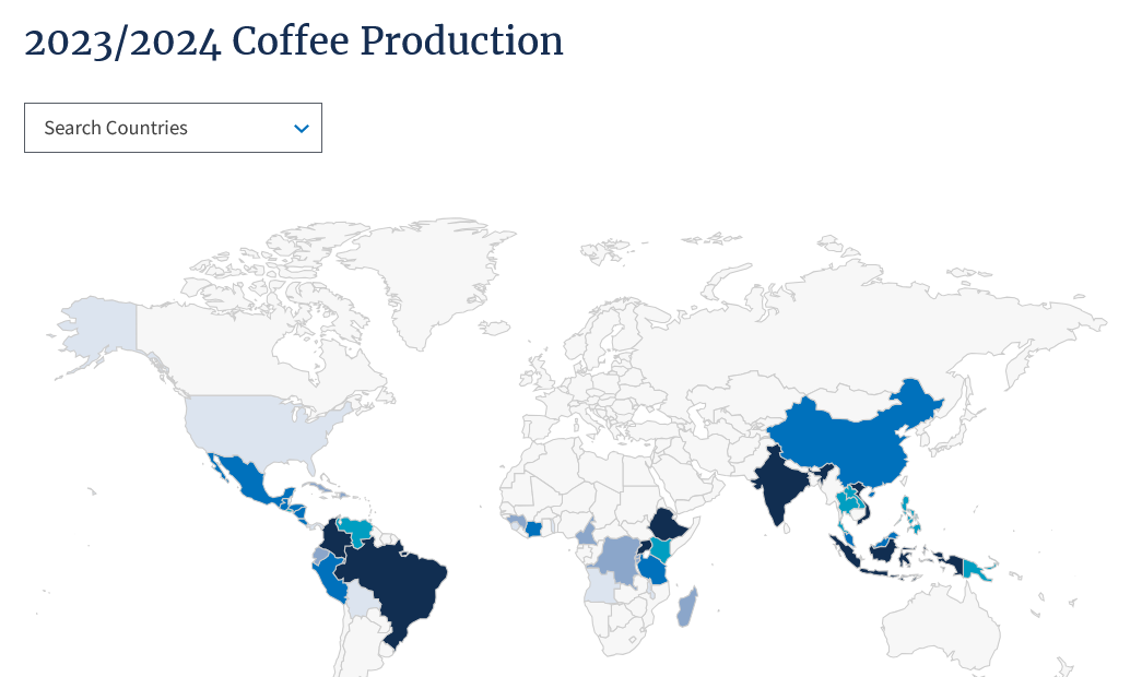
Thanks, Mike.
For those who don’t know: most of the KC produced in Honduras and nearby Guatemala is Arabica, which is what the actual US KC contract is based on. It is a high quality KC.
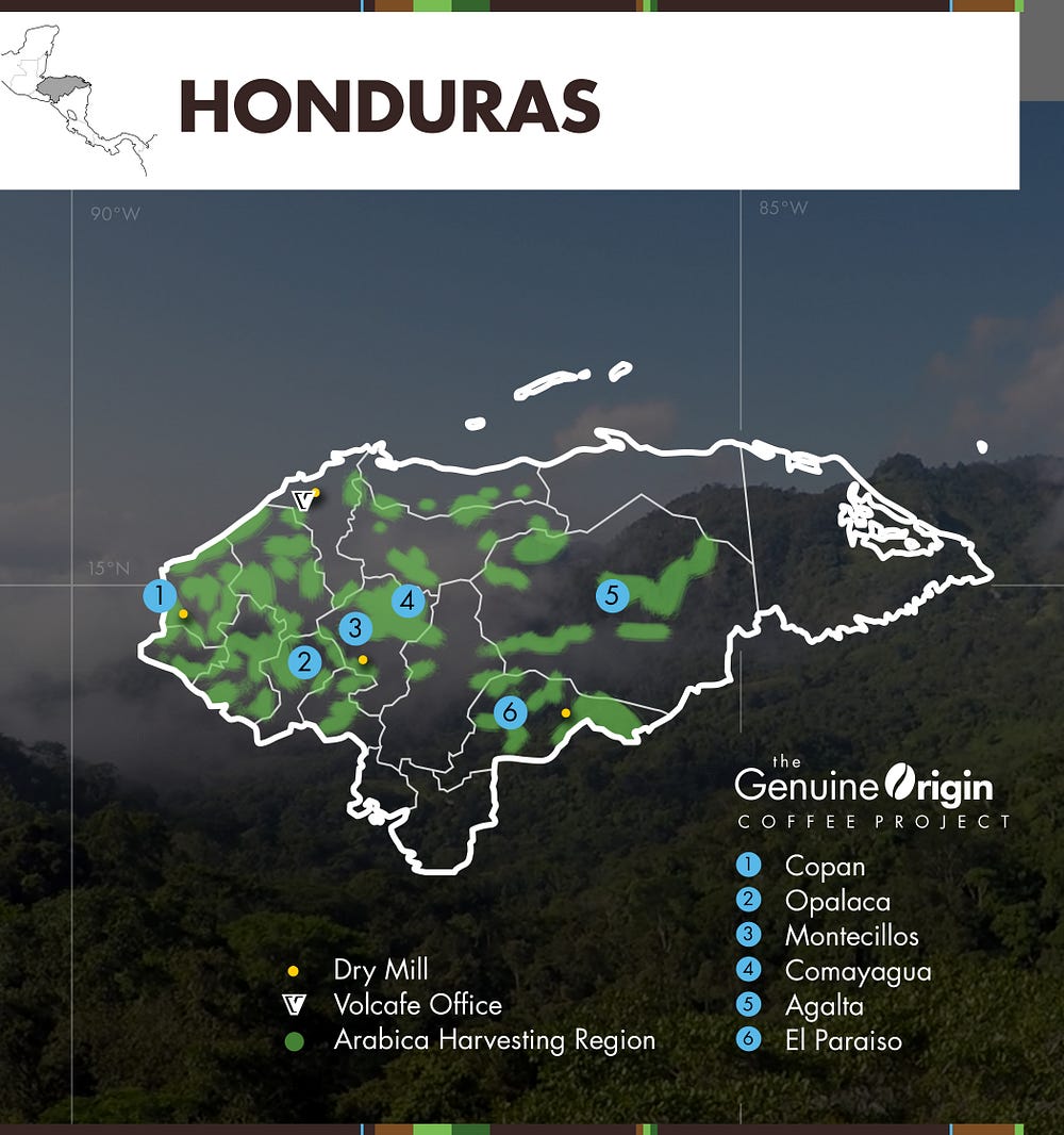
Honduras produces 3% of the global coffee. Where are the coffee trees located? If they are in southwest Honduras, then this is not a huge deal.
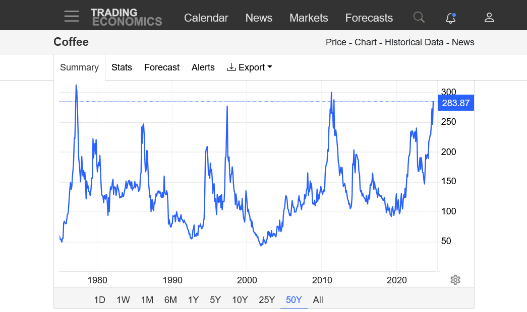
Global stocks must be extremely low because prices are near record highs.

It doesn't look like a great deal of production in the area with the heaviest rains(along and close to the coast)
https://blog.genuineorigin.com/2020/05/honduras-coffee-origin-report-2020/
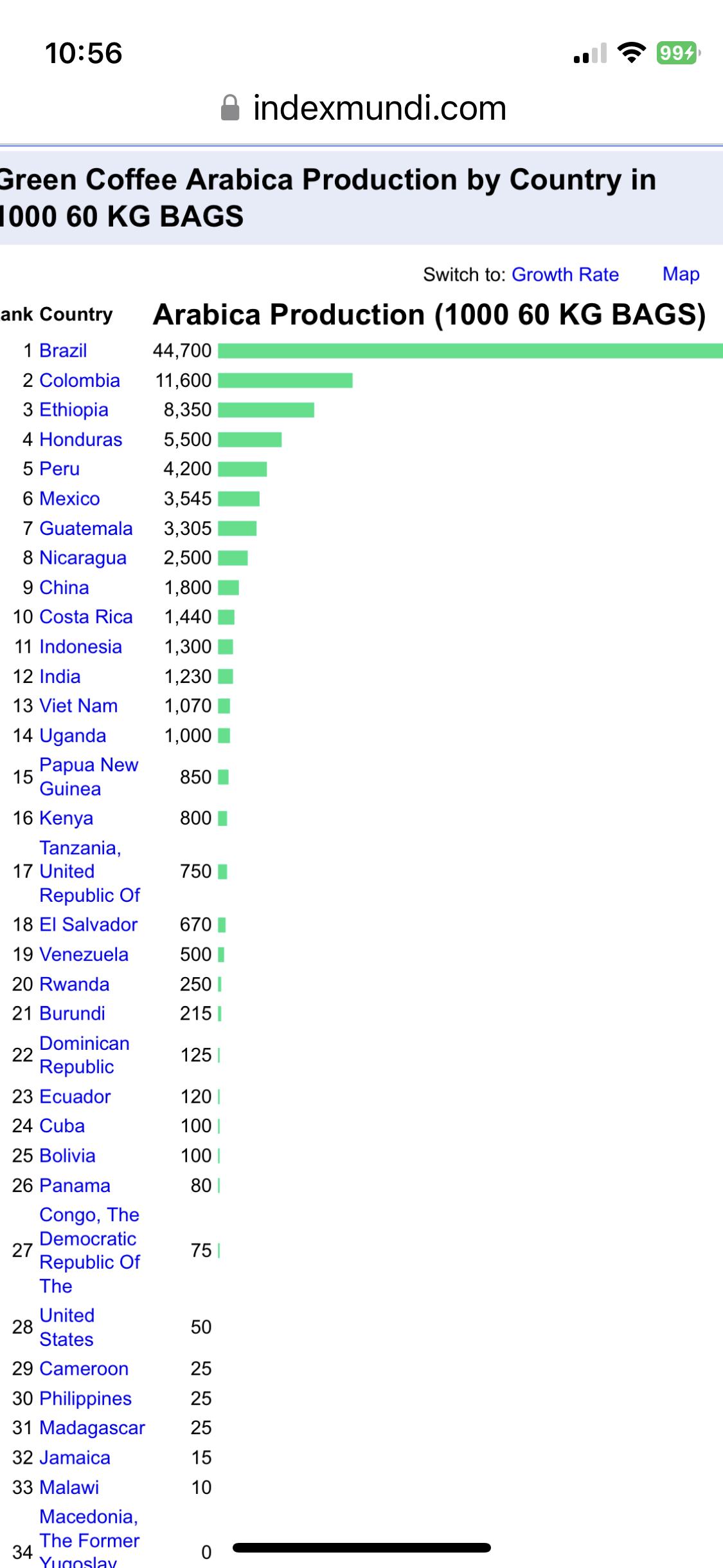
As mentioned in my last post, KC grown in Honduras is almost all Arabica, which is the KC grade traded on the US market. The following from the USDA in 2023 had Honduras with ~5.7% of the world’s Arabica production/4th in the world for Arabica volume produced at 5.5 million bags. So, it is at ~twice the % of global volume of Arabica vs volume as % of ALL global KC produced, which is ~3% as Mike noted:
This site does not mention the weather in Honduras as being a factor........just Brazil.
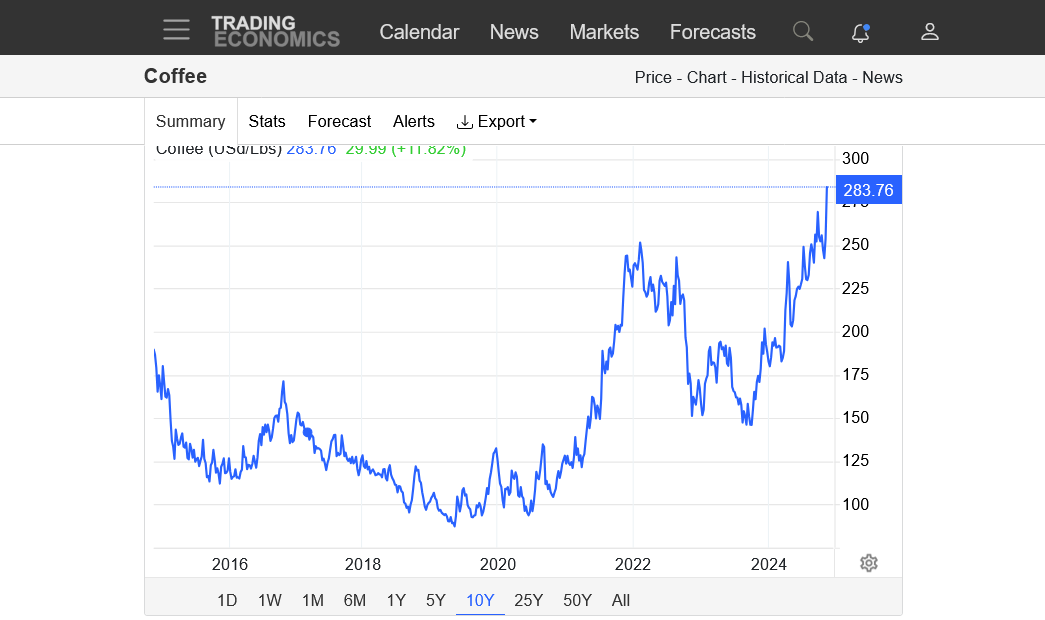
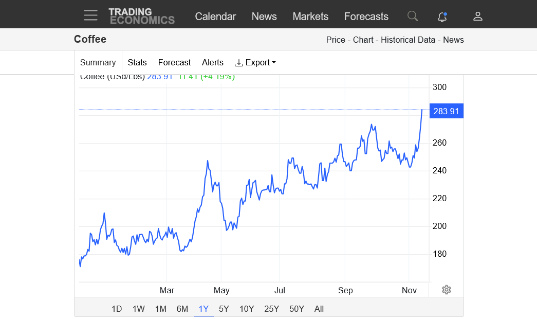
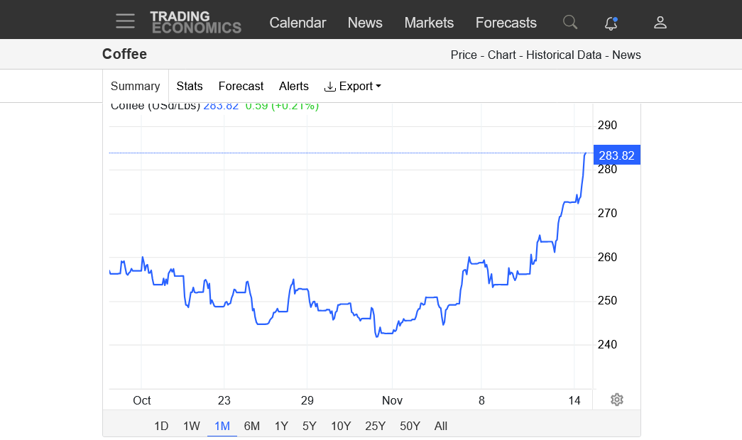
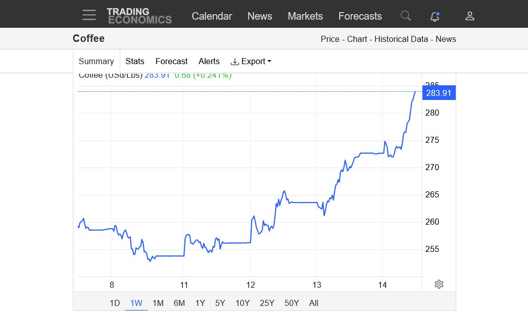
Coffee prices have almost doubled the past year and are near record highs.
https://tradingeconomics.com/commodity/coffee
1. 50 years
2. 10 years
3. 1 year
4. 1 month
5. 1 week
Previous coffee post-Brazil weather:
Soybeans/grains/coffee 11-5-24
14 responses |
Started by metmike - Nov. 5, 2024, 3:59 p.m.
https://www.marketforum.com/forum/topic/108473/
Brazil coffee 2 week rains. Pretty robust

Thanks, Mike!
Rainfall in Central America from Eta in 2020: 12”++ N Honduras with 5-12” much of C Honduras: forecasts for TD 19/Sara? are similar:
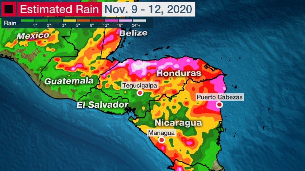
This was from BOTH ETA and Iota combined:
https://icocoffee.org/documents/cy2020-21/pr-313e-hurricane-iota-eta.pdf
Hurricane Iota was the second major hurricane to hit Central America in a matter of weeks. The first was Hurricane Eta which made landfall on 3 November 2020 as a category 4 storm, causing landslides and flooding that displaced thousands and left scores of people dead or missing. The damage to coffee-growing communities in the region is considerable. In Honduras, according to an initial assessment by CONCAFE (the National Coffee Council), the passage of Hurricane ETA and IOTA affected 60% of the coffee-growing municipalities and 14 of the 15 departments that produce coffee, totally damaging some 3,409 hectares and partially damaging 4,144 hectares of coffee farms. The impact on production is calculated to be 1.5% directly affected and another 1.5% is at risk in the partially affected areas . The assessment noted that there is a great risk that the harvest will not reach processing and export centres due to severe damage to roads and infrastructure. The main damage to infrastructure includes the impacts of landslides, roadblocks, damaged bridges or collapsed river crossings. Total production
lost due to the impact of the hurricanes is estimated to be approximately 3% of the exportable production forecast for the 2020/21 harvest, up to 200,000 60kg bags are at risk of lo
Hey Mike,
Thanks for that info. The production % losses were small. So, this is more of a psychological bullish factor, if at all. But also as your source said, infrastructure was devastated in much of the country causing extreme difficulty in transporting to processors and ports. Honduras is a big exporter of Arabica. I’m assuming that caused cash prices to rise a lot there in the short term.
TD 19 has become TS Sara: devastating rainfall in N Honduras and nearby is the main danger:
Tropical Storm Sara Intermediate Advisory Number 4A
NWS National Hurricane Center Miami FL       AL192024
100 PM EST Thu Nov 14 2024

...DEPRESSION STRENGTHENS INTO TROPICAL STORM SARA...
...LIFE-THREATENING AND POTENTIALLY CATASTROPHIC FLASH FLOODING AND
MUDSLIDES EXPECTED IN HONDURAS THROUGH THE WEEKEND...


SUMMARY OF 100 PM EST...1800 UTC...INFORMATION
----------------------------------------------
LOCATION...15.7N 82.9W
ABOUT 205 MI...330 KM ESE OF ISLA GUANAJA HONDURAS
ABOUT 50 MI...85  KM NE OF CABO GRACIAS A DIOS ON NIC/HON BORDER
MAXIMUM SUSTAINED WINDS...40 MPH...65 KM/H
PRESENT MOVEMENT...W OR 265 DEGREES AT 12 MPH...19 KM/H
MINIMUM CENTRAL PRESSURE...999 MB...29.50 INCHES
DISCUSSION AND OUTLOOK
----------------------
At 100 PM EST (1800 UTC), the center of Tropical Storm Sara was
located by Air Force Reserve reconnaissance aircraft near latitude
15.7 North, longitude 82.9 West. The system is moving toward the
west near 12 mph (19 km/h). This motion should continue through
today, bringing the center near the coast of eastern Honduras. The
system is expected to meander near the northern coast of Honduras
late Friday and through the weekend.

Data from the Air Force Reserve aircraft indicate that the maximum
sustained winds have increased to near 40 mph (65 km/h) with higher
gusts. Some strengthening is possible, if the system remains over
water.

Tropical-storm-force winds extend outward up to 70 miles (115 km)
from the center, mainly in the northern semicircle.

The estimated minimum central pressure based on dropsonde data is
999 mb (29.50 inches).
RAINFALL: Through early next week, rainfall amounts of 10
to 20 inches with isolated storm totals around 30 inches area
expected over northern Honduras. This rainfall will lead to
widespread areas of life-threatening and potentially catastrophic
flash flooding and mudslides, especially along and near the Sierra
La Esperanza.

Elsewhere across the rest of Honduras, Belize, El Salvador, eastern
Guatemala, and western Nicaragua, Tropical Storm Sara is
expected to produce 5 to 10 inches of rain with localized totals
around 15 inches through early next week. This will result in areas
of flash flooding, perhaps significant, along with the potential of
mudslides.
Assuming this story by CNN is accurate, this is very bad news for much of N Honduras being that heavy rains are forecasted to continue for parts of that area the next 24-48 hours:
“Tropical Storm Sara is unleashing heavy rainfall in northeastern Honduras, with life-threatening flash flooding and mudslides anticipated through the weekend.
Nearly 20 inches of rain had already fallen in parts of Honduras as of Friday morning with more to come.”
https://amp.cnn.com/cnn/2024/11/14/weather/tropical-storm-sara-florida-hurricane-season-climate
The following from NHC is regarding ADDITIONAL rainfall expected:
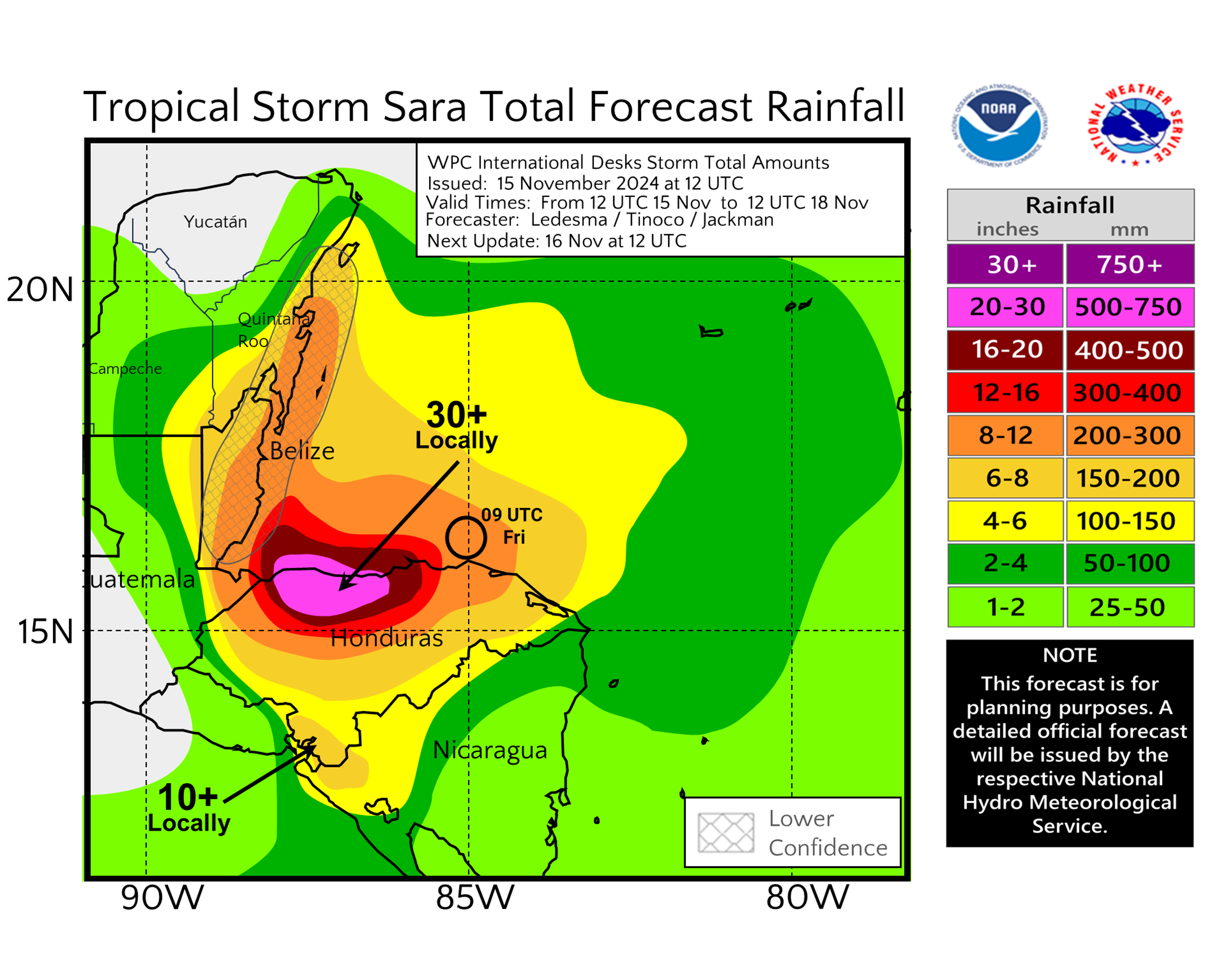
To compare here is the map released 24 hours ago: (the newer map looks worse to me for parts of N Honduras (though still mainly N of highest concentration of KC as Mike pointed out) even after considering it was for Thu AM til Sun AM vs Fri AM-Mon AM):
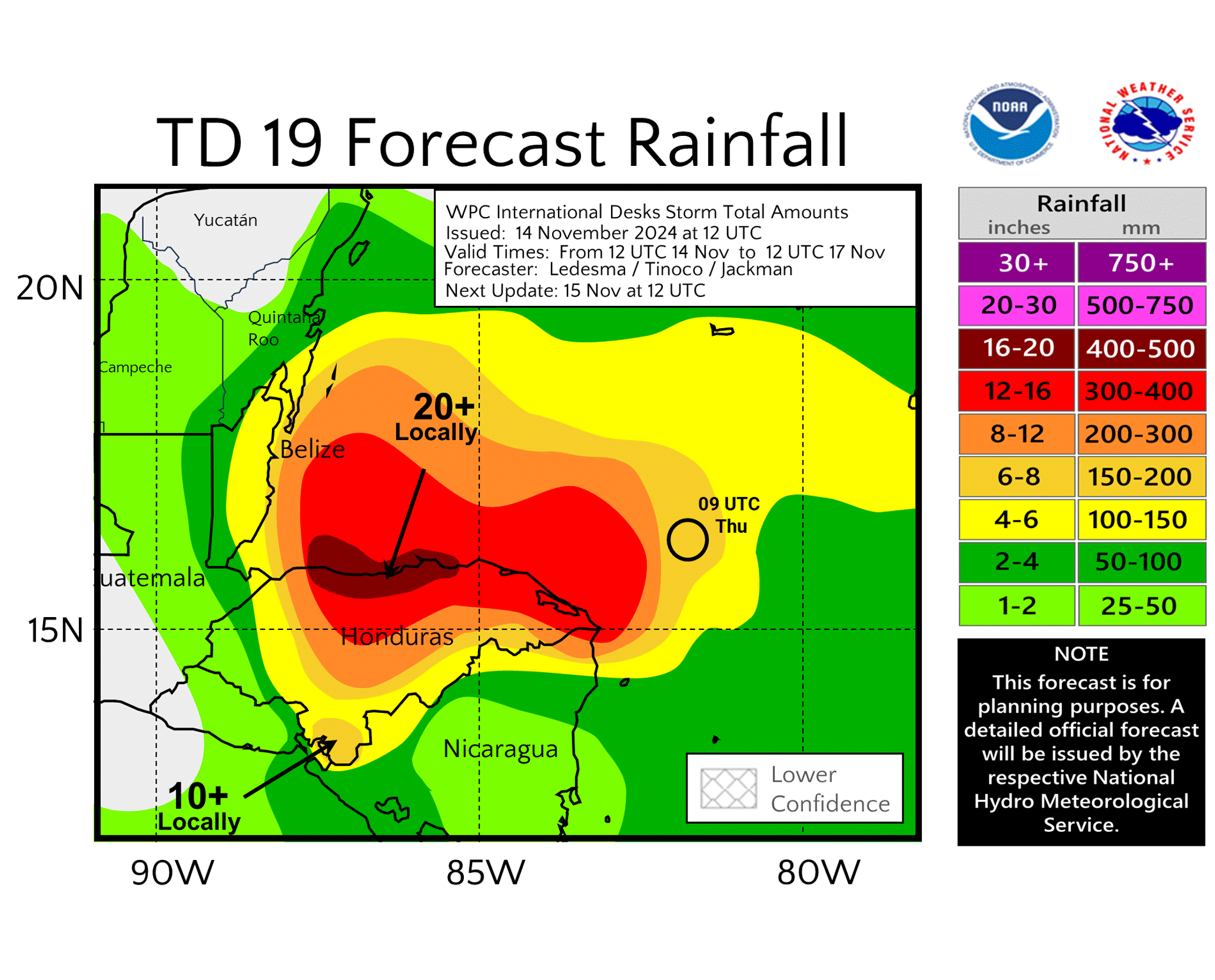
From the latest NHC forecast: probably about as dire as it can get there due mainly to very slow movement but also warmer than normal SSTs:
RAINFALL: Through early next week, rainfall amounts of 15 to 25
inches with isolated storm totals around 35 inches area expected
over northern Honduras. This rainfall will lead to widespread areas
of life-threatening and potentially catastrophic flash flooding and
mudslides, especially along and near the Sierra La Esperanza.
Compare that to the prior storm total rainfall forecast:
RAINFALL: Through early next week, rainfall amounts of 10 to 20
inches with isolated storm totals around 30 inches area expected
over northern Honduras.
La Ceiba, on the Caribbean coast of #Honduras, 556 millimeters (~22 inches) of rain in 24 hours ending this morning at 7 AM EST from Tropical Storm #Sara (via
, video from meteorologist Francisco Argeñal). More rain to come.
https://twitter.com/JohnMoralesTV/status/1857445789745684522?
Thanks, Larry!
From the latest NHC forecast: pray for portions of N Honduras (these are storm totals as most of the rain has already fallen) (main KC growing areas not getting near the heaviest):
RAINFALL: Through early next week, rainfall amounts of 15 to 25
inches with isolated storm totals around 40 inches area expected
over northern Honduras. This rainfall will lead to widespread areas
of life-threatening and potentially catastrophic flash flooding and
mudslides, especially along and near the Sierra La Esperanza.
Thanks, larry!
Thats an incredible amount of rain.
https://www.nhc.noaa.gov/text/refresh/MIATCDAT4+shtml/172035.shtml?