
Get all the constantly updated weather here:
https://www.marketforum.com/forum/topic/83844/
We have a MAJOR weather pattern change coming up in a few days. This thread and possibly more will focus on the many Winter elements as they approach.
One of the biggest, shocking changes will be the incredibly colder temperatures compared to the recent mild weather.
Our high in Evansville, IN on Saturday(2 days ago) was a balmy 60 degrees. During the 2nd week of January, we will have numerous days that are 40 degrees colder than that with subfreezing temperatures even during the day for numerous consecutive days.
The leading edge of the extreme Arctic cold from the "Siberian Express" looks like it will hit around january 6th. That will begin the period of a deep freeze and mostly subfreezing highs that may last until around January 14th, just over a week later.
Several mornings could feature low temperatures close to 0, especially around the January 9-14 period. That's with bare ground, which modifies cold a bit. Any snow on the ground and it could drop just below 0!
Update: HEAVY SNOW MAY HIT EVANSVILLE ON SUNDAY/MONDAY.
Most of the time, this extreme cold air will be extremely dry too without any perturbations to trigger significant snow. However, a reinforcing cold front could drop an inch or 2 of fluffy dry snow.
The exception to that is a system hitting early next week WELL BEFORE the frigid air arrives.
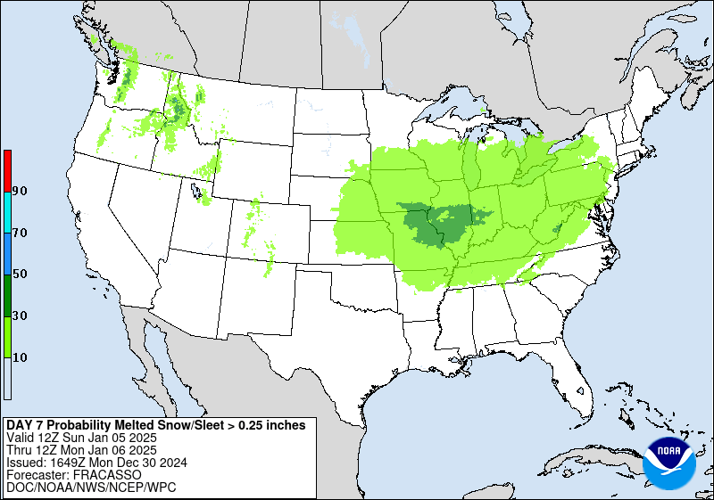
It's around 6 days from now (1-5-25), so alot will change...but you've been advised early!
This was a freeze frame of the last forecast map below. Go to the link to see the latest updates. Each day as it gets closer, it will appear in the forecast for the day earlier.
Winter Weather Forecasts
https://www.wpc.ncep.noaa.gov/wwd/winter_wx.shtml
https://www.wpc.ncep.noaa.gov/wwd/pwpf_d47/pwpf_medr.php?day=7
++++++++++++++
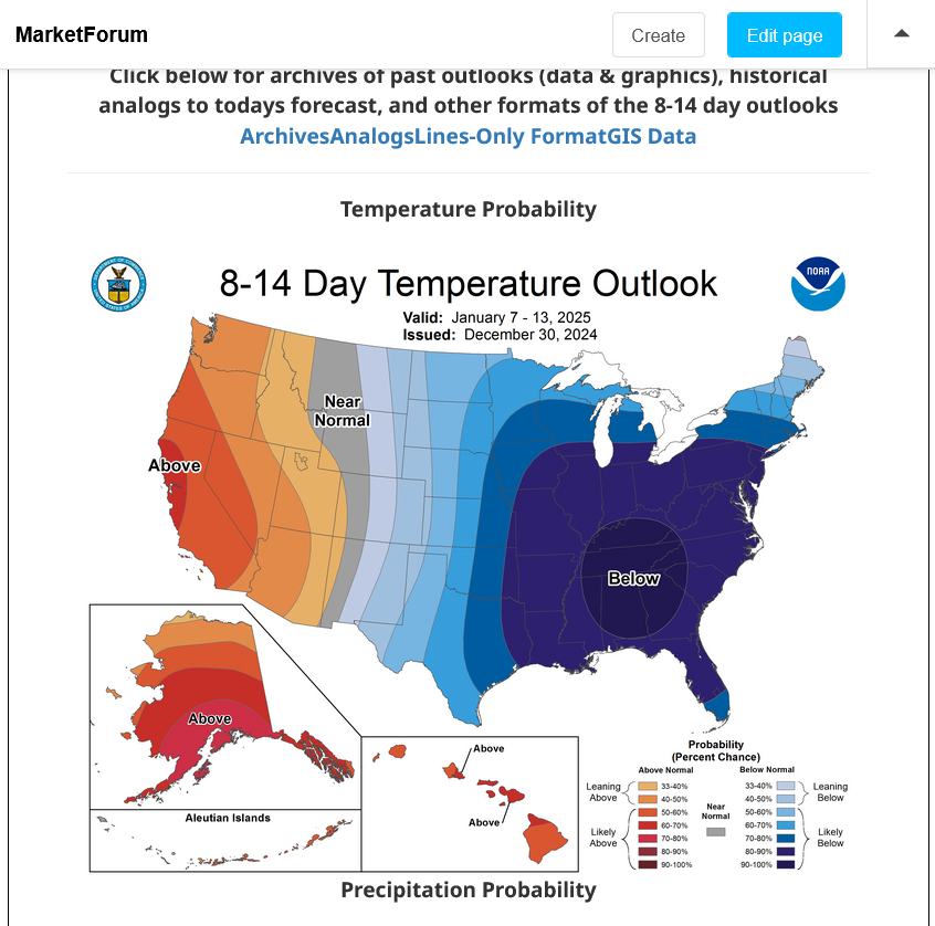
The cold part of the forecast is a 100% certainty.
This was the latest 8-14 day forecast for the period we'll be focused on in this thread and others to follow:
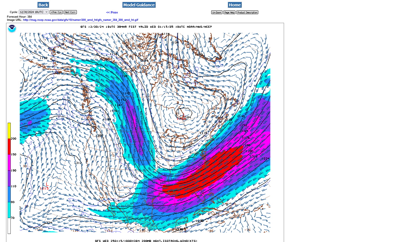
This is what the jet stream will look like at 200 mb, late NEXT week. This is around 35,000 feet above the ground.
The air with these steering currents tends to follow the streamlines. Although this map only shows our side of the northern hemisphere, these streamlines are originating in Siberia! They are transporting air FROM SIBERIA which is crossing the Arctic, crossing Canada and being dumped deeply into the United States! We call this CROSS POLAR FLOW.
Siberia is a huge land mass with 24 hours of darkness and constant cooling at this time of year. This is where the COLDEST air on the planet usually comes from at this time of year.
Note the red L in Southern Canada at the southern tip of the Hudson Bay. That's the POLAR VORTEX, which will be displaced well over 1,000 miles farther south from its typical January position in the high Arctic because of this extreme weather pattern. This is NOT caused by climate change but by an extreme pattern which we expect to see because of natural variability. It's probably happened close to 100 times before in my 69 years.
Here's a tutorial:
THE 300 / 200 MB CHART
https://www.weather.gov/source/zhu/ZHU_Training_Page/winds/JetStream_Stuff/300_200_chart.htm
++++++++++++++
Get all of Jeff's tutorials here:
METEOROLOGIST JEFF HABY
theweatherprediction.com
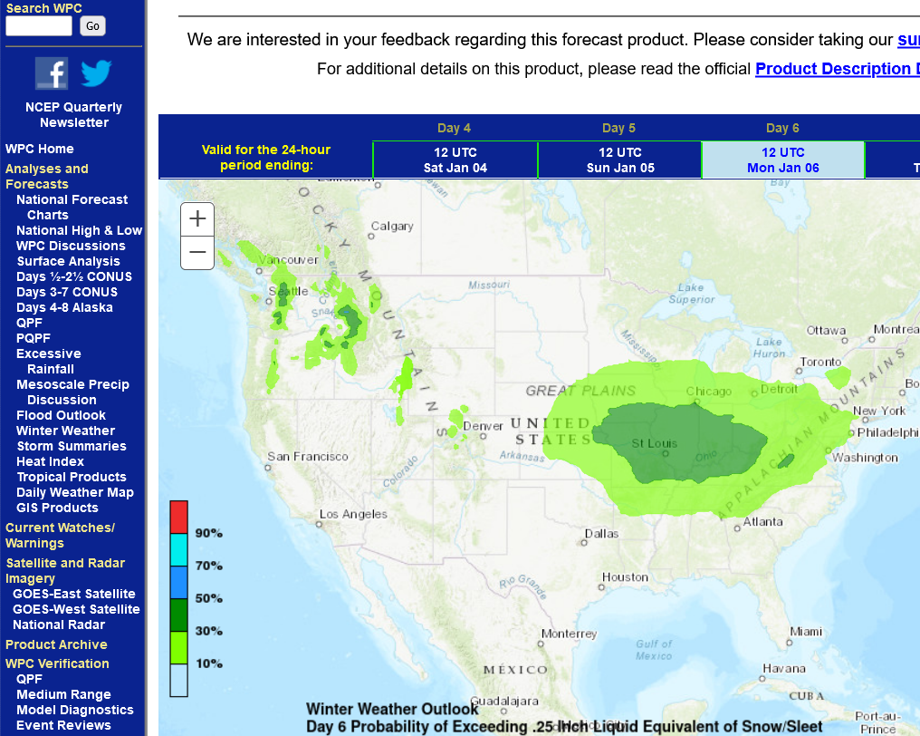
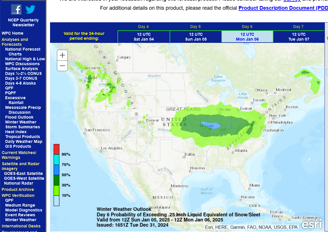
The Winter Storm is getting 1 day closer with today's update bumping it up to day 6 from yesterdays day 7.
Winter Weather Forecasts
https://www.wpc.ncep.noaa.gov/wwd/winter_wx.shtml
https://www.wpc.ncep.noaa.gov/wwd/pwpf_d47/pwpf_medr.php?day=6
The 12z Tuesday morning guidance is turning this into a MAJOR Winter Storm, hitting Evansville, starting on Sunday, January 5th!
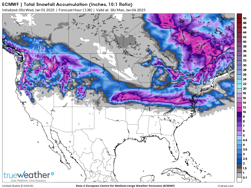
This was the total snowfall forecast from the 12z GEFS, starting early Sunday and ending very early Monday morning.
The darker, 3rd shade of green in the center is the 4+ inch band of total snow, which tracks close to Evansville. This is a big increase from forecast amounts from 24 hours ago. Each model run since then has been increasing snow amounts. It's bound to change more with the event still almost 5 days away.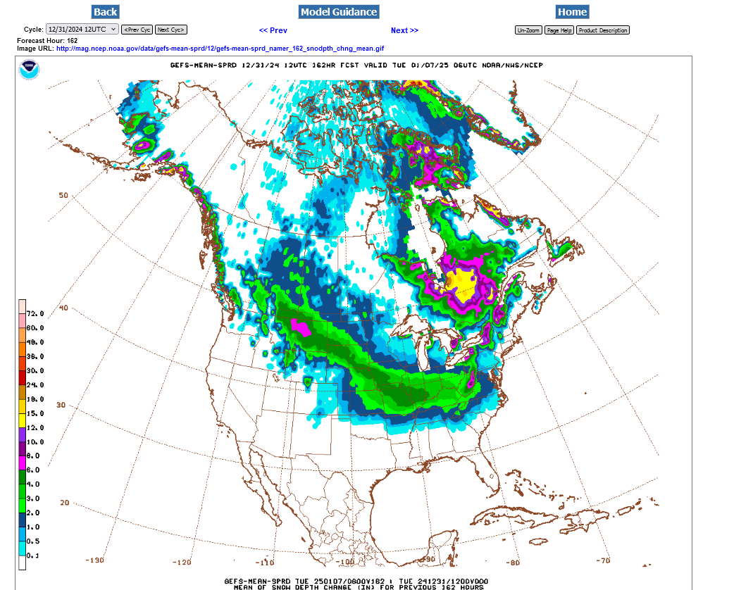
+++++++++++++++++++++++++++
3pm update: The NWS is also increasing their chances for this day 6 snow/sleet event. I'm expecting them to continue to increase these odds as we get closer. Sunday and Sunday Night look like the time frame!
I have a few hundred teachers on our chess emails lists from 5 schools that are using this link and I love to stick my neck out on how this might impact school. In this case, it looks like the Winter Break will spill over to at least next Monday because of a snow day. Temperatures will be close to freezing when most of it falls, so plowing, then salt on the MAIN roads will be effective. However, a heavy snow on unplowed sidestreets will be a problem when the DEEP FREEZE HITS ON MONDAY NIGHT AND TUESDAY AND CAUSES EVERYTHING TO FREEZE UP. This has the "potential" of creating dangerous travel for school buses on sidestreets and unplowed roads for several days next week which could extend the Christmas Break for numerous days. Just some early speculating not forecasting.
https://www.wpc.ncep.noaa.gov/wwd/pwpf_d47/pwpf_medr.php?day=6
+++++++++
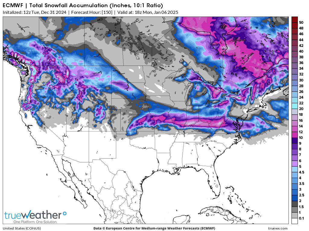
Its way too early to have any confidence in something like this but a couple of the models turn this into a mega snowstorm. This was the last 12z European model below.
Impossible to make it out exactly on your screen but the epicenter/bullseye color representing the heaviest snow band in Southern Indiana is 16 inches.
+++++++++++++++++++++++++
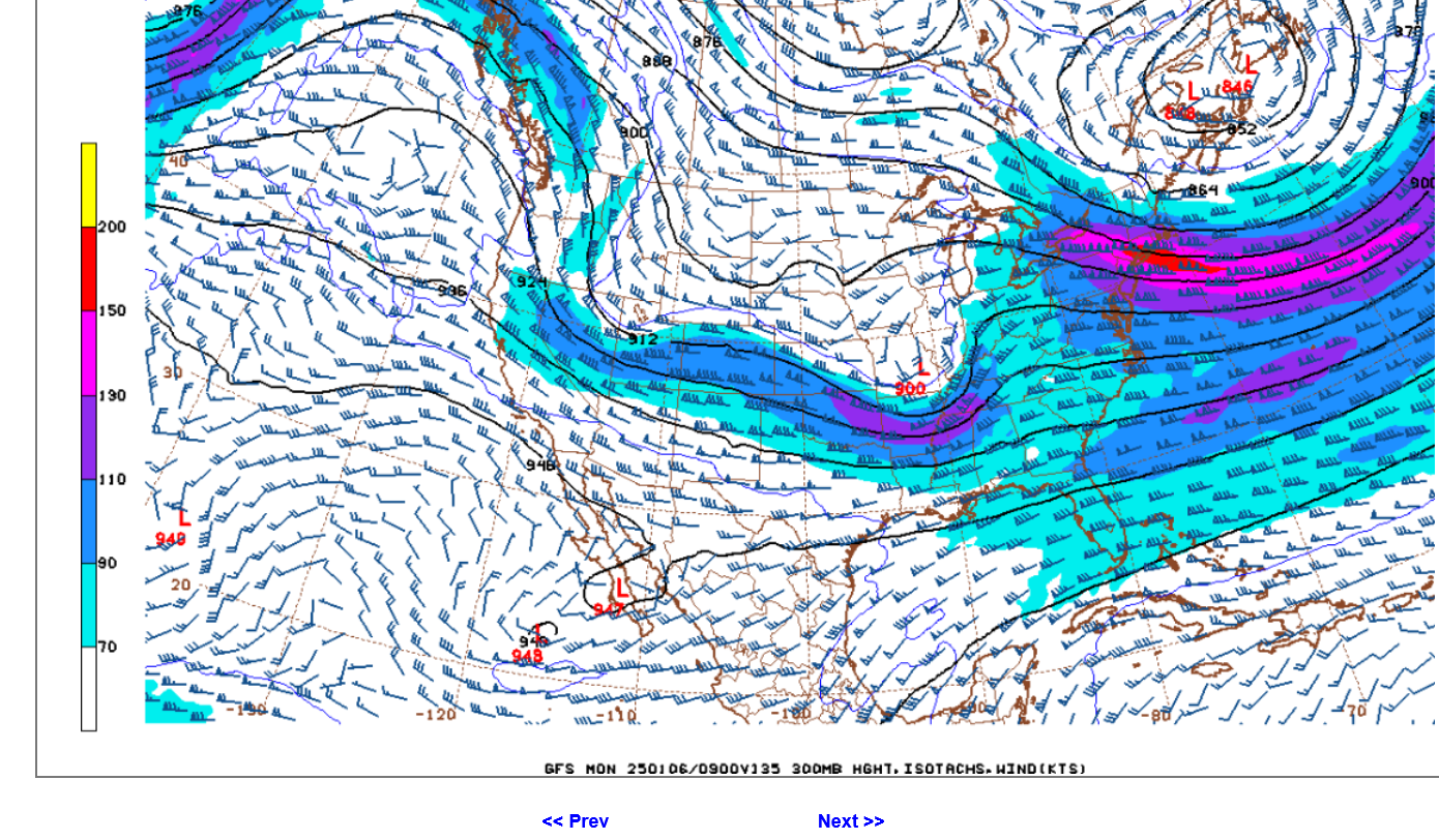
Looking at the upper levels below for next Monday, there is excellent support for a foot of snow IF this solution has the right idea.
At 250 mb: A small cut off low to our west. Powerful jet streak at 35,000 feet with a max of 130 knots=150 mph. We are in the left/front quadrant of the jet streak where it causes upper level divergence and lift/rising air below it. The greater the lift, the more moisture condenses out as snow(below freezing).
HABYTIME MINI LECTURE 26:
QUADRANTING A JET STREAK
http://theweatherprediction.com/habyhints2/601/
+
++++++++++++++++++++++++
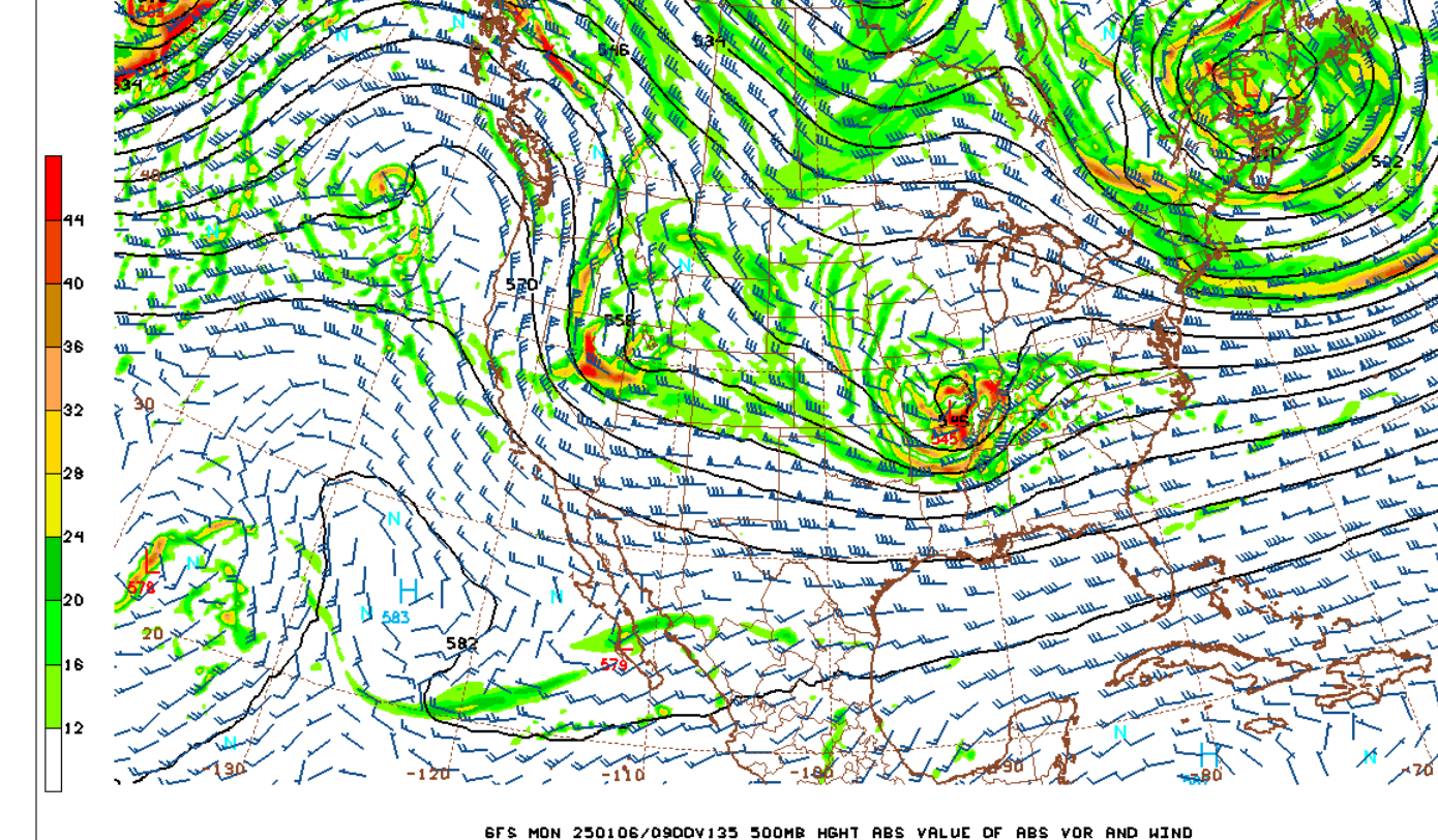
Very potent, focused positive vorticity advection pattern at 500 mb or around 15,000 feet. This creates counterclockwise spin and lift. Small cutoff low to our west.
Vorticity Basics
https://www.weather.gov/source/zhu/ZHU_Training_Page/Miscellaneous/vorticity/vorticity.html
For your interest and learning:
| GENERAL WINTER PRECIPITATION FORECASTING |
METEOROLOGIST JEFF HABY
CATEGORY A. MID-LATITUDE CYCLONE WINTER STORM
++++++++
| THE WINTER PRECIPITATION FORECAST |
METEOROLOGIST JEFF HABY
https://www.theweatherprediction.com/habyhints/71/
+++++++++++++
| HARD TO FORECAST: SNOW ACCUMULATION |
METEOROLOGIST JEFF HABY
https://www.theweatherprediction.com/habyhints3/915/
+++++++++++++++
metmike: Winter Storms have always been my favorite weather going back 6+ decades. I remember being a young child that would stay up all night waiting for and watching the snow. Now approaching 70 years old, they are even MORE exciting, being armed with 1 million times more data to use than the 1960's. Back then, watching the weatherman on tv and looking out my bedroom window. Having an atmospheric and oceanic science degree from The University of Michigan was nice too.
Still remember the phone number to get the NWS weather recording numerous times/day, starting in 2nd grade (using a party line) in Detroit Michigan. W-E-A-T-H-E-R !
Dad took me for a private tour with the NWS meteorologists at Metro Airport(DTW) in Detroit when I was 10!
He was the best Dad!
A tribute to our Dad, Frank Maguire 9-16-1925 to 11-21-2024
24 responses |
Started by metmike - Nov. 22, 2024, 2:04 p.m.
The models have changed some elements of the storm related to the vertical temperature profile. Previously, they had a well defined rain/snow line, with us barely on the north side of that, where the heaviest snows usually are. Not much sleet or freezing rain.
Now, it's a big mess and we are in the middle of it. When there's alot of sleet/freezing rain that falls, it always cuts down on the total snow accumulations. So the forecast challenges are several.
1. Track of the surface storm and surface temperatures
2. Track of the storm in the upper levels and upper level temperatures
3. Vertical temperature profile (deduced from #1 and #2) and length of time for different thermal conditions.
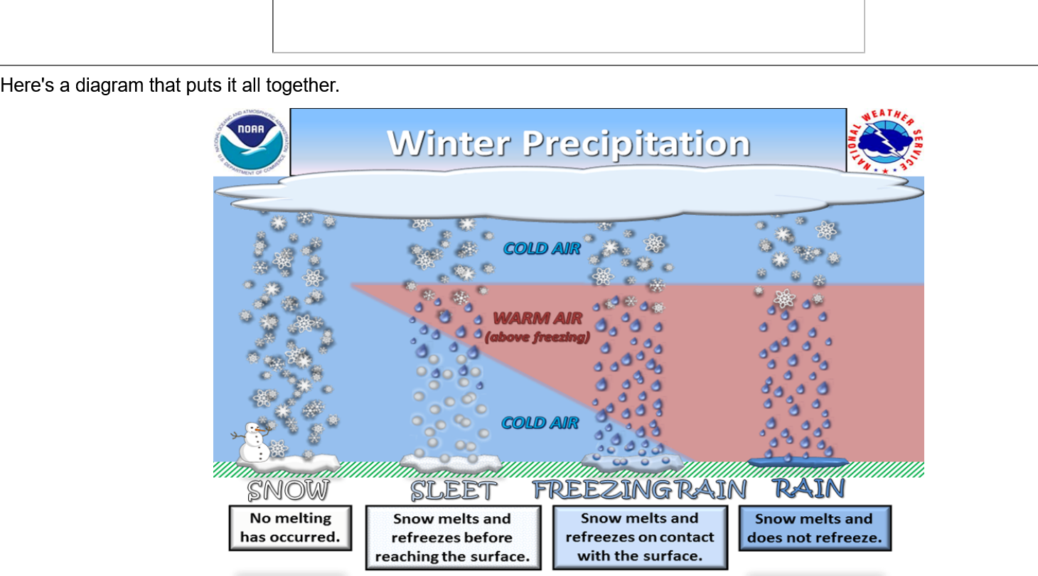
a. A below freezing surface with a shallow above freezing layer above it = freezing rain= rain that freezes AFTER hitting the ground.
b. A warm pocket aloft/above freezing, with a thicker layer of cold above the surface/below freezing = sleet/ice pellets(rain freezing BEFORE reaching the ground).
c. Below freezing all the way down to close to the surface = snow. Snow can fall up to 35 Deg. F, if that +freezing condition is hugging the surface and it's -freezing elsewhere.
4. Amount of moisture available
5. Amount of lift to generate condensation of the moisture
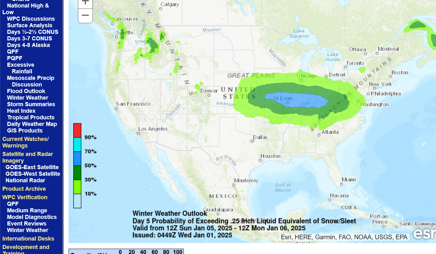
As is typical of the very conservative NWS, they are just now updating their day 5 map to 50%+ chance with a gradually increasing probability of this Winter Storm as it gets closer. Personally, I would have the chances of it at 95% but the HUGE problem is WHERE not IF.
https://www.wpc.ncep.noaa.gov/wwd/pwpf_d47/pwpf_medr.php?day=5
+++++++++++++++++
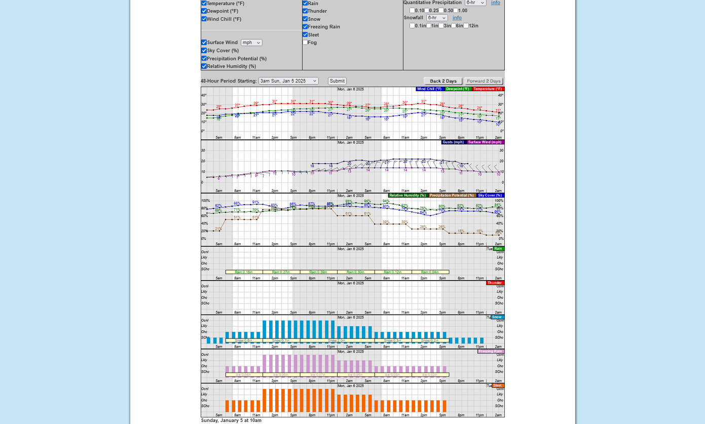
You can go to the local NWS and get a numerical prediction with an hourly breakdown of every weather element here.
I zoomed in with the 2nd chart/graph to closely show the computer prediction of precipitation type. You can see how its a combination of rain, freezing rain, sleet and snow. Yesterday, this same chart had it all rain or all snow. The trick for a meteorologist in 2024, is to do BETTER than this computer forecast because a child in elementary school can be taught to read/interpret this graph and use it for a weather forecast. With that being the case, this graph is extremely useful for people that want to quickly ascertain hour by hour conditions.
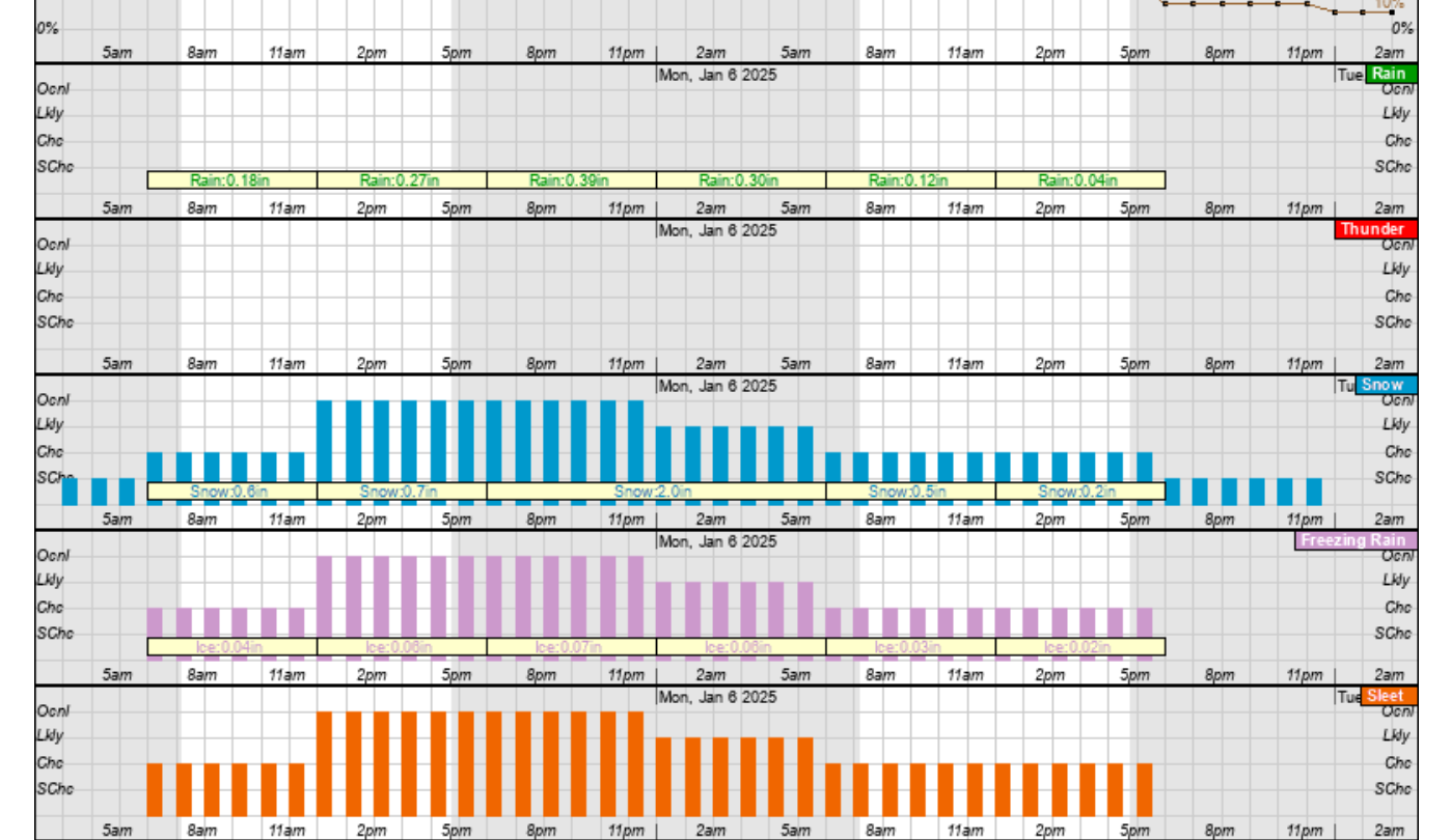
Note, that at the bottom of each category, the graph shows 6 hour totals for amounts.
++++++++++++
This data was for Evansville in the Paducah forecast area of responsibility. To get data from other regions, you can go to this link:
https://www.nws.noaa.gov/organization.php
Even better, go to this map and hit the county you are interested:
The last 0z European model continued to be the most aggressive with snow amounts but that model has shifted everything a smidgen to the north(less than 20 miles) and not quite as heavy but still HEAVY.
Evansville is on the EXTREME southern edge of the very heavy snow. IF this verified, places right along the Ohio River in far southwest IN, might get close to 5 inches of snow.
50 miles south of that= 1 inch of snow
50 miles north of that = 14 inches of snow
Weather models are not capable of pinpointing the exact location of things like this 4 days before hand.
At this point, Evansville still could get a foot of snow............or just minor accumulations. Then, there's the problem of how much might fall as sleet that would substantially cut back on snow amounts. Along and just south of the Ohio River, there might be much more sleet than snow?
Addition: I just looked at a vertical temperature profile from the last run or the 6z GEFS that jumps out at me. It brings up enough warmer air for numerous hours to change everything to plain rain in Evansville when the intensity is heaviest.
I'm now leaning towards the heavy snow being just north of Evansville with 4 days to go. There could be a ton of sleet and freezing rain for us.
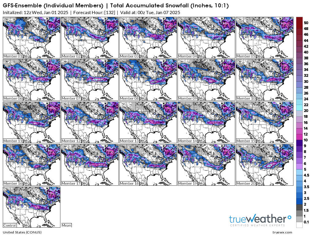
The just out 12z GEFS products has increased total snow amounts for this storm. One of the products, is an ensemble with dozens of members/solutions that change/perturb 1 parameter in the thousands of equations slightly(because the equations are not perfect) to see how it might impact the solution. This gives us a range of possibilities and is like having a person with an unknown illness and 30 different doctors, each with a different viewpoint give their diagnosis.
This is what the first 20 "weather model doctors" of this last 12z GEFS came up with for total snow amounts. Note the bottom left solution. This was the solution of the main, operational GFS model.
What does this tell us?
With extremely high confidence there will be a lengthy, mostly west to east(but northwest to southeast in some solutions) band of heavy snow.
A slight majority of solutions have the heaviest snow just north or northwest of us...but some have it almost on top of us or even a bit south. The majority/average have the best skill over time but we can't rule out what's on a significant minority of solutions.
This is for SNOW only. Just south of the heaviest snow, there's likely to be a period of several hours with HEAVY SLEET or even freezing rain that cuts down on the heavy snow accumulations. This last run was actually a tiny bit COLDER than the previous run, so I'm dialing back my thoughts about it warming enough for plain rain for several hours from the last page.
This is the best way to forecast weather AND to trade commodities. NEVER get married to a forecast or position. Change immediately, at the first indication that you were wrong before. Admit you were wrong and quickly make an even BETTER forecast or take an even better position for success!
It applies also with chess. The most important move of the game..........is often what your opponent did last. Be ready to adjust your plan according to how their moves impact the game as it progresses.
This is still 4 days away(Sunday Morning). Almost no chance that the locations and amounts will not change. However, this Winter Storm is a done deal as far as whether it will happen or not and its just a question of the details for us.
Below was the AVERAGE of all the GEFS model solutions above(Evansville gets 8+ inches).
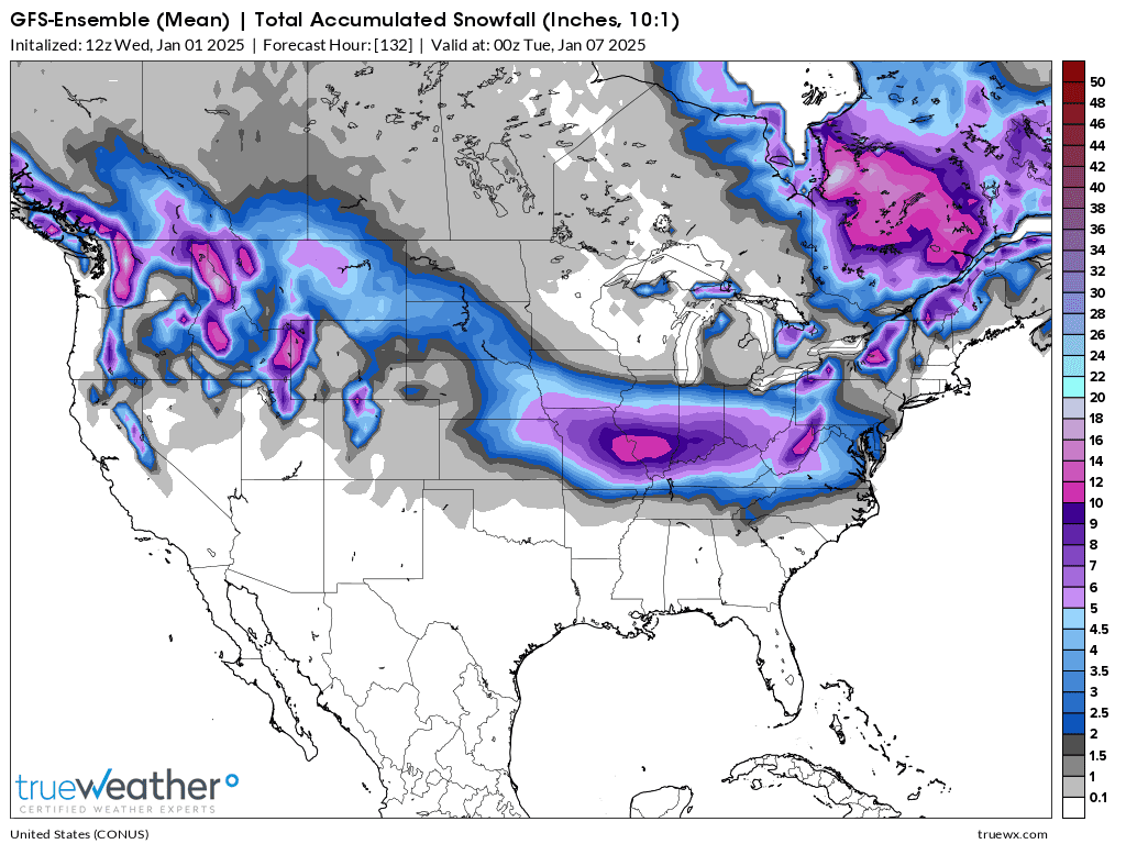
It's hard for me to conceive there being school next Monday. How hard it hits will determine the rest of next week because the coldest air in a couple of years will follow later in the week.
https://www.marketforum.com/forum/topic/83844/#83851
With any type of snow on the ground, that keeps cold blasts from moderating as much, I believe we will have a couple of early morning lows BELOW 0 later in the week! Especially in the areas that receive the heaviest snow.
This last 12z European model has made a slight but significant shift northward for the heaviest snow totals. This shows Evansville with, maybe 3-4 inches of snow and probably a lot of sleet. Central IN has the highest totals, just under 10 inches on this run.
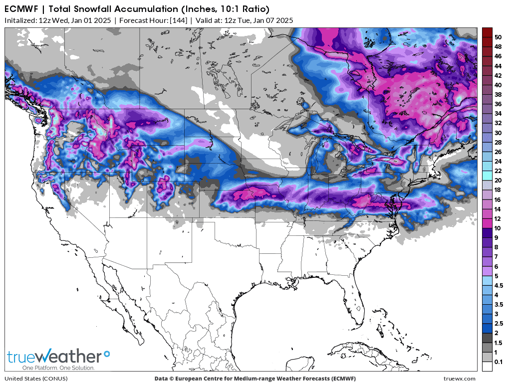
+++++++++++++++++++++++
The European Ensemble, an average of 50 European model solutions gives us just under 5 inches of snow below. A significant minority have almost all the snow north of us. Waaaay too early to believe it. Considering the steep snow forecast gradient, we could still get 12 inches as much as we could miss most of the snow to our north.
Near 100% chance of the event hitting Indiana!
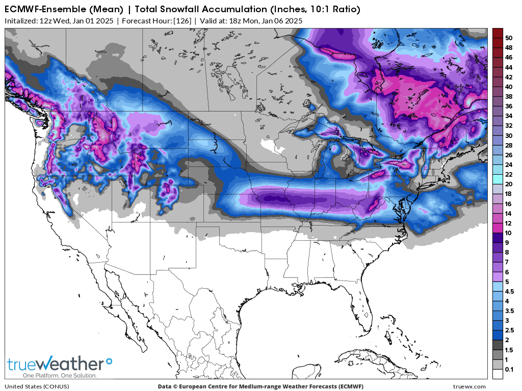
This was the last 18z GFS forecast. The dark red is 8+ inches.
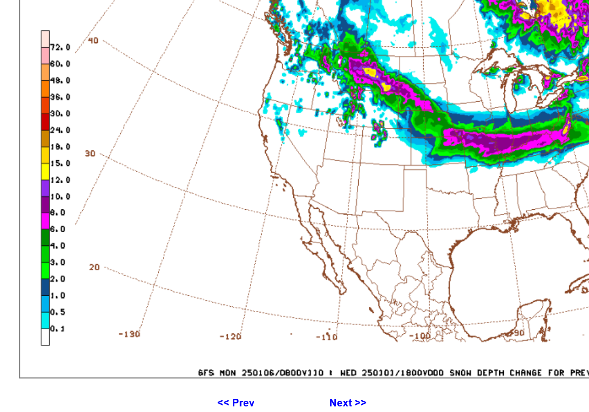 Midnight 1-2-25:
Last 0z GFS. The yellow is 12+ inches. Evansville is on the far southern end of the heavy snow(just barely)
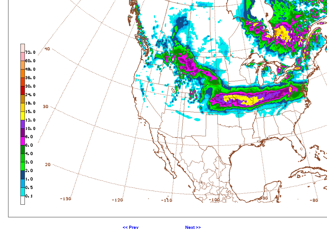
0Z European model below. Pink is 10+ inches. Even the tiniest shift north will take out most of our snow, with mostly sleet and some freezing rain instead. 3.5 days to go.
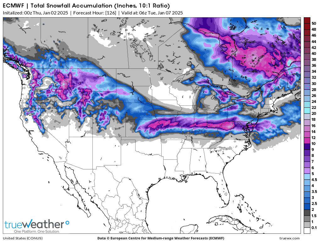
NWS finally has a 90% chance, now in day 4 alert. As if we didn't know it was this high earlier in the week.
https://www.wpc.ncep.noaa.gov/wwd/pwpf_d47/pwpf_medr.php?day=4
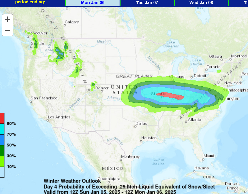
The last 6z GEFS still has the southern edge of heavy snow over us but I'm starting to lean a bit farther NORTH and even the chance for several hours of plain rain Sunday afternoon. This would be after starting as snow, transitioning to sleet, then RAIN, then back to snow. Hard to imagine school on Monday. Frigid blast for mid/late week with 100% confidence. More comments in a few hours after the 12z guidance is out.
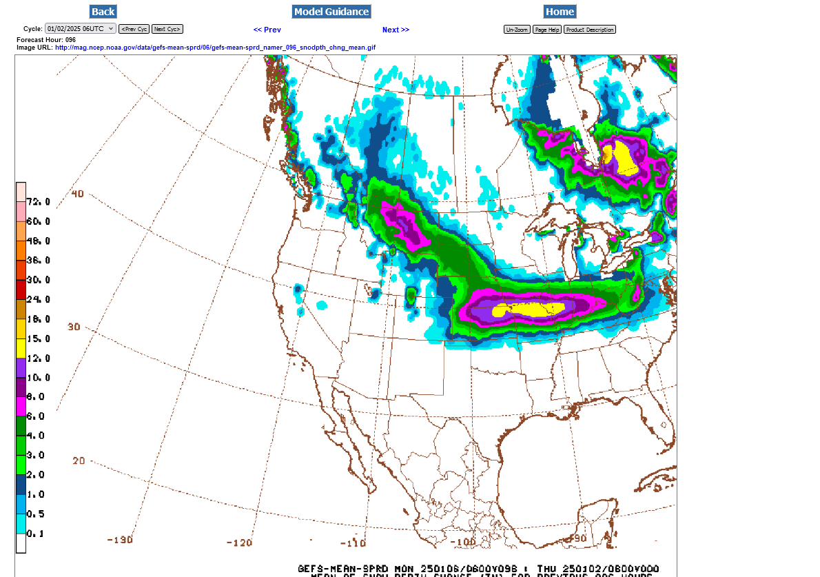
There could be alot of sleet for Evansville:
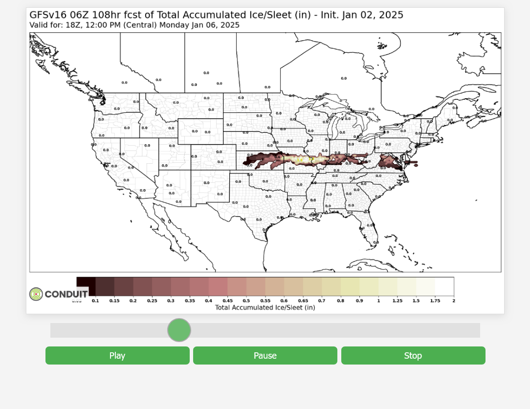
The just out 12z guidance has a bigger warm air intrusion, as the storm approaches.
As a result, I'm adjusting the forecast to PLAIN RAIN on Sunday Afternoon for numerous hours. This also shifts the heaviest frozen precipitation NORTH of Evansville.
We should still start with snow/sleet and end with snow but in between, when the heaviest precipitation is falling, it may be mostly plain rain.
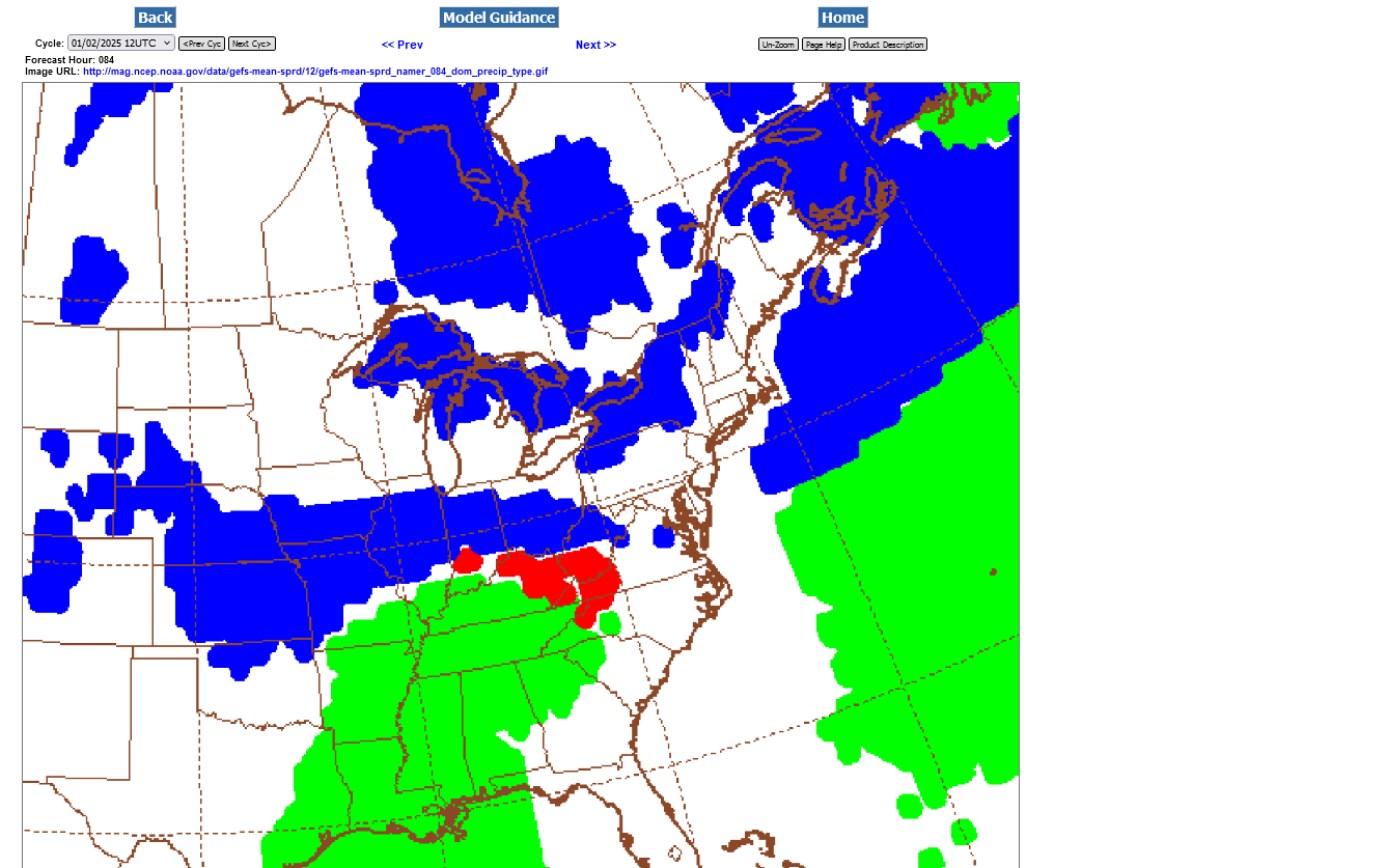
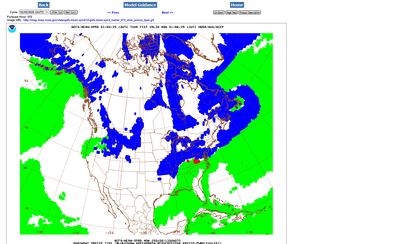
This is a good idea of where the NEW, UPDATED rain snow line will be on Sunday afternoon and evening. Green is LIQUID rain. Red is sleet/freezing rain. Blue is snow.
+++++++++++++
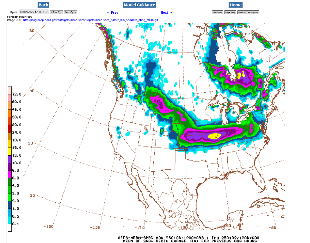
Here's what that same guidance has for total snow. Not much change from the forecasts above????
Doesn't look like it UNLESS you are right on the southern edge and it shifts north by 20 miles, because of air a few degrees warmer coming up with southerly winds around a mile up.
That's the difference between tons of snow and especially sleet at 31 degrees and plain liquid rain at 33 degrees.
+++++++++++++++
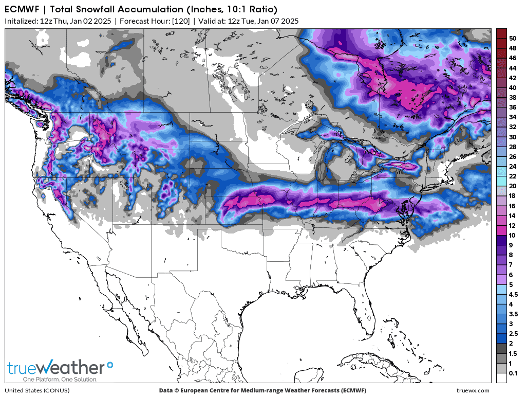
Last European model below:
+++++++++++++
This is what it means according to these latest updates(that could change). We will still be impacted by this major WInter Storm.
1. It will still start as snow, then quickly to sleet and freezing rain with some accumulations.
2. Then numerous hours of LIQUID rain that may wash off much of the frozen precip from the roads if its heavy enough.
3. Then, Sunday Night BACK TO ALL SNOW. Accumulations of several inches are still possible.
+++++++++++++
This last 12z European Ensemble average model(which has the best skill) has the same, slight northward shift and everything changing to rain Sunday afternoon, then back to snow Sunday night. However, this is not a done deal. Still some ensemble member solutions that have Evansville in the heavier frozen stuff for a longer period.
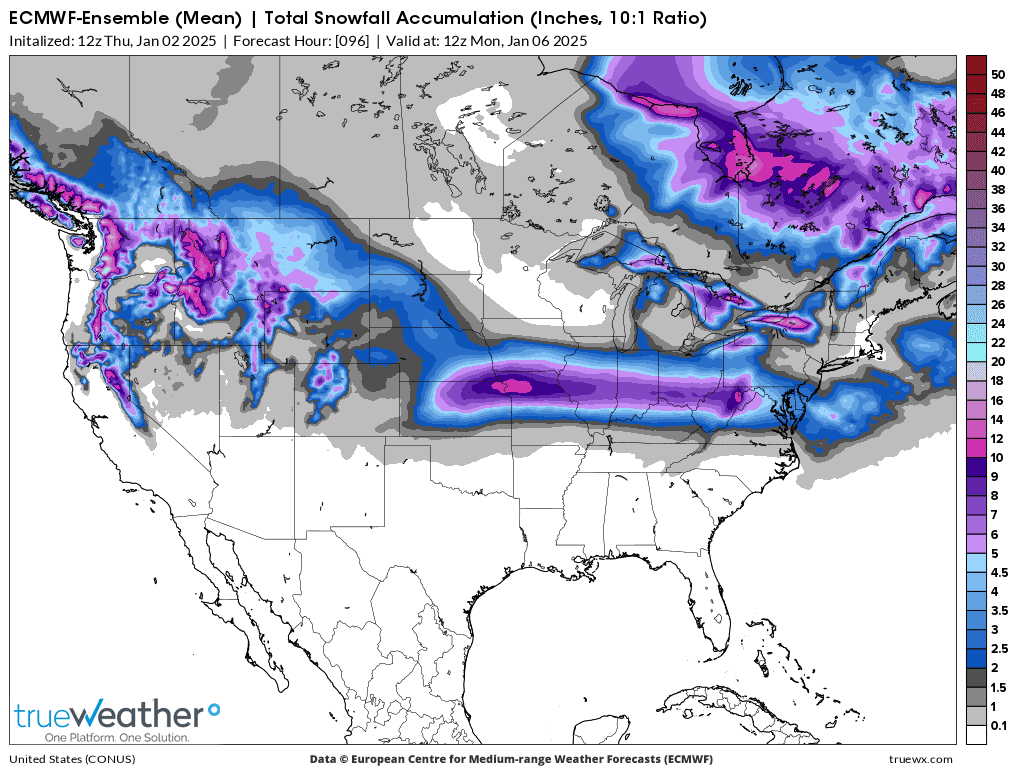
The NWS has issued widespread Winter Storm Watch's! We started this thread on December 30th, 3 days ago.
Go to the link below, Then you can hit any spot on the map, including where you live and it will go to that NWS with all the comprehensive local weather information for that/your county.

5pm, just out 18z GFS: Yellow=12 inches of snow
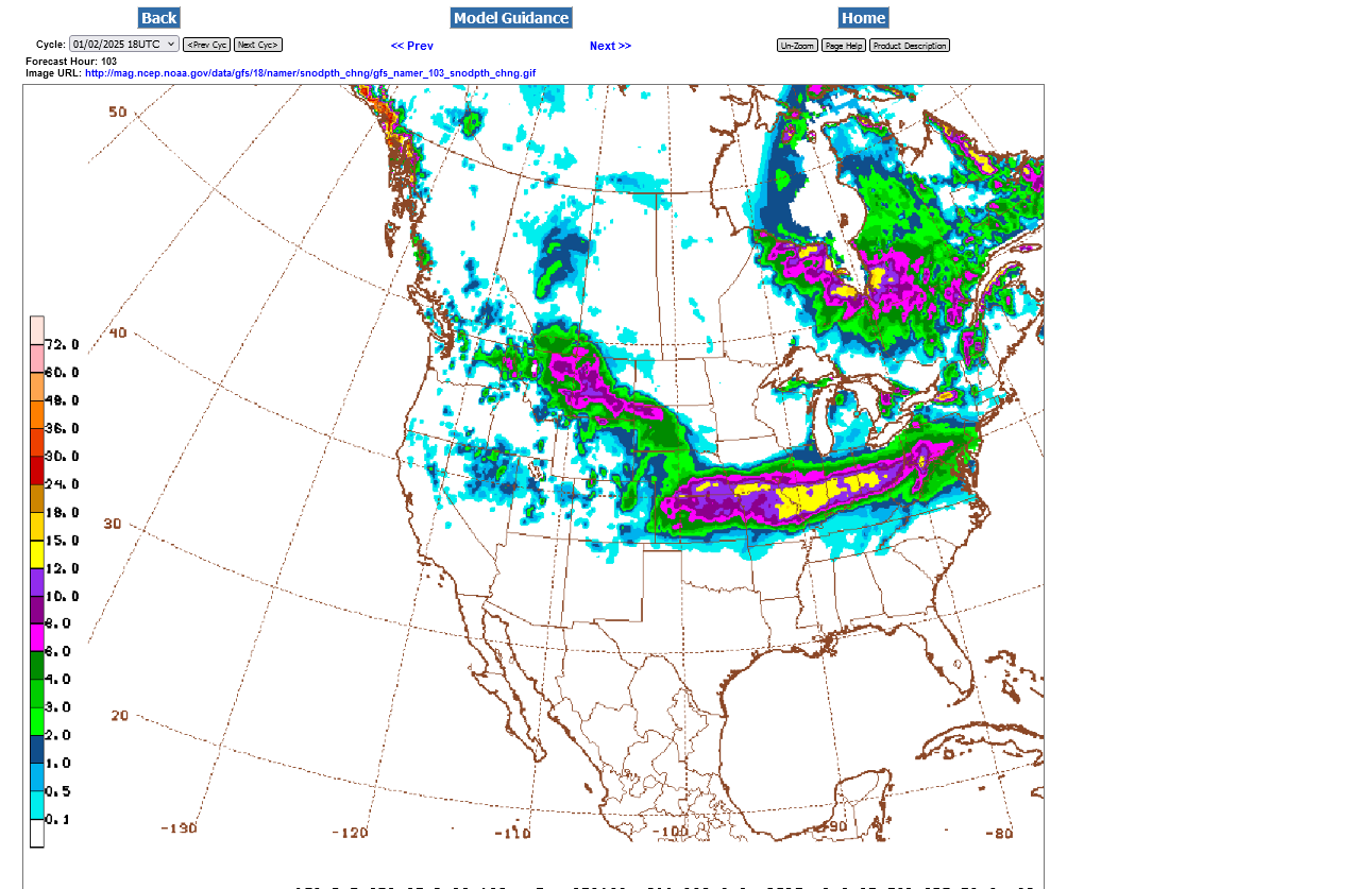
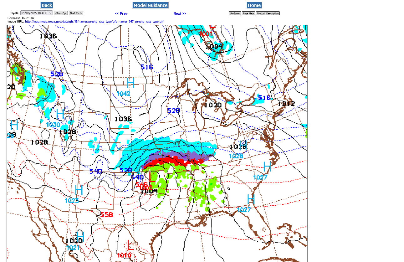
But Evansville goes to LIQUID RAIN for several hours after starting with snow/sleet/freezing rain, then changes back to snow at the end with a progression very similar to this below:
Snow at first?
Mixed frozen precip for awhile:
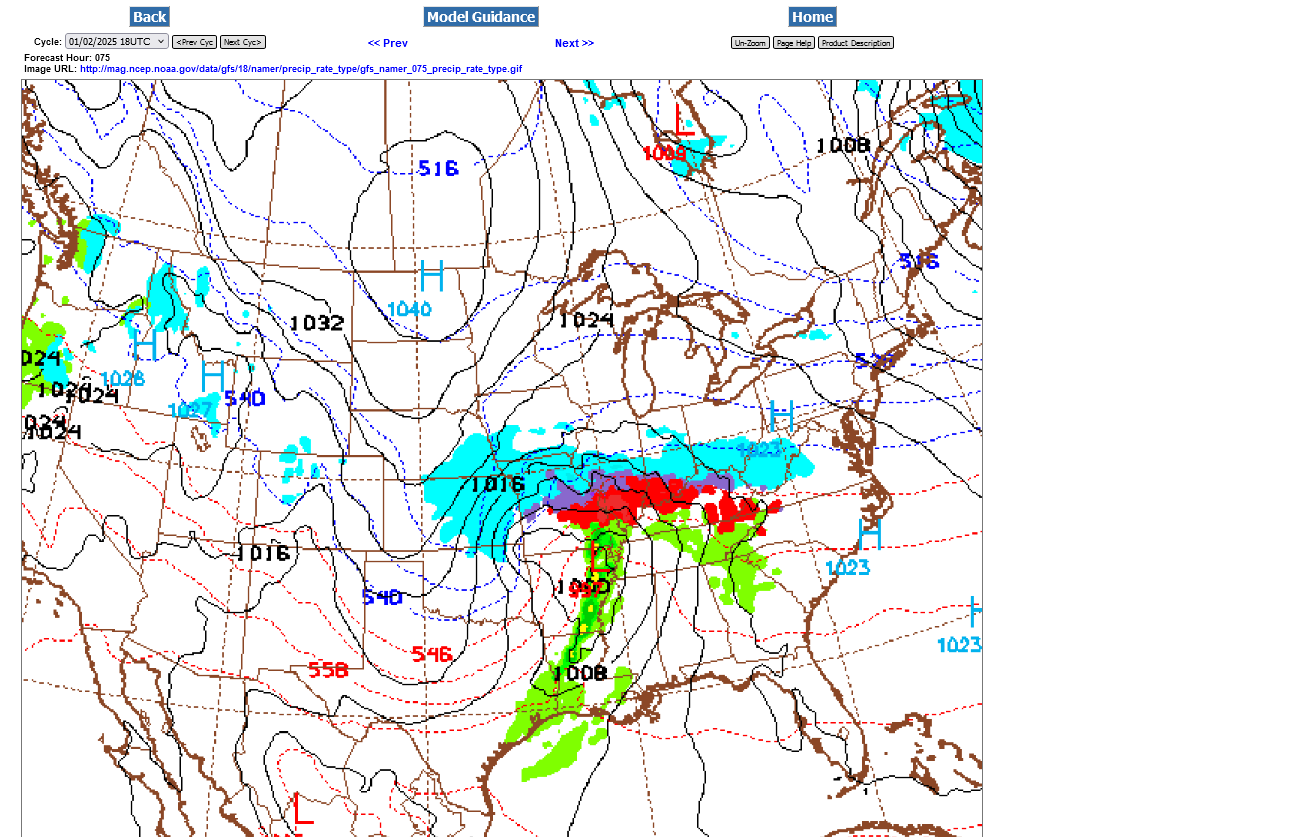
We're in liquid rain below on Sunday Afteroon: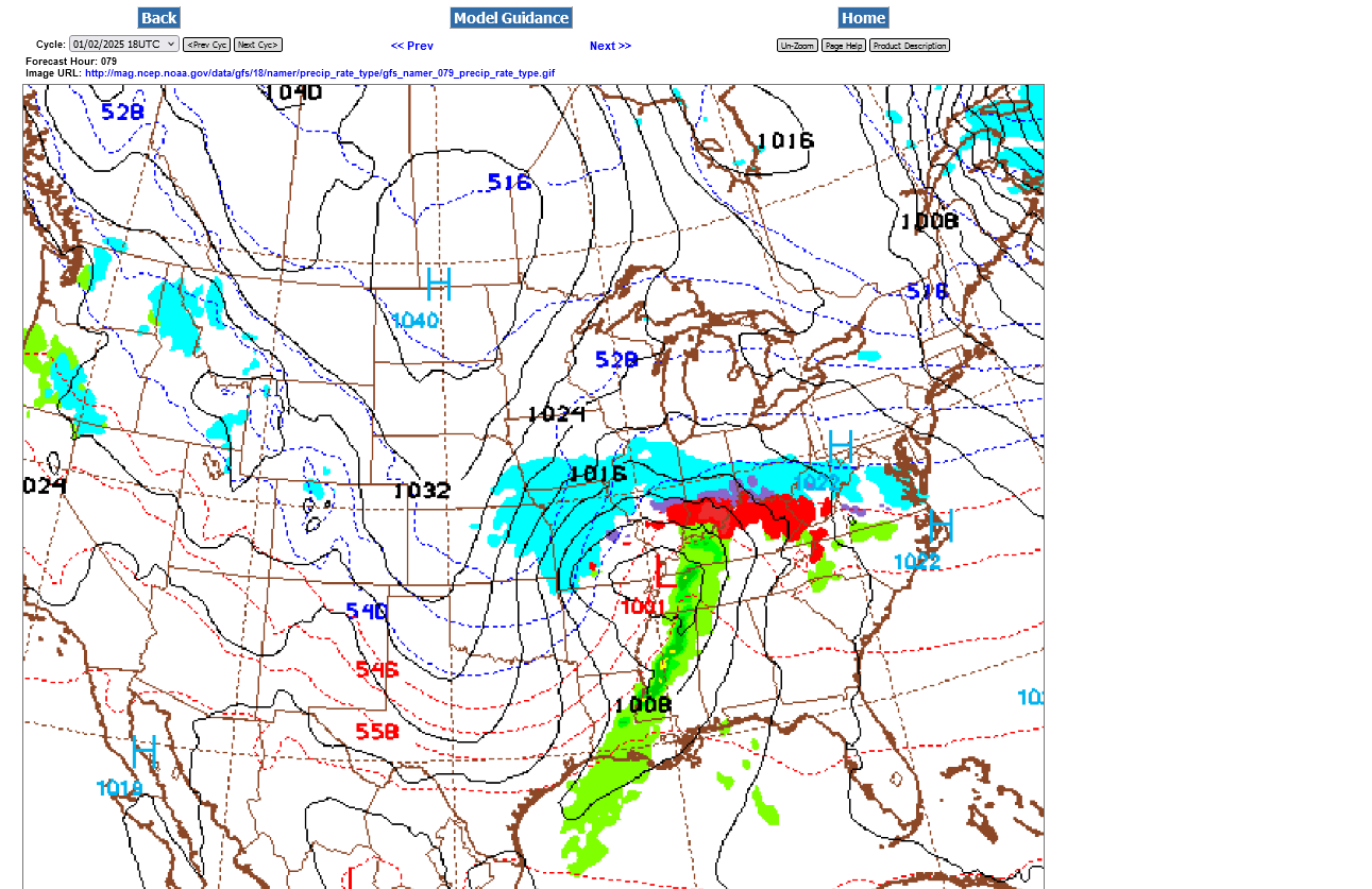
Back to snow very late Sunday/Sunday Night. Could be several inches still.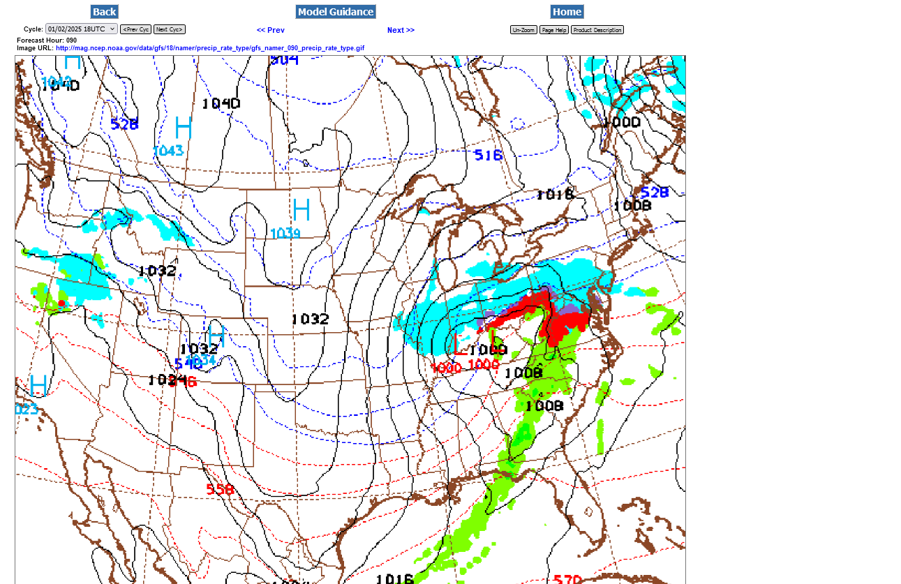
The last 0z model guidance has turned a tad colder again!
The early Thursday GEFS had turned a bit warmer. Suggesting liquid rain will spread north on Sunday with slightly milder, just above freezing air as a surge from the south, above the surface and just ahead of the storm.
The last 0z run, however has the colder air not being displaced as far to the north as the previous few runs, which had been trending warmer.
The European and Canadian models keep the colder air in place ahead of the storm as more tenacious and any changes to plain rain would be brief, with freezing rain and sleet possibly continuing Sunday Afternoon, instead of liquid rain as the GEFS has. We are also closer to the heaviest snow, which will be occurring BEFORE we change over, to sleet then freezing rain as some warmer air works in aloft, then back to snow again when cold wins the battle on the backside of the storm.
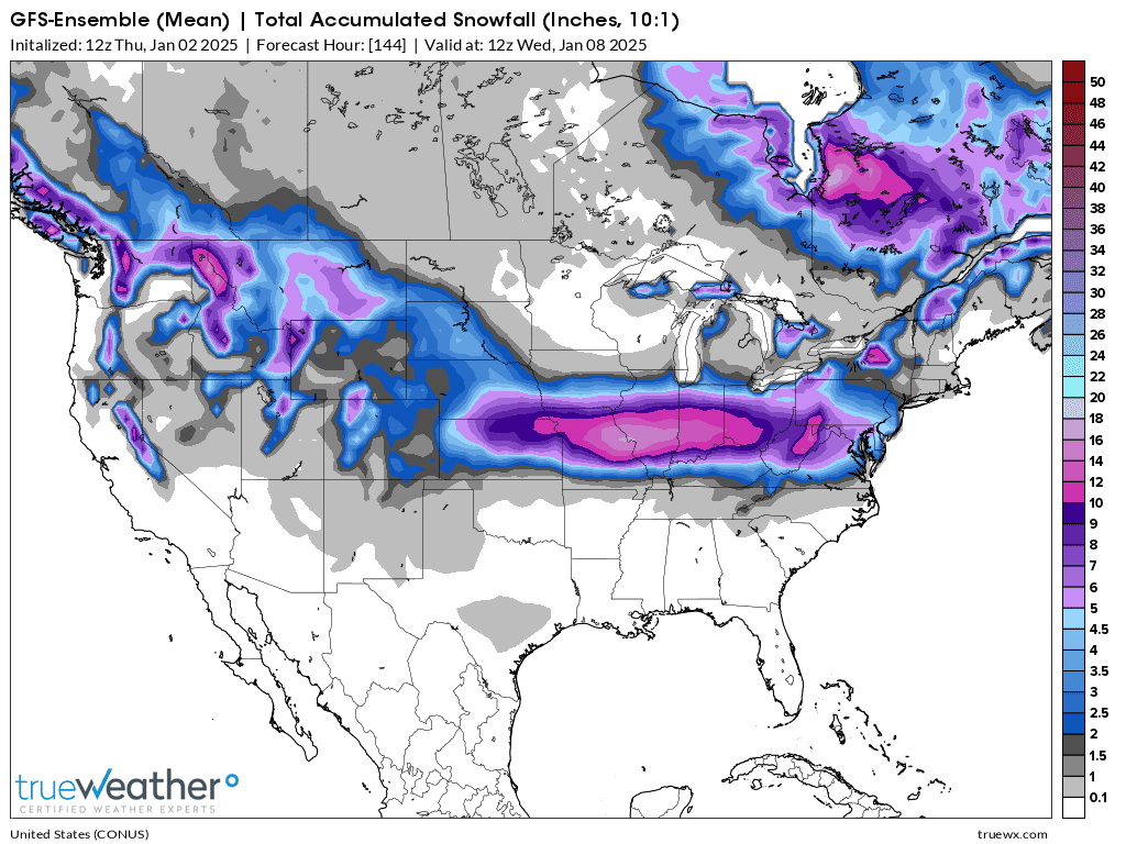
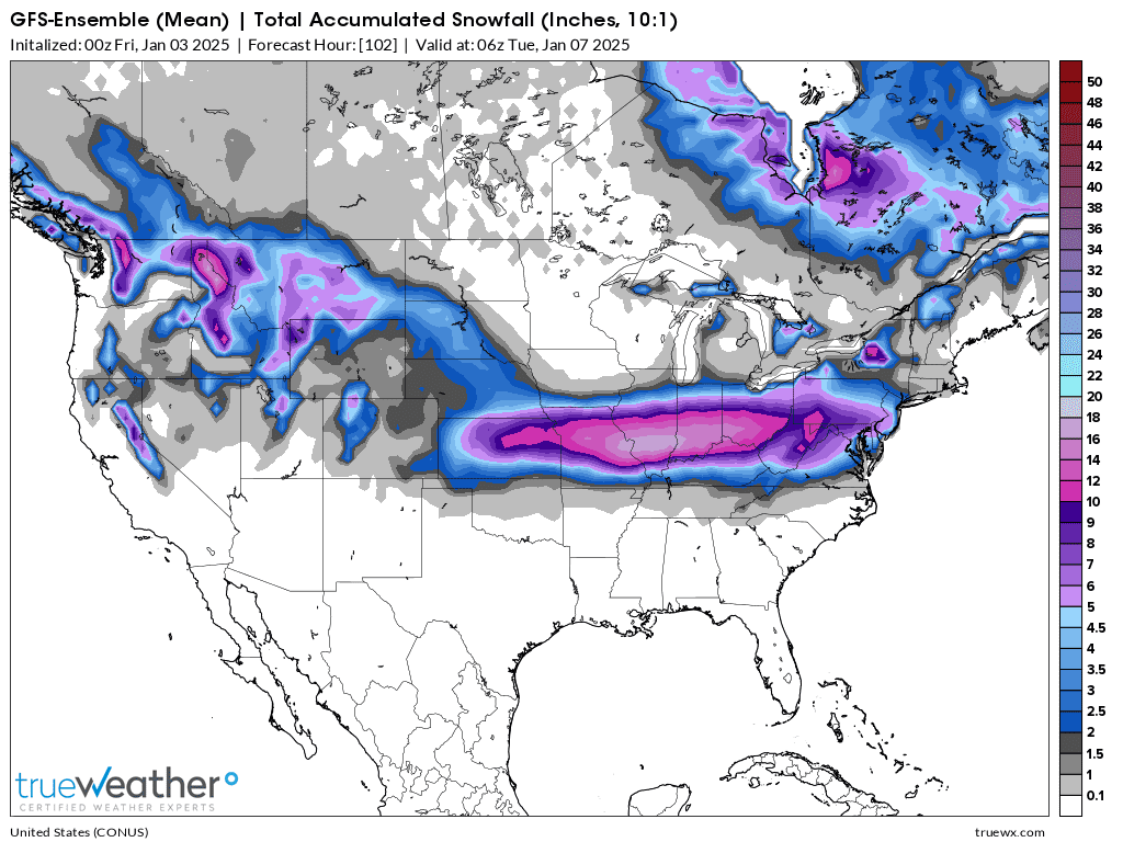
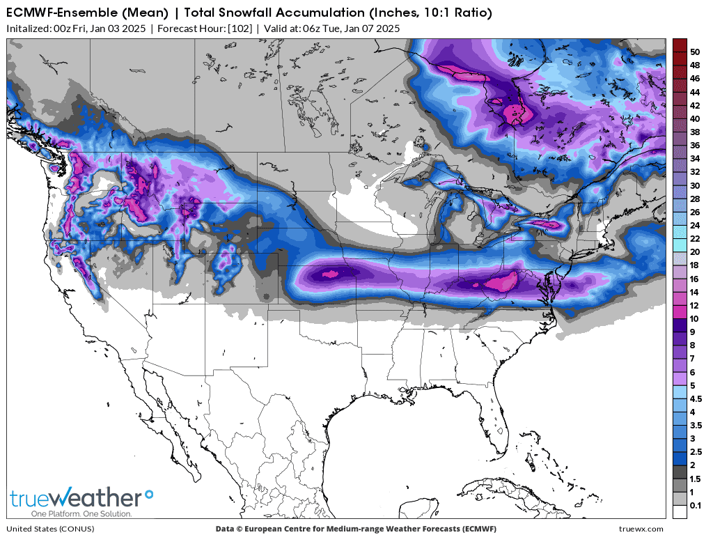
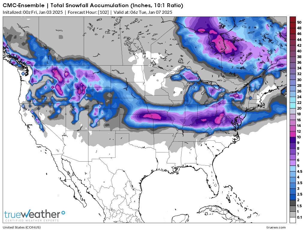
Comparison of recent runs of the GEFS(American model). We are right on the edge of the heavy frozen stuff.
1. (old model)12z GEFS-2nd Hard to see but the dark purple= 8 inches is just NORTH of Evansville.
2. Latest 0z GEFS-3rd That same purple is maybe 25 miles farther south down to the Ohio River in Southwest Indiana.
3. 0z European Ensemble-not that much different
4. 0z Canadian-close to the same too.
OH, OH!!!
The GEFS(American model) is run every 6 hours.
This last 6z run was THE COLDEST YET, after the run 18 hours prior(12z run Thursday) shifted milder and changed the frozen precip to liquid rain on Sunday afternoon.
We will still see some changes but are getting close enough so that changes now, COUNT THE MOST!
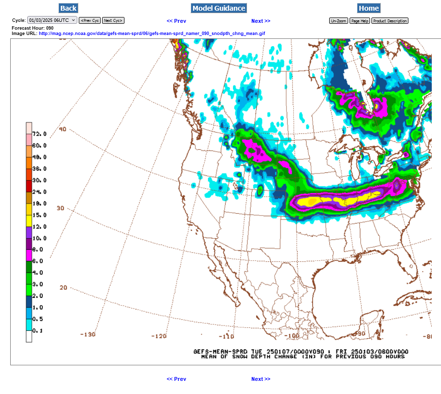
Let's use a different weather provider that depicts total snow amounts with more vivid coloring to demonstrate what just happened.
1. Late Morning Thursday solution-light green along the Ohio River= 2+ inches of snow
2. Very early Morning Friday solution-darkest purple along the Ohio River = 8+ inches of snow!
Some to much of this will likely fall as sleet and freezing rain!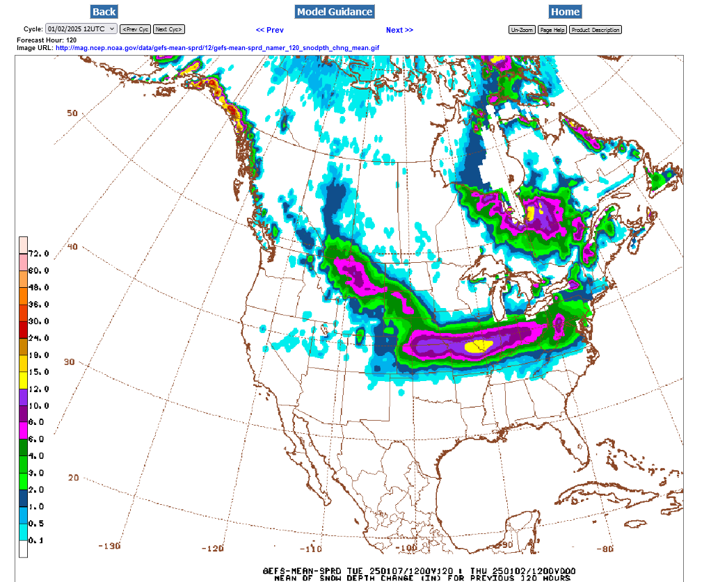
++++++++++++++
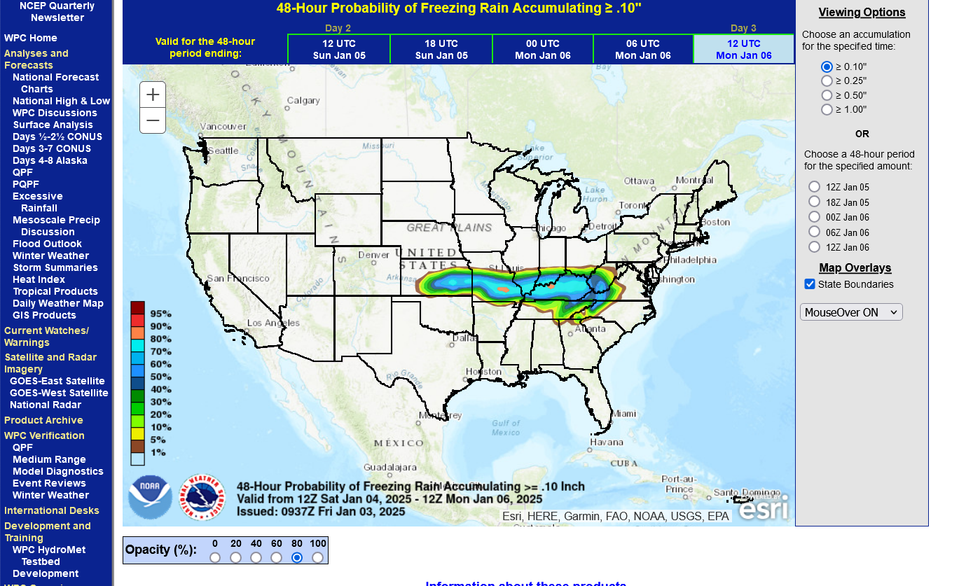
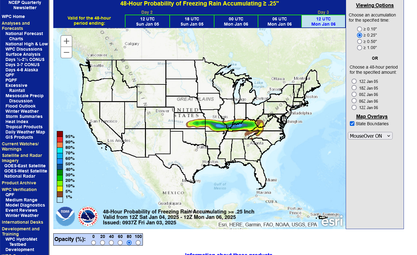
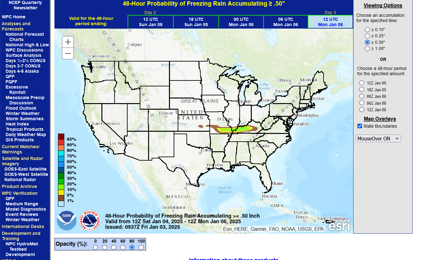
We're close enough now to use a great product from the NWS that depicts freezing rain chances/amounts(that we already knew was going to happen).
https://www.wpc.ncep.noaa.gov/pwpf/wwd_accum_probs.php?ftype=probabilities&fpd=48&ptype=icez
1. Chance of 1/10th of an inch =.1 inches=75%
2. Chance of 1 quarter of an inch =.25 inches= 40%
3. Chance of 1 half of an inch =.50 inches= MOST LIKELY JUST SOUTH OF US-but it's close.
Keep in mind that the latest guidance, being colder has shifted the freezing rain farther south and added sleet and snow accumulations.
The NWS will be issuing Winter Storm WARNINGS later today.
The just out 12z guidance is just a tad milder again but NOT as mild as 24 hours ago. There is a 100% chance that this will be a VERY MAJOR WINTER STORM in Evansville, possibly historical.
Here's the latest depiction for type of precipitation from this just out model. The top map tells us why its going to be so BAD. Regardless what falls, there will be a lot of it. The light blue is over 2 inches of liquid equivalent. If that was all snow, it would be over a foot. It won't be all snow because some will be sleet and some will be freezing rain. It really is impossible to know right now because a 1 deg. difference in the vertical temperature profile makes a huge difference with us being just south of an all snow profile. Some could still be rain but the cold sub freezing air near the surface will be hard to dislodge with the center of the surface low to our south.
Total liquid precip 2"+. We are in the center for GREATEST AMOUNTS. The heaviest (highest accumulation rates) will be from mid morning Sunday until around Midnight Sunday. This is MORE than previous model runs.
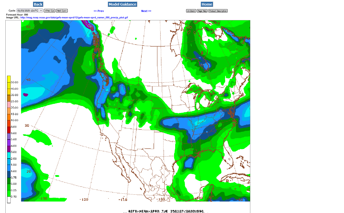
Sunday BEFORE 6 am = light snow
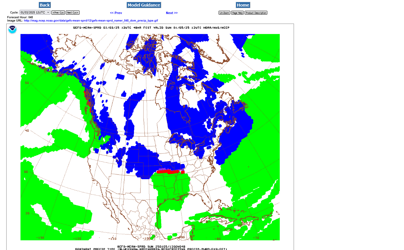 +++++++++
Before Sunday Noon: Changing to sleet/freezing rain-HEAVY rate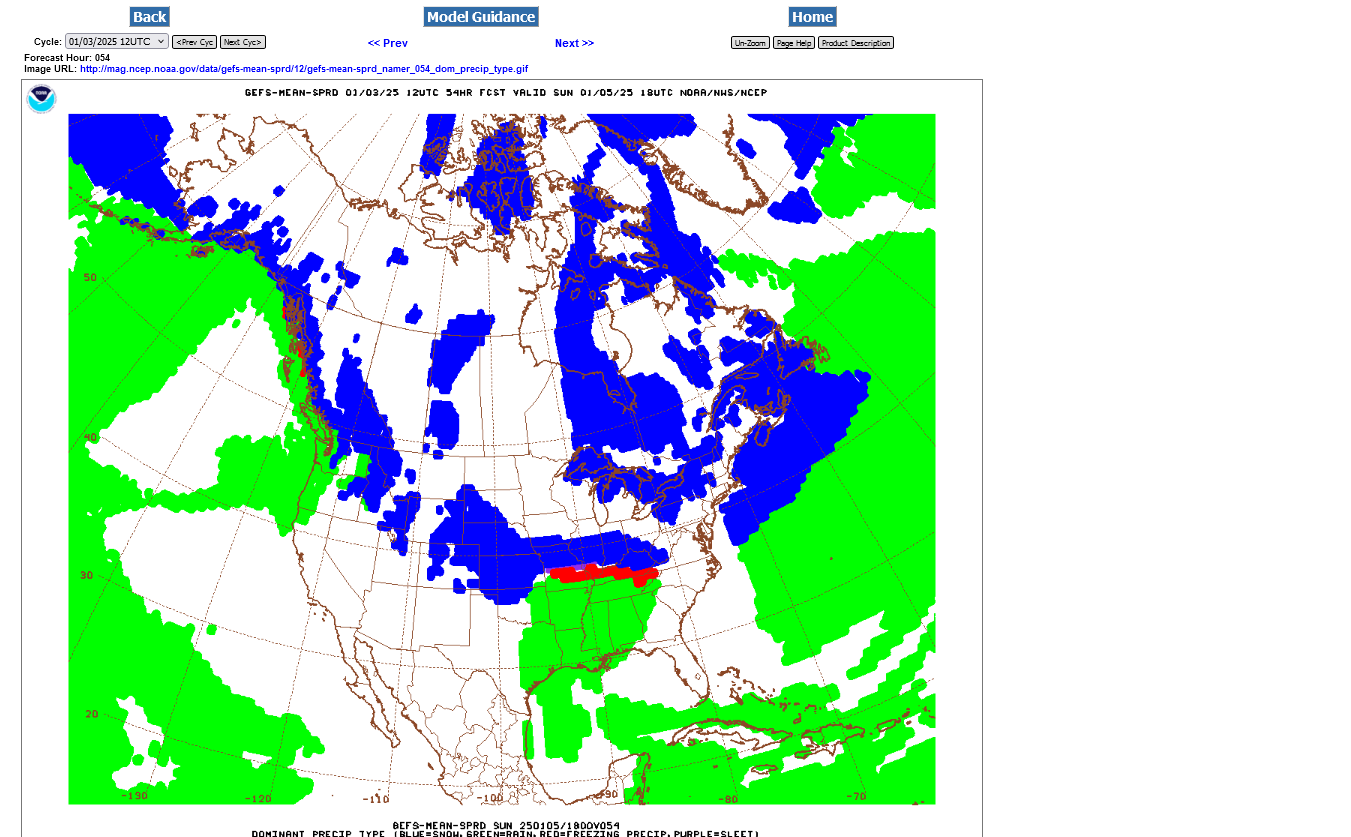
++++++++++++++
Sunday 6pm: All freezing rain. Maybe sleet mixed in. Only chance of snow is if the models are all too warm-HEAVY intensity. Only chance for liquid rain is if the models are all too cold at the surface.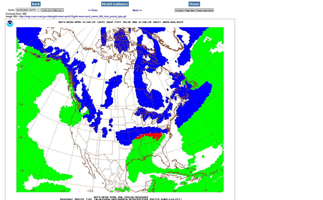 ++++++++++++++
Sunday Midnight: Freezing rain changing back to sleet then snow-intensity diminishing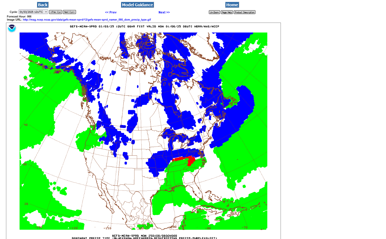
Monday 6am: All snow for sure: Light intensity
+++++++++
Below is the last snow forecast. The heaviest snows of 12"+ in yellow will be very likely to the NORTH of Evansville. This is a slight shift northward from the previous run 6 hours ago but COLDER/SNOWIER than the one on Thursday morning that gave us some hope for more liquid rain. It's likely that more than half of our frozen precip will be sleet/freezing rain but a tiny shift can alter that a great deal.
Tuesday thru Saturday: Bitter Cold, subfreezing during the day, near 0 late in the week for lows:
https://www.marketforum.com/forum/topic/83844/#83851
So it will be tough to melt after it falls!
I guess i better go drag my snowblower out of my shed.
Looks like you'll be all snow, Jim! I'll trade ya
The NWS in Paducah, decided to NOT issue any warnings yet because of the uncertainty of temperatures and precipitation types to delineate exactly what warnings to put in what areas. They are convinced it will be bad in our area but, especially in Western KY, where do they issue an ice storm warning, winter storm warning or travelers advisory?
We will probably have a Winter Storm Warning but COULD have an ice storm warning. Near 0% chance for anything less serious than that.
The GEFS model continues to be warmer than the Canadian and European models, enough to make a difference of 25 miles north or south, which is HUGE in a situation like this.
This just updated 18z GEFS got a smidgen warmer again, enough to shift everything north by 10 miles or so.
A reason for why this might not be nearly as bad as what we think in the areas with the heaviest freezing rain is this. The high intensity of freezing rain falling on Sunday Afternoon, with the temperature just below freezing will make it difficult for the rain to freeze on most elevated objects!!!
Instead, what we are likely to see during the heaviest freezing rain, with a temperature of, lets say 30 degrees is the rain NOT being able to stick to tree limbs and power lines, the way that light freezing rain and drizzle does. Instead it will just turn into runoff on the ground and melt/wash out some of the sleet/snow that fell earlier. Some of it will just be absorbed by snow/sleet on the ground that doesn't get washed, then will refreeze in those areas on Sunday Night but NOT on the elevated surfaces.
It all depends on the intensity of rain and temperature. Brisk winds during this event will increase the chance of problems with elevated objects that do collect ice.
Our historic ice storm in 2009 featured a pattern MUCH DIFFERENT than the current one.
1. Temperatures were well down into the 20's,(10 degrees below freezing) with a very shallow layer of cold at the surface and northerly winds.
2. Temperatures aloft were ABOVE freezing above that shallow layer, so it rained but the rain didn't have enough time to freeze into sleet before hitting the ground, so it froze on the surface. In 95%+ of similar situations, when the air temperature is that cold, in the low 20's you will get sleet, which doesn't stick on trees and power lines. In fact, its more slippery than snow. Big sleet storms feature piles of sleet on the ground surrounding houses because it all slides off the shingles, instead of sticking.
https://www.weather.gov/media/pah/Top10Events/2009/Ice%20Storm%20Jan%2026-28%202009.pdf
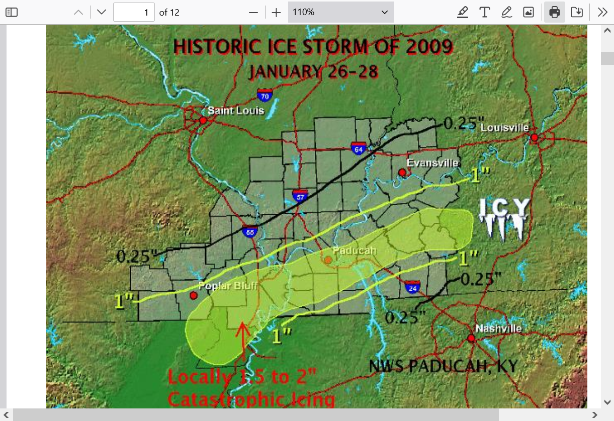
We went Florida on Spring Break in March of 2009. So sad to see most of the trees on both sides of the highway, traveling thru Western Kentucky with no branches left. Like many thousands of giant tooth picks in the ground. All of them destroyed/de-branched by the ice storm 2 months earlier.
++++++++++++++++++++++++
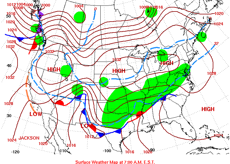
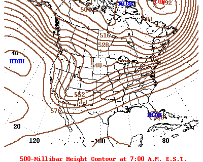
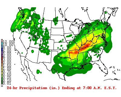
These were the weather maps for that ice storm:
| ||
| PREVIOUS DAY | TUESDAY JANUARY 27, 2009 NEXT DAY | |
1. Huge Arctic high pressure to our north feeding in frigid air at the surface
2. Temperatures in the 20's- 10 degrees below freezing.
3. Very long lasting Southwest flow aloft bringing in milder air with a large scale upper level trough/storm in the Rockies that took a couple of days to pass by after the precip started. The humid/milder air aloft ran over the cold air at the surface as the the liquid H2O condensed out and remained liquid until hitting the cold surface.
4. HEAVY amounts. The surfaces were already very cold to start with and with the temp WAY below freezing, even moderate intensity freezing rain was able to stick. And it went on for more than 1 day.
5. Precip on the 2nd day of the event
https://www.wpc.ncep.noaa.gov/dailywxmap/index_20090127.html
Surface map
Surface temps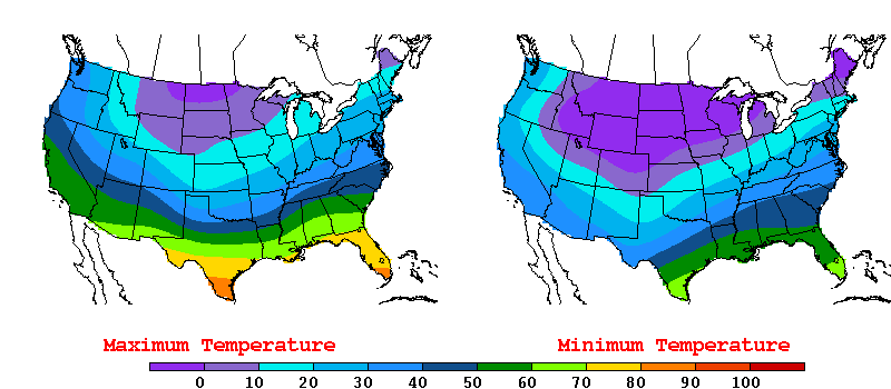
Upper levels
 Precip day 1
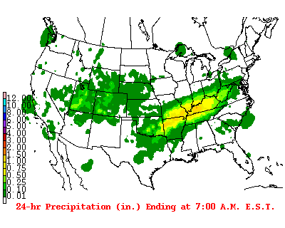
Day 2 precip:
+++++++++++++++++
What's different this time? January 5, 2025?
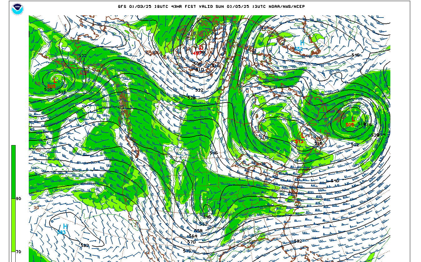
1. The upper level low to our west is potent but compact. The amount of precip it will generate with the southwest flow as it approaches will be higher intensity at times but not last nearly as long as 2009. Heavy freezing rain at 30 degrees is not going to be able to stick and freeze to surfaces, like light freezing rain or drizzle.
2. There is no Arctic surface high to our north/northeast like in January 2009. This is what fed a continuous flow of very cold air, deeply south and hugged the ground with temps 10 degrees below freezing at the ground, when 1 mile up, temps were ABOVE freezing in 2009 from southwesterly winds. The Arctic blast this time will come AFTER this system passes, not before it. Temps this time are close enough to freezing that it will be tough to freeze the rain, especially if its heavy.
Sunday upper level 500 mb map
Sunday morning surface map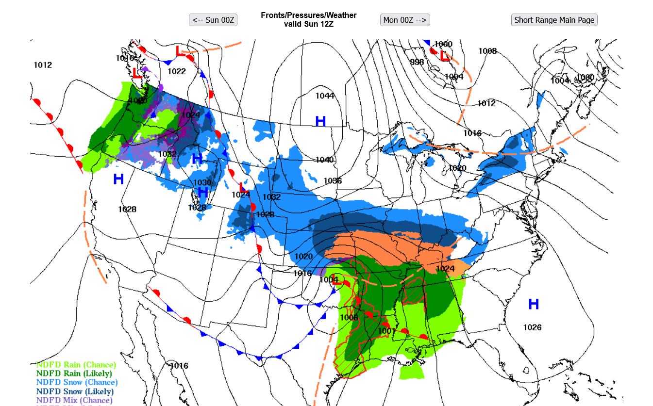
The local Paducah NWS finally decided on where to delineate it's warnings/advisories just after 5am this morning.
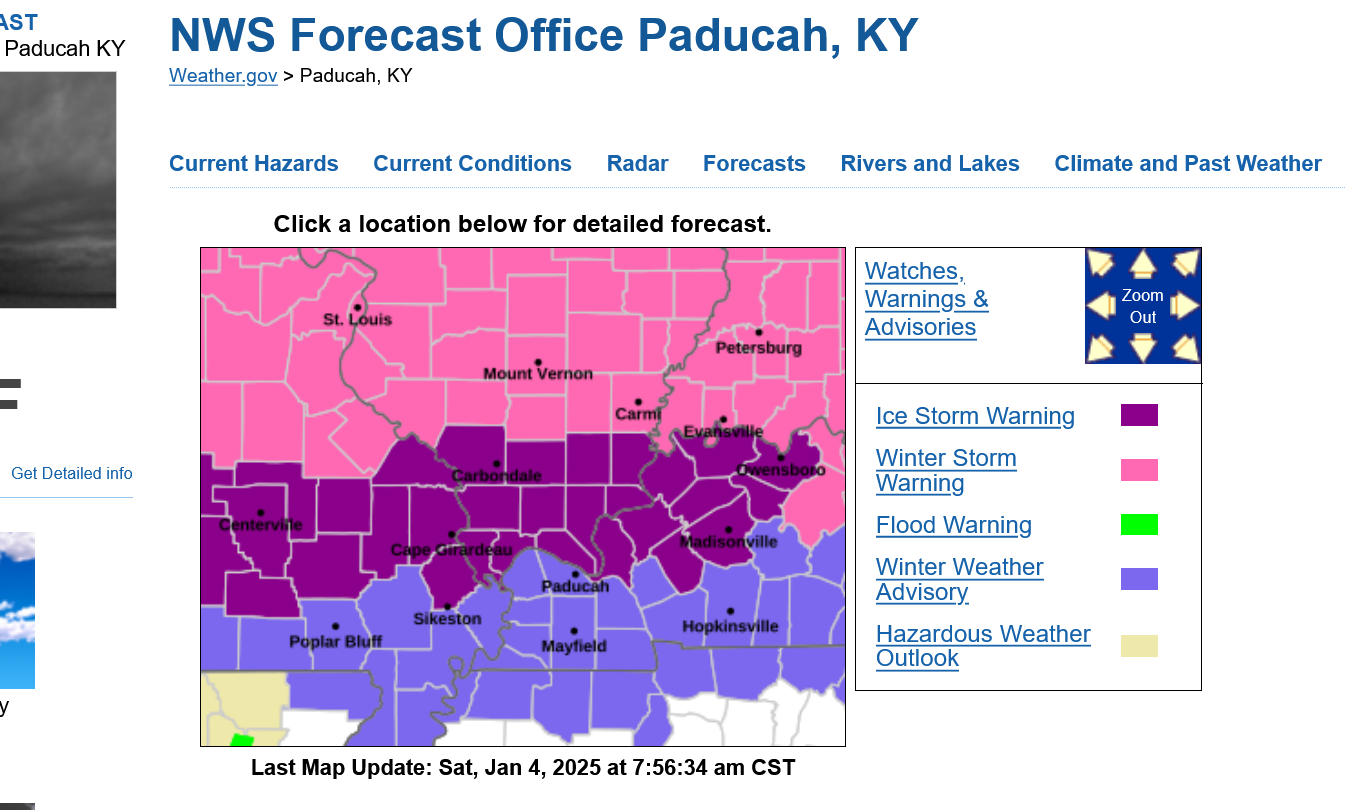
This was their latest technical discussion:
Area Forecast Discussion
National Weather Service Paducah KY 535 AM CST Sat Jan 4 2025
I would draw these maps a bit differently but they give you a general idea of what to expect the next 2 days:
Midnight Saturday: Light snow getting close. Starting well before dawn:
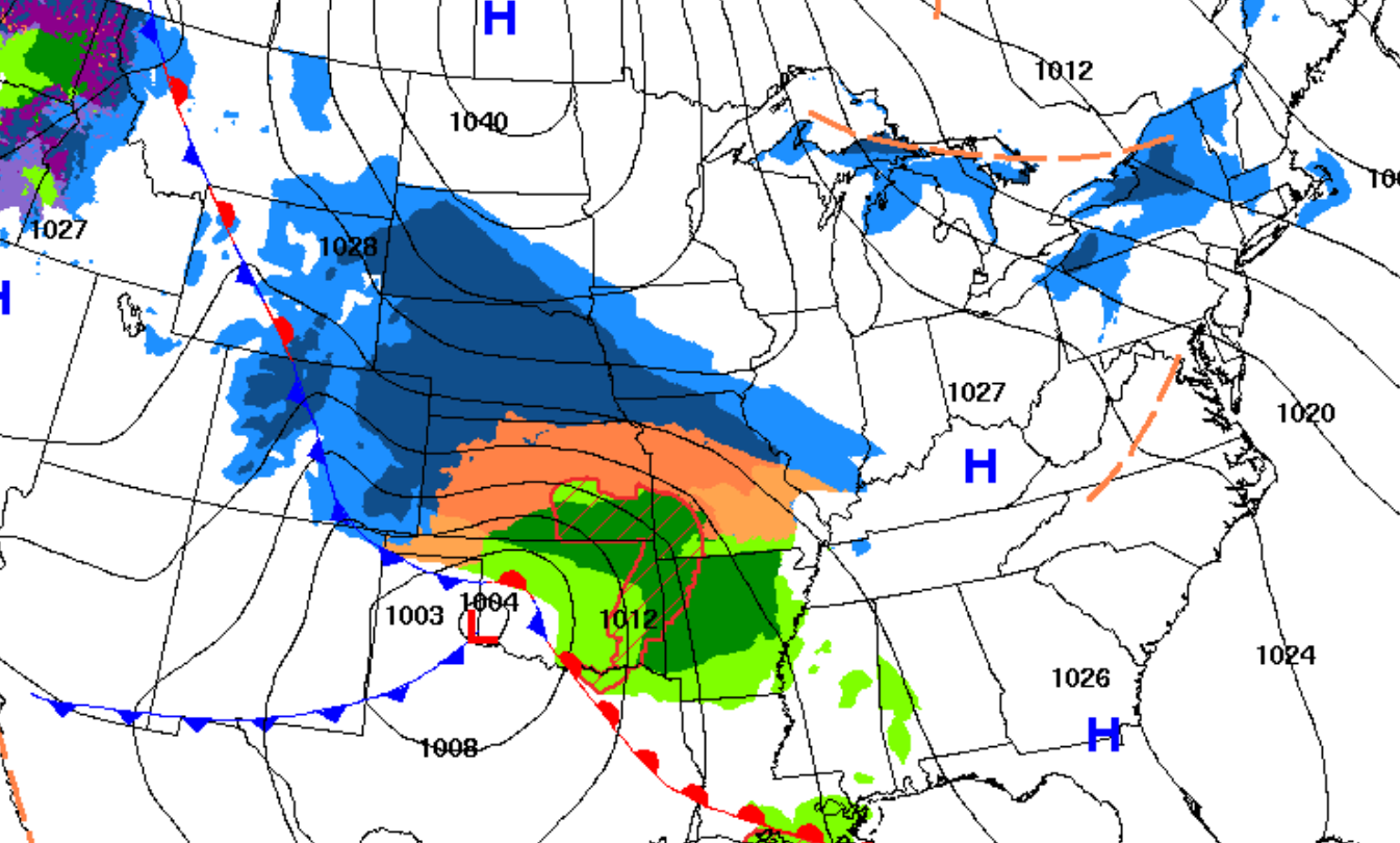
++++++++++++++++++++++++
6am Sunday: Heavy snow early in the morning, mixed with or change to heavy sleet(several inches of snow/sleet?), then freezing rain(mixed with sleet), starting after 1pm? Heavy intensity!!! Winds increasing on Sunday, gusting to 30 mph.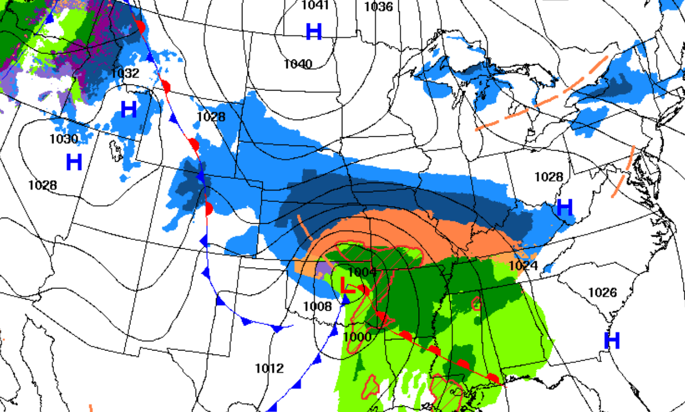
+++++++++++++++++
6pm Sunday: Continuation of freezing rain/mixed with sleet. Windy(gusts to 30 mph). Heavy intensity, ending around midnight? with a dry wedge spreading across the area. This map does NOT show that. Just light snow after midnight.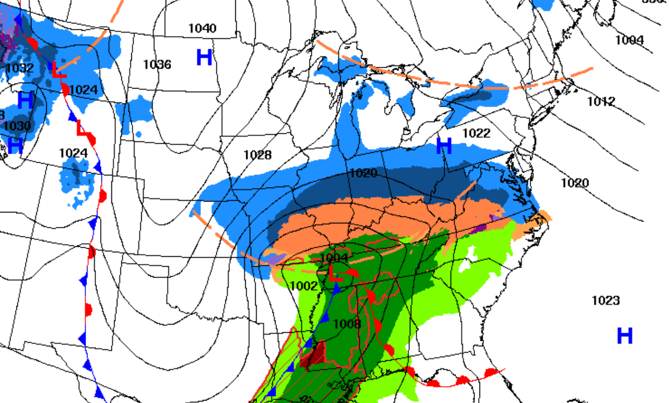
++++++++++++++++++++++++
Monday 6am: ALL SNOW returns on the backside of the storm early Monday morning. A couple inches likely EARLY Monday. Windy, gusting to 30 mph. Snow ends before noon. Winds diminish LATE Monday.
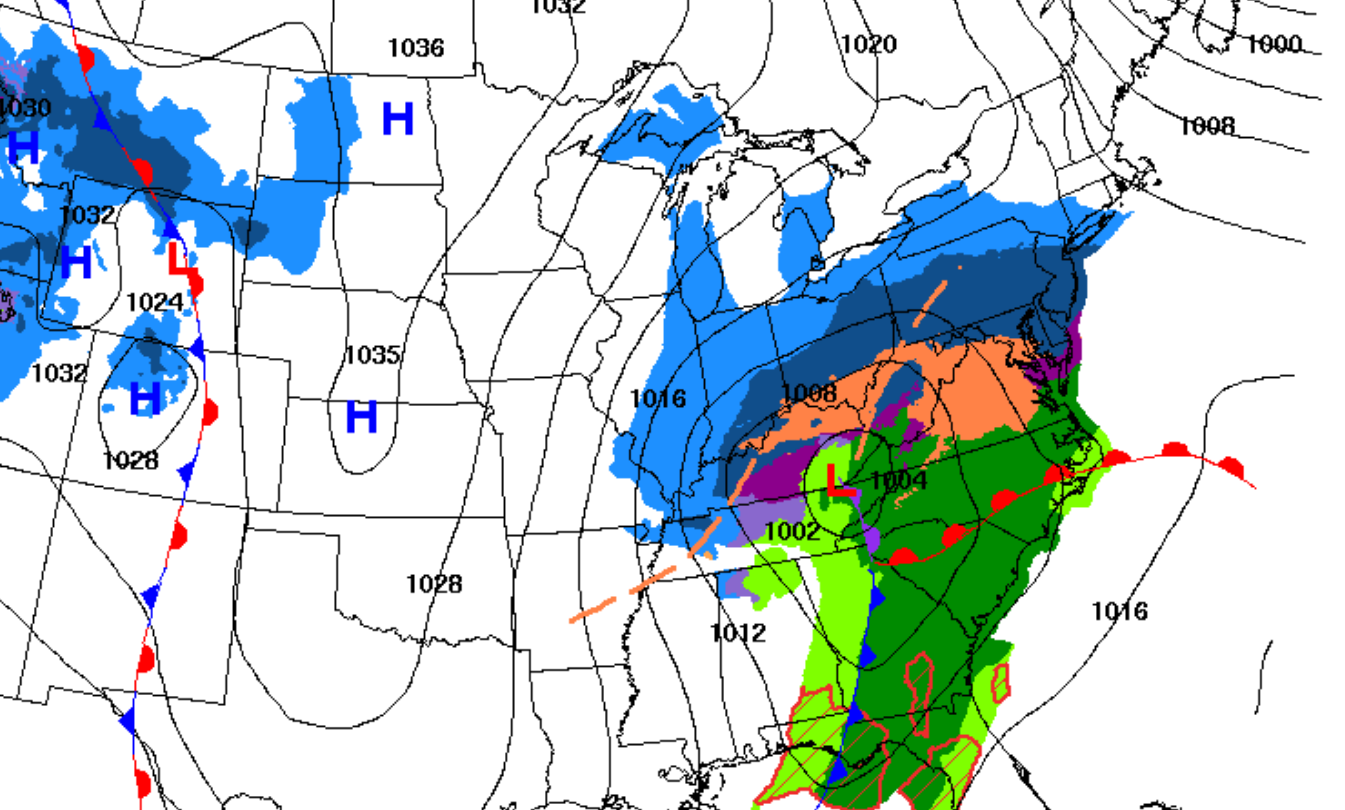
+++++++++++
Hourly weather graph:
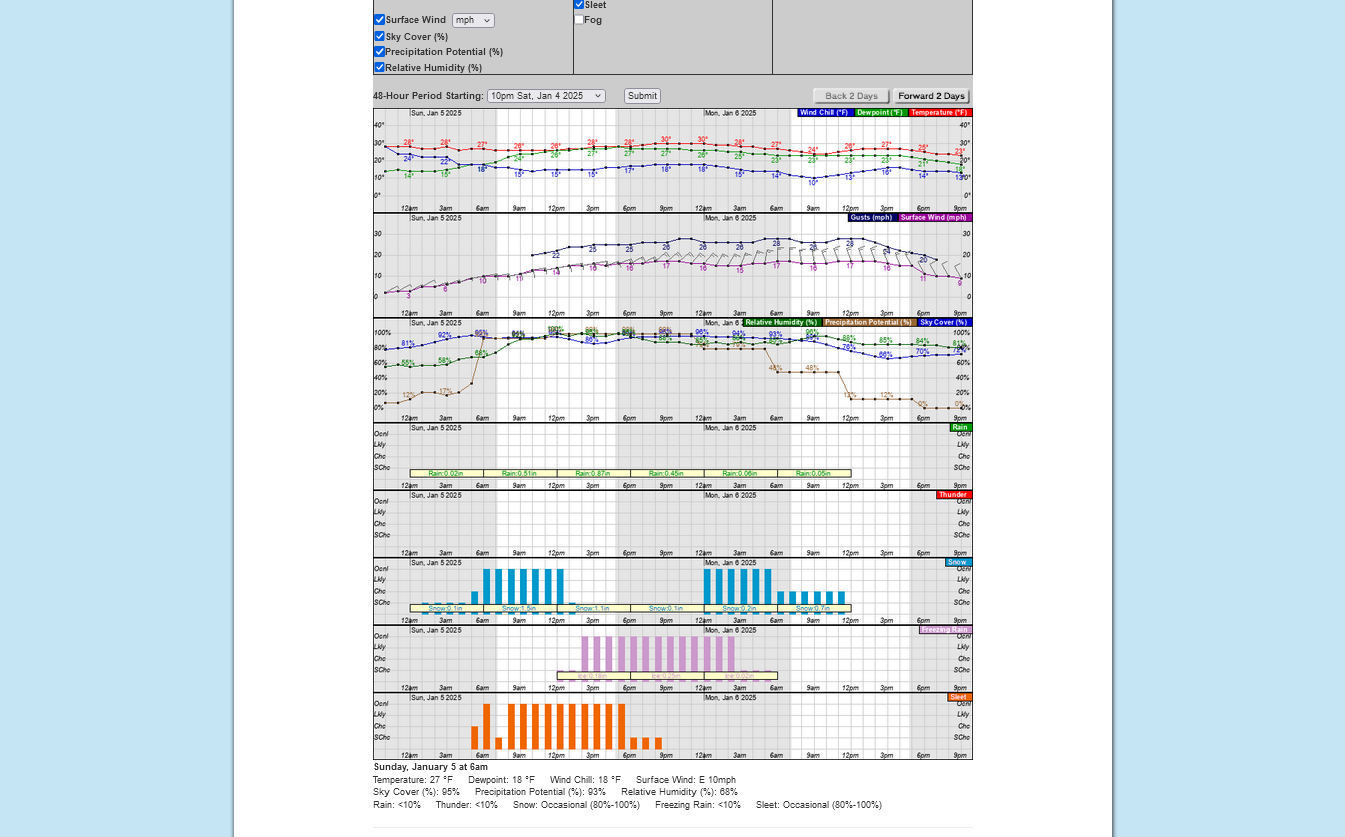
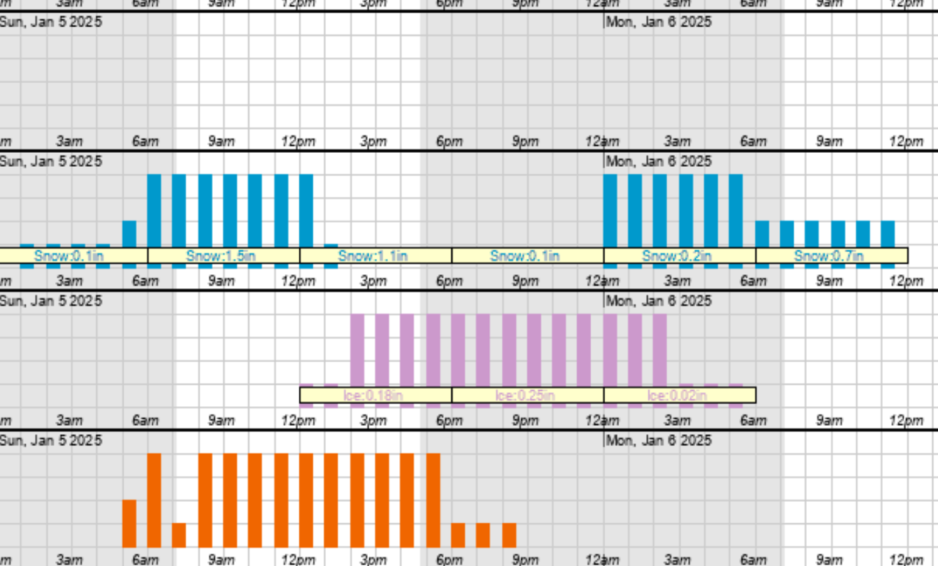
Orange is sleet/ice pellets(rain freezing BEFORE hitting the ground).
Pink is freezing rain (rain freezing after it hits the ground).
1. Snow starts first when all layers of the atmosphere are ABOVE freezing.
2. Sleet starts when a warmer layer aloft turns the snow to rain but the cold air near the surface is deep enough to freeze the rain before hitting the ground.
3. When the depth of the shallow cold air hugging the surface erodes and temps at the surface are still below freezing, THEN freezing rain happens.
4. Only if the surface temp climbs above 32 degrees does it become liquid/plain rain. Stiff northeast winds will be feeding in enough cold air near the surface to suppress temperatures during the entire event.
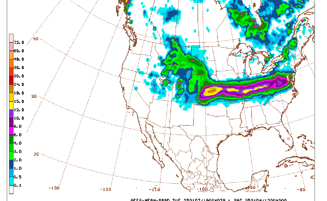
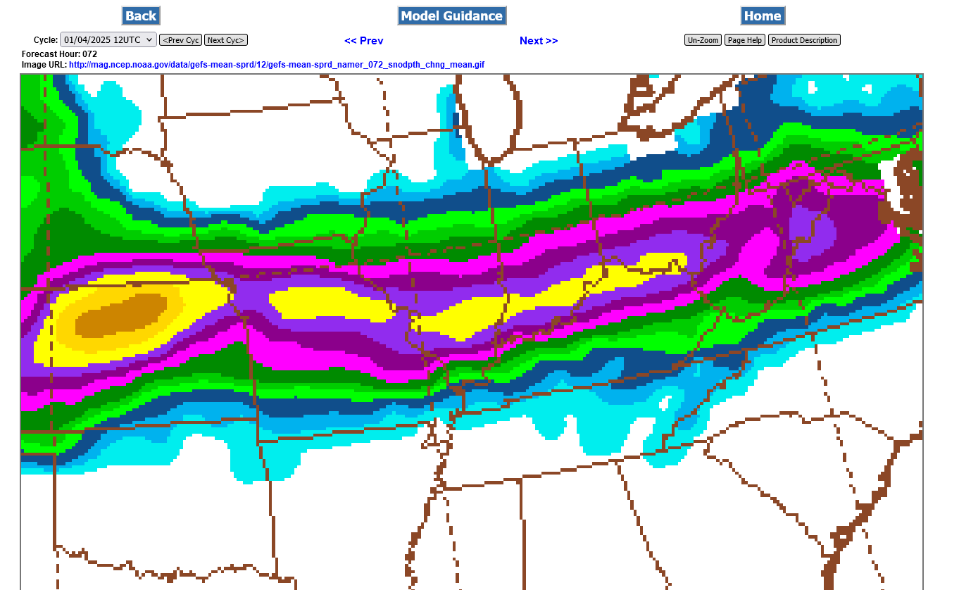
This was the total snow from the last 12z GEFS. The dark red along the Ohio River is 8+". Not a great deal different from recent runs. I think some of this snow is going to come out, instead as freezing rain that will also melt and compact the snow that fell earlier.
HEAVY freezing rain at just below freezing will actually not be able to freeze as effectively as LIGHT freezing rain/drizzle. This may reduce how much is able to collect on exposed, elevated surfaces.
If the temperature stays in the 20's/a couple of degrees colder than forecast on Sunday, that will make a big difference in how much freezing rain is able to stick. However, rain falling from the warm layer aloft could actually warm the surface close to freezing.
++++++++++++++
https://www.weather.gov/iwx/sleetvsfreezingrain
https://www.headspace.com/articles/mid-winter-blues
R.E.M. - It's The End Of The World As We Know It (And I Feel Fine) Lyrics
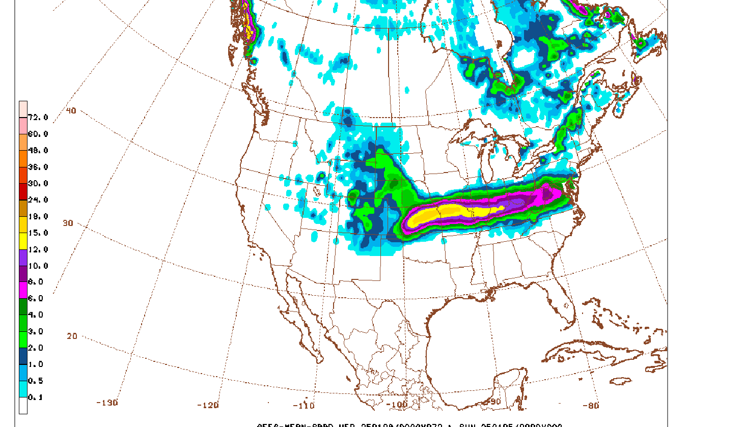
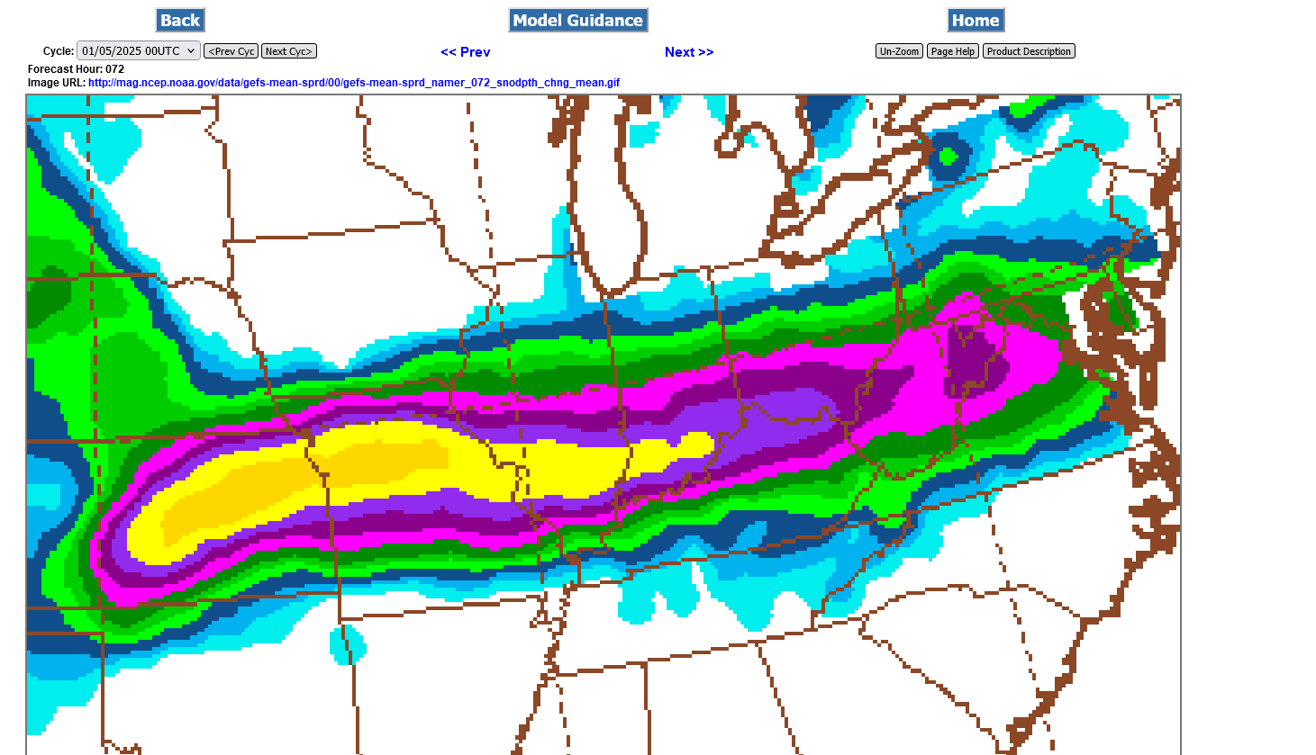
This was from the just out, 0z GEFS (American) ensemble model. A tad colder and a slight shift south with heavier snow totals for Evansville. Close to 10 inches if you believe this. However, freezing rain in the afternoon, heavy at times may cut back on that amount. If, however the models are too warm .......even by a couple of degrees, then we WON'T have a lengthy period of freezing rain and the snow could reach a foot.
++++++++++++++++++
Update at 6am: Despite the reality of it being just a tad warmer than models this morning this just out 6z GEFS, below is not backing down on the forecast for snow amounts. Current and future forecasts are not going to be comparable anymore because of the NEW snow already fallen will no longer be part of our updated forecasts. It was still predicted snow in the earlier forecasts.
In fact, this last model forecast, just 30 miles northwest of Evansville, has a small 15+ inches snow band in darker yellow. At this point, we may need to throw the models out the window and do what's called NOW casting, at least for Evansville. The time stamps at all these posts, by the way are all in EASTERN time, something that I can't control.
Seriously, we are so close to the southern edge of the super heavy snow/sleet with an extraordinarily tightly packed gradient and models are not capable of fine tuning with enough skill to accurately tell us the exact vertical temperature profile to within the critical 1 degree difference that is needed to have confidence of forecasting exactly how much of what the north side of Evansville will get this morning.
It is very likely though, that mostly freezing rain will dominate this afternoon and evening.
Re: Re: Re: Evansville Winter Storm 1-4-25+
By metmike - Jan. 5, 2025, 7:14 a.m
+++++++++++++++
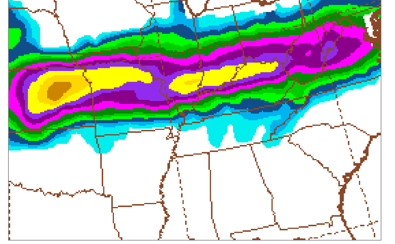
https://mag.ncep.noaa.gov/Image.php
We've been tracking the actual weather closely at these links:
Evansville Winter Storm 1-4-25+
Started by metmike - Jan. 5, 2025, 12:26 a.m.
https://www.marketforum.com/forum/topic/109322/
Midwest- Tracking the Winter Storm 1-4-25+
Started by metmike - Jan. 4, 2025, 9:21 p.m.
I have experienced THUNDERSNOW only 2 times in my life. Dec 1, 1974 in Detroit during a 15+ inch snowstorm(3 days after Thanksgiving-University of Detroit was closed for 2 days)
https://www.weather.gov/dtx/GhostofThanksgivingWeekendSnowstormofthePast
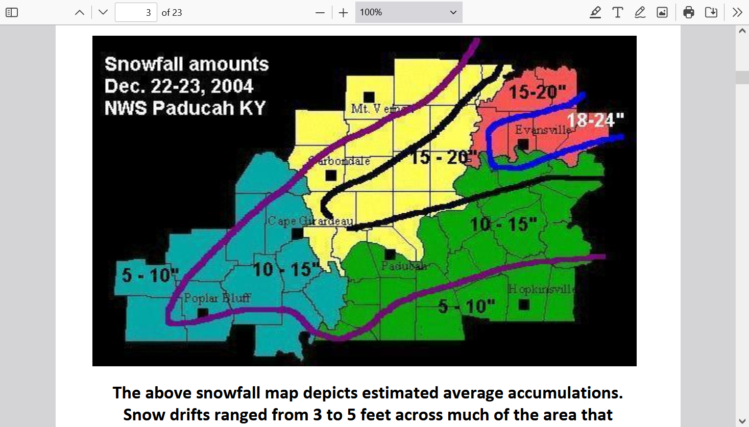
Then December 22, 2004 in Evansville during our 2 foot snowstorm. Anybody at least 30 today, that lived here remembers that one!
...Record snowfall up to two feet paralyzed much of the region...
Evansville - 22.3 inches (19.3" on Dec. 22 and 3.0" on Dec. 23). This storm set a new 24-
hour snowfall record, and made this the second snowiest December for Evansville.
Paducah - 14.2 inches. This storm set a new 24-hour snowfall record, and made this the
snowiest December for Paducah.
https://www.weather.gov/media/pah/Top10Events/2004/Dec22_2004Snowstorm.pdf
Considering the dynamics of this system, there's an outside, very small chance to have a flash of lighting/clap of thunder during it's peak later today but at the time, we would probably be having heavy freezing rain and it would be technically called "Thunderice". If sleet is falling, it's called "Thundersleet"!
The intensity of the rain would keep it from sticking, which would be good news, on the other hand, with the snow underneath it, does it add to the weight or not???