
Click a location below for detailed forecast.
Latest computer numbers.
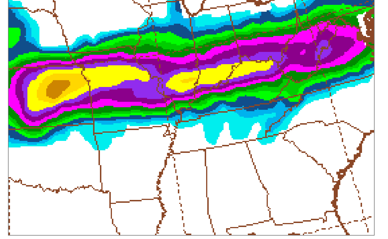
Around 3 inches of snow with a lot of sleet! then, .43 inch of freezing rain mixed with sleet, then finishing with another 1 inch of snow.
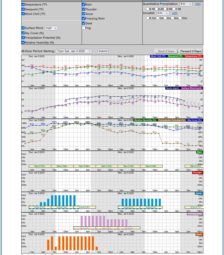
Zoomed in:
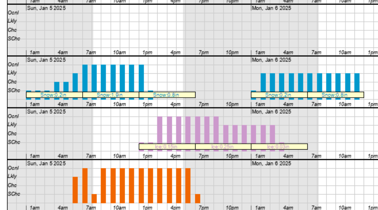 Pink =freezing rain
Orange=sleet
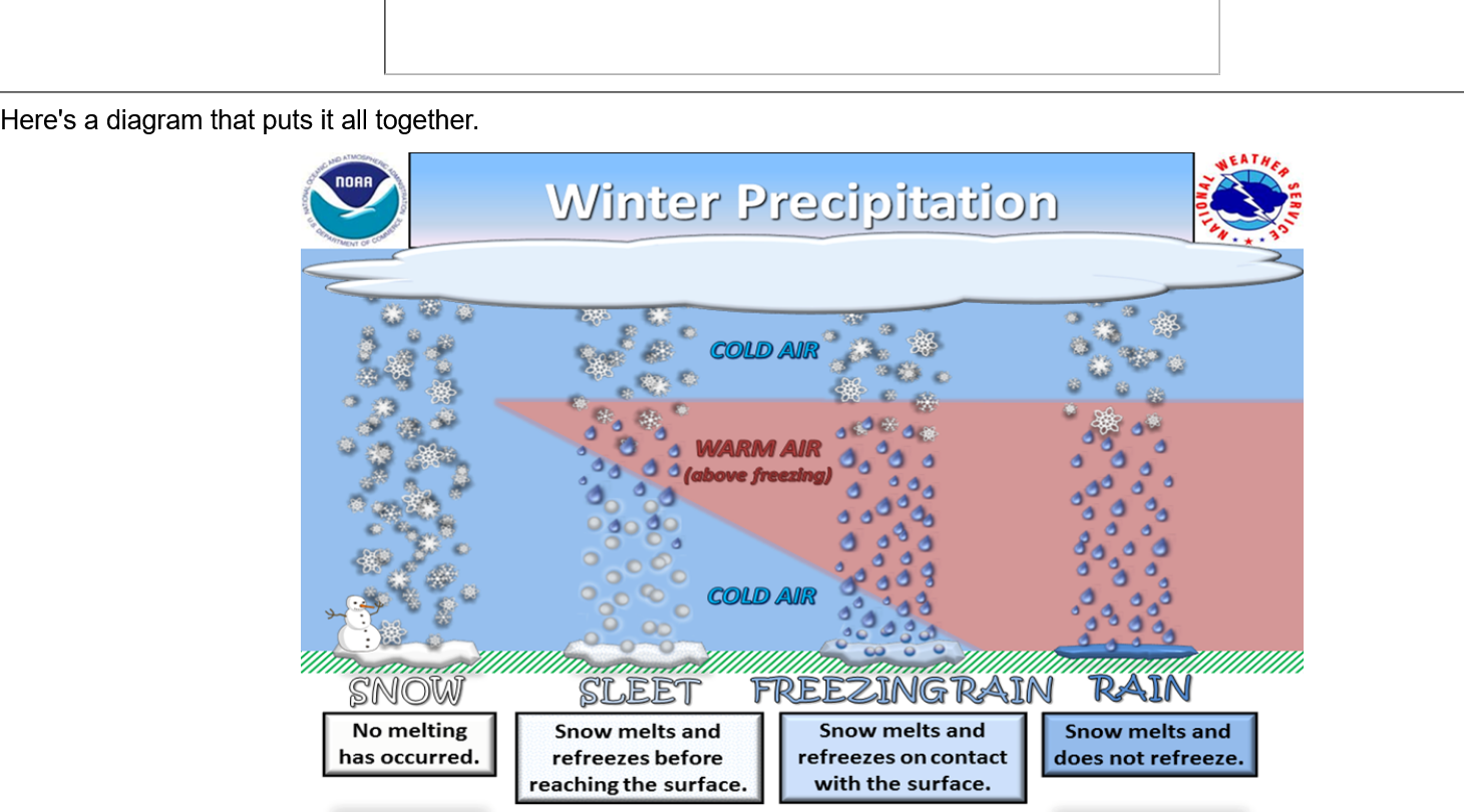
https://www.weather.gov/iwx/sleetvsfreezingrain
Hey Mike,
Be safe, bundle up, and hope you enjoy it!
Thanks very much, Larry!
We should note the yellows and especially bright oranges on the radar early this morning. I'll do a freeze frame to view for readers later today to see what it was like at the current 6am.
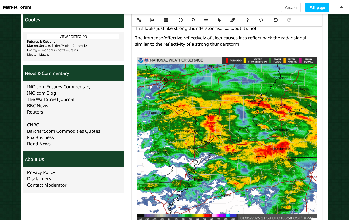
This looks just like strong thunderstorms............but it's not.
The immense/effective reflectively of sleet causes it to reflect back the radar signal similar to the reflectivity of a strong thunderstorm.
Below is what the radar looked like at 5:58 am. Yellows and especially oranges are mostly SLEET.
What this means is that the expected warmer pocket of air, which will change the snow into sleet and freezing rain is coming in slightly warmer and earlier.
That means initial snow amounts might be less and the heaviest ice, instead of being just south of the Ohio River may be just north of the Ohio River, including Evansville.
With that being the case, the NWS may need to shift their Ice Storm Warning farther north into Indiana to replace the Winter Storm Warning.
The numerical computer guidance below is sort of catching on to this but still has 3 inches of snow mixed in with the sleet initially. Not sure if that will verify but we might be in for a huge amount of sleet, then MORE FREEZING RAIN THAN WHAT WAS IN THE EARLIER FORECAST LATER TODAY.
9am update: We've already had almost 5 inches of snow!
Adjustments like this are not usual in a weather forecast like this, where 1 degree difference is huge to the precipitation type. This is called NOW-casting when the meteorologist quickly reconciles observations of the actual atmospheric reality with the previous expectations.
We should note that ice(freezing rain) amounts have now been boosted to .55 inches IN EVANVILLE as seen below and it starts just BEFORE noon.
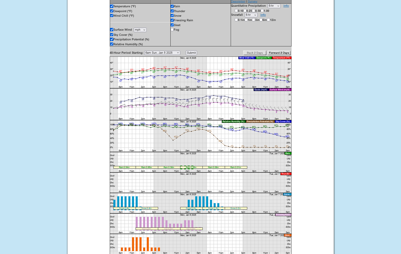
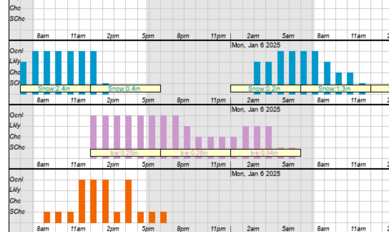
The good news is that surface temperatures have also been warmed slightly to 31 degrees as the afternoon goes on. The heavy amounts of liquid rain falling from the warm pocket aloft may warm the surface up to almost freezing.
The intensity, along with it being almost at the freezing point, will hopefully prevent some to even much of the falling freezing rain this afternoon/evening from sticking and collecting on elevated surfaces. We can't know for sure at this point.
For sure, the heavier amounts of liquid rain will end up causing RUNOFF on the ground INSTEAD OF FREEZING in many locations. Each location will be subject to different impacts, depending on the different topography/terrain, elevation above or at the surface and run off dynamics. This is still not likely to be anything like the 2009 ice storm because temps will get so close to freezing and there is no Arctic high to our north, like in that storm that wedged in the dense cold air at the surface and kept temps WELL below freezing during the entire event.
Here's a review of the 2009 ice storm and why this one IS DIFFERENT:
Re: Winter weather ahead 12-30-24
By metmike - Jan. 3, 2025, 6:20 p.m.
By metmike - Jan. 5, 2025, 12:36 a.m.
This was from the just out, 0z GEFS (American) ensemble model. A tad colder and a slight shift south with heavier snow totals for Evansville. Close to 10 inches if you believe this. However, freezing rain in the afternoon, heavy at times may cut back on that amount. If, however the models are too warm .......even by a couple of degrees, then we WON'T have a lengthy period of freezing rain and the snow could reach a foot.
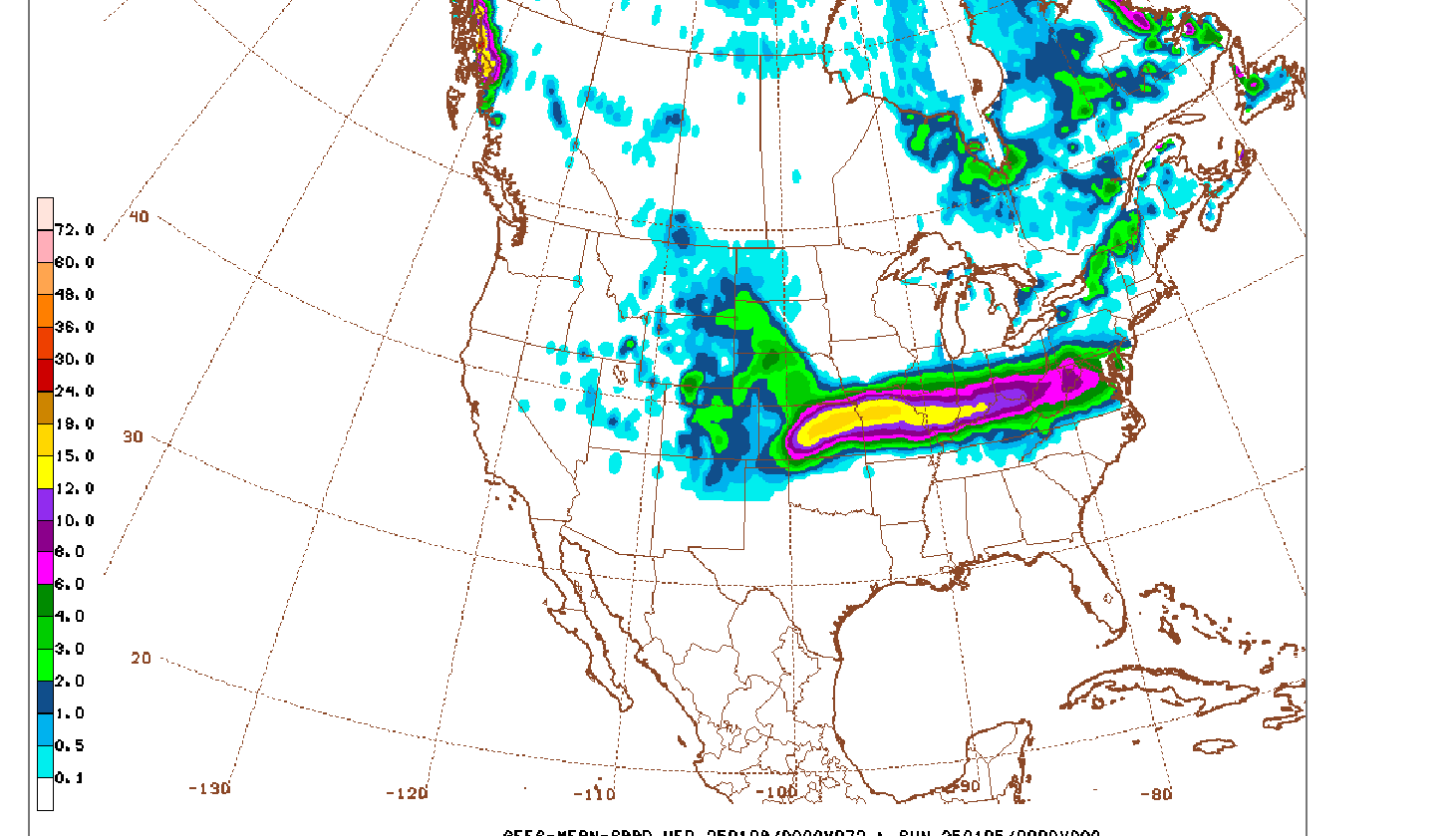
++++++++++++++++++
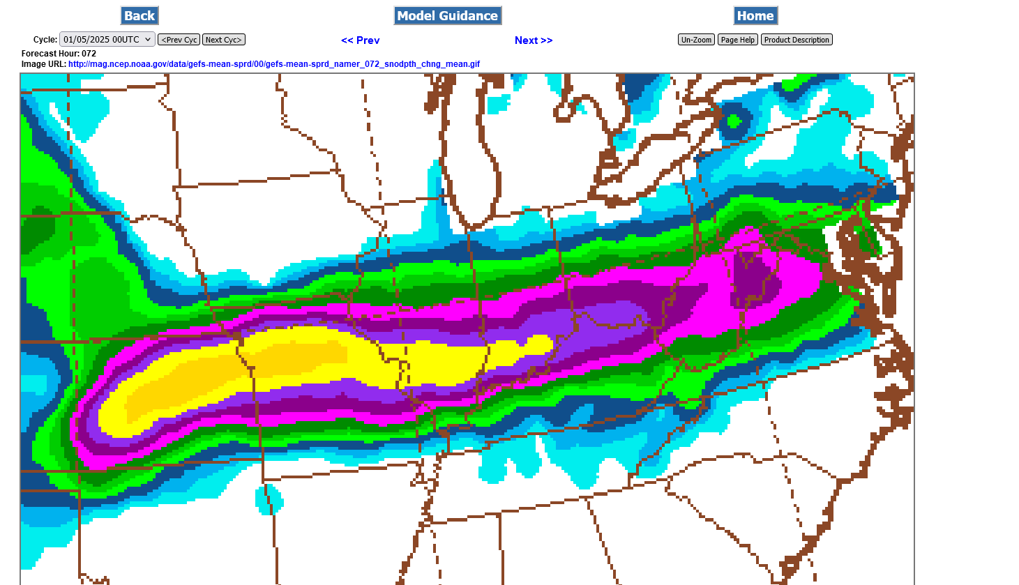
Update at 6am: Despite the reality of it being just a tad warmer than models this morning this just out 6z GEFS, below is not backing down on the forecast for snow amounts. Current and future forecasts are not going to be comparable anymore because of the NEW snow already fallen will no longer be part of our updated forecasts. It was still predicted snow in the earlier forecasts.
In fact, this last model forecast, just 30 miles northwest of Evansville, has a small 15+ inches snow band in darker yellow. At this point, we may need to throw the models out the window and do what's called NOW casting, at least for Evansville. The time stamps at all these posts, by the way are all in EASTERN time, something that I can't control.
Seriously, we are so close to the southern edge of the super heavy snow/sleet with an extraordinarily tightly packed gradient and models are not capable of fine tuning with enough skill to accurately tell us the exact vertical temperature profile to within the critical 1 degree difference that is needed to have confidence of forecasting exactly how much of what the north side of Evansville will get this morning.
It is very likely though, that mostly freezing rain will dominate this afternoon and evening.
Re: Re: Re: Evansville Winter Storm 1-4-25+
By metmike - Jan. 5, 2025, 7:14 a.m
+++++++++++++++
https://mag.ncep.noaa.gov/Image.php
There's another complicating element related to basic physics/meteorology. When we start out with air this dry initially, when precipitation starts falling it evaporates falling down into the dry air and causes evaporative cooling of the atmosphere.
So even with the slightly warmer air coming in a short while ago, the EVAPORATIVE COOLING can more than offset that and you end up a tad colder for several hours and the precipitation can change BACK to snow from sleet or back to sleet from freezing rain.
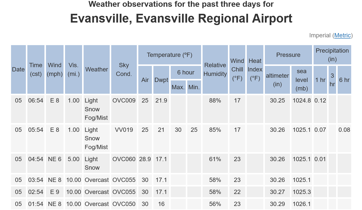
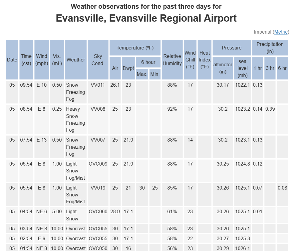
Between 4am and 6am, the temperature in Evansville DROPPED 5 degrees from 30 to 25 because of this!
As the air becomes saturated this stops. The dew point has jumped up from 17 to 22, with the humidity going from 58% to 88%, all because of the light snow falling into the dry air at the surface. This caused evaporative cooling AND is quickly saturating the lower levels of the air mass...... so we're pretty close to 100% saturation and will stay there for most of this event.
https://forecast.weather.gov/data/obhistory/KEVV.html
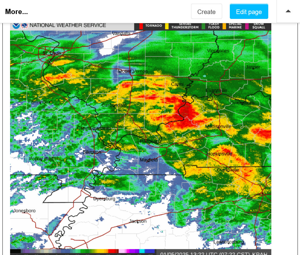
Its almost 7:30 am and here on the north side, its been mostly snow. Maybe an inch so far. Make that close to 2 inches.
Let's point out something profound on this frozen image of the radar. If you go by the color coding of yellow and orange at the top of the image(movement is west/southwest to east/northeast, Evansville is about to get clobbered by a severe thunderstorm/tornado!!!!
Nope! This is what SLEET looks like on the radar!
8:33am: Update below: It's now 1hour later. The cells above producing sleet at 7:30 am have moved to Evansville into A COLDER ATMOSPHERE where they are producing moderate to heavy SNOW with huge flakes. In Henderson and Owensboro where its a tad warmer, they are still likely making some sleet.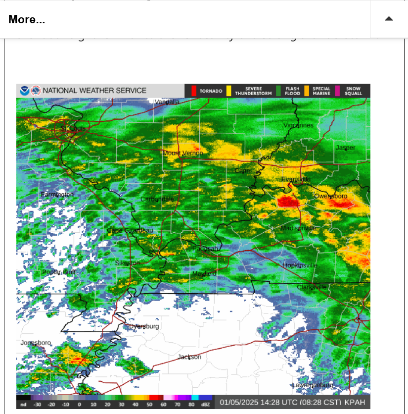
Update 8:45 am: I just measured 4+ inches outside, now mixing with sleet for the first time.
++++++++++++++++++++
THUNDERSNOW:
Re: Re: Winter weather ahead 12-30-24
By metmike - Jan. 5, 2025, 9:18 a.m.
+++++++
9am: This heavy snow on everything(almost 5 inches now) BEFORE it turns to freezing rain later may be a blessing. The freezing rain, instead of adhering and bonding directly and strongly to exposed surfaces, will instead be on top of heavy snow, which is loosely bonded to those surfaces.
However, this is an extraordinarily rare event that I've never experienced exactly like this. Heavy snow, followed by heavy sleet/freezing rain. Does the heavy rain soak the snow and make it extremely heavy, while still sticking or does it wash it off?
Additional speculative thoughts earlier(when snow amounts looked like less):
Re: Re: Re: Re: Evansville Winter Storm 1-4-25+
By metmike - Jan. 5, 2025, 7:44 a.m.
9:45 am: Just finished filling up all of our bird feeders outside of the living room window and measured almost 6 inches of snow.
The snow was falling at almost 2 inches/hour when I first went out there.
https://www.wunderground.com/maps/radar/current
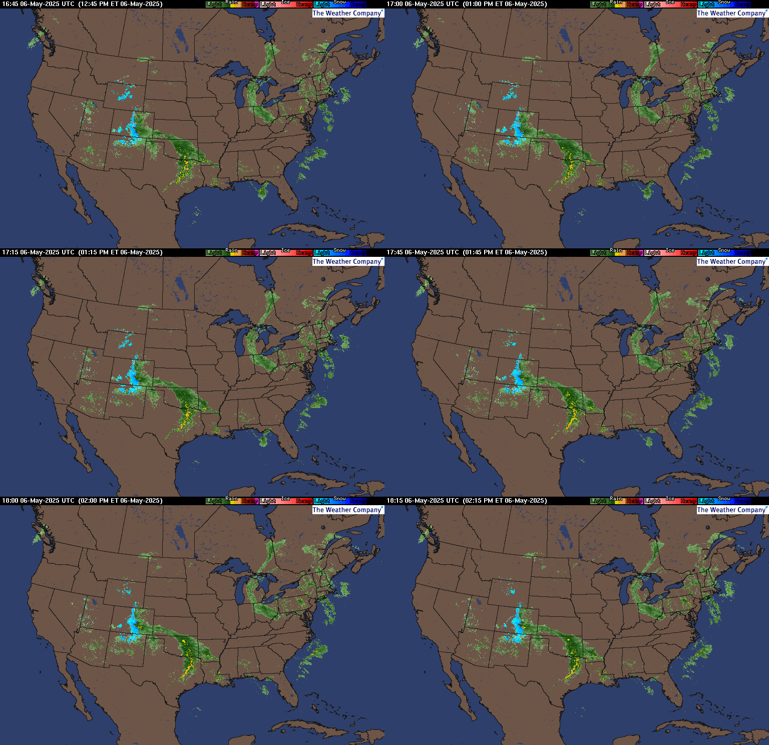
We have experienced that mess. Growing up we had livestock. If we had that weather we would have to start moving snow now......or it would be a major mess to move. The forecast is for more snow on top of that ice. And more and colder weather to follow,,,,,to compound the clearing for access to water and feed for animals. So in short if you want the easier routed move what you can earlier.
Thanks very much, mcfarm!!!
I'm sure events like this are NOT very welcome to animals living outside and those that care for them. The cold later this week will take temps to near 0 on a couple of mornings.
We've changed to mostly sleet a short while ago, after what appears to be around 6 inches of snow. The heaviest snow may be over now. Sleet, then long duration freezing rain this afternoon into the evening when it may be freezing drizzle for awhile towards midnight before going back to snow very early Monday and a couple more inches.
https://forecast.weather.gov/data/obhistory/KEVV.html
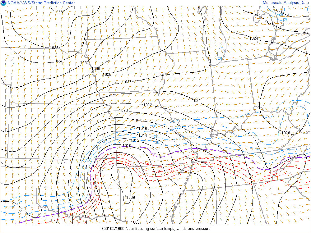
Here's the surface low with isobars/lines of equal pressure.
The purple line is the 32 degree/freezing surface temperature that will creep up to the Ohio River later today. The dashed blue lines above it/colder are spaced 2 degrees apart. The dashed red lines below it/warmer are also 2 degrees apart.
https://www.spc.noaa.gov/exper/mesoanalysis/new/viewsector.php?sector=20#
The Storm Prediction Center has a risk of severe storms well to our south today but the light green shade means an atmosphere unstable enough for a SLIGHT chance for Thundersnow/Thundersleet or Thunderice.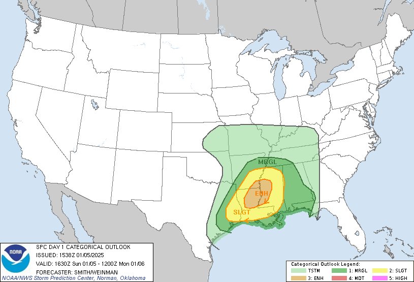
+++++++++++++++
Re: Re: Winter weather ahead 12-30-24
By metmike - Jan. 5, 2025, 9:18 a.m.
I have experienced THUNDERSNOW only 2 times in my life. Dec 1, 1974 in Detroit during a 15+ inch snowstorm(3 days after Thanksgiving-University of Detroit was closed for 2 days)
https://www.weather.gov/dtx/GhostofThanksgivingWeekendSnowstormofthePast
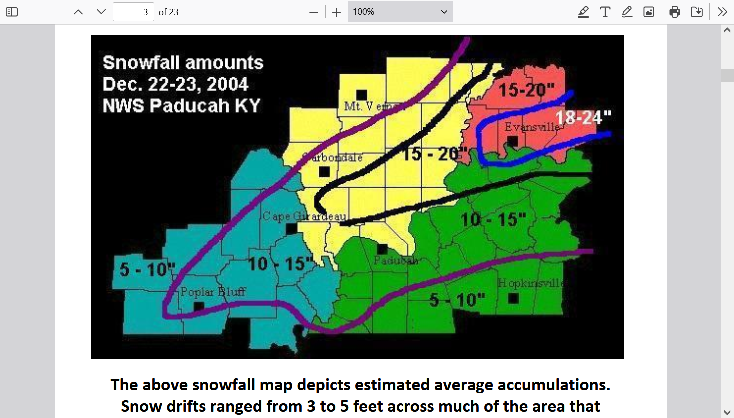
Then December 22, 2004 in Evansville during our 2 foot snowstorm. Anybody at least 30 today, that lived here remembers that one!
...Record snowfall up to two feet paralyzed much of the region...
Evansville - 22.3 inches (19.3" on Dec. 22 and 3.0" on Dec. 23). This storm set a new 24-
hour snowfall record, and made this the second snowiest December for Evansville.
Paducah - 14.2 inches. This storm set a new 24-hour snowfall record, and made this the
snowiest December for Paducah.
https://www.weather.gov/media/pah/Top10Events/2004/Dec22_2004Snowstorm.pdf
Considering the dynamics of this system, there's an outside, very small chance to have a flash of lighting/clap of thunder during it's peak later today but at the time, we would probably be having heavy freezing rain and it would be technically called "Thunderice". If sleet is falling, it's called "Thundersleet"!
The intensity of the rain would keep it from sticking, which would be good news, on the other hand, with the snow underneath it, does it add to the weight or not???
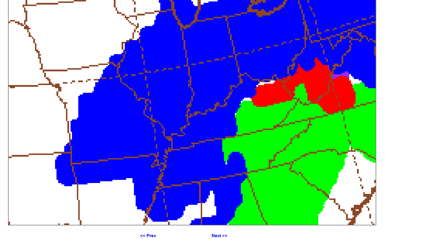
The latest 12z GEFS is just out. Since some of the precip has fallen, I'll just show the TYPE expected during the rest of this event. Most of our heavy snow is over now and we''ll see a period of sleet, then freezing rain of long duration, maybe freezing drizzle, then finally back to snow very early Monday morning.
1. 12 noon(an hour from now) The purple is sleet for us.
2. 6pm. Solidly in the red/freezing rain.
3. Midnight. Still solidly in the red, freezing rain diminished and maybe freezing drizzle then. Turning blue again by 4am when accumulating snow returns on the backside of the storm.
4. 6am Monday. Solidly blue with snow ending BEFORE Noon.
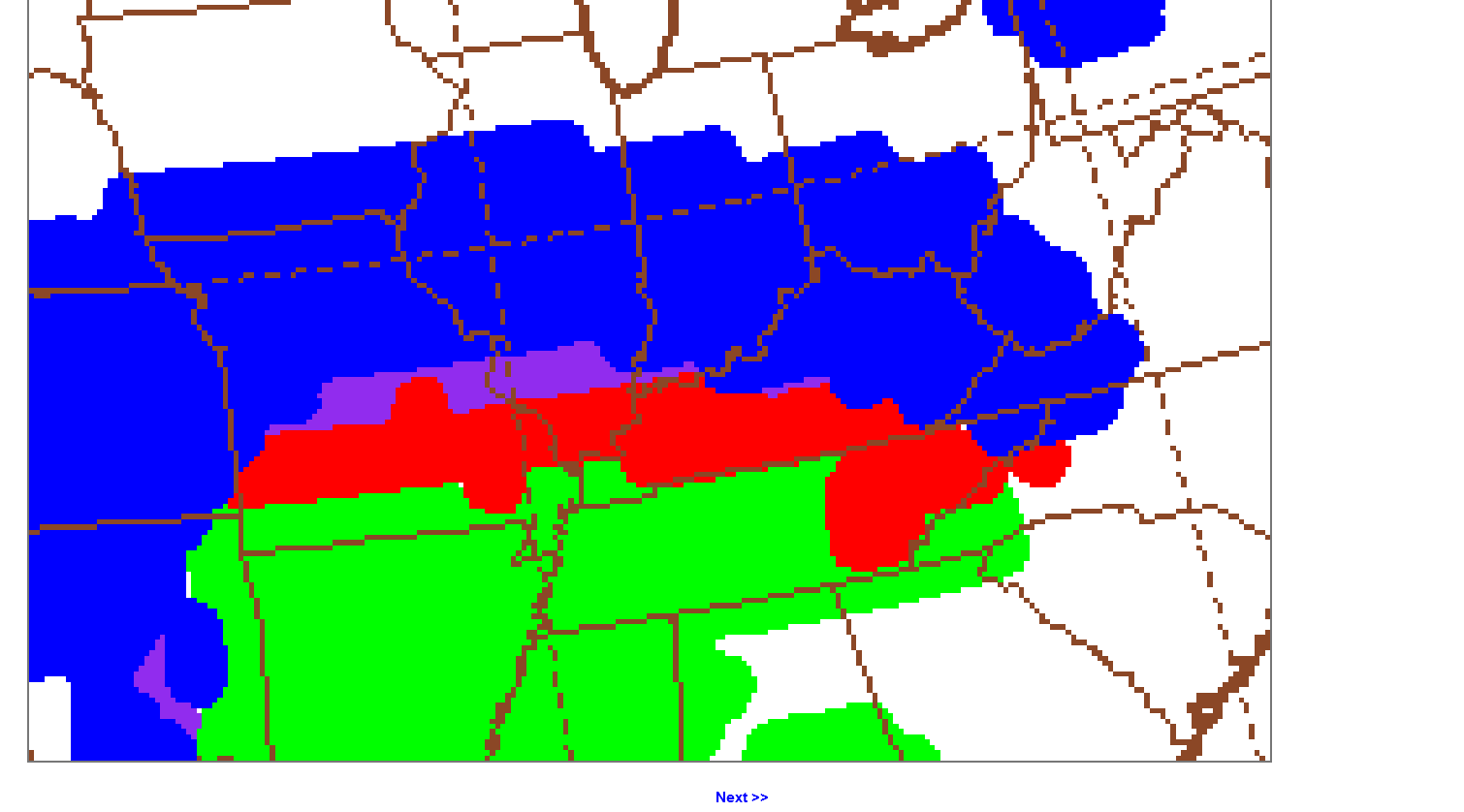
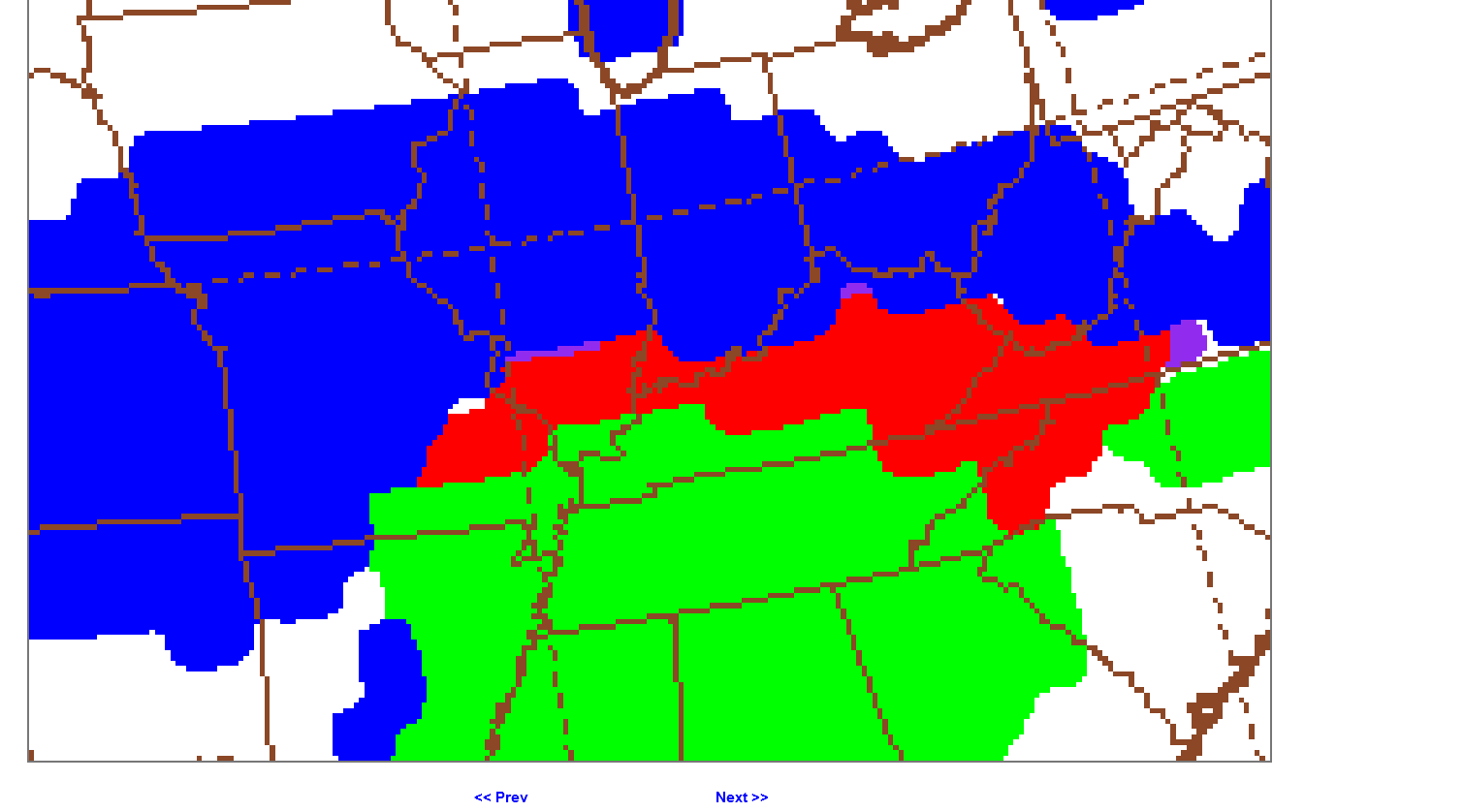
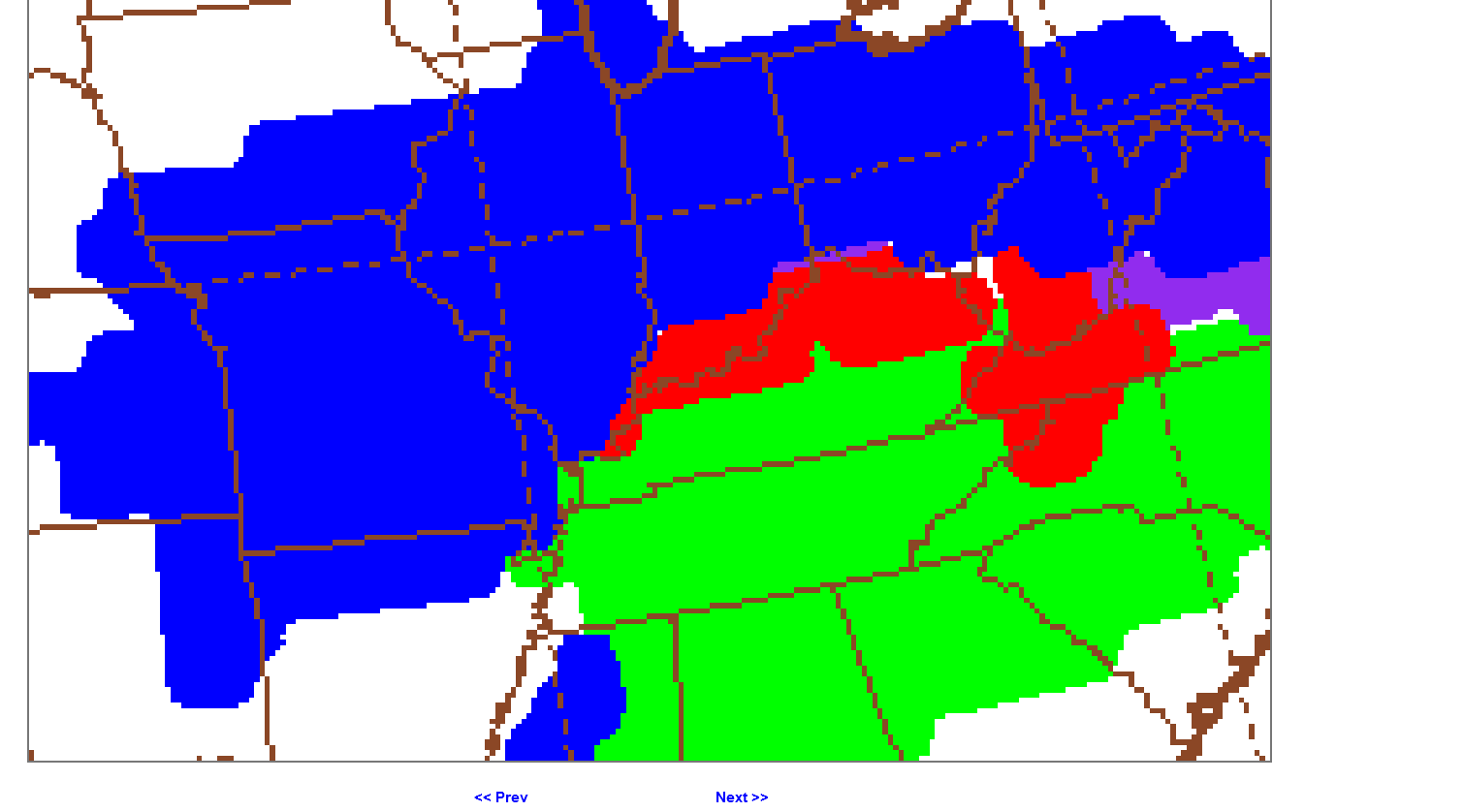
 +++++++++++
Updated numerical guidance numbers below look pretty good/are consistent with the above.
Blue=snow, about ended for us(moderate sleet outside at 11am), then returning after midnight Monday for another 2 inches?
Pink=freezing rain=.56" the next 14 hours mixing with sleet early afternoon
Orange= sleet, ending for good by mid afternoon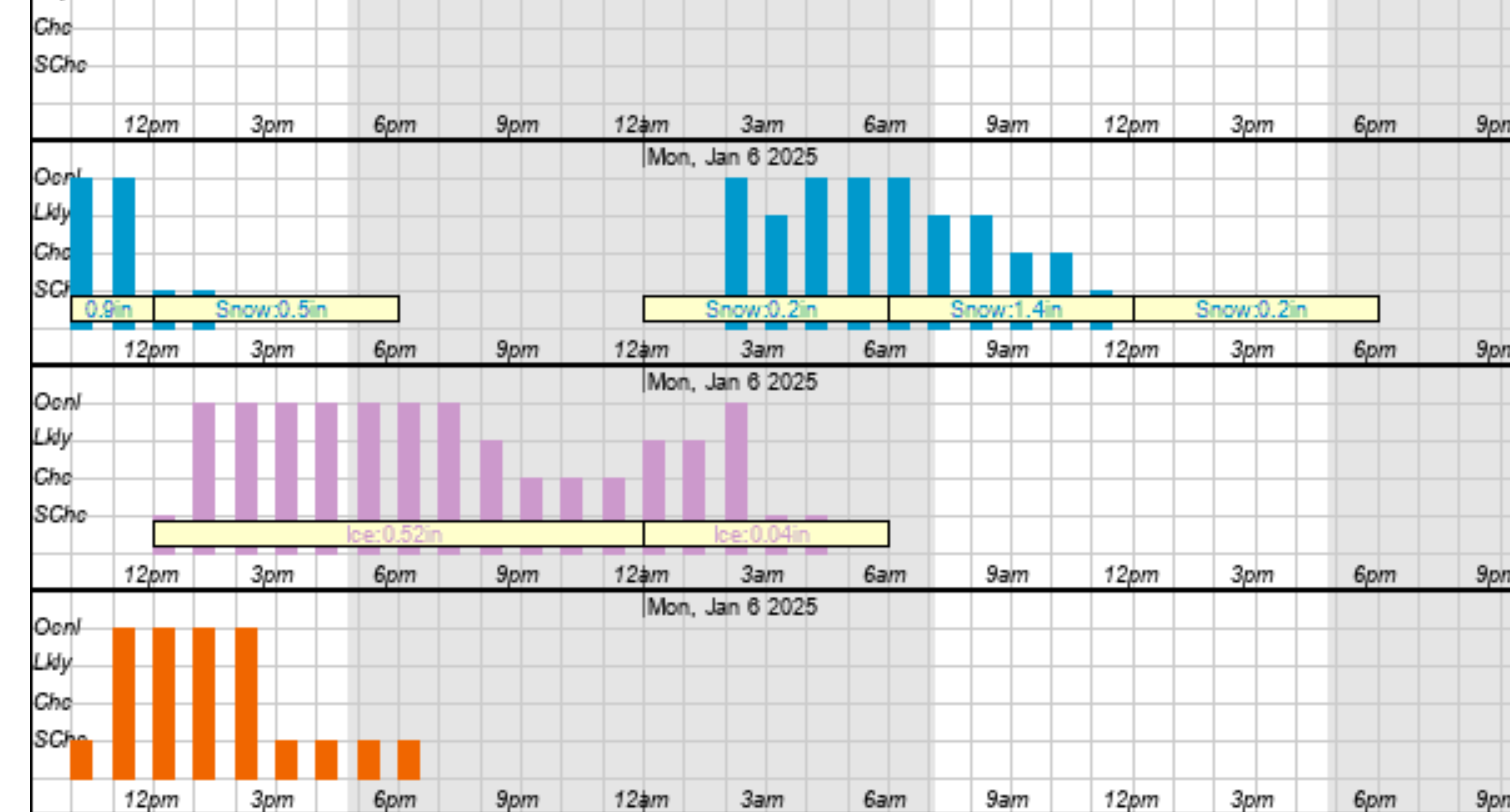
HEAVY STUFF about to hit Evansville!
Is this from some increased sleet reflectivity or might we have some thunderice from the freezing rain intensity really picking up as expected?
I'll say sleet!
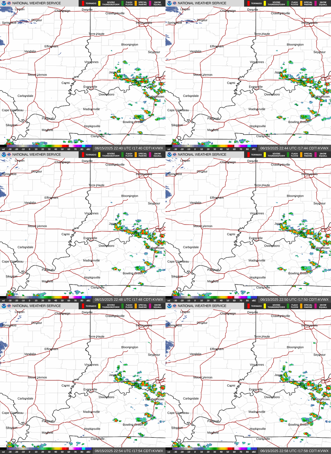
That only took a few minutes. We've got sleet falling!
Also, the 6 inches of snow this morning was more than enough so that this freezing rain is soaking into the top of it and forming a very hard, thickening crust at the top, at least on the ground and is not going to be melted or washed away without a gully washer and temps getting above 32.
This will make for a challenging time in shoveling it off of sidewalks and driveways. However, its still better than having freezing rain from the get go that's adhered directly to the pavement that has to be MELTED OFF with chemicals or warmth.
Also, sleet right now is the best thing for elevated surfaces like trees and power lines. Sleet is very slippery and will not stick. GO SLEET!
+++++++++++++
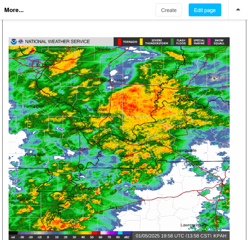
2:30pm: This approaching radar signature is one that I can't ever remember seeing from a Winter Storm (not severe weather). This is a 2:28pm image below. We can see the circular pattern of the beam being reflected back at the Gibson county radar site(green dot in the center, northwest of Evansville), especially to the south. Not from high topped severe thunderstorms but from low level sleet.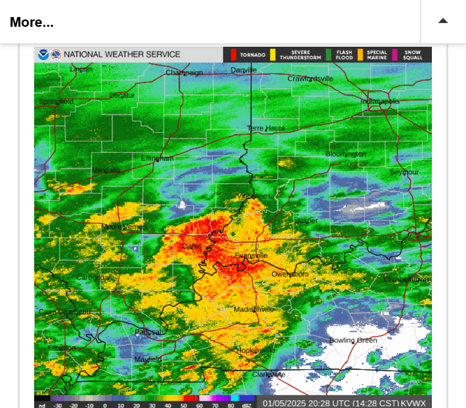
2:57pm: Hats off to the numerical guidance below for actually predicting this sleet in orange. It was too low for snow totals this morning though. I think the rest of this event will play out close to what the graph below depicts.
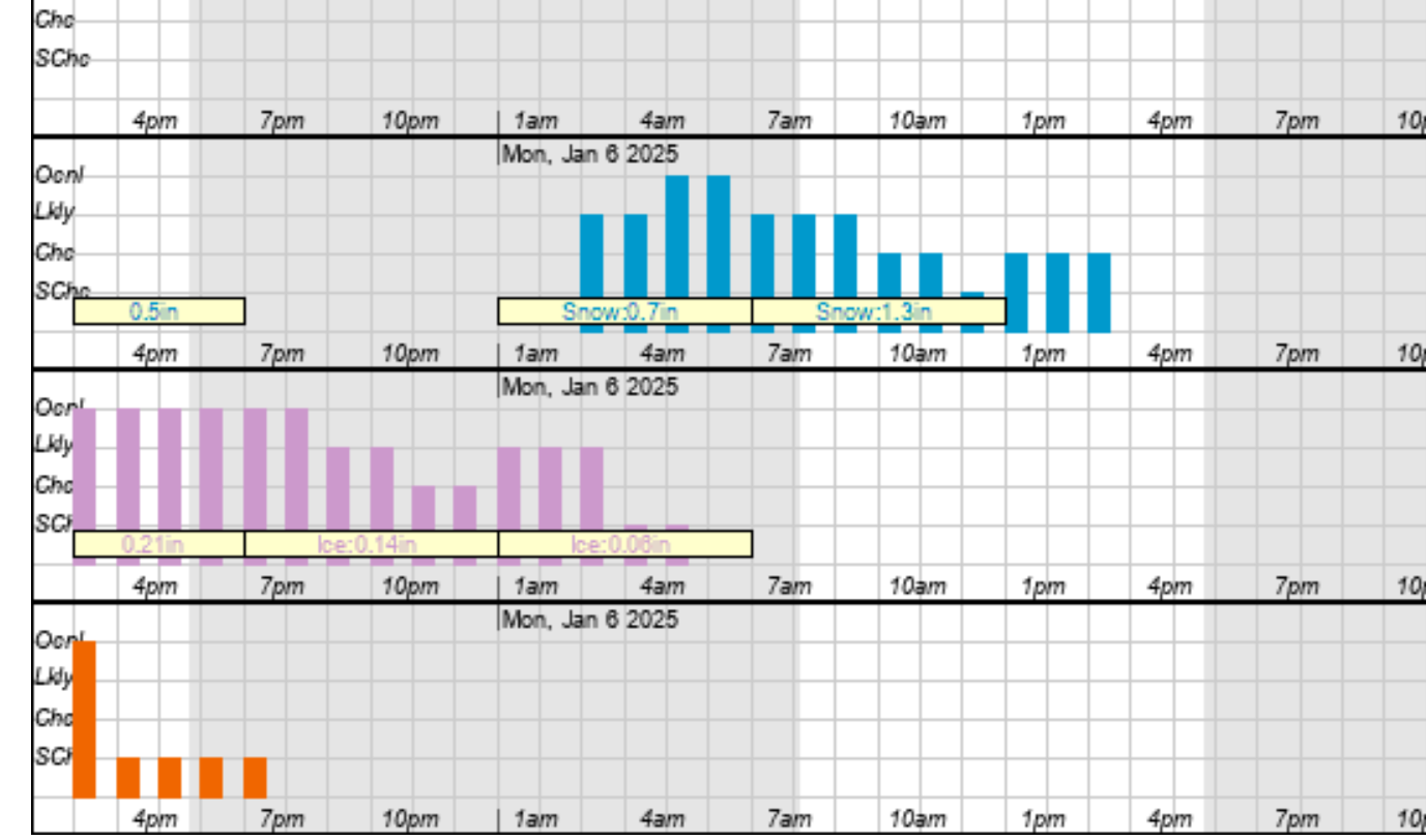
Get the latest graph here:
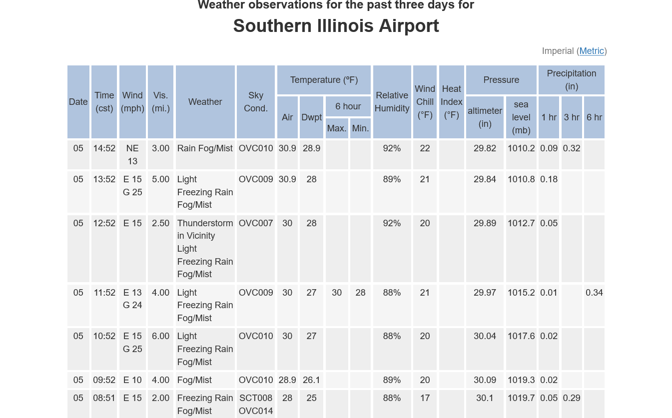
There have been reports of Thunderice from this Winter Storm in some locations.
This is from Southern Illinois: Just before 1pm when they had the Thunderice!
https://forecast.weather.gov/data/obhistory/KMDH.html
+++++++++++
Added: I see that Paducah, KY had a Thunderstorm with a temp of 34 degrees around the same time:
https://forecast.weather.gov/data/obhistory/KPAH.html
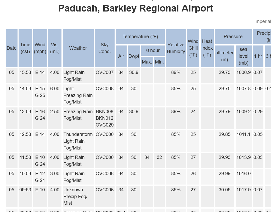 Not sure of this but I may have heard a rumble of thunder with this big patch of sleet that hit before 3pm.
3:45pm: Still numerous hours of freezing rain to go:
https://www.wunderground.com/maps/radar/current

Winds are gusting close to 30mph, not what we want with ice collecting on elevated surfaces, although the heavier intensity of this freezing rain may be doing more melting on elevated surfaces than collecting.
Later this evening, the intensity is going to drop to just DRIZZLE but if we are below freezing, it will be freezing drizzle and have the chance to collect on elevated surfaces.
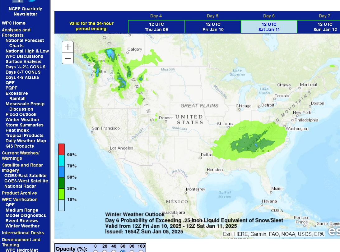
A new MINOR Winter storm for this Friday has been showing up in recent guidance.
This one will pass farther south and, at the most produce some lighter accumulating SNOW only in Evansville, if it tracks that far north.
https://www.wpc.ncep.noaa.gov/wwd/pwpf_d47/pwpf_medr.php?day=6
We lucked out here. NO rain or snow ! WC Illinois. We were on the northern edge of the storm. Forecasted to get a couple inches of snow or a lot more if it shifted north. As of 5:30 pm... nothing. My cows are happy.
Glad for you, bowyer!!!
cutworm,
That's an awesome site. I should have been using it earlier!
Jim Cantore from the Weather Channel gets all pumped up from Thundersnow over Kansas City!
In 1981, after graduation I applied to work at the Weather Channel right out of college when they were still forming via John Coleman. That would have been my dream job, working with dozens of other meteorologists all day.
Ronald Reagan had put a 1 year job freeze on hiring any new federal employees which put the kibosh on working at the NWS out of college(my initial goal).
The Weather Channel told me they only wanted experienced meteorologists.
Turns out that Dale Dakus working at WeatherScence/WLWT channel 5 in Cincinnati had the experience, so they hired him...........but that place needed somebody to replace Dale.........that was me in February 1982!
I got the experience doing radio and industrial client weather forecasts.
In September 1982, I came to Evansville, IN to be chief meteorologist, signing a 3 year contract, after which planning on moving up. In September 1985 with the contract ready to expire, the Weather Channel CALLED ME!
Yippeee!
But something else happened. In August 1985, I got married to my wonderful wife. Her entire family lived here, as well as her 6 year old daughter that was going to school. She also had a solid job in the electroplating business.
Family came first, career came 2nd.
No regrets!
The measurable freezing rain is about to end. In fact, last hour we popped up to 33 degrees, just above freezing so technically, maybe we should just call it light freezing rain.
https://forecast.weather.gov/MapClick.php?x=285&y=84&site=pah&zmx=&zmy=&map_x=285&map_y=84
Current conditions at
Lat: 38.04°NLon: 87.52°WElev: 417ft. 
Light Freezing Rain Fog/Mist
33°F
1°C
| Humidity | 89% |
| Wind Speed | NE 13 mph |
| Barometer | 29.75 in (1008.0 mb) |
| Dewpoint | 30°F (-1°C) |
| Visibility | 4.00 mi |
| Wind Chill | 24°F (-4°C) |
| Last update | 5 Jan 8:54 pm CST |
+++++++++++++++++++
I expect some light drizzle/fr. drizzle for possibly another 5 hours.
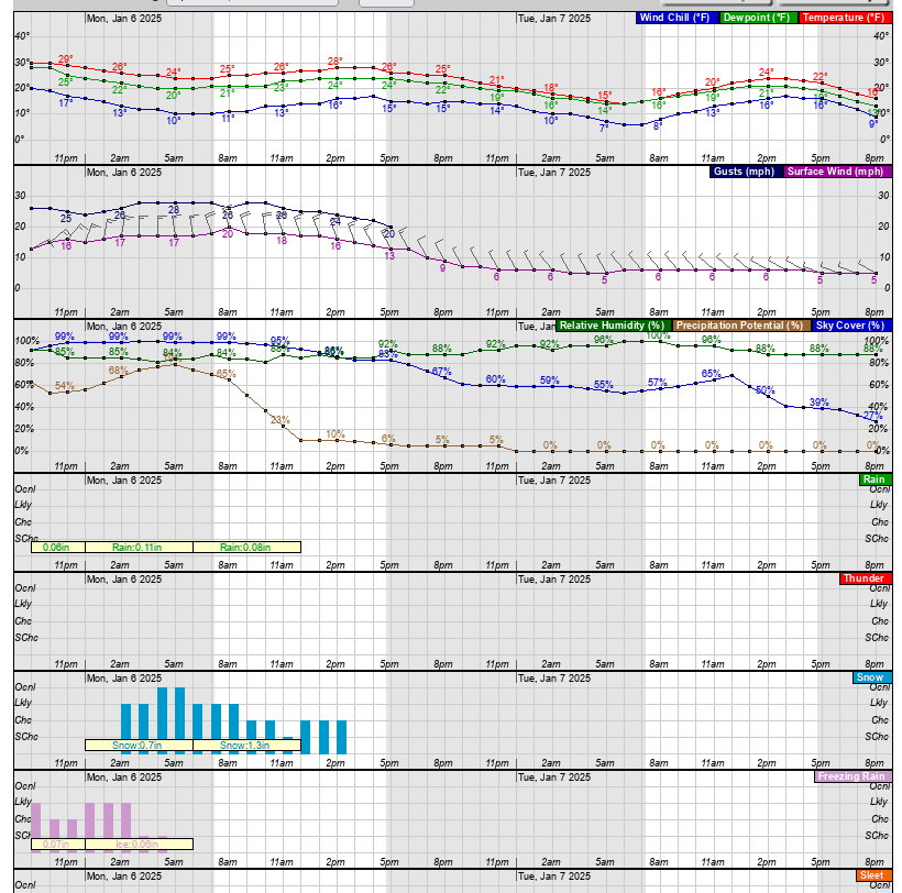
Then on the backside of the storm, up to 2 inches of snow on Monday morning with temps back in the 20's, followed by 4 days in the deep freeze.
https://www.wunderground.com/maps/radar/current

Last of the precip on the front side of the storm exits below.
This will be followed by a dry wedge, now in IL and drizzle for 5 hours, then snow currently over St. Louis gets here well before dawn for another 2 inches on Monday Morning.
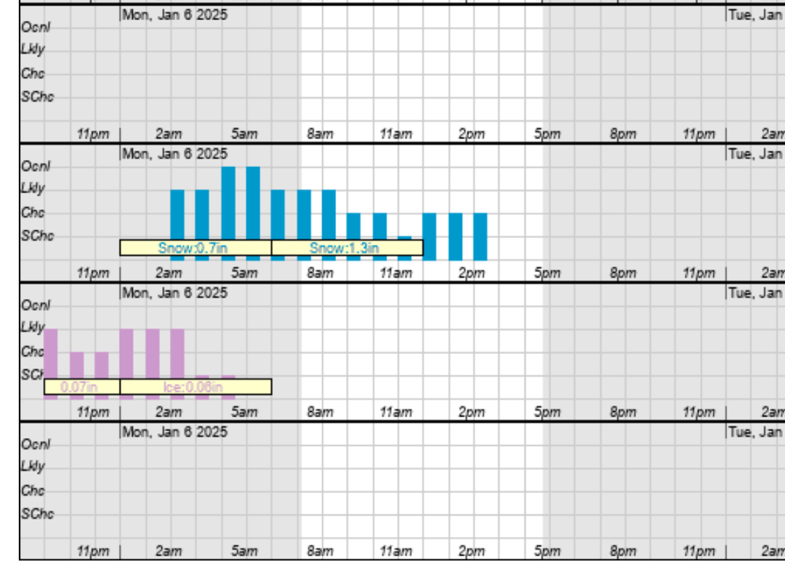
Latest computer numbers look good but with winds shifting back to the north, gusting to 30 mph colder air will drop temps back into the 20's and everything not treated will refreeze, with another 2 inches of snow.
Mike
Is the storm over for you? Recap, please---when to when, type, total
Intersection I80 and IllRt 71 had nothing, Ottawa, LaSalle County, Illinois
Hi tjc,
Weve been out of power some of the time with 0 internet, cable and phone service since very early this morning.
im tethering off my sons cell phone right now, Verizon has service-NOT AT AND T after spending the last 3 hours shoveling all the snow and ice off our long driveway.
theres nothing more that i would love to do than to pick up where i left off last night………when my computer can get back online.
thanks for waiting
My son has my computer tethering to my cell phone (which is working again) so I should be able to add more information now.
cutworm lives in Southeast Indiana, not too far from Cincinnati, OH:
snow in my area
Started by cutworm - Jan. 5, 2025, 10:06 a.m.
https://www.marketforum.com/forum/topic/109335/
More Midwest reports here:
Here's a list of places closed again on tomorrow.
https://www.14news.com/weather/closings/
Types
States
| Organization | Status | Type |
|---|---|---|
| ABK (AAPS/DAPS Only) | Closed Tuesday | Business-IN |
| Aces Disposal | Closed Tuesday | Business-IN |
| Active Day of Owensboro | Closed Tuesday | Business-KY |
| Advanced Anti-Aging Center of Excellence | Closed Monday | Business-IN |
| Advanced Vision Associates | Closed Tuesday | Business-IN |
| Advent Veterinary Services | Closed Tuesday | Business-IN |
| Alexandrian Public Library | Closed Tuesday | Other-IN |
| AMECO | Closed Tuesday | Business-IN |
| Audubon Area Community Services | Closed TuesdayGRITS will run with limited service. | Business-KY |
| Ba's Kitchen Konnection | Closed Tuesday | Business-IN |
| Behind The Wheel Driving Academy | Closed Through 01/07Drives Canceled/Office Closed Monday and Tuesday | Business-IN |
| Best Home Furnishings | Closed TuesdayOpen Wednesday | Business-IN |
| Bethel Church-Evansville | Closed TuesdayOffice Closed / Activities Canceled | Churches-IN |
| Bethel UCC - Evansville | Closed TuesdayBethel Buddies Preschool Closed | Churches-IN |
| Boonville Christian School | Closed Tuesday | Schools-IN |
| Boonville-Warrick County Public Library | Closed Tuesday | Business-IN |
| Brescia University | Closed Tuesday | Schools-KY |
| Bright Beginnings Daycare | Closed TuesdayIn Jasper | Business-IN |
| Buffalo Trace Council | Closed Tuesday | Business-IN |
| CAPE Headstart Evansville | Closed Tuesday | Schools-IN |
| Carmi White Co. CUSD #5 | Closed Tuesday | Schools-IL |
| Castle Country Academics | Closed TuesdaySchool is closed due to weather | Schools-IN |
| Center for Pediatric Therapy | Closed Tuesday | Other-IN |
| Christ the King Catholic Church | Closed TuesdayParish offices closed 6am Mass SF will be offered | Churches-IN |
| Christian Church Day Care | Closed Tuesday | Schools-IN |
| City of Henderson, KY | Open Tuesday | Business-KY |
| Craftastic Vinyl | Closed Tuesday | Business-IN |
| Damsel Brew Pub | Closed Tuesday | Business-IN |
| Daviess County Schools KY | Closed TuesdayJanuary 7, 2025 will be "DCPS at home day #1" | Schools-KY |
| Dawson Springs Independent | Delayed 2 hours TuesdayNo breakfast | Schools-KY |
| Diamond Valley Federal Credit Union | Closed Tuesday | Business-IN |
| East Gibson Schools | Closed Tuesday | Schools-IN |
| Edwards County #1 | Closed Tuesday | Schools-IL |
| Edwin Kasha MD | Closed Tuesday | Business-IN |
| Evansville Catholic Schools | Closed Tuesday | Schools-IN |
| Evansville Christian | Closed Tuesday | Schools-IN |
| Evansville Day School | Virtual Learning Tuesday | Schools-IN |
| Evansville Eyecare Associates | Closed Tuesday | Business-IN |
| Evansville Eyecare Associates, Inc. | Closed Tuesday | Other-IN |
| Evansville Housing Authority | Closed TuesdayEssential staff will still need to report to work. | Business-IN |
| Evansville Lutheran School | Closed Tuesday | Schools-IN |
| Evansville Sheet Metal Works | Closed Tuesday | Business-IN |
| Evansville Vanderburgh Public Library | Closed Through 01/07 | Other-IN |
| EVSC | Closed Tuesday | Schools-IN |
| Fairlawn Children's Center | Closed Tuesday | Schools-IN |
| Family Dentistry-Drs. Schmitz, Fickas, Fabiano, and Biggerstaff | Closed Tuesday 01/07 | Business-IN |
| Fibertech | Closed Tuesday1st and 2nd Shifts Cancelled Tuesday 1/7 | Business-IN |
| GenTox | Closed Tuesday | Other-IN |
| Gibbs Die Casting | Open MondayOpening 3rd shift | Business-KY |
| Gibson Co. Senior Center | Closed TuesdayWill be closed, Tuesday, Jan 7. | Other-IN |
| Glow Aesthetic Medicine and Wellness | Closed Tuesday | Business-IN |
| Grace Christian Academy | Closed Tuesday | Schools-KY |
| Grading On A Curve Driving Academy LLC | Closed Tuesday 01/07 | Business-IN |
| Greater Jasper Consolidated School Corp. | Closed Tuesday | Schools-IN |
| H & H Music | Closed Tuesday | Other-IN |
| Hancock Christian Academy | Closed Tuesday | Schools-KY |
| HANCOCK CO PUBLIC SCHOOLS-KY | Closed Tuesday | Schools-KY |
| Harmony EyeCare | Closed Tuesday | Other-IN |
| Henderson Community College | Closed TuesdayOffices Open Virtually; Campus Buildings Closed | Schools-KY |
| Henderson County Schools | Closed Tuesday | Schools-KY |
| Heritage Christian School | Closed Tuesday | Schools-KY |
| Home Builder Solution LLC | Closed TuesdayRemote work only | Business-IN |
| Hometown Ophthalmology | Closed Tuesday | Other-IN |
| Hook's Apothecary | Closing Early Tuesday 03:00 PM | Business-IN |
| Hope Central Manna Market | Closed TuesdayHope Central/Boonville Closed Tuesday | Other-IN |
| Hopkins County School District | Closed TuesdayHCS@Home Day 3 | Schools-KY |
| Hugh Sandefur Training Center | Closed TuesdayElevate will be closed | Business-KY |
| Huntingburg United Methodist Church | Closed Tuesday | Churches-IN |
| IVY Tech Community College | Virtual Learning TuesdayBuildings Closed/Operating Virtually | Schools-IN |
| Jason M. Kuester, DDS, LLC | Closed Tuesday | Other-IN |
| John Paul II Catholic School | Closed TuesdaySnow Day; No NTI | Schools-KY |
| Joshua Academy | Closed Tuesday | Schools-IN |
| Joshua Academy Preschool | Closed Tuesday | Schools-IN |
| K.B.'s Kid Zone | Delayed Tuesday 1 HourClosing 1 Hour Early | Schools-KY |
| Kentucky Wesleyan College | Closed Tuesday | Schools-KY |
| Kiddie City Preschool LLC | Closed Tuesday | Schools-IN |
| Kidz Hair Club & Family Hair salon | Closed Tuesday | Business-IN |
| Kindergate Developmental Child Care | Closed Tuesday | Schools-IN |
| Lampion Center | Closed Tuesday | Business-IN |
| Law Offices of Steven L. Bohleber | Closed Tuesday | Other-IN |
| Life in Motion Family Wellness Center | Closed Through 01/07 | Business-IN |
| Lincoln Heritage Public Library | Closed Tuesday | Other-IN |
| Lincoln Hills Development Corporation | Closed TuesdayAll LHDC Offices on 1/7/2025 | Business-IN |
| Marshall Disposal | Alert TuesdayResidential and some commercial services closed | Business-IN |
| MasterBrand Cabinets, Inc. | Closed TuesdayDubois Co. plants 1st and Midshift & Jasper Office | Business-IN |
| McLean County Public Library | Closed Tuesday | Business-KY |
| McLean County Schools | Virtual Learning Tuesday | Schools-KY |
| McWilliams Vision Care | Closed Tuesday | Other-IN |
| Meals On Wheels of Evansville | Closed Tuesday | Business-IN |
| Medihealth PC with Dr Hubert Reyes | Closed Tuesday | Business-IN |
| Memorial Childcare Ministry | Closed TuesdayClosed Tuesday January 7, 2025 | Other-IN |
| Methodist Temple Children's Center | Closed Tuesday | Schools-IN |
| Midwest Ear Nose & Throat Surgery | Closed Tuesday | Business-IN |
| Montessori Academy | Closed TuesdayDaycare Closed - State of Emergency | Schools-IN |
| Mount Carmel Public Library | Closed Tuesday | Business-IL |
| MSD of Mt. Vernon | Closed TuesdayE-Learning Day | Schools-IN |
| MSD of North Posey County | Closed Tuesday | Schools-IN |
| Muhlenberg Co. Health Department | Closed Tuesday | Business-KY |
| Muhlenberg County Schools | Closed TuesdayNTI Day #3 | Schools-KY |
| NCOE | Closed Tuesday | Schools-IL |
| Newburgh Child Development / Caring Hands | Closed Tuesday 01/07 | Business-IN |
| Newburgh Christian Academy | Closed Tuesday | Schools-IN |
| Newburgh Family Dental | Opening Late Tuesday 01:00 PM | Business-IN |
| North Gibson Schools | Closed Tuesday | Schools-IN |
| North Spencer Schools | Closed TuesdayMake up day will be Monday, February 17th | Schools-IN |
| Northeast Dubois Schools | Closed Tuesday | Schools-IN |
| Ohio County Schools | Closed Tuesday | Schools-KY |
| Olney Central College | Closed Tuesday | Schools-IL |
| One Faith Fellowship | Closed Through 01/07Wednesday New Year Prayer 6:30PM | Churches-KY |
| Oral Surgery Group | Closed Tuesday | Business-IN |
| Owensboro Catholic Schools | Closed TuesdayOCHS Green Day. Scrip and Central Office closed. | Schools-KY |
| Owensboro Community and Technical College | Closed TuesdayVirtual Services Available 8 a.m. - 4:30 p.m. | Schools-KY |
| Owensboro Public Schools | Closed TuesdayNo NTI - Treat as Snow Day | Schools-KY |
| Parenting Time Center | Closed Through the 7th | Other-IN |
| Peace Zone, Inc. | Closed Tuesday | Business-IN |
| Pediatric Dentistry of Newburgh | Closed Tuesday | Other-IN |
| Perry Central Community Schools | Closed Tuesday | Schools-IN |
| Pike County Public Library | Closed Tuesday | Business-IN |
| Pike County Schools | Virtual Learning Tuesday | Schools-IN |
| Poseyville Carnegie Public Library | Closed Tuesday | Business-IN |
| Posh on Main | Closed Tuesday | Business-IN |
| Premiere Tan | Opening Late Tuesday 09:00 AM | Other-IN |
| Rehab for Life | Closed Through 01/07 | Business-IN |
| Republic Services | All Services CanceledResidential Collection Canceled Tuesday | Business-IN |
| Richland County Schools | Closed Tuesday | Schools-IL |
| Rising Stars Childcare | Closed Tuesday | Business-IN |
| Riverview School/Childcare | Closed Tuesday | Schools-KY |
| Road Star Driving School | Alert until further noticeALL Drives Cancelled | Business-IN |
| Rogers Academy of Hair Design | Closed Tuesday | Schools-IN |
| Senior Community Center | Closed Tuesday | Business-KY |
| Settle Memorial UM Church | Closed TuesdayPreschool/Afterschool Closed | Churches-KY |
| Signature School | Closed Tuesday | Schools-IN |
| Simpson United Methodist Church | Closed TuesdayOffice, food pantry & clothes closet closed | Churches-IN |
| South Gibson Medical Clinic-Dr. Emerson | Closed Tuesday | Business-IN |
| South Gibson Schools | Closed TuesdayAsynchronous eLearning day. | Schools-IN |
| South Spencer Schools | Closed TuesdayeLearning Day | Schools-IN |
| Southeast Dubois Schools | Closed Tuesday | Schools-IN |
| Southern Gray | Closed Tuesday | Business-IL |
| Spencer Co. Courthouse | Closed Tuesday | Business-IN |
| Spencer Co. Trash and Recycling | Closed TuesdaySWMD Drop off sites closed | Business-IN |
| Spencer County Public Library | Closed Tuesday | Business-IN |
| Spencer County Solid Waste Management District | Closed TuesdaySWMD Office and Drop off sites closed | Business-IN |
| St. Mark's Lutheran Church | Closed MondayPreschool is closed Tuesday January 7, 2025 | Churches-IN |
| St. Mary of the Woods School | Closed Tuesday | Business-KY |
| St. Vincent Early Learning Center, Inc. | Closed Tuesday | Business-IN |
| Storytime Daycare & School | Closed Tuesday | Business-IN |
| SWIRCA & More Activity Center | Closed TuesdayClosed Tuesday, January 7 | Business-IN |
| T.A.M.K.E. Child Care | Closed Tuesday | Business-KY |
| Tell City and Troy Township | Closed TuesdayeLearning Day 2 | Schools-IN |
| Tell City Perry County Public Library | Closed Tuesday | Business-IN |
| Thank God for Kids Childcare | Closed Tuesday | Schools-IN |
| The Baby Corner | Closed Tuesday | Business-IN |
| TRI-CAP Health Clinic Evansville | Closed Tuesday | Other-IN |
| Tri-State Food Bank | Closed Through 01/07 | Business-IN |
| Trinity High School | Closed Tuesday | Schools-KY |
| Trinity Lutheran Preschool | Closed Tuesday | Schools-IN |
| TRU Event Rental | Closed Tuesday | Business-IN |
| Tulip Tree Family Healthcare | Closed Tuesday | Business-IN |
| Tykes-N-Tots Learning Centers | Closed Tuesday | Business-IN |
| Union County Schools | Closed TuesdayAPPLES Childcare closed | Schools-KY |
| United Methodist Youth Home Day Treatment | Closed Tuesday | Schools-IN |
| University of Evansville | Closed until further noticeEssential personnel to report to campus | Schools-IN |
| USI | Open TuesdayThe University will reopen at 10 a.m. January 7 | Schools-IN |
| Valor Christian Academy | Closed Tuesday | Schools-KY |
| Vincennes University | Closed TuesdayOnly essential personnel should report | Schools-IN |
| Vincennes University - Gibson Co. Campus | Closed TuesdayOnly essential personnel should report | Schools-IN |
| Vincennes University - JASPER CAMPUS | Closed TuesdayOnly essential personnel should report | Schools-IN |
| Wabash and Ohio Valley Special Ed District | Closed Tuesday | Schools-IL |
| Warrick County Schools | Closed Tuesday | Schools-IN |
| Warrick County Solid Waste Management Dist. | Closed Monday | Business-IN |
| Washington Catholic Schools | Closed TuesdayeLearning | Schools-IN |
| Waste Management | Closed TuesdayAll Services canceled for Tuesday | Business-IN |
| Webster County Schools | Closed TuesdayNTI Day | Schools-KY |
| West Side Christian Church | Closed Tuesday | Churches-IN |
| Westminster Daycare | Closed Tuesday | Business-IN |
| Westminster Pre-School | Closed Tuesday | Schools-IN |
| WorkOne Southwest | Closed TuesdayAll Locations | Business-IN |
| World Wide Missions Consignment Store | Closed Tuesday | Other-IN |
| YMCA Bettye J. McCormick Center | Closed Tuesday | Business-IN |
| YMCA of Southwestern Indiana | Open TuesdayLimited group ex classes and no youth programs | Business-IN |
| YMCA VanGo | Closed TuesdayVincennes Trolley Service not Operating | Business-IN |
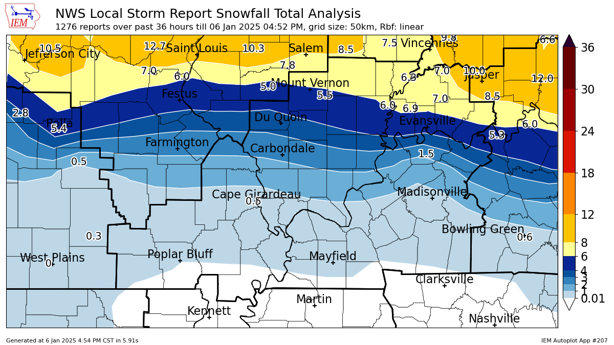
I measured 5.9" just north of Evansville BEFORE the freezing rain hit. Then we got sleet and ~.8" of freezing rain(ice) + some sleet. Then another ~1.3" of snow this morning. We live just north or Evansville.
So a total of 7.2" of snow and .8" of freezing rain/ice! There were higher snowfall totals in many places in the country from this storm but it appears that we had close to the most amount of freezing rain!
Many of these reports below did not include all of our 1-6-25 additional snow on the backside of the Winter storm.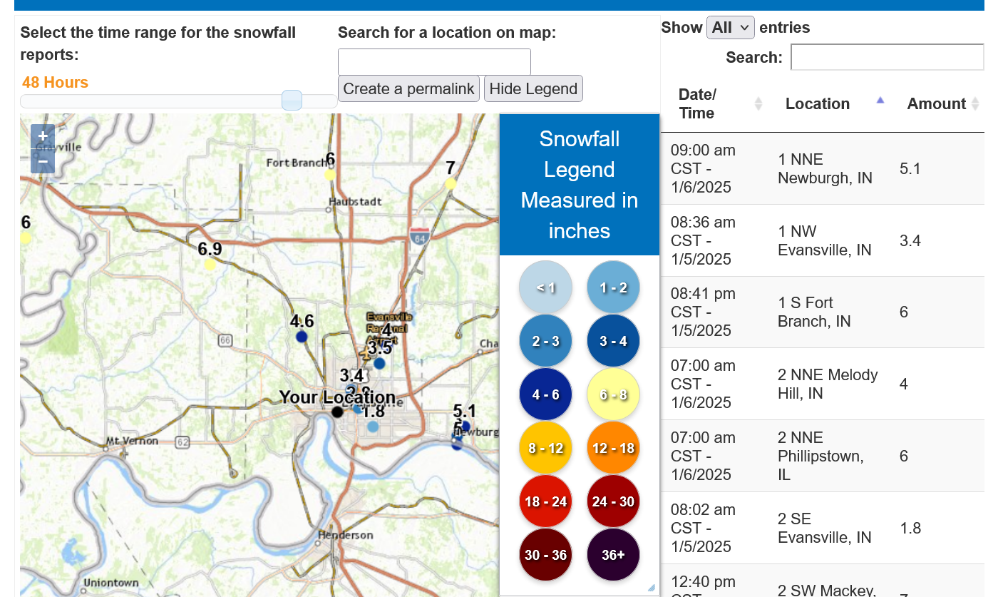
++++++++++++++++++++++
https://www.weather.gov/pah/2025January5WinterStorm
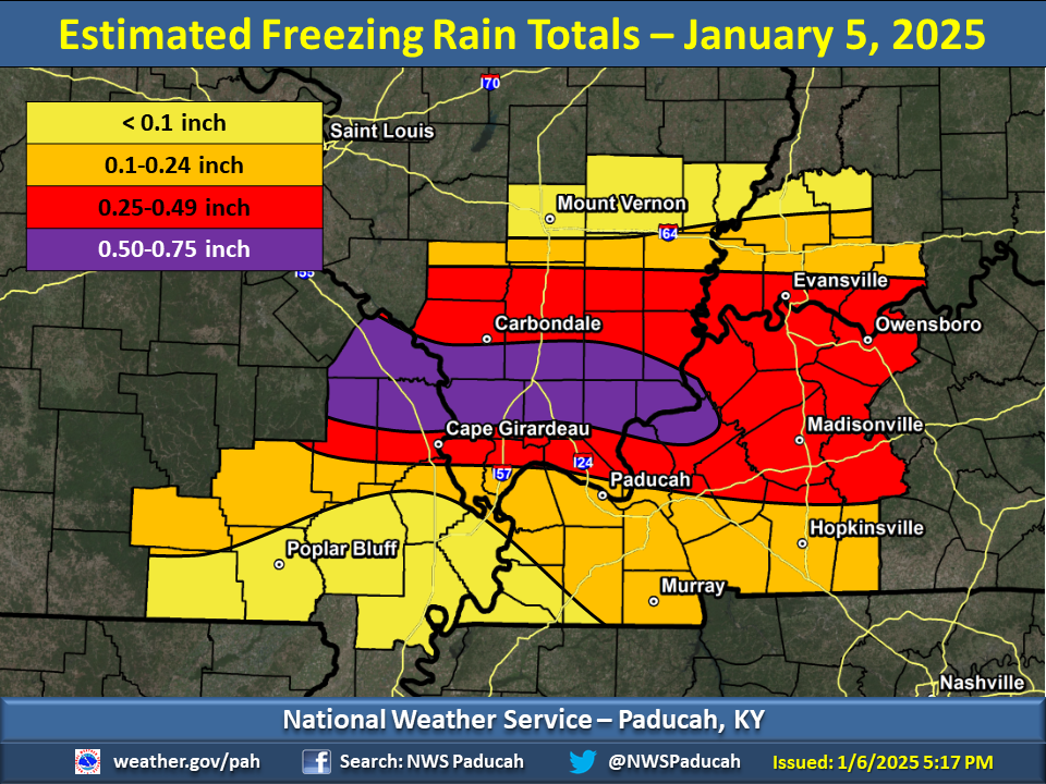
I would extend the purple color northeast to Evansville based on my measurements.