Previous Winter Storm threads:
Evansville Winter Storm 1-4-25+
https://www.marketforum.com/forum/topic/109322/
+++++++++++++
Midwest- Tracking the Winter Storm 1-4-25+
https://www.marketforum.com/forum/topic/109316/
+++++++++++++
Winter weather ahead 12-30-24
Started by metmike - Dec. 30, 2024, 10:04 p.m.
https://www.marketforum.com/forum/topic/109248/
+++++++++++++++++++
Note: I'm still tethering off of a cell phone to use the computer because our internet, cable and landline phone service from Spectrum is down. Thanks to our son, Quinn for showing me how to do this!
Our lives in 2025 are SOOO dependent on the recent technologies that couldn't have been imagined by old people like me many decades ago.
++++++++++++++
Get all the constantly updated weather here:
https://www.marketforum.com/forum/topic/83844/
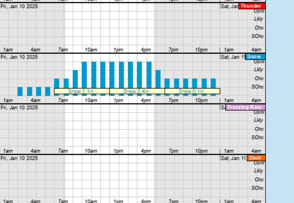
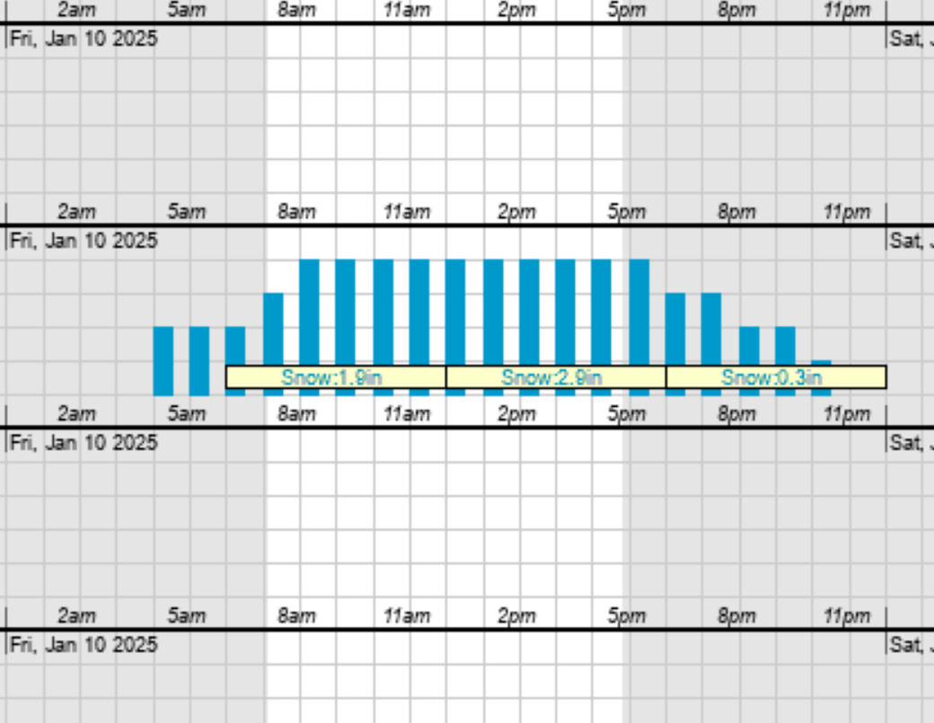
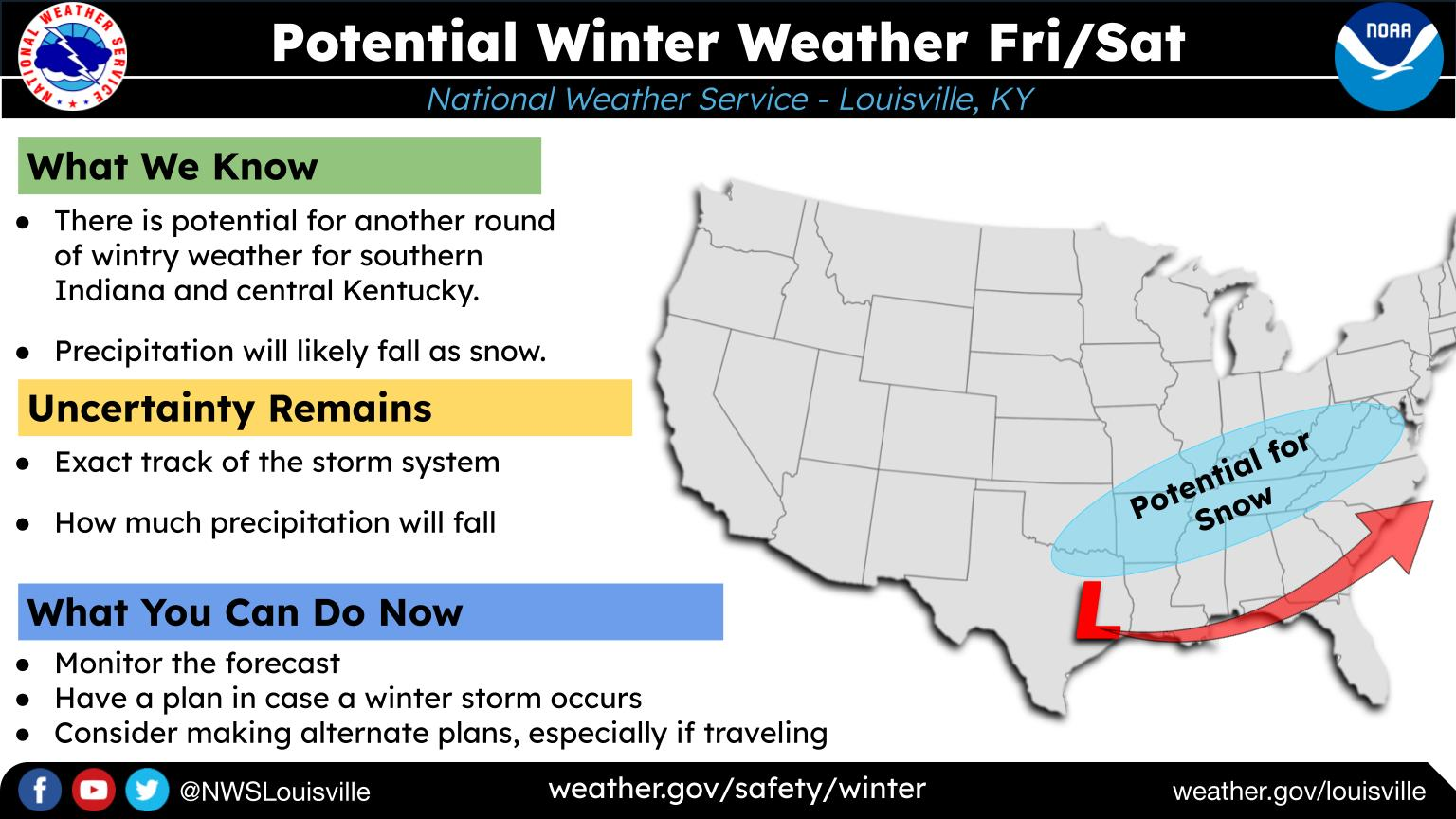
This one will track much farther south and be much weaker but possibly bring a couple inches of snow to Evansville.
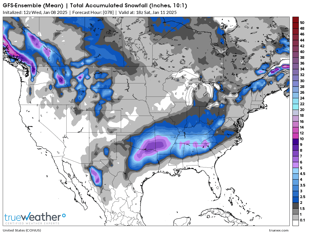
1. 18z GEFS(American model)
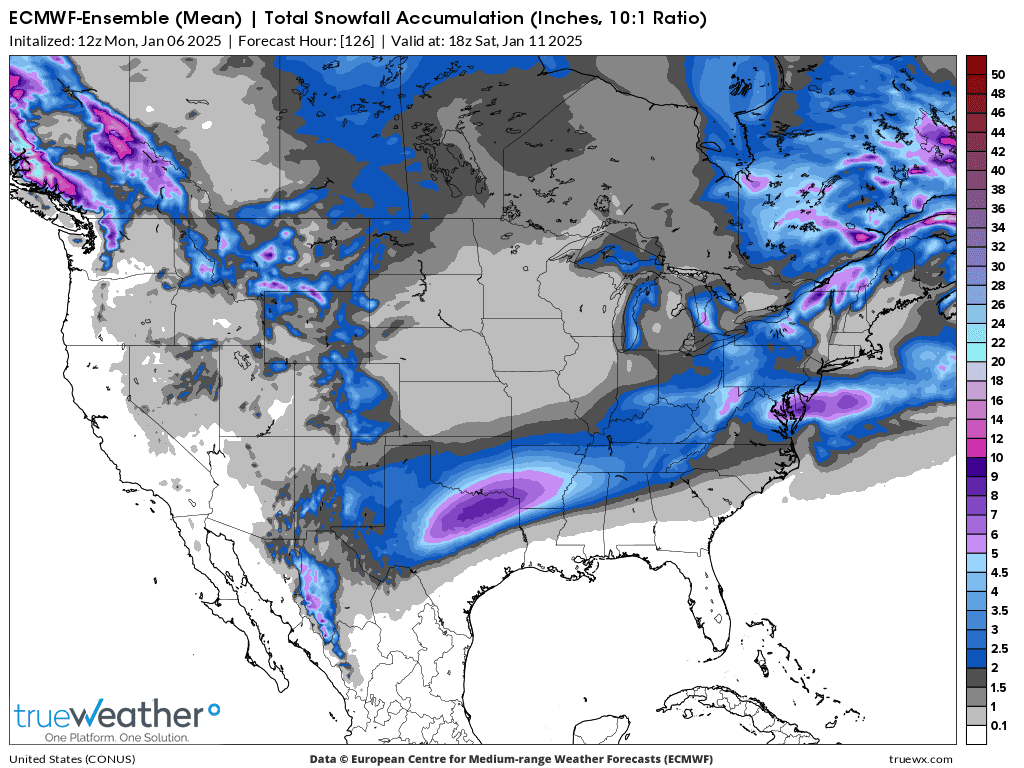
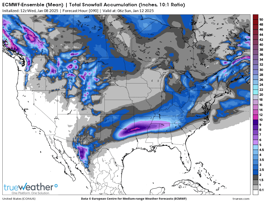
2. 12z European Ensemble
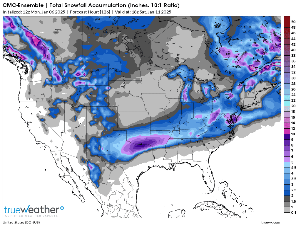
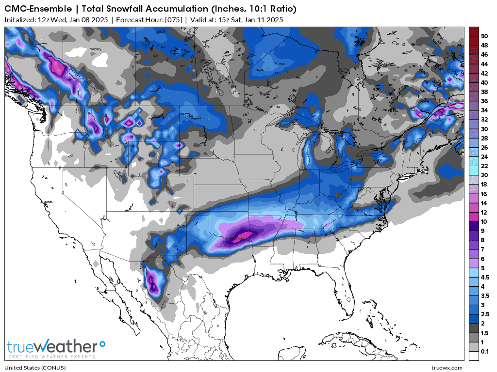
3. Canadian model
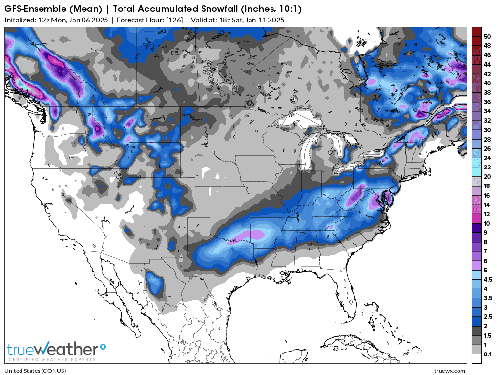
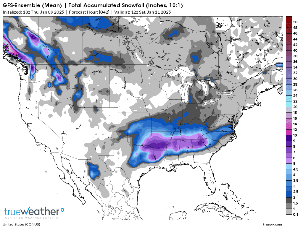
This was the snowfall total forecast from the just out 12z GEFS.
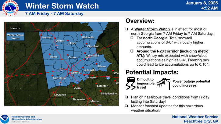
This one gets close to Larry who lives in the Atlanta, GA area!
Evansville? Mostly much farther south but maybe an inch of snow? Possibly 2+ inches?
Theres still a question of when our EVSC schools will reopen because of bad roads from this last storm.
If there’s 2 inches of snow possible on Friday, when the Thursday forecast comes out, there will not be school on Friday and our chess tournament will be cancelled at McCutchanville on Saturday. Likely rescheduled for January 18th, the following Saturday.
2.5 inches for Evansville on this model below.
Latest numerical guidance snowfall prediction for Friday/Saturday around 2 inches.
 +++++++++++++++
NWS messges:
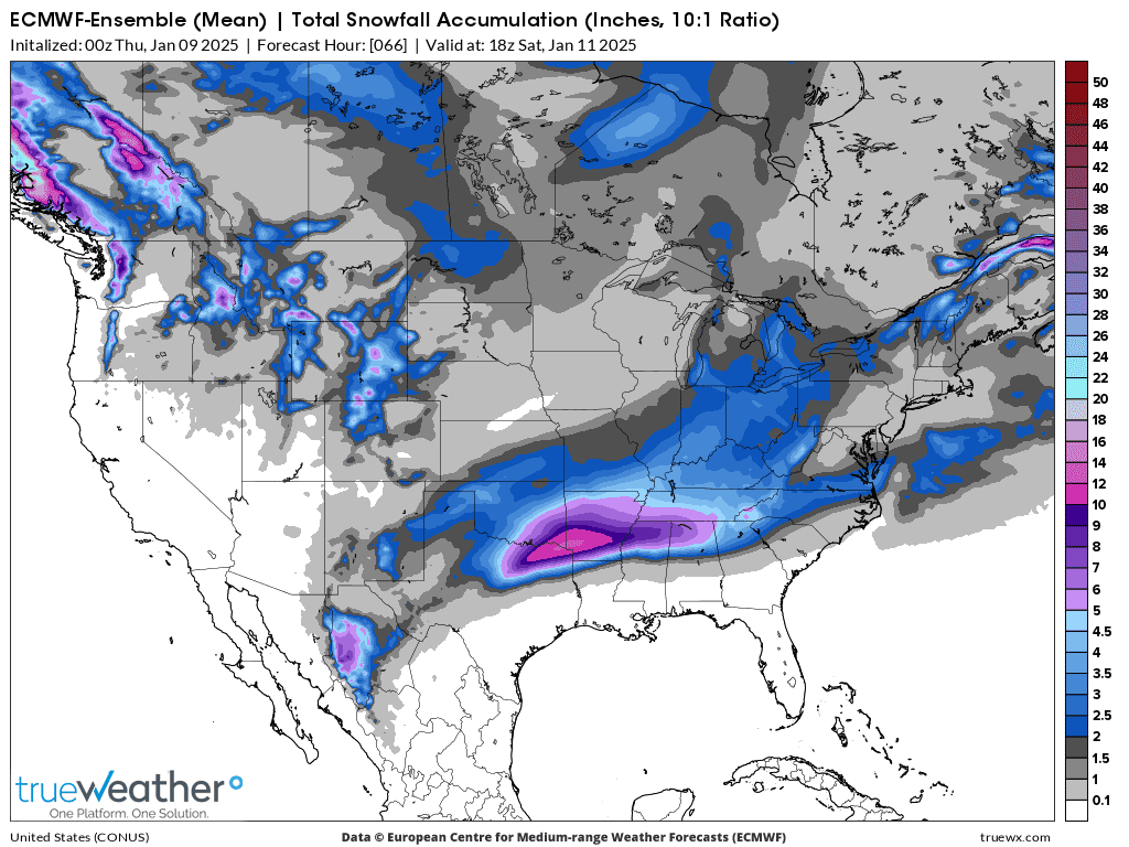
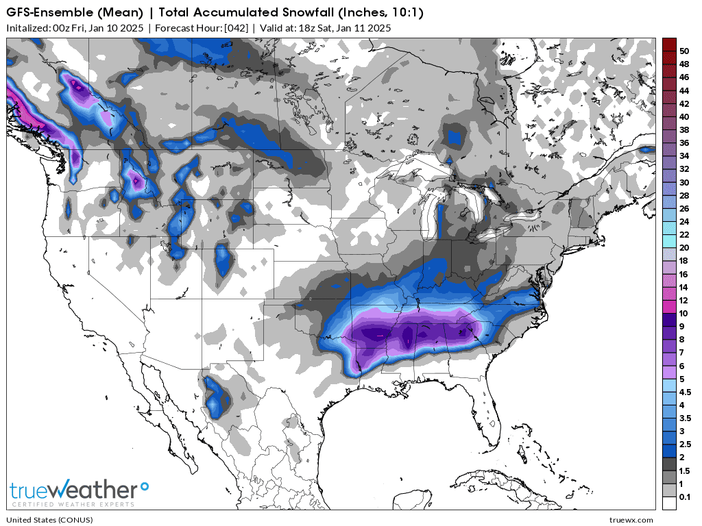
12z European model:
Just under 2.5 inches for Evansville.
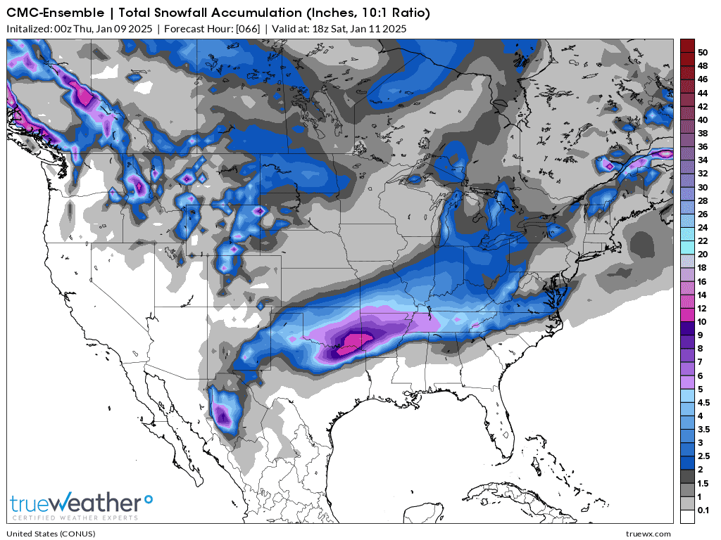
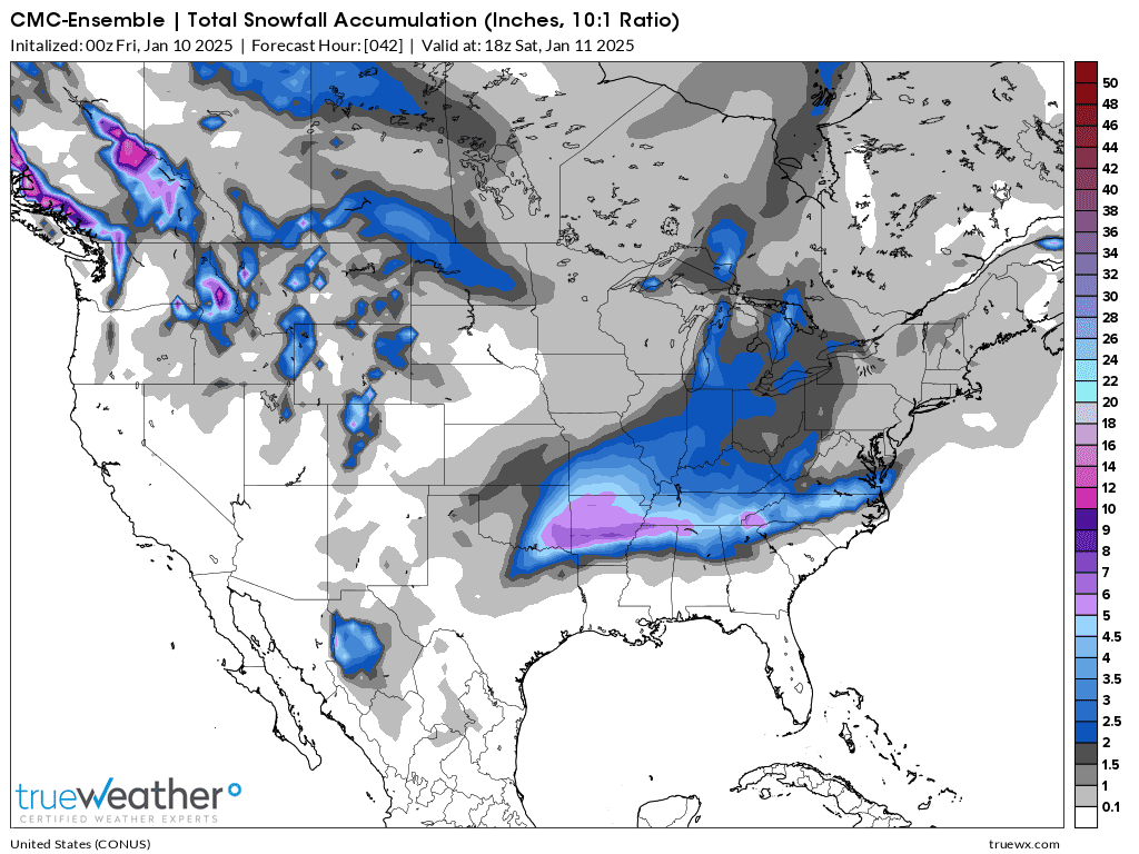
12z Canadian model:
Just over 2.5 inches for Evansville.
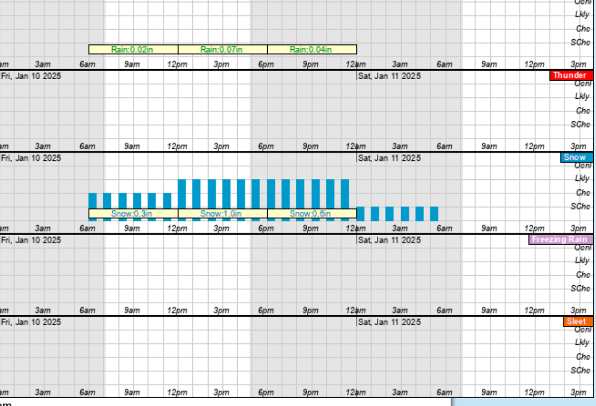
Still much uncertainty in amount of snow, so Evansville can still end up missing most of it, or getting several inches. It will all be very light, fluffy snow with no freezing rain and no sleet, no way.
Not a great deal of change, except for this next snow even getting closer, which is gradually increasing its likelyhood and the amounts in the forecast.
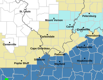
As a result, a Winter storm WATCH has been issued for a huge area of the South(pink is a Winter storm WARNING). Evansville in NOT included because we will likely see a weather advisory since the amounts of snow should be below the Winter Storm Warning criteria. The criteria for a Winter storm WATCH for just snow is usually 4+ inches (places farther south have a lower threshold because lower amounts of snow have a greater impact there).
It will all depends on the guidance when they issue the warning/advisories, probably later today.
Go to the link below, hit hazards box in the top right hand corner(it will also define all the color codes), if its not already in the hazards mode when you load the link.
Then you can hit any spot on the map, including where you live and it will go to that NWS with all the comprehensive local weather information for that/your county.


+++++++++++++++
Computer numerical guidance:
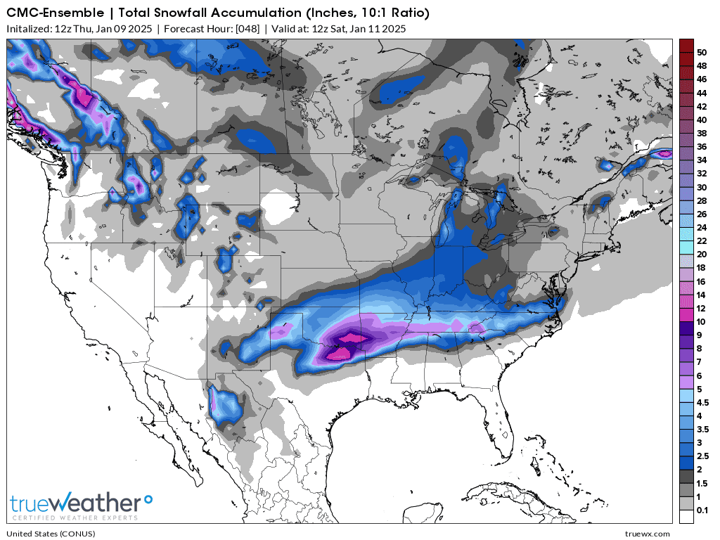
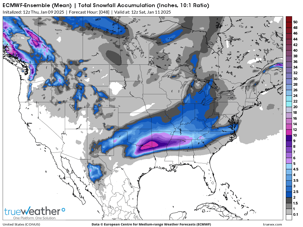
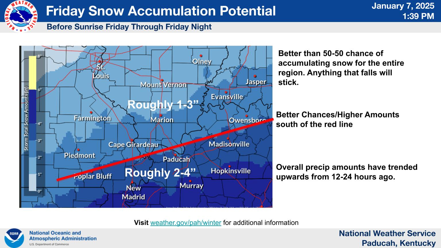
The latest models are still uncertain about how far north to take the accumulating snow. However, they all strongly agree on areas of HEAVY snow in the South, which rarely gets heavy snow, even though they don't agree on the amounts and exact locations. A band of 6+ inches will start in Northeast TX and extend east/northeast for a long distance.
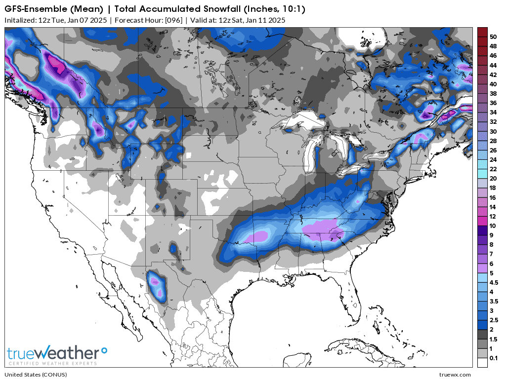
For Evansville below. If I had to pick an amount, I'd be leaning towards 2 inches right now. There will be no school on Friday, even with that lower amount. It's still possible to get LESS than that.
1. 0z Canadian model with the most snow = 4+inches.
2. 6z GEFS model with ~3 inches of snow
3. 0z European model with only ~2" of snow.
This just out, 12z GEFS model has the blue, 2" band pretty far north of us. It's still 48 hours before the first flakes land so there's a chance of missing most of that.........but those chances are rapidly diminishing! The NWS is extremely likely to issue a Winter weather advisory for Evansville in the next 24 hours for Friday and Friday Night.
The timing has moved up a bit to an earlier Friday Morning start, then ending by midnight. This is a no school Friday forecast.
Noon update: The Canadian model continues to have the highest snow totals in Evansville. 3"+ on this just out 12z run. Note that Evansville is well into the 3rd level of blue below.
1:30pm: The European model below has 2.5" in Evansville, so my confidence is increasing that we will have 2 inches of snow, despite there not being the greatest support from the weakish weather features involved this far north. I would be surprised to see a great deal more than that.
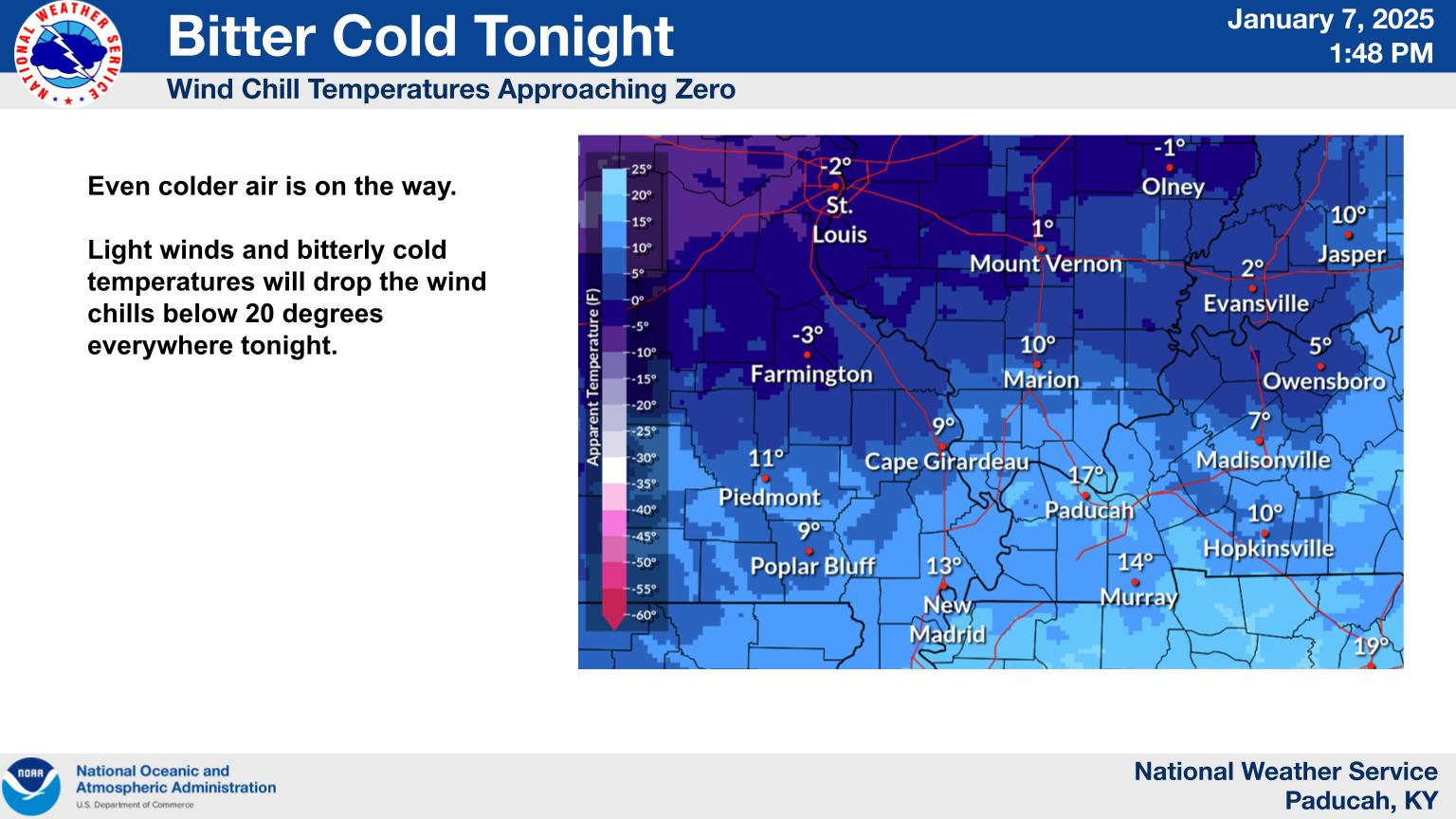
The NWS has issued a "cold weather advisory":
https://forecast.weather.gov/wwamap/wwatxtget.php?cwa=PAH&wwa=cold%20weather%20advisory
..COLD WEATHER ADVISORY IN EFFECT FROM 9 PM CST /10 PM EST/ THIS EVENING TO AM CST /7 AM EST/ THURSDAY...
* WHAT...Very cold temperatures as low as 2 below expected.
* WHERE...Portions of southern Illinois, southwest Indiana, and western Kentucky.
* WHEN...From 9 PM CST /10 PM EST/ this evening to 6 AM CST /7 AM EST/ Thursday.
* IMPACTS...Frostbite and hypothermia will occur if unprotected skin is exposed to these temperatures.
2:30pm The NWS has just updated the forecast to,add a winter weather advisory that includes Evansville for Friday for 2+ inches of snow. Use the link above to see that.
The EVSC just announced school will be closed again, tomorrow January 9th.
Considering the weather forecast for Friday, with 2 inches of snow falling during the day, there is a 90% chance of school being closed on the 10th too.
https://www.tristatehomepage.com/news/local-news/evsc-closed-on-january-9-2025/
Our scheduled chess tournament on January 11, 2025 is 90% likely to be rescheduled for January 18, 2025! We are good to go on that date!
The NWS has just made the expected update of a Winter weather advisory for Friday for 2+ inches of snow in Evansville.
95% chance that school will be cancelled again on Friday and our chess tournament will be january 18th Instead of the 11th.
The last 18z GEFS backed off on snow amounts a bit which is in line with my thinking this far north. I have a hard time going much over 2 inches and would not be surprised to see just an inch.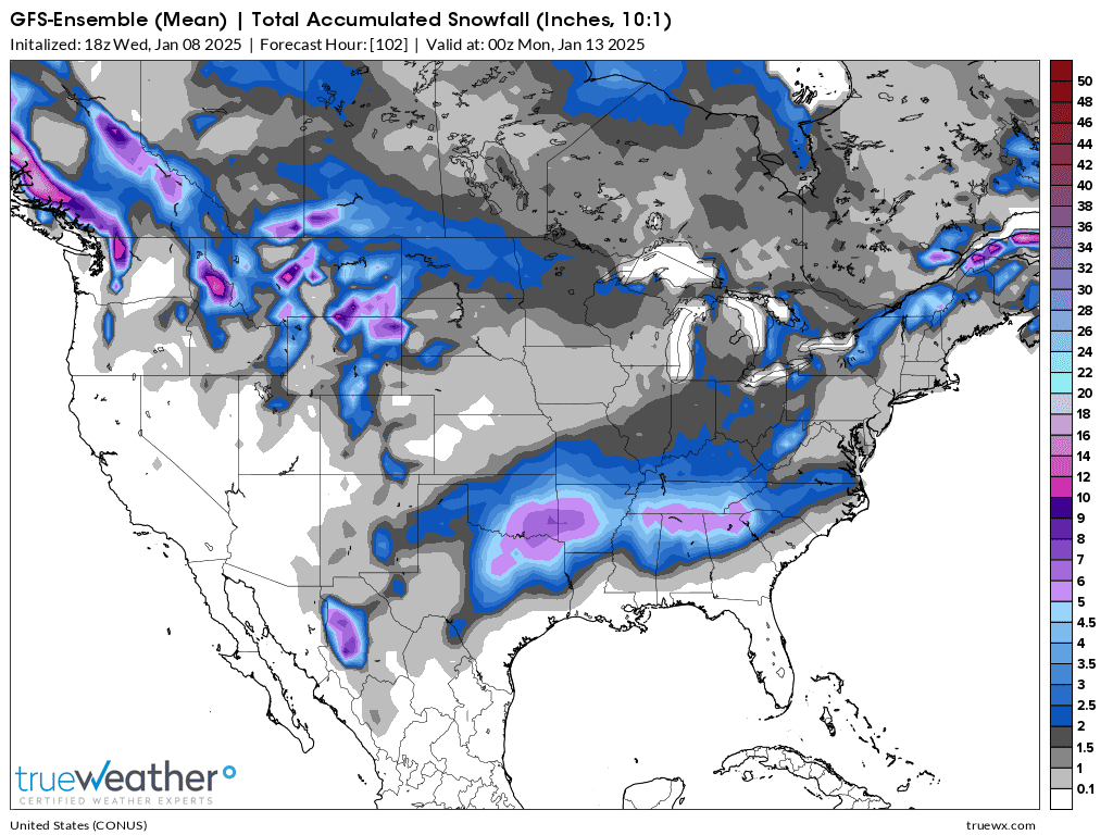
You can get all the Paducah forecasting office technical weather discussions/thoughts here: https://forecast.weather.gov/product.php?site=PAH&issuedby=PAH&product=AFD&format=CI&version=1&glossary=1
The European and especially Canadian models INCREASED the amounts of snow on their last 0z runs for Evansville and this has resulted in the weather advisory being upgraded to a winter storm WARNING for FRIDAY as seen in the pink on the map at the bottom.
The chance for school on Friday is now near 0% and our chess tournament in Evansville is rescheduled for January 18th.
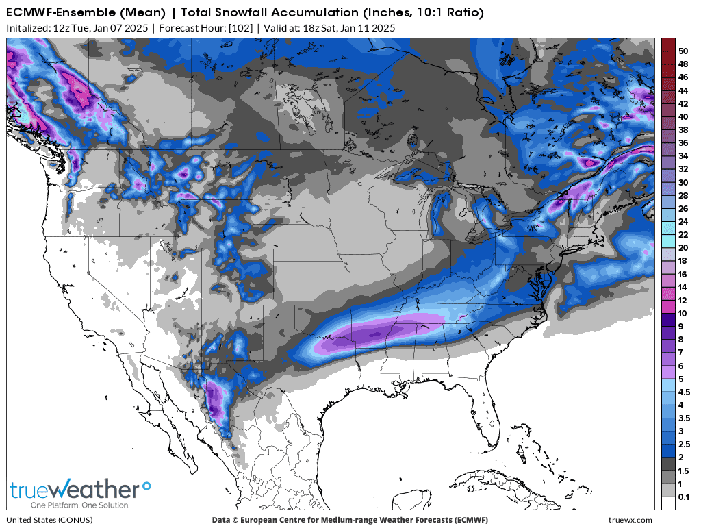
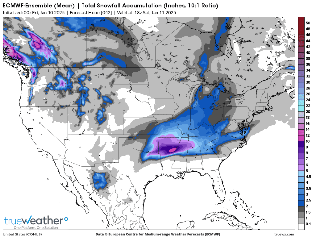
1. 0z European Ensemble snow forecast total: up to 3.5"
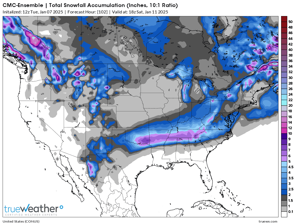
2. 0z Canadian Ensemble snow forecast: also 3.5"
Current Hazards at the link below.
Go to the link below, hit hazards box in the top right hand corner(it will also define all the color codes), if its not already in the hazards mode when you load the link.
Then you can hit any spot on the map, including where you live and it will go to that NWS with all the comprehensive local weather information for that/your county.
5am update: This was the just out 6z GEFS snow forecast: Just under 2.5".
I'm leaning with the lighter amounts. We should keep in mind that the snow/water equivalent will be on the high side because of the cold temps and fluffy type snow. 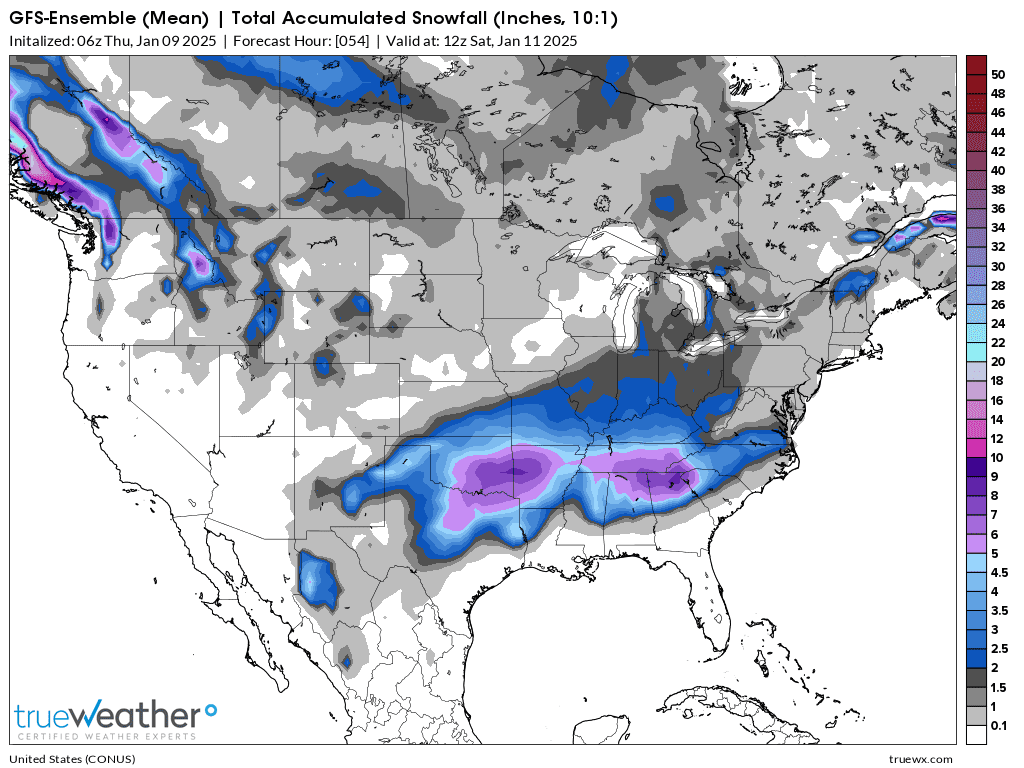
Because this snow will be falling at a slightly colder temperature than our last event, it will take less moisture to create an inch of snow than when temperatures are at 32 degrees.
Typically, we use .1 inches of water = 1 inch of snow which is close when temps are just below freezing. However, I've seen some very heavy/wet snows that were .2 inches of water = 1 inch of snow.
Contrast that to a snow that falls when the temperature is in the single digits when .1 inches of water = 4 inches of snow! Very fluffy/powdery.
ESTIMATING THE WATER EQUIVALENT OF SNOW
https://www.ncei.noaa.gov/sites/default/files/2021-09/Estimating_the_Water_Equivalent_of_Snow.pdf
+++++++++++++++++++++++
Latest computer generated snowfall prediction below = 3.6 inches. I lean towards less than that but alot of the guidance disagrees with me, so I might be wrong.
Being wrong for a living is the life of an operational meteorologist
https://forecast.weather.gov/MapClick.php?lat=38.05&lon=-87.53&unit=0&lg=english&FcstType=graphical
The storm is already hitting the far Southern Plains/Texas. You can track the radar images at this link. Unlike the previous storm, we won't see a well developed surface low this time.....or the strong winds from its circulation and the pressure gradient from it contrasting with an Arctic High to the north.
In fact, it's snowing right now under a surface ridge of high pressure.
https://www.wunderground.com/maps/radar/current


For us, this will be mostly driven by a very powerful, upper level jet stream. Not much lower levels or moisture available. This is the forecast for Friday afternoon at 300 mb, which is around 28,000 feet up at this time of year.

Red = 150+ knots = almost 200 mph! If this were a Spring Storm and we were in warm, humid air, this would cause a major, severe storm/tornado outbreak!!!
++++++++++++++
| THE 300 / 200 MB CHART |
https://www.weather.gov/source/zhu/ZHU_Training_Page/winds/JetStream_Stuff/300_200_chart.htm
METEOROLOGIST JEFF HABY
Latest 12z models featured the snowiest, Canadian model dropping snow amounts from 3.5 to 2.5 inches which is moving in the direction I thought it would(even though I might be wrong).
The NWS does a wonderful job and none of us would have all this information without them, however our current Winter Storm Warning SHOULD BE a Winter Weather Advisory based on THEIR criteria/threshold which is 4 inches of snow for pure snow events. Maybe they will adjust it later today.
You can get their latest discussions from the Paducah office here. They are usually very insightful!
++++++++++++++++
Added 1:30pm: The 12z European ensemble model has 3.5 inches of snow:
It's official as of 6 minutes ago!
https://www.wevv.com/weather/closings/
| UPDATED THURSDAY, JAN 9 AT 12:39 PM |
SCHOOLS |
| Indiana |
| Evansville Catholic Schools: Closed Tomorrow |
| Evansville-Vanderburgh Schools [WEB]: Closed Tomorrow |
| Warrick County Schools [WEB]: Closed Today and Tomorrow |
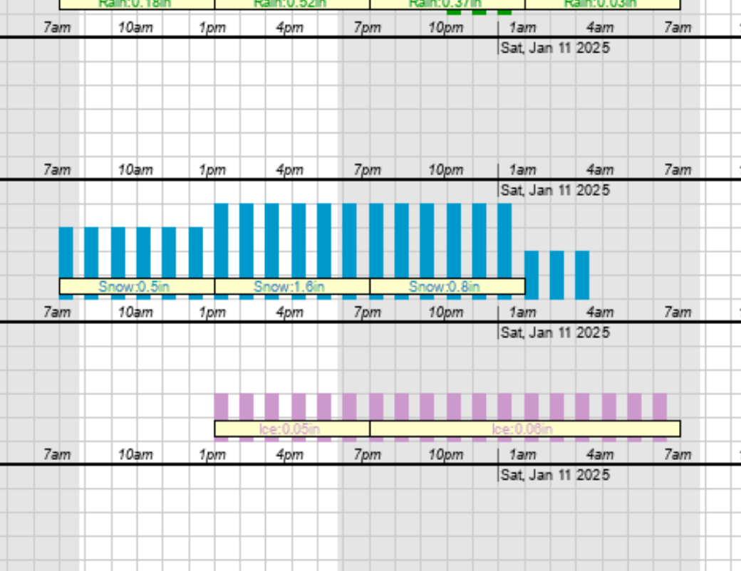
The updated NWS for Evansville has 4-7 inches of total snow. Wow! That seems like too much for this system to me but there is a powerful jet stream and upper level support and the water/snow ratio is going to be 14:1 so just .4 of water equivalent can make 5.6 inches of snow.
Here's their forecast discussion:
Latest computer numbers: 5.1 inches. That seems like too much snow to me too.
The last 18z GEFS took out snow. I've been wrong plenty of times before and need another run like this to be more confident but this helps boost my confidence that the going snow forecasts from other sources right now are too high.
NWS=4-7 inches total
Wayne Hart on WEHT=3-5 inches.
Wayne, by the way is the best tv meteorologist that I know of in the country, currently on the air. Tom Skilling from Chicago was my favorite for decades. In September 1993, news director Lloyd Winnecke (later the Evansville Mayor Winnecke) replaced me at WEHT with Wayne. I was there from 1982-93.
https://www.youtube.com/watch?v=-w7_CLn8QSs
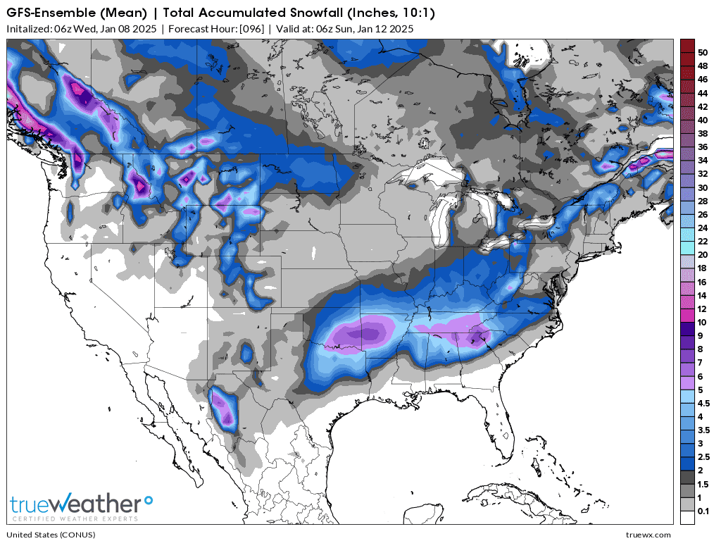
0z GEFS now out: Heavy snows in the South where snows of this magnitude, 6+ inches( a few spots could hit 10 inches) are pretty unusual.
I'm still not that impressed with amounts in Indiana. However, the GEFS has had the lowest totals all week. Let's see what the other 0z models show.
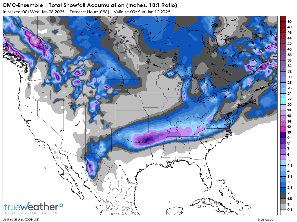
1. 0z Canadian Ensemble model: 2-3 inches across Indiana
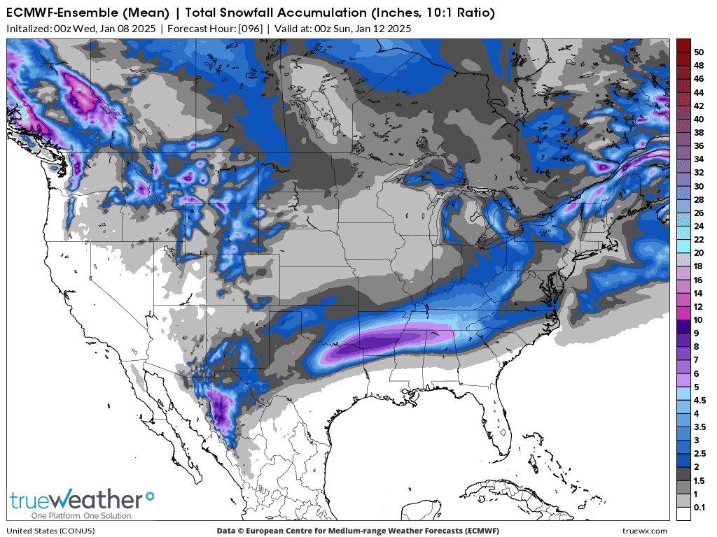
2. 0z European Ensemble model: 3-5 inches (being generous) across Indiana.
Highest amount in the far southwest
The time stamps at the top of these posts are in Eastern Time!
A few bands of some heavier snow approaching from the southwest that will last for a few hours, then taper off.
https://www.wunderground.com/maps/radar/current


+++++++++++++++++++++++++
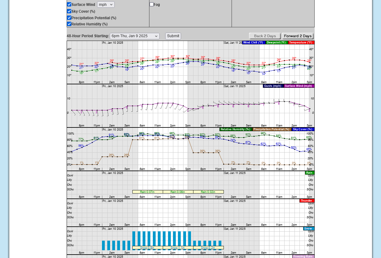
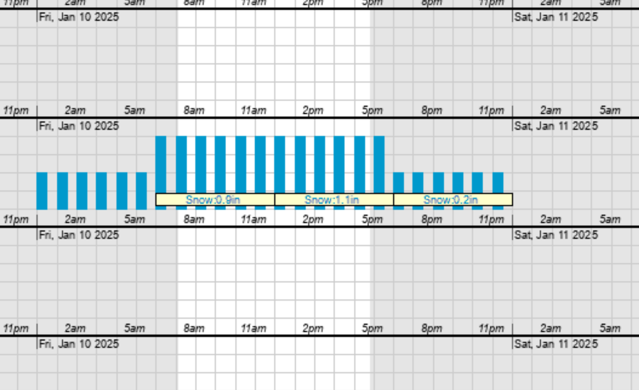
9:56 am: So far, I've had close to 1.5 inches of snow.
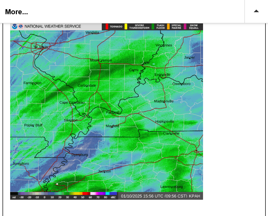
The heavier band has set up west/northwest of Evansville, especially in southern IL(moving northeast towards Vincennes)!
A northeast moving dry slot is noted in western TN, nosing into far southwest KY that could shut the snow down early this afternoon along its path.
The top image below is a freeze frame at 9:56 am. The live radar is at the bottom.
+++++++++++++++
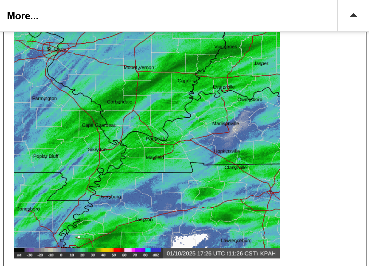
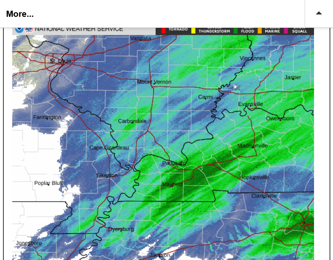
11:26 AM: Below, Several dry slots in KY and TN TOP THE SOUTH, where the highest snow totals are predicted and the heaviest band of snow is farther to the northwest, in IL to southwest IN, where less snow was predicted. Maybe some heavier bands will still hit Evansville this afternoon?
Unusual jet stream dynamics are controlling the magnitude of the snow right now instead of the surface features that are often the key.
+++++++++++
Live radar below:
The heavier snow bands FARTHER NORTH from the surface low/storm are being caused by the lift of the left/front quadrant of a very powerful jet stream:
Re: Re: Re: New Winter Storm 1-6-25+
By metmike - Jan. 9, 2025, 12:19 p.m.
For us, this will be mostly driven by a very powerful, upper level jet stream. Not much lower levels or moisture available. This is the forecast for Friday afternoon at 300 mb, which is around 28,000 feet up at this time of year.
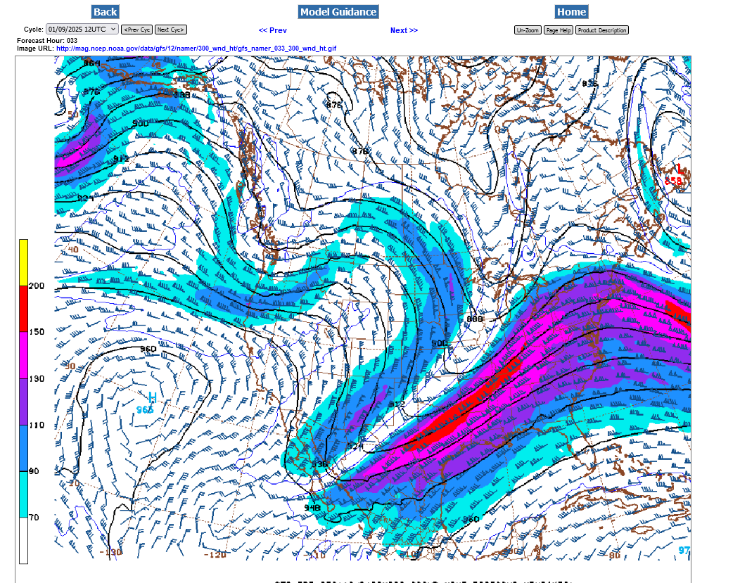
Red = 150+ knots = almost 200 mph! If this were a Spring Storm and we were in warm, humid air, this would cause a major, severe storm/tornado outbreak!!!
++++++++++++++++
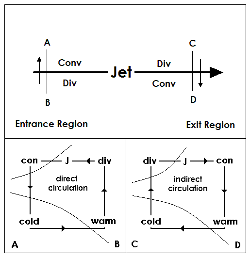
HABYTIME MINI LECTURE 26:
QUADRANTING A JET STREAK
http://theweatherprediction.com/habyhints2/601/
https://wxonline.info/topics/jetstream.html
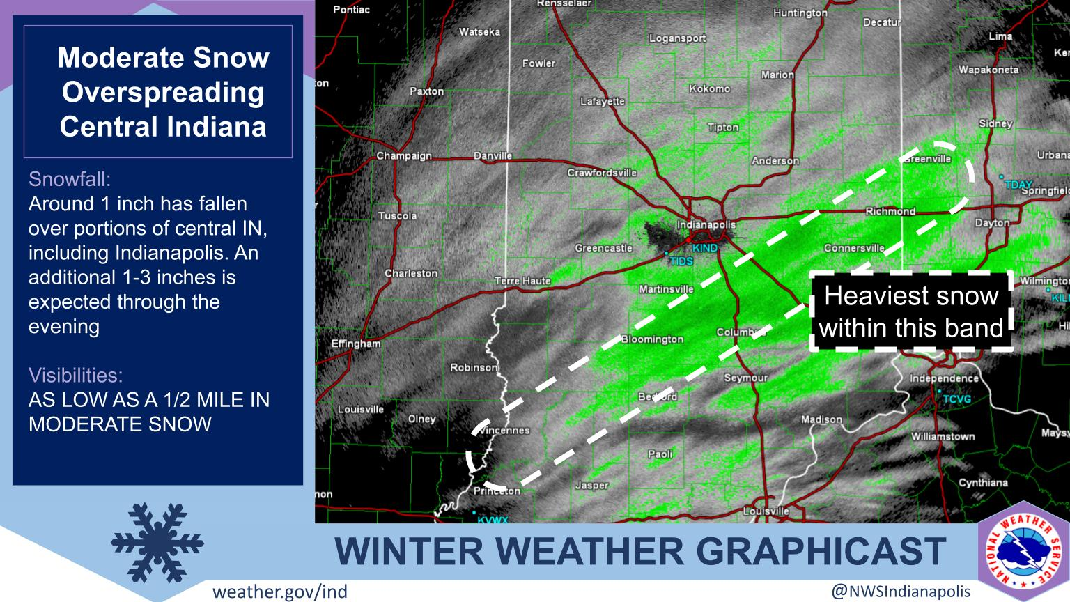
metmike: Currently, we are in region C below on the left side in front of the strongest upper level winds which are being maximized to our northwest, VERY FAR NORTH/AWAY from the surface low. This causes divergence aloft which pulls up/lifts the air below, resulting in instability from the rising air. This is causing the heaviest snow bands to be northwest of Evansville at the moment.
There will be a test on this at chess practice next week(just kidding).
I'm at almost 2 inches of snow total so far outside. Maybe another 2 inches to go? If we get under the heavy snow bands a bit more. If not a bit less.
Indianapolis has also been tracking this heavy snow band as it tracked farther northeast this afternoon.
This was just after I was making comments in the previous post.
https://www.weather.gov/ind/weatherstory
A new heavy snow band, this time to our south.
The back edge of the snow can be seen on the far left at 2:32pm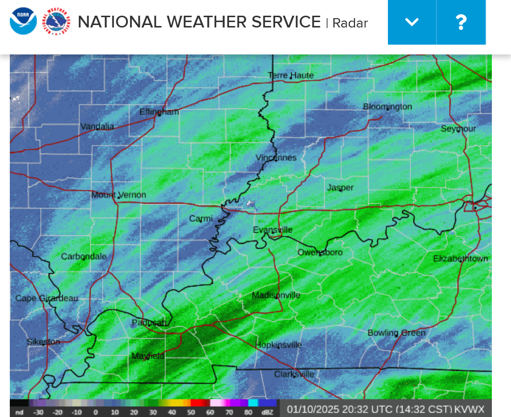
Live radar below:
Less than an inch to go!
Ending on the EARLY side of this NWS graphic. That's when its time to remove the snow on your sidewalk, driveway and other areas covered in snow that need to go(for the last time with this event)!
This one will be a piece of cake compared to earlier in the week.
https://www.weather.gov/pah/weatherstory
Live radar below:
Our bird feeders have had close to 100 birds on and below them this afternoon at one time........and several squirrels.
I'm going to need to refill them again and just did that a couple of days ago. I have another 40 lb bag, which would normally last awhile but this weather is causing a huge increase in their need for food to survive.
`They adjusted the ending times based on the radar trends mentioned earlier. These times match up with the radar better than the previous ones.
Who's ready to shovel more snow??? Yeah! let's get some more exercise!!!

Let's have some snow shoveling music!
https://www.youtube.com/watch?v=u0yqbAlhf5Y
++++++++
https://www.youtube.com/watch?v=L8ZisEVmfMk
+++++++
I Love Shoveling The Snow | Songs From Caitie's Classroom | Fun Winter Song for Kids
https://www.youtube.com/watch?v=QQ2iFpmWaLs
++++++++++
the projected snow ending times busted real bad from every source, especially me, who had the earliest time of all in the lasts posts above.
What happened is that all the northeast moving snow bands cleared us after the system passed by us and the snow ended for a brief period.
Then, on the backside, we had another 2 hours of extremely light snow that came back down on us from the north., accumulating another dusting of snow……after having shoveled, this stunk and required going over it again, before putting melting chemicals on as the last action.
Sorry about that!!
If we get a few hours of sunshine today, that should melt away any residual snow from that late dusting or refrozen moisture.
The key to keeping things safe the next numerous days will be to retreat melted runoff areas every evening so they dont refreeze on your walkways and driveways.
Sunday will actually crack freezing by a few degrees but there’s a lot of below to much below freezing time coming up the next 2 weeks, so the snow and ice will still be there, very slowly eroding, melting a bit during the day, then refreezing at night. This means returning new slick spots in the evening for some of us.
There will also be a great deal of sublimation going on.
Whats sublimation??
More on that in the next post!
As well as a recap of where all the snow and ice is around the country. This is the most coverage on the ground in years, especially in the south.
We ended up with 4 inches of snow total, which was a bit more than I thought would fall.
the heaviest snow was originally expected to occur south of Evansville but surprise, surprise! As we showed in the middle of the event, above with radar returns,,,,a band of much heavier snow developed to our northwest and dumped up to 7 inches of snow Northwest of Evansville!
This is why I will often joke that an operational meteorologist IS WRONG FOR A LIVING :-)
But seriously, even with the incredible technology and advancements which have greatly improved our skill at forecasting weather, especially at longer times frames, we will continue to bust badly on some forecasts, in some realms.
it helps to keep a person humble and to remember, like in chess, the most important move is often what your opponent did last and how you respond to that!
In life, the faster you react to adjust a plan that’s failing, the better off you are with a new and improved plan. You can quickly turn lemons into lemonade by adjusting a bad plan to a better one.
in commodity trading, it means not getting married to a losing,position. A small loss is reason to celebrate when the last thing you did prevented it from turning into a huge loss.
A bad weather forecast can be adjusted to account for something called "Now-casting" which dials in the latest information of an ongoing, dynamic weather situation.
We all make mistakes or miscalculate or have wrong expectations and let our cognitive bias take us in the wrong direction initially.
This is extremely fixable by a person with an open mind that sees authentic, objective facts……especially those that contradict what we want to see from preconceived notions.
In politics in today's world this is virtually impossible for many,people that align strongly with one side.
However, in science, biology, physics, nature , chess, commodity trading and many other realms there is only 1 truth based on indisputable laws that don’t care what party you are from.
When you let politics steer you against the objective truths, bad things happen. Again, this is always fixable but only with a humble, open mindset that uses mistakes to learn instead of finding excuses to justify them!
Easy to say or type on a keyboard at a forum. Hard to apply in the real world for all of us but easier and easier each time we do it with purposeful discipline.
We can cause ourselves to replace bad habits with good habits over time!
What kind of weather thread is this anyway☃️
just trying to shine a little☀️ out there
https://en.wikipedia.org/wiki/Nowcasting_(meteorology)
Nowcasting is weather forecasting on a very short term mesoscale period of up to 2 hours, according to the World Meteorological Organization, and up to six hours, according to other authors in the field.[1][2] This forecast is an extrapolation in time of known weather parameters, including those obtained by means of remote sensing, using techniques that take into account a possible evolution of the air mass. This type of forecast therefore includes details that cannot be solved by numerical weather prediction (NWP) models running over longer forecast periods.
Nowcasting in meteorology uses surface weather station data, wind profiler data, and any other weather data available to initialize the current weather situation and forecast by extrapolation for a period of 0 to 6 hours. In this time range it is possible to forecast small features such as individual storms with reasonable accuracy. Weather radar echoes and satellite data, giving cloud coverage, are particularly important in nowcasting because they are very detailed and pick out the size, shape, intensity, speed and direction of movement of individual features of weather on a continuous basis and a vastly better resolution than surface weather stations.[3]
This used to be a simple extrapolation by a forecaster for the following few hours.[3] But with the development of mesoscale numerical weather models, these information can be ingested into an expert system to produce a much better forecast combining numerical weather prediction and local effects not normally possible to be known beforehand. Different research groups, public and private, have developed such programs.
metmike: Ever notice how snow/ice will disappear from the ground, your car and other exposed surfaces, even when the temperature remains below freezing and there is no melting?
There can be some settling and compacting of course but we are referring to SUBLIMATION!
This is when Frozen water\H2O(ice/snow) goes directly from the frozen state to the gaseous state WITHOUT melting. Without passing thru the liquid state.
Dry ice(frozen carbon dioxide) does the exact same thing but the sublimation point is colder than any temperature on the planet. So all the CO2 in the atmosphere is a gas.
We will NEVER see liquid CO2 unless its under extremely high pressure inside some sort of pressurized vessel.
H2O goes thru all of its phase changes easily with the pressure of 1 atmosphere at the surface of our planet. At 1 atmosphere, temperature is the key determinant of the phases between solid, liquid and gas. 32 and 212 degrees F (0 and 100 C) take us from solid to liquid to gas. However, sublimation takes us from solid to gas.
Bottom line is that we have a great deal of snow/ice out there after our 2 recent Winter storms and temperatures will remain below freezing much of the time the next 2 weeks. During that time, some of it will SUBLIME away, at times when the temperature is below freezing. The key factors in determining the rate of sublimation are:
1. Temperature-the closer to freezing, the greater the sublimation rate
2. Wind-the stronger the wind, the greater the sublimation rate
3. Humidity-the lower the humidity/dew point, the greater the sublimation rate
4. Sunshine-heat energy from the sun will increase sublimation
++++++++++++
https://en.wikipedia.org/wiki/Sublimation_(phase_transition)
Sublimation is the transition of a substance directly from the solid to the gas state, without passing through the liquid state.[1] The verb form of sublimation is sublime, or less preferably, sublimate.[2] Sublimate also refers to the product obtained by sublimation.[2][3] The point at which sublimation occurs rapidly (for further details, see below) is called critical sublimation point, or simply sublimation point. Notable examples include sublimation of dry ice at room temperature and atmospheric pressure, and that of solid iodine with heating.
The reverse process of sublimation is deposition (also called desublimation), in which a substance passes directly from a gas to a solid phase, without passing through the liquid state.[4]
Technically, all solids may sublime, though most sublime at extremely low rates that are hardly detectable under usual conditions. At normal pressures, most chemical compounds and elements possess three different states at different temperatures. In these cases, the transition from the solid to the gas state requires an intermediate liquid state. The pressure referred to is the partial pressure of the substance, not the total (e.g. atmospheric) pressure of the entire system. Thus, any solid can sublime if its vapour pressure is higher than the surrounding partial pressure of the same substance, and in some cases, sublimation occurs at an appreciable rate (e.g. water ice just below 0 °C).
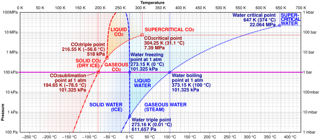
Comparison of phase diagrams of carbon dioxide (red) and water (blue) showing the carbon dioxide sublimation point (middle-left) at 1 atmosphere. As dry ice is heated, it crosses this point along the bold horizontal line from the solid phase directly into the gaseous phase. Water, on the other hand, passes through a liquid phase at 1 atmosphere.
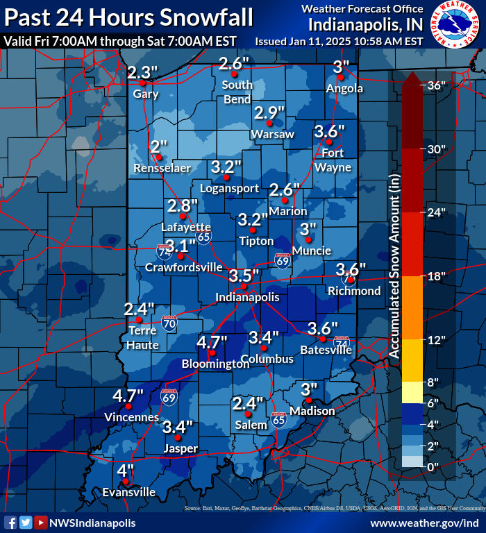
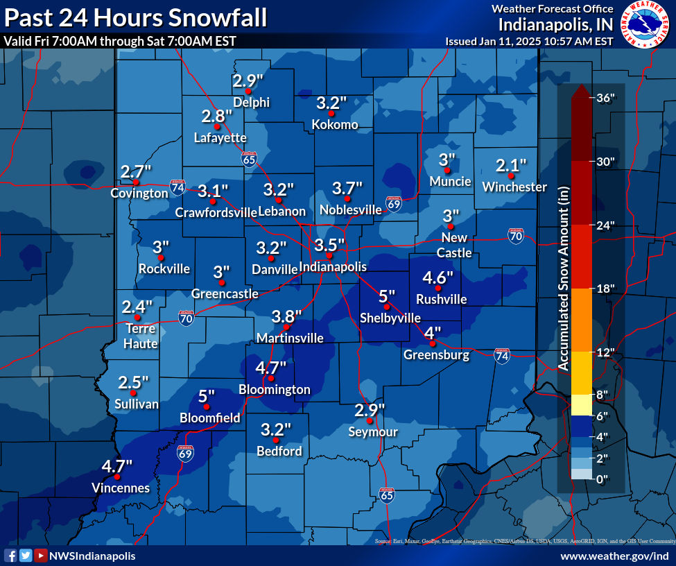
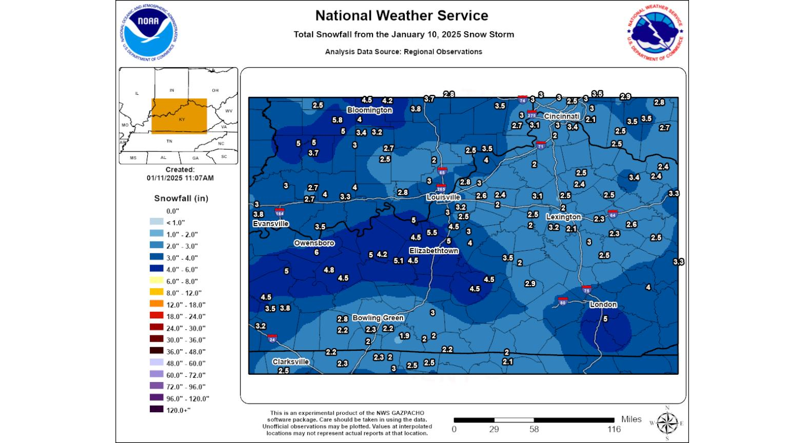
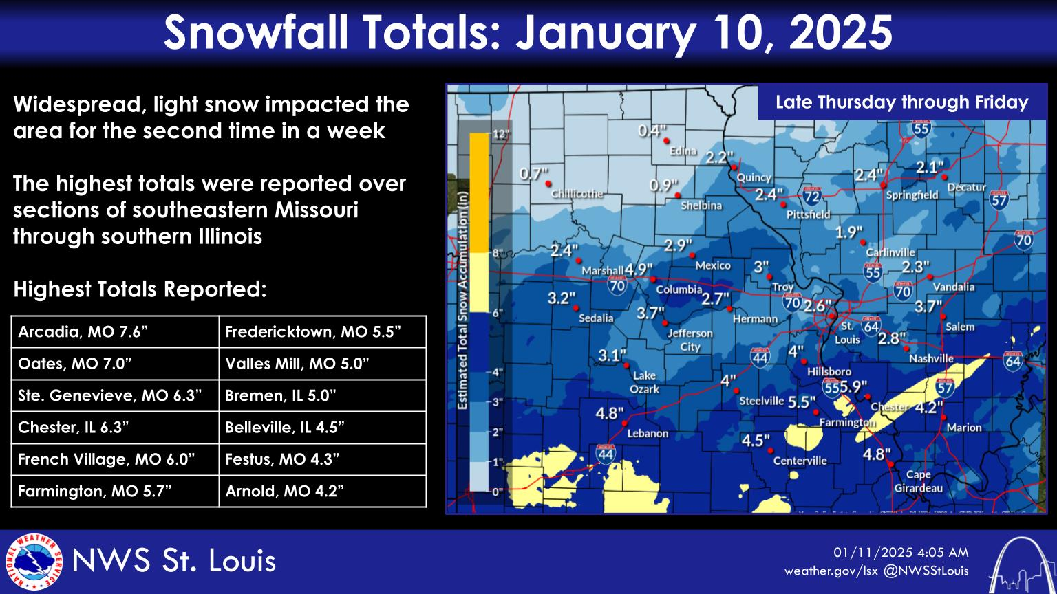
We got a wonderful summary of snow amounts from the NWS in Louisville, NWS in Indianapolis and the NWS in St. Louis.
From Indianapolis: Evansville got 4.0 inches which is a tad over what I measured.
Total reports: https://www.weather.gov/ind/jan102025snow
From Indy: Zoomed in a bit more:
From Louisville: Evansville got 3.8 inches. Heavier amounts to our southeast and northeast on this map.
https://www.weather.gov/lmk/weatherstory
From St. Louis:
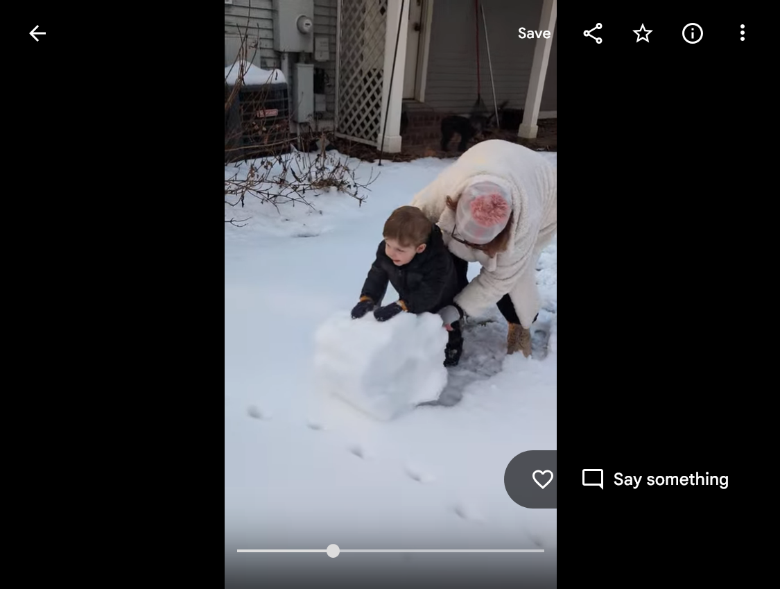
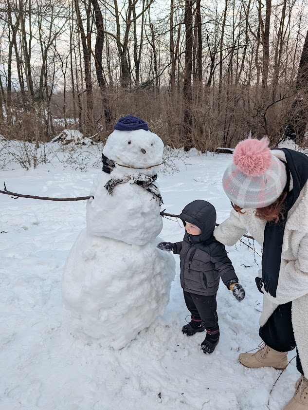
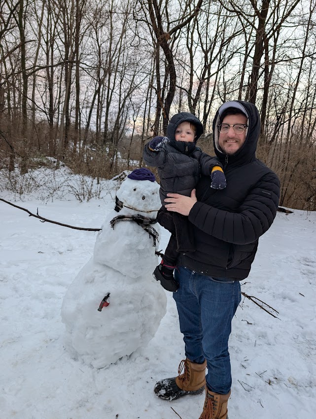
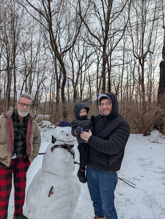
With the temperature getting above freezing on Sunday and making the top layer of snow perfect for packing, we made our 2 year old grandson, Cyrus's first snowman!
1 & 2. Cyrus and Grandma(Deb).
3. Cyrus and Daddy(Quinn)
4. Grandpa(Mike), Daddy and Cyrus

 Weather Map