++++++++++++++++++++++
++++++++++++++++++++++++++
Much of the country is getting hit with Bitter Cold!!!
Current Hazards at the link below.
Go to the link below, hit hazards box in the top right hand corner(it will also define all the color codes), if its not already in the hazards mode when you load the link.
Then you can hit any spot on the map, including where you live and it will go to that NWS with all the comprehensive local weather information for that/your county.

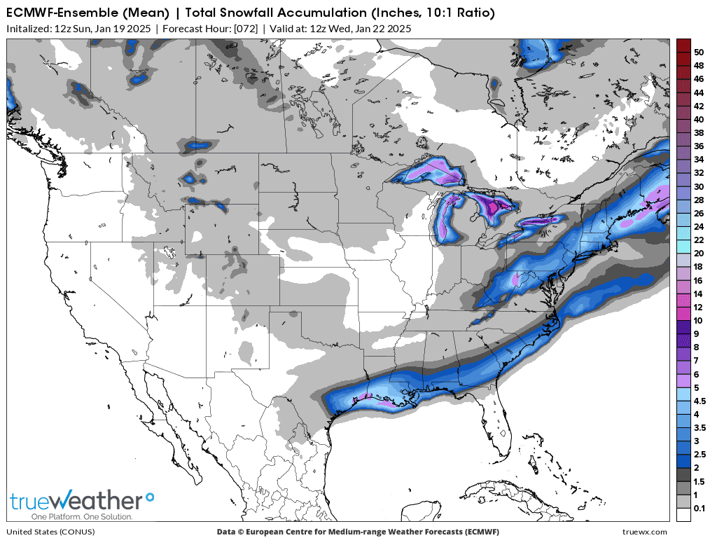
Total snow from the last 12z European model ensemble. Extremely rare heavy snow along the Gulf Coast. No, it's not from global warming!
++++++++++++++++
Upper level maps below.
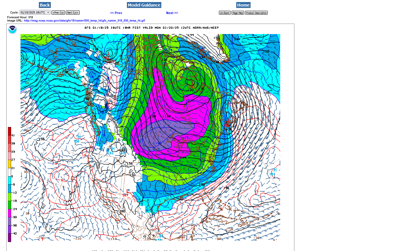
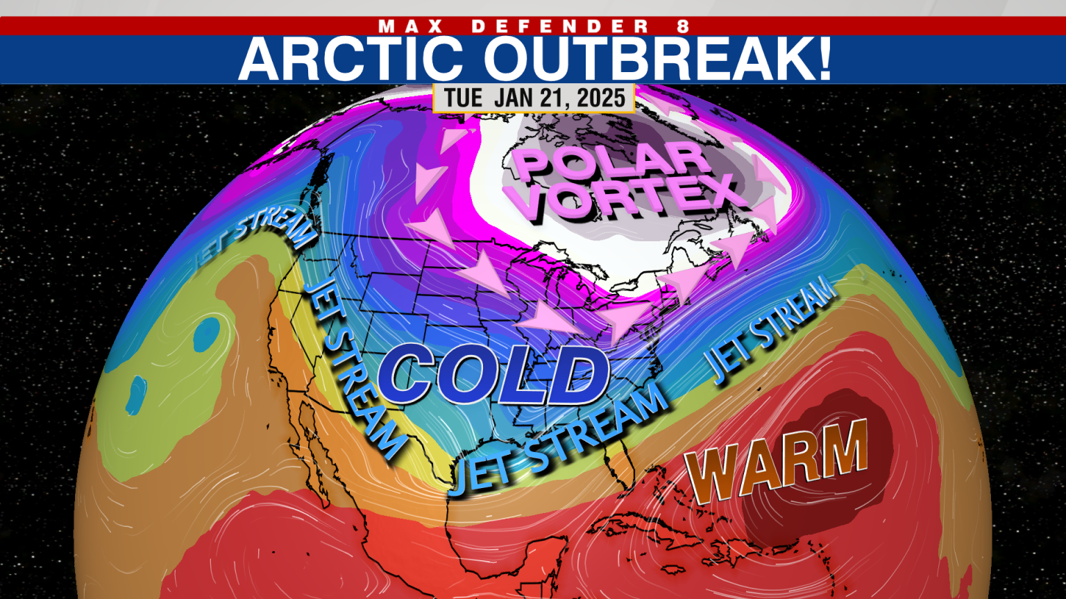
1. 250 mb = ~34,000 feet =Strongest jet stream. Polar Vortex centered over the southern Hudson Bay with a deep trough extending to far northern Mexico. Red color is a jet streak isotach 150+ knots, which is close to 200 mph! This air mass originated over Siberia, crossed all of Canada and all of the US and is surging south of the Gulf Coast.
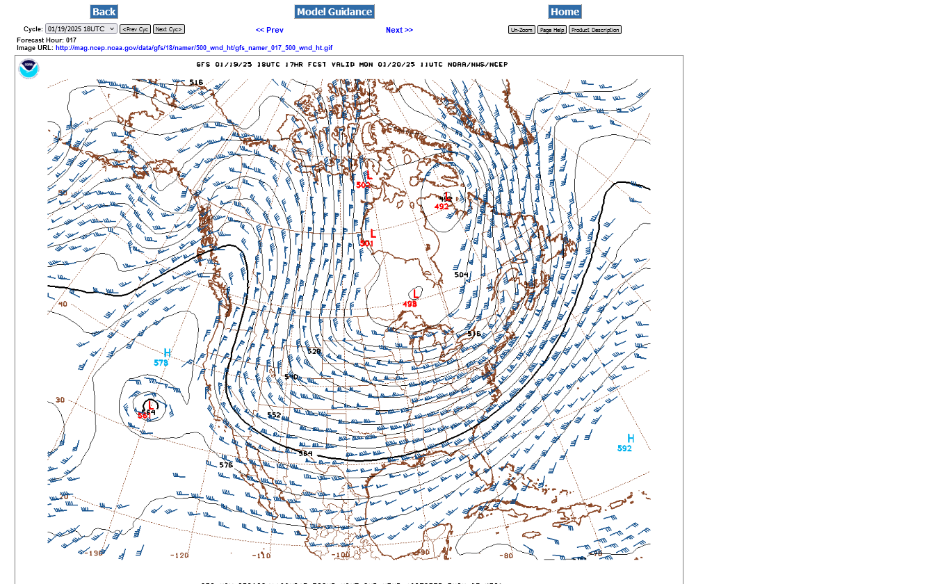
2. 500 mb = ~17,000 feet = Middle of the atmosphere. Polar vortex just north of Lake Superior/along the US Canadian border with a deep trough extending into far northern Mexico.
3. 850 mb = ~4,500 feet = Good level to look for rain/snow. 0 Deg. C or 32 Deg. F isotherm is SOUTH of the western Gulf Coast.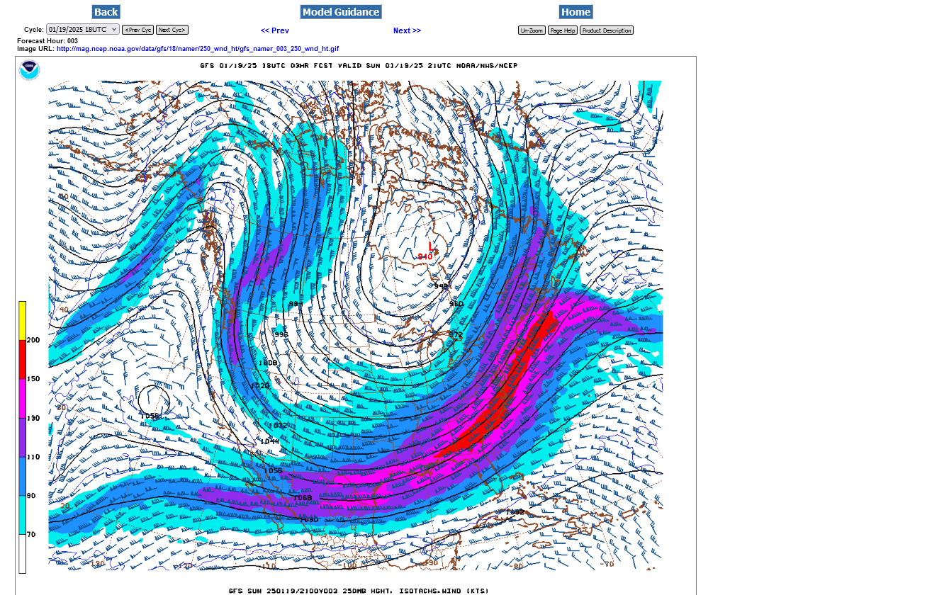
++++++++++++++
Great tutorials here:
| UNISYS MODEL INTERPRETATION AND DISCUSSION |
| PRES/PREC PROG | 1000 mb PROG | 850 mb PROG | 700 mb PROG |
| 500 mb PROG | 300 mb PROG | RH PROG | LI PROG |
| THE ULTIMATE WEATHER EDUCATION WEBSITE |

This will rev up more extremely strong Santa Ana winds again!!
Re: Re: Re: Re: Re: Re: California fires
By metmike - Jan. 19, 2025, 3:17 p.m.
This is NOT from climate change/global warming!!!!!!
A Winter Storm Warning is in effect from Monday night into Tuesday. The I-35 corridor and points east can expect a snow and sleet mix with up to 2 inches possible. Up to a tenth of an inch of ice is also possible across the warning area. Areas west of the I-35 corridor will experience advisory conditions with up to an inch of a wintry mix of snow, sleet, and ice. Consider delaying travel Monday night through Tuesday.
A Freeze Warning for a hard freeze is in effect for portions of the Brazos Valley/Piney Woods through Monday morning. A Cold Weather Advisory is in effect for all of Southeast Texas through noon Monday.

With dangerously cold temperatures and wind chills in the forecast Monday through Wednesday, NOW is the time to prepare! Have in plan a place for the elderly and those who don’t have reliable access to warm shelter. Plan to bring animals in or prepare a shelter for them to stay warm. Make sure there is a way to get fresh unfrozen water. Check and protect pipes. Replace old and damaged insulation if needed.


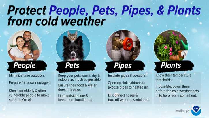
Protect People, Pets, Pipes, and Plants from cold weather. For people - minimize time outdoors; prepared for power outages; and check on elderly and other vulnerable people to make sure they are okay. For pets - keep your pets warm, dry, and indoors as much as possible; ensure their food and water does not freeze; limit outside time and keep them bundled up. For pipes - insulate pipes if possible; open up sink cabinets to expose pipes to heated air; disconnect hoses and turn off water to sprinklers. For plants - know their temperature thresholds and cover them before the cold weather sets in to help retain some heat. BE PREPARED! For more information, go to our Facebook and Twitter pages or listen to NOAA Weather Radio.

A winter storm watch is now in effect for nearly our entire forecast area as we monitor the upcoming winter storm Tuesday afternoon into Wednesday. Keep in mind, winter weather forecasts are tough, especially in the south. Forecast amounts are likely to change.

T


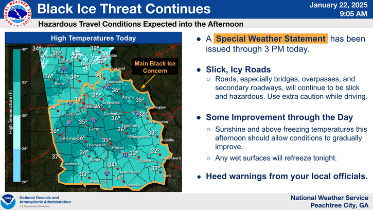
An Extreme Cold Warning has been issued for portions of north Georgia and the Atlanta metro. Dangerously cold wind chills will be possible Monday morning across north Georgia. Temperatures in the warning could feel as cold as 0F or less at times. All areas outside the Extreme Cold Warning could see frigid wind chills of 15F down to the single digits. For these areas, a Cold Weather Advisory has been issued.

Latest forecast from the 0z European model:
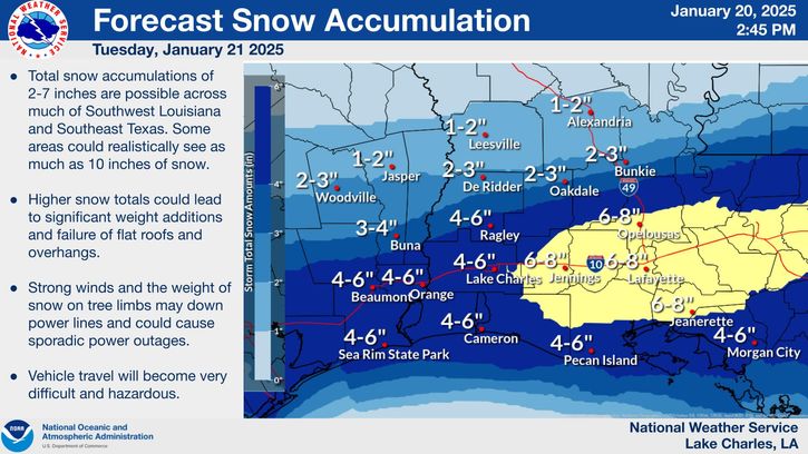
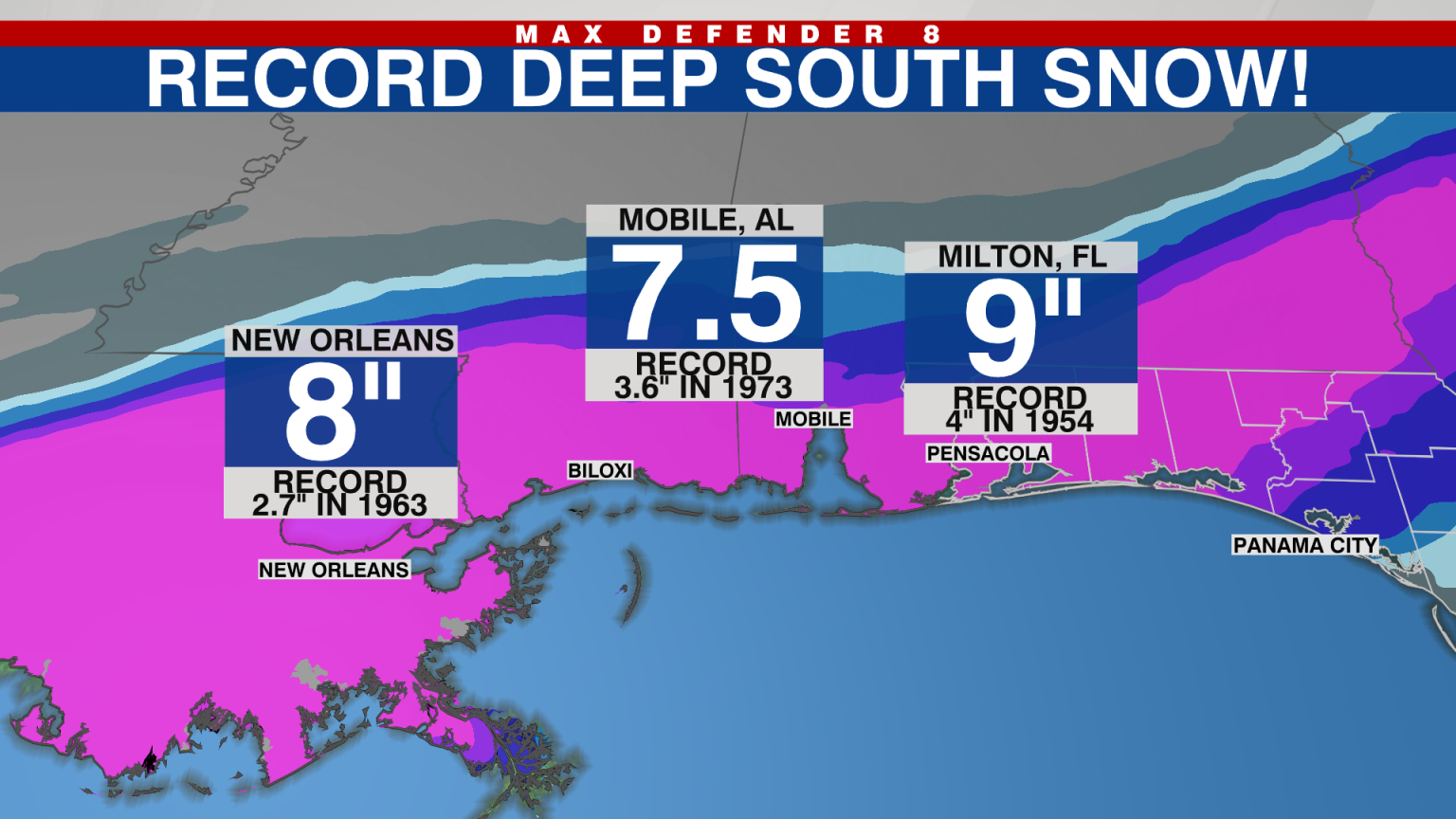
No big deal if this was for most places in the US. However, snows of this magnitude in far southern LA/southeastern TX have only happened a handful of times in the past 100+ years!
https://www.axios.com/local/new-orleans/2025/01/17/record-snowfall-new-orleans-louisiana-historic
https://www.axios.com/2025/01/09/snowfall-records-by-county
Records from 1872 to 2024
You won't see a radar image like this, with heavy snows along the Gulf Coast very often........like maybe once every couple of decades in this age of modest, mostly beneficial global warming from beneficially increasing CO2.
The top image is a freeze frame to capture it at just before 10am today, January 21, 2025. Sort of historical in nature!
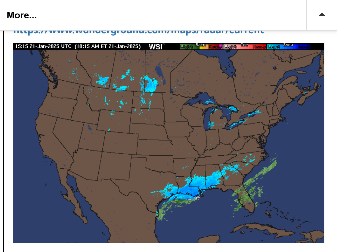
https://www.wunderground.com/maps/radar/current

How quickly does deep south warm up?
Pretty quickly tjc!
This snow will be all melted, except for the biggest piles by early next week.

https://www.nohrsc.noaa.gov/nsa/index.html?region=South&year=2025&month=1&day=22&units=e

Some really cool animations of the snow event:
++++++++++++++++++
National Map:
https://www.nohrsc.noaa.gov/nsa/index.html?region=National&year=2025&month=1&day=22&units=e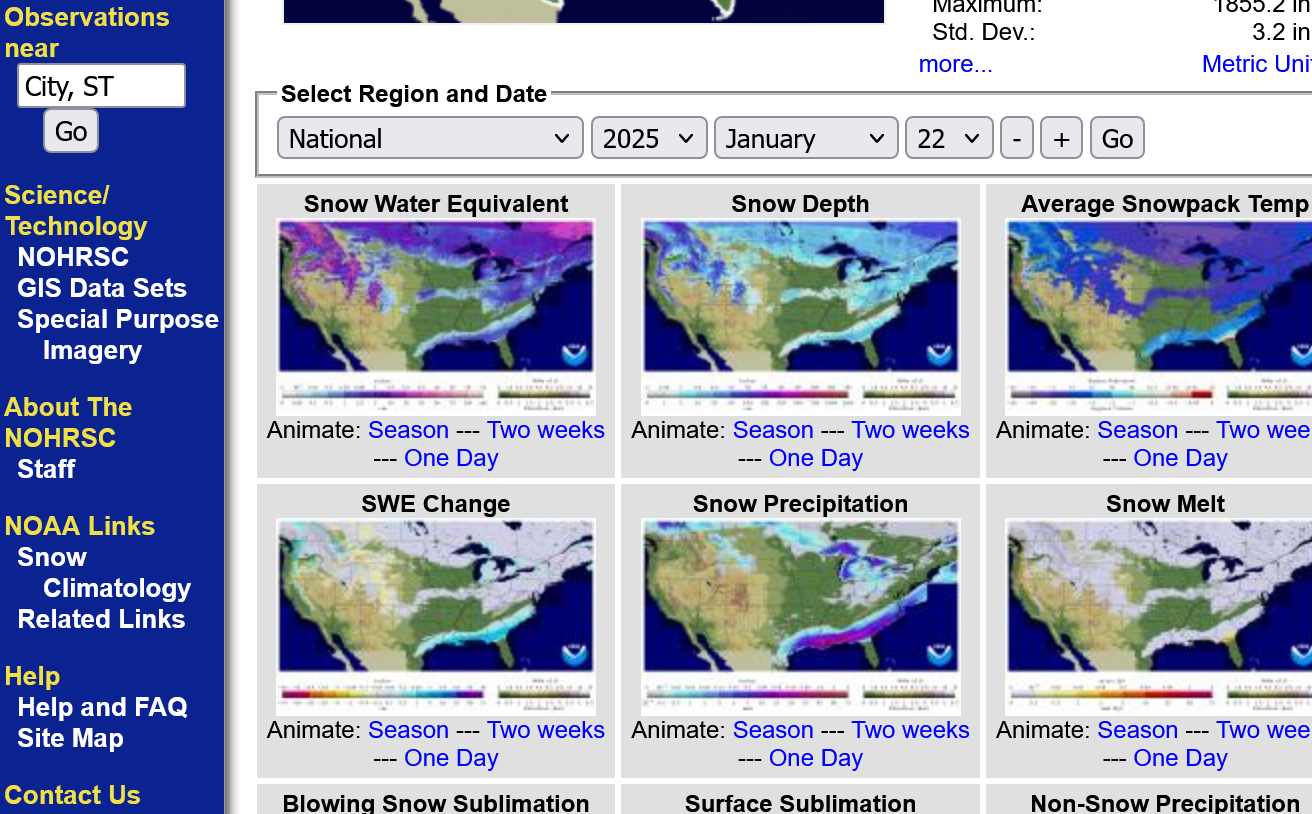
https://www.weather.gov/source/crh/snowmap.html?sid=ilx
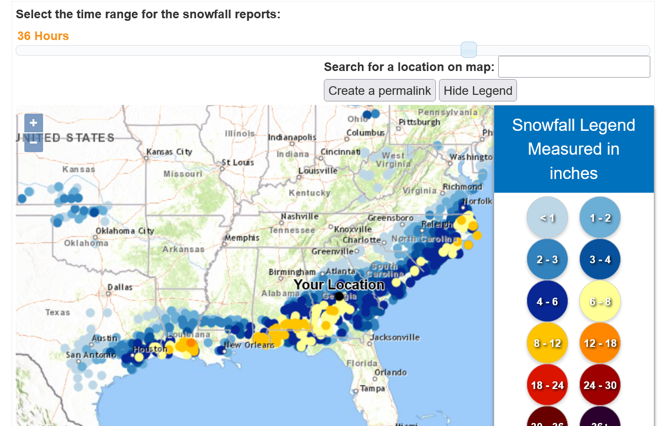
Several places over 8"
Looks like 1 report in LA of 12"+
No big deal if this was the Upper Midwest. A once in a lifetime snow event for the Gulf Coast.
https://www.wfla.com/weather/historic-deep-south-snow-the-science-behind-it/
Poor Jeff is blinded by bias and sees the climate crisis(global warming) foot print in almost every single extreme weather event that ever happens, even extreme cold and heavy snow and doesn't disappoint us this time.
That Polar Vortex, normally far north in Canada, is positioned in the northern U.S. — forced south by very warm air over the Arctic Ocean. It’s all connected.
What we can say is that the warmer air in the Arctic influences the further south displacement of the Polar Vortex. And we can also say that the warmer Gulf produced heavier snowfall rates than it otherwise would have.
+++++++++++++++++++++++++++
metmike:
1. The Polar Vortex has been much farther south, maybe a dozen times in my life. Well south of the Canadian border in fact. It was farther south than this several times, just in the 1970's DURING GLOBAL COOLING!!!!
2. As such, the prevailing principle that determines records like this is stated below with the "Golden Rule" because THE WEATHER played such a critical role.
++++++++++++++
It really boils down to this, once again(Cliff Mass can be counted on as an elite source for using objective, authentic science)
https://cliffmass.blogspot.com/2016/03/the-golden-rule-of-climate-extremes.html
The GoldenRule
Considering the substantial confusion in the media about this critical issue, let me provide the GOLDENRULE OF CLIMATE EXTREMES. Here it is:
The more extreme a climate or weather record is, the greater the contribution of natural variability.
Or to put it a different way, the larger or more unusual an extreme, the higher proportion of the extreme is due to natural variability.
3. How to reduce the incidence of this type of weather pattern?
Have more global warming!
4. This was part of the exact same NATURAL WEATHER pattern that caused the extremely high "Santa Ana" winds in Southern California:
California fires
17 responses |
Started by metmike - Jan. 10, 2025, 11:49 a.m.
https://www.marketforum.com/forum/topic/109456/
5. This pattern would likely NOT have happened during a natural El Nino but is MUCH more likely to happen during the current, NATURAL LA NINA!
https://www.marketforum.com/forum/topic/109485/
6. Since global warming/climate change is warming the highest latitudes by almost 3 times as much as the lower latitudes, especially in the Winter, air masses coming from the highest latitudes ARE NOT AS COLD AS THEY WERE decades ago!!! This same pattern in the 1970s might have featured the Polar Vortex 800 miles farther south and temperatures 10 degrees colder. But thanks to the warming of the Arctic and Siberia in the Winters, we were much more protected this time, from the most extreme cold that used to exist in this same pattern more often 50 years ago.
7. We should note that as extreme as this cold has been, the Florida Orange groves were never threatened with a freeze as they were a dozen times in the past with a similar weather pattern. Why is that? GLOBAL WARMING/CLIMATE CHANGE!!!!
8. I've been an objective meteorologist for well over 4 decades and followed the weather closely for over 5 decades and have all the weather records from since the NWS started recording weather in the late 1800's. Most people don't have that and trust guys like Jeff who does this for a living, has all of that and knows 100 times more than them. I don't need to trust guys like Jeff because, often when nobody is there to hold them accountable, people's bias runs rampant and their biased interpretation of everything just feeds on itself(like an echo chamber of 1-although Jeff likes to interact with people that think like him that feed off of each other).......instead of having something to reign it in.
9. Do I have a bias? Heck yes I do. Everybody does and its a constant fight to apply the scientific method to offset that natural human bias!! It makes it easier to recognize the ones that don't.
10. Many of my posts here feature opinions that are the complete opposite of mine because this is an ANTI echo chamber!
Re: Re: December and 2024 temps UAH
By metmike - Jan. 22, 2025, 9:41 a.m.
 Austin/San Antonio Radar
 Weather Map
 Satellite Imagery
 Del Rio Radar
 Local Radar
 Florida Radar (TLH)
 Georgia Radar (VAX)
 Weather Map (Interactive)