All the weather, constantly updated here:
https://www.marketforum.com/forum/topic/83844/
++++++++++++++++++++
This will start the new weather thread covering our new Winter Weather pattern in this part of the country next week that features a PARADE OF WINTER STORMS!
Look for many dozens of timely updates and posts to come:
There will be a pattern change next week that brings several POSSIBLE chances for snow, starting around Tuesday, here in Southern IN, then lasting for at least 10 days after that.
It's still much too early to have any idea of how these systems will shape up.
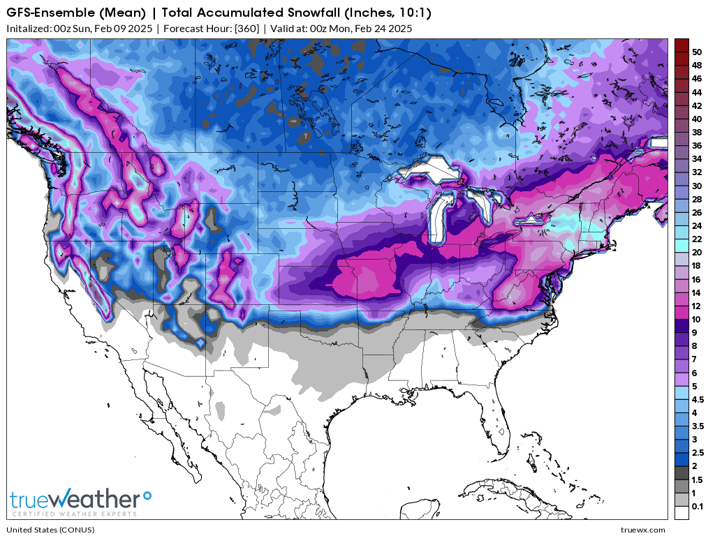
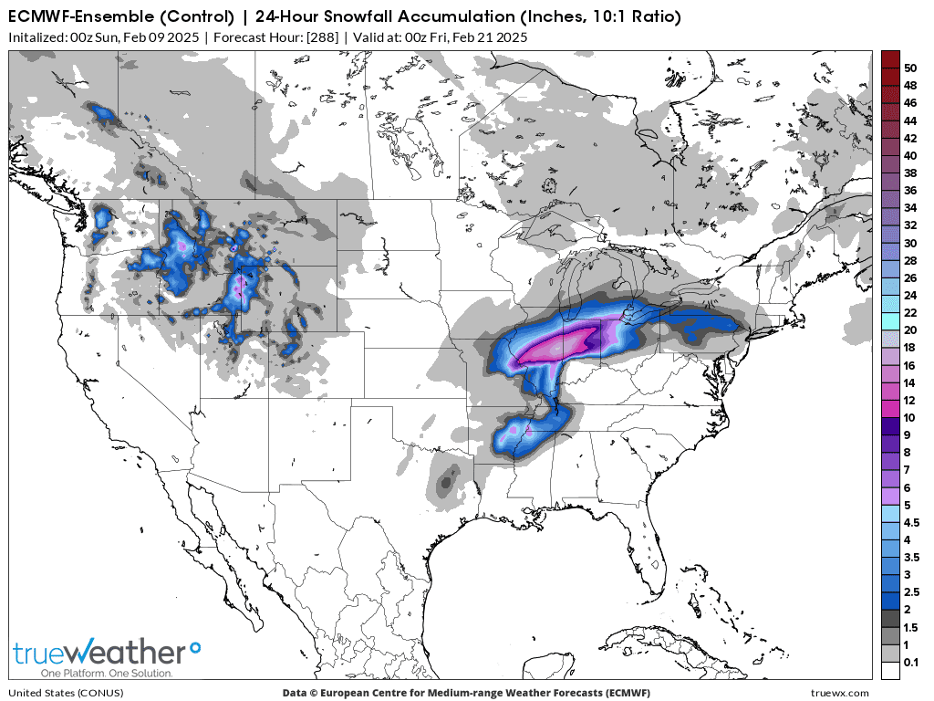
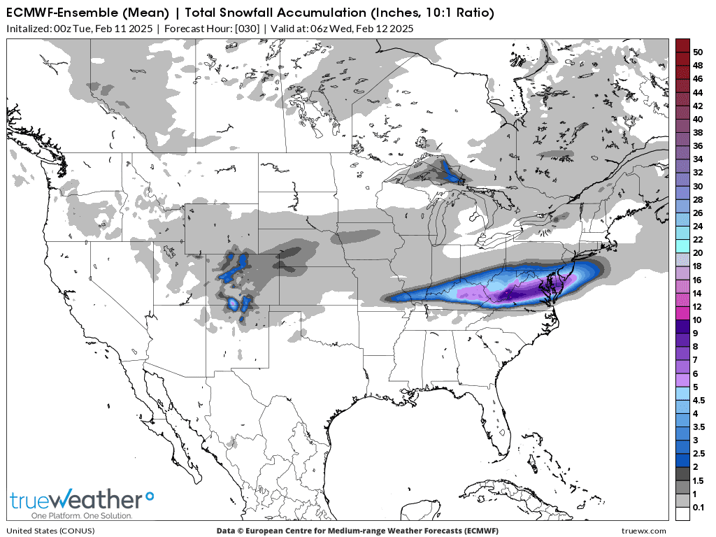
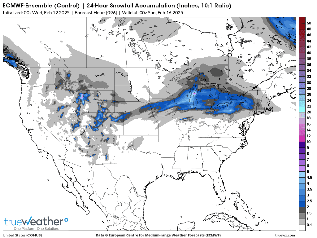
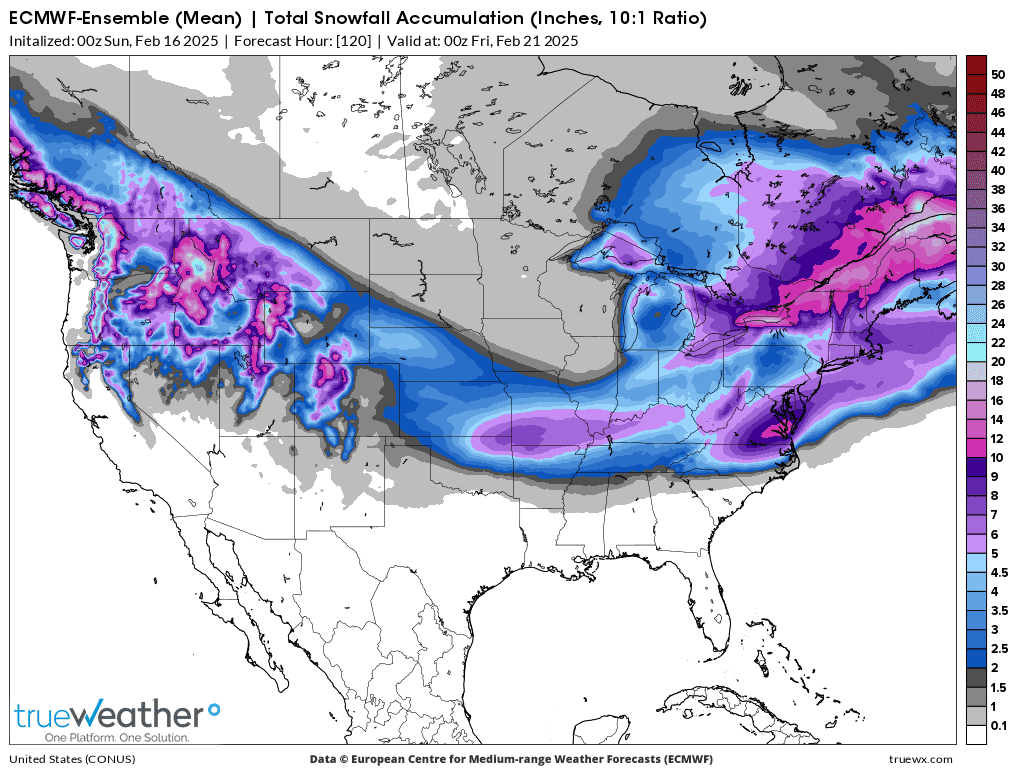
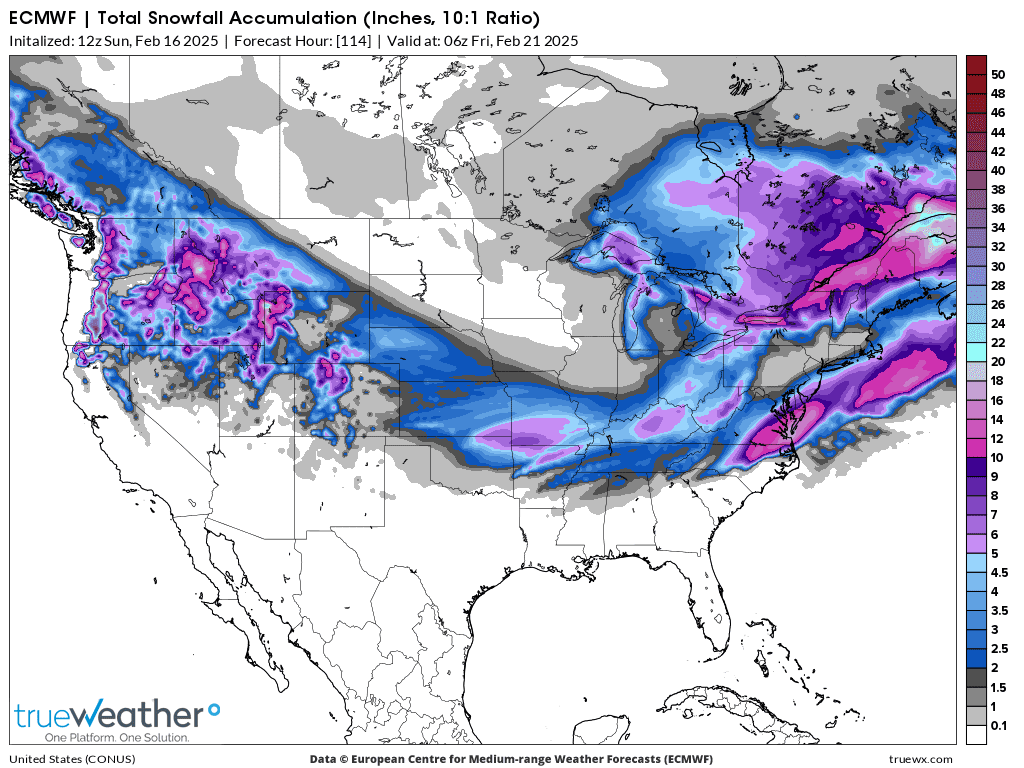
This was the last 12z European Ensemble model average forecast for total snow the next 15 days.
Don't read too much into the exact amounts, except to assume the farther north we go, the more snow is likely and that we are on the southern edge of a pretty steep snow gradient.
A slight shift north and we're mostly out of it.
A slight shift south and we could be targeted several times with snow events.
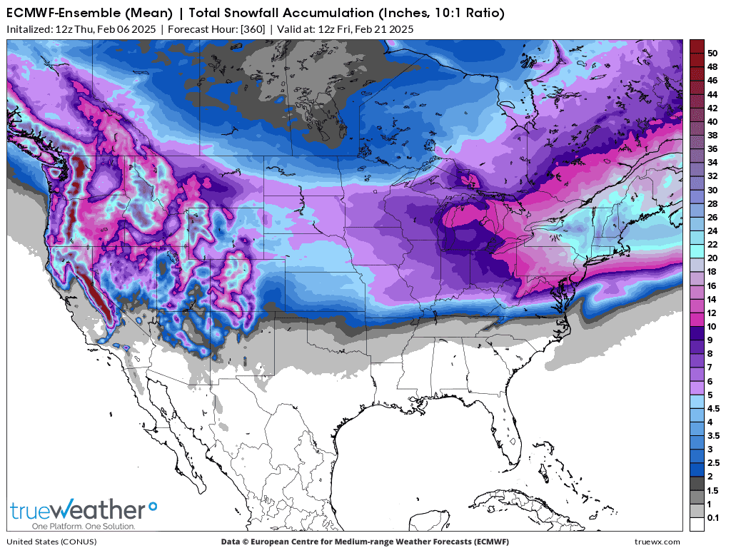
The Ensemble average is an average of 50 different, individual solutions from a model. Each one has 1 of the variables in the thousands of math equations tweeked. The equations representing the physical laws of the atmosphere have flaws in them, so that no one set is perfect. By slightly tweeking a different parameter in each ensemble member, we can get a RANGE of potential solutions. This allows us to imagine what the possible range of outcomes MIGHT look like. If the majority of the solutions agree on something, it gives us some confidence for that outcome.
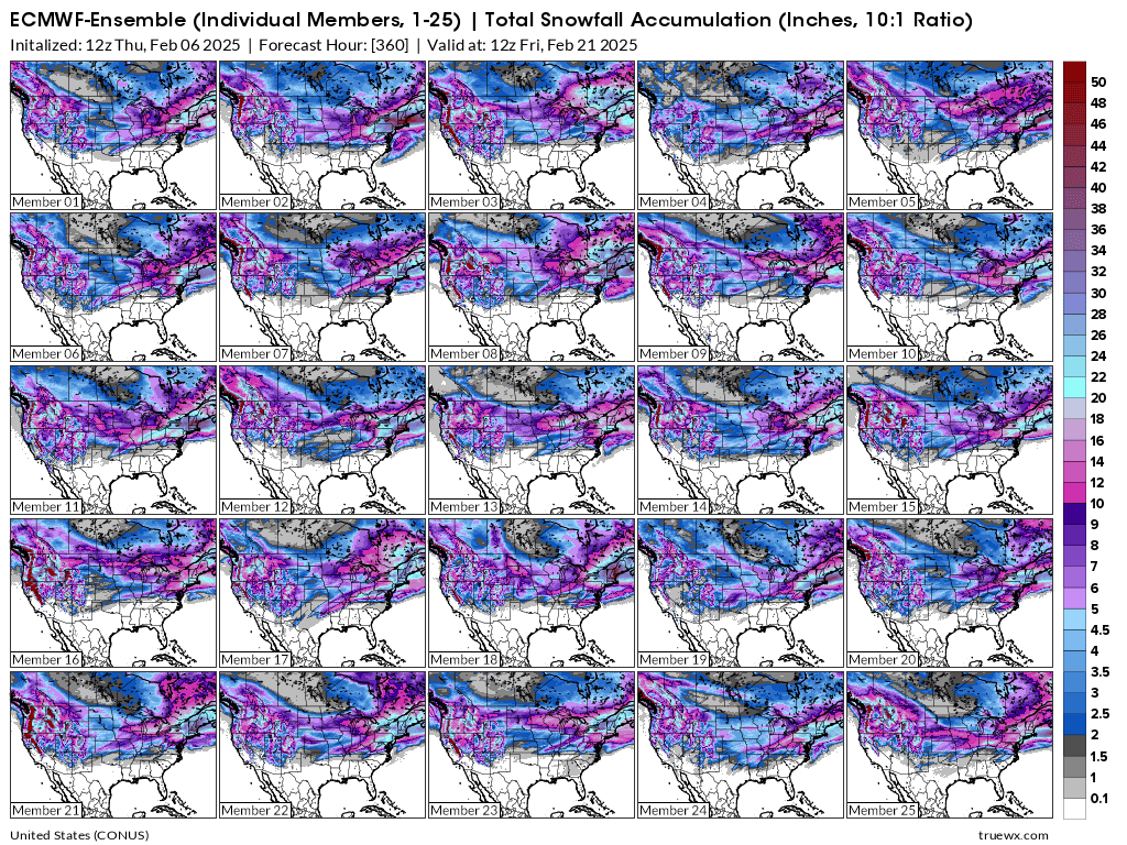
Below is a sample of the first 25 solutions/members(half of them) that went into the average above.
A few of them have almost no snow for Evansville, IN. #9 and #25 for instance.
1 of them has 20 inches of TOTAL snow. #11! This is an extreme outlier. We can say this is possible but not likely.
The thing to do is track the average and individual solutions as we get closer to the period and see if a trend (more or less) is apparent. This allows us to refine the forecast and add confidence(as long as there is solid agreement between the individual ensemble members).
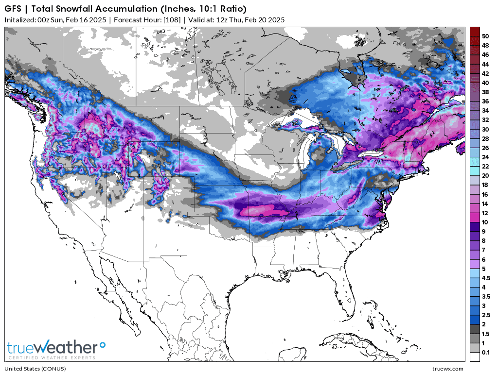
Regardless of whether the heavy snows are as far south as the Ohio River later this month, it's crystal clear that there will be widespread snows across the entire country from the Pacific Coast to the Atlantic Coast. The exact latitudes for individual events is what we don't know as well as amounts associated with each storm!
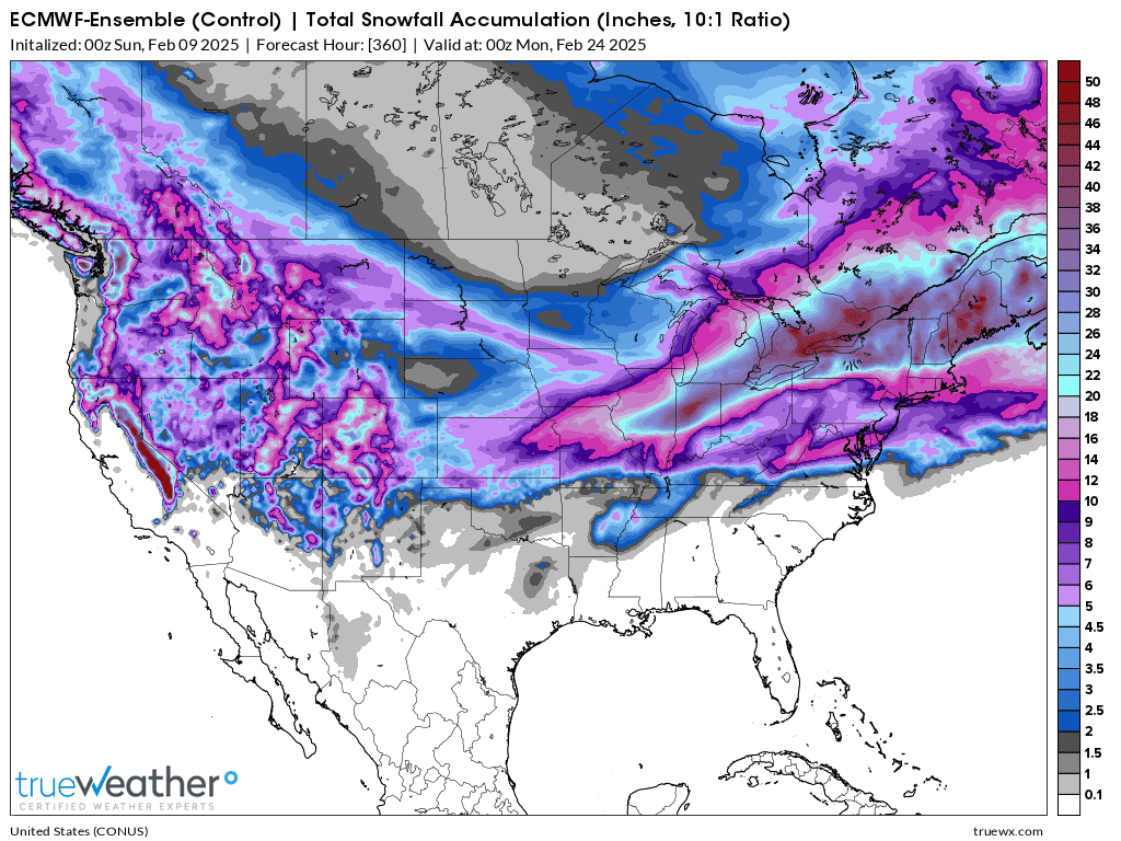
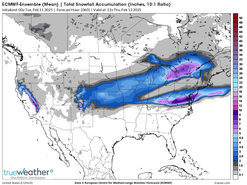
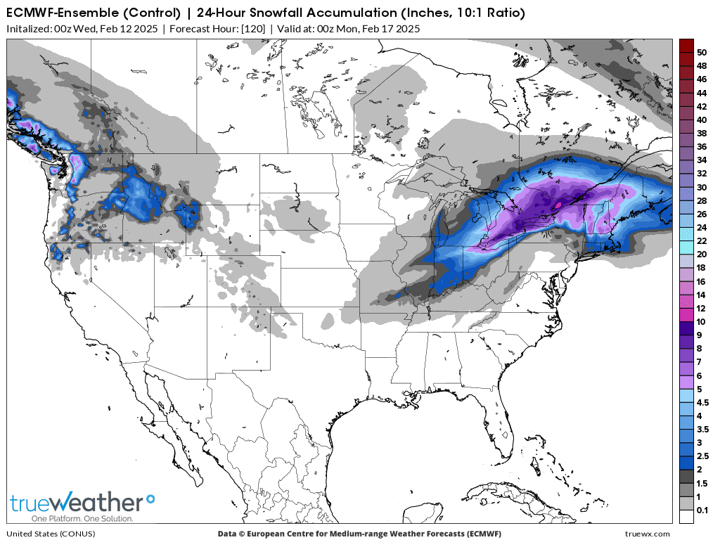
This last 0z European Ensemble has shifted the 2 week snow totals very slightly to the north(the type of change that's very expected this far out).
Snow amounts at the southern edge of the steep snowfall gradient, along the Ohio River have fallen off. It's misleading to assign an exact number to the total amount at any 1 point at this distant time frame because that implies the ability to forecast with a precision/skill that doesn't exist.
However, there is a very significant "big picture" to discern if we stand back and see "the pattern" with respect to a wider view on the larger scale.
1. Very cold vs average temperatures during this period.
2. Active weather, with numerous perturbations in the flow.
3. That combination spells out high confidence for numerous Winter weather events from coast to coast. The exact latitude of each one is very uncertain. The northern 1/2 of the US defines the Winter Weather zone.

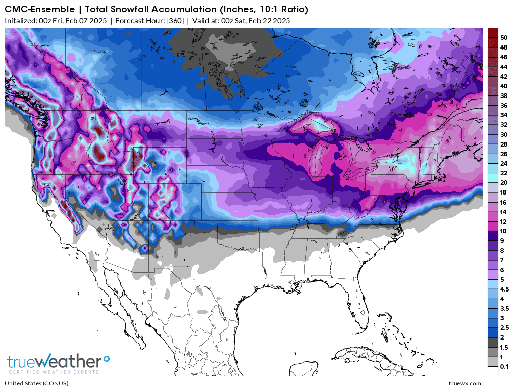
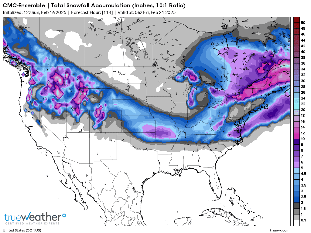
The Canadian Ensemble model below has the heavier snow just SOUTH of the Ohio River. It doesn't know a secret that the European model is missing. This is just part of the imperfection of weather models to accurately lock on to weather projections with precision at longer time frames. However, do note the same "BIG PICTURE" as the EE model above.
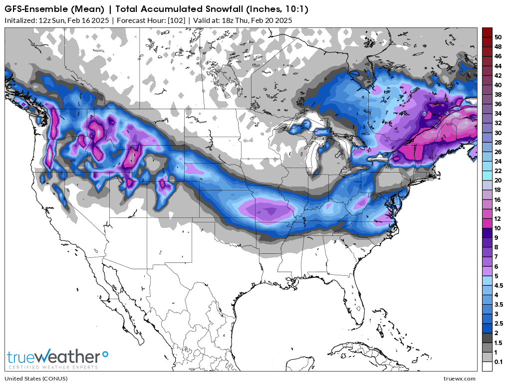
Now, heres the just out 6z GEFS, American model ensemble product below. Same big picture with an interesting variation(less snow) in southwest Indiana, likely from how it handles the biggest snow event. I can assure you that this twist will look different as time goes on.
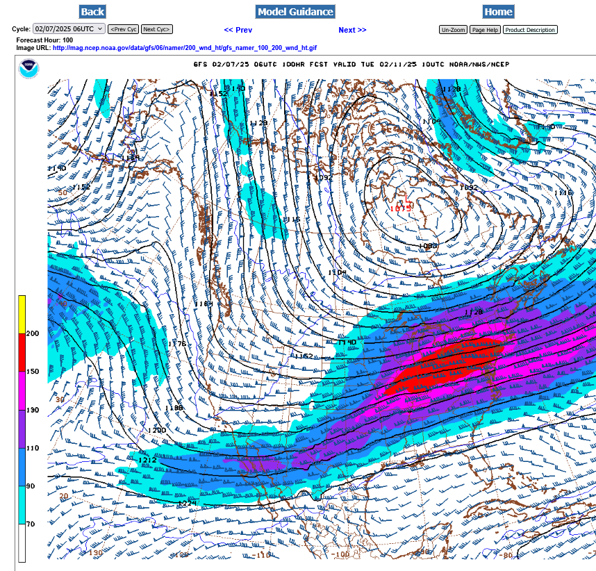
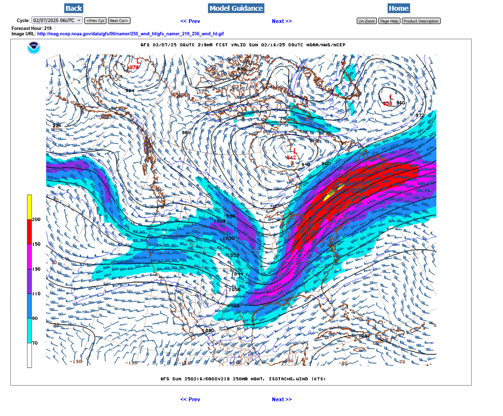
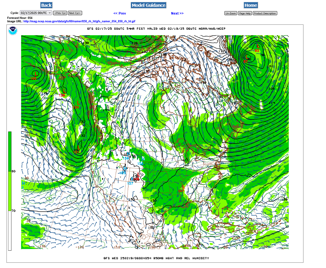
Here is the potential jet stream winds(at 250 mb) from the just out 6z GFS for various time frames, starting early next week with my analysis. The position of the jet stream will dictate the motions and spin in the atmosphere below it.
1. Next Tuesday 2-11-25. That's the Polar Vortex over the Hudson Bay, displaced unusually far south with an extension/trough into the US. The streamlines determining the winds and origin of air masses in Western Canada are coming from Siberia dumping frigid air thru Canada into the Western and Central US.
The red shade is a 150 knot jet streak= ~200 mph. There a lot of lift/upward motions associated with that.
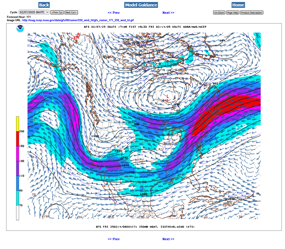
2. Next Friday 2-14 below. Happy Valentines day Winter Weather lovers! Polar vortex unusually far south with several perturbations around it and a powerful, Pacific jet stream(digging into a West Coast trough) with what is destined to be a major storm farther east when it phases with the northern stream from the Polar Vortex.
3. Jet stream 2-15-25. Some sort of phasing and strengthening in the 2 jet streams.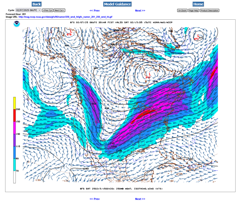
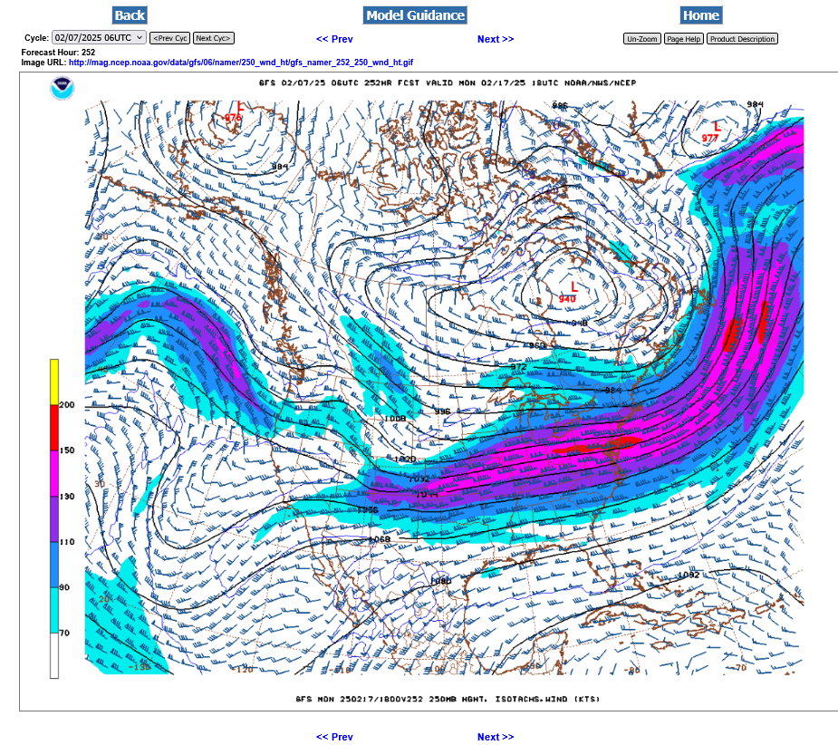
4. Jet stream 2-16-25. Look at the yellow, 200 knot jet streak in the northeast. This is around 230 mph!!! There is likely to be a MAJOR nor'easter or 2 from this pattern! To the west, MORE jet stream energy and more Winter weather precip coming.
5. 2-17-25. Polar vortex shifted/pulled slightly east with the departure of the Nor'easter into the Atlantic a continuation of the cold feed underneath it. Plenty of perturbations and jet stream energy from the Pacific and from the Polar Vortex.
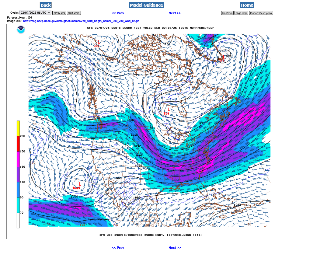
6. 2-19-25. Polar Vortex gets pulled back/reforms southwest as a new MAJOR storm forms in the Eastern half of the country from the phasing of the northern and Pacific stream energy.
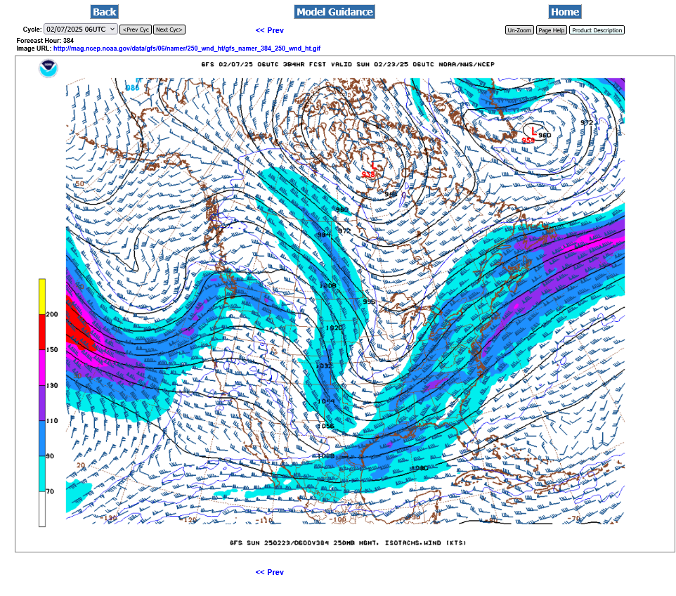
7. 1-23-25. Last map at 384 hours. Models can't predict exactness this far out but the same pattern remains intact but with some potential signs of a change. A cold northern stream and Pacific stream are interacting with a huge part of the country and causing all the snow in the forecasts on the previous pages.
Speculation: The magnitude of the powerful Pacific Jet Stream aimed at the West Coast, just coming into view on this image has the potential to define a NEW pattern, with the Polar Vortex appearing to retreat northward on this map. Will this spell a warm up at the end of the month? Could be.
Much more coming shortly!
This will change but currently, even with this Wintry pattern next week there are no specific MAJOR Winter storm events that are taking aim directly at Indiana.
A minor one early next week. This is the chance for 1 inch of snow late Monday Night, early Tuesday.
https://www.wpc.ncep.noaa.gov/pwpf/wwd_accum_probs.php?fpd=24&ptype=snow&amt=null&day=3
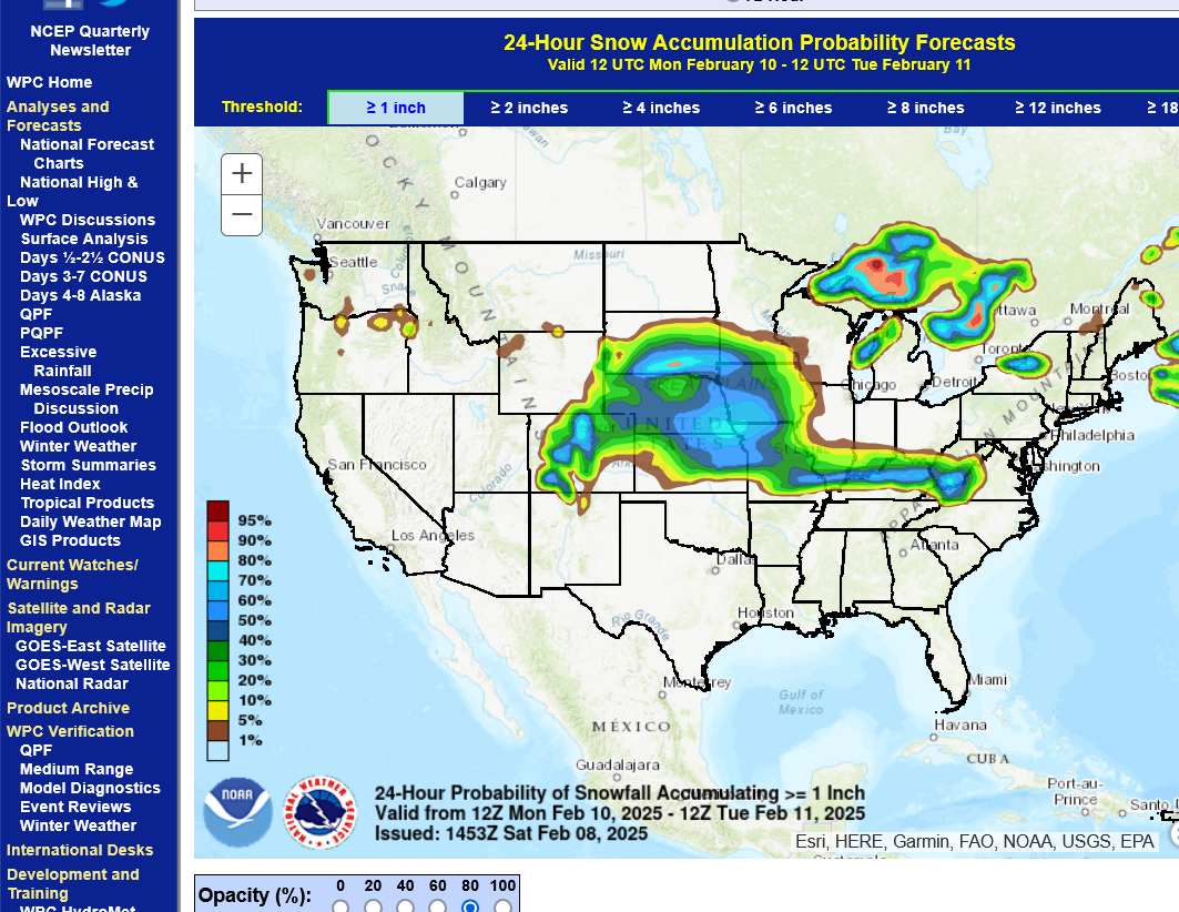
During that time frame very early Tuesday, maybe a bit over an inch of wet snow with a temp around freezing means most of it would melt on the roads.
Another chance for around an inch on Wednesday PM with temperatures around freezing and most of it melting on the roads:
This WILL change!!!
National Weather Service for the Evansville region:
Current Hazards at the link below.
Go to the link below, hit hazards box in the top right hand corner(it will also define all the color codes), if its not already in the hazards mode when you load the link.
Then you can hit any spot on the map, including where you live and it will go to that NWS with all the comprehensive local weather information for that/your county.

The way the models THINK this will shape up the next week is with a big snow event(s) to our northwest, then north and a big one to our east. With the Northeast getting NAILED by 2 nor'easters. This is very consistent with the jet stream pattern showed a few days ago/above (maxing out in the Northeast), higher up in this thread.
We should still note the widespread snow from the Pacific Ocean, across the entire country to the Atlantic ocean.
The Ohio River is near the southern edge of the significant snow, which is likely to be shifting around as we get closer to the events and the models have better/more reliable data to process.
This just out 0z GEFS(US model) continues with the same outlook the next 2 weeks.
If you live in Evansville IN, heavy snow to your west, north and east with just light amounts the next 2 weeks.
Places in the Northeast may see close to 2 feet of snow! This could still change.
The very odd configuration of the total snowfall forecast all around us is the result of the expected paths of Winter storms the next 2 weeks. Keep in mind the forecasts below are only for the 24 hour period when Indiana is targeted with the heaviest snows.
Below: 24 hour snows from the first, early Tuesday system: heaviest to our EAST(Storm organizes AFTER passing by Evansville, IN)
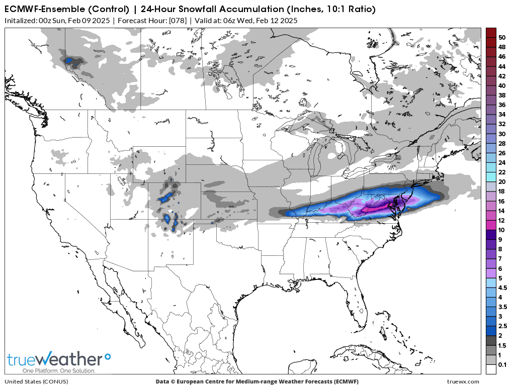
++++++
24 hour snows from the late Wednesday system: Heaviest WEST AND NORTH(Evansville, IN on the warm side) but northern IN could get dumped on.
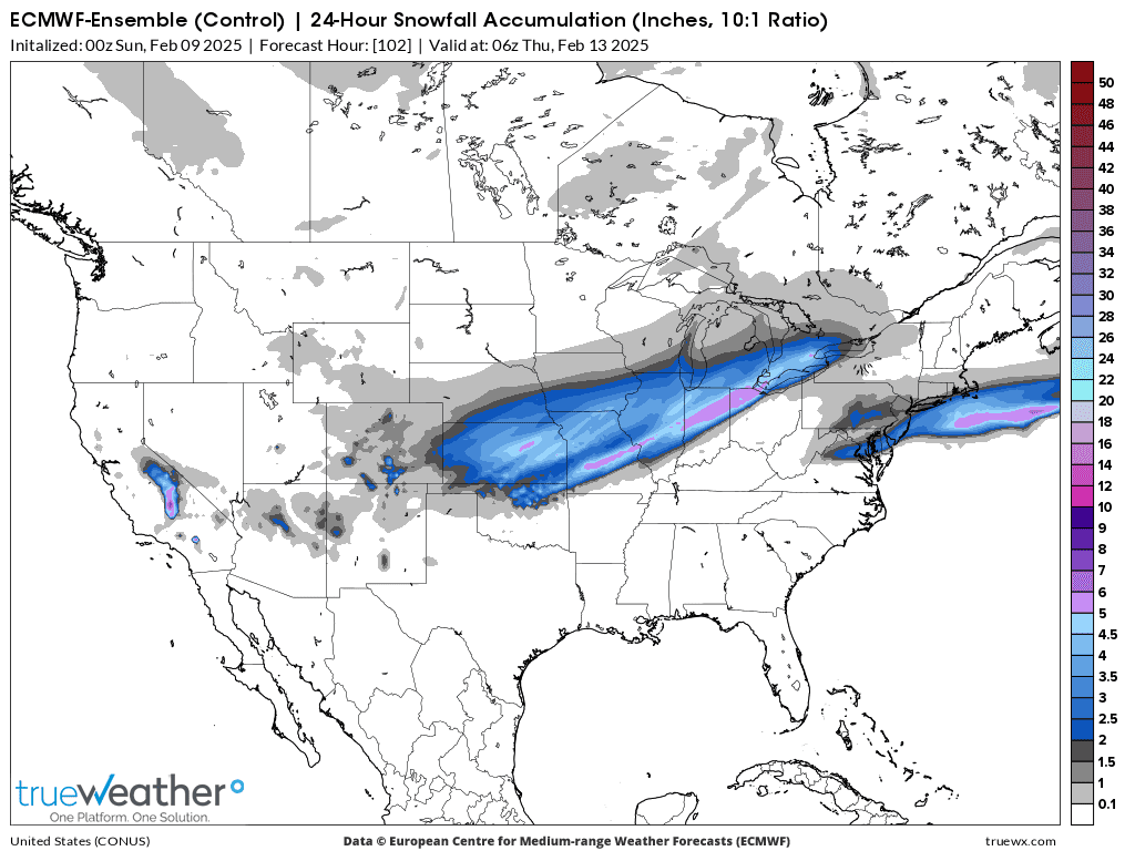
++++++++++++++
24 hour snows for early next weekend: Evansville on the warm side again but parts of Indiana could get dumped on.:
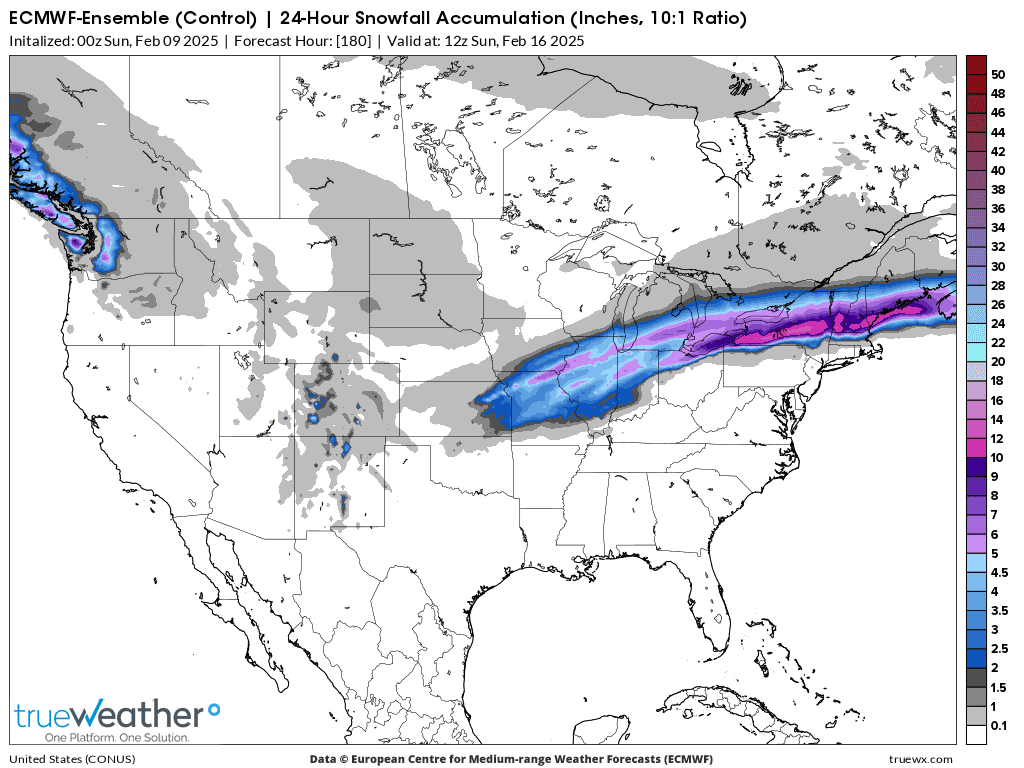
++++++++++++++
Here's another potential storm in 11 days(a week from Thursday).
++++++++++++
Just beyond these 24 hour periods is when the storms organize in the NORTHEAST and create Nor'easters with big snow amounts.
The exact track of these storm is uncertain, especially those that are farther out.
++++++++++++++++++++
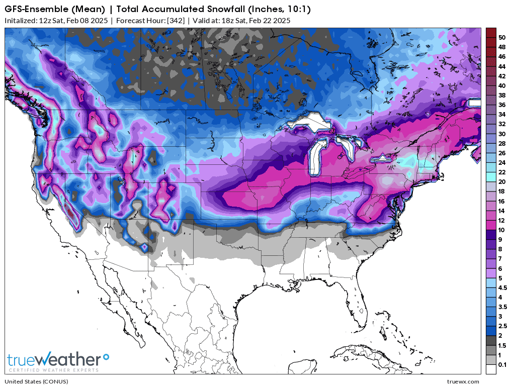
If you add them all up, you get something like this below. I picked the SNOW BULLISH European operation solution for 2 week snow totals because it hits us with the backside of system #4 above.
Reality check: Assuming that every system will go around us and the models can actually forecast such a thing for the next 2 weeks is unrealistic confidence in their capability. A slight change farther south or east in the path of the jet stream and storm track of each storm is possible which means the heaviest snows would shift in that direction.
Same thing with a farther north/west shift.
1. One thing with near 100% certainty: There is going to be a ton of snow from the Pacific Coast to the Atlantic Coast. Amounts in the Northeast could pile up in FEET.
2. The NORTHWESTERN half of Indiana is a favored location for where these storms could start coming together, where the Arctic and Pacific jet streams begin to phase but with the uncertainty of LOCATION for this higher confidence phasing of "somewhere" in that vicinity. Increasing in chance, as we go farther northeast.
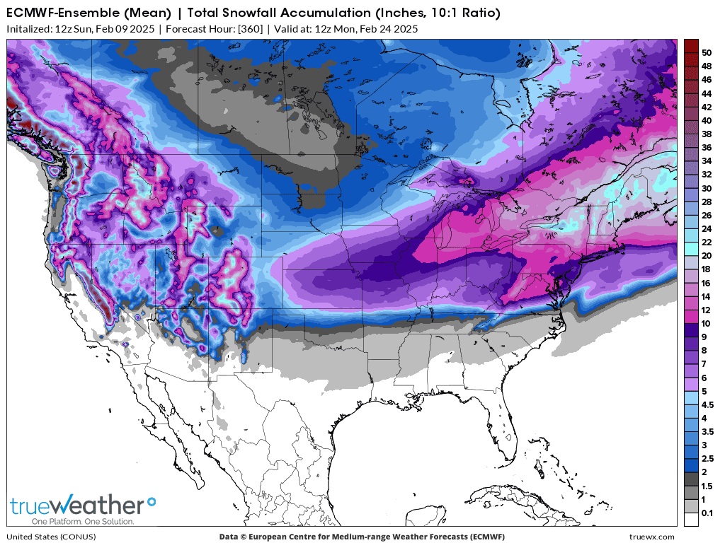
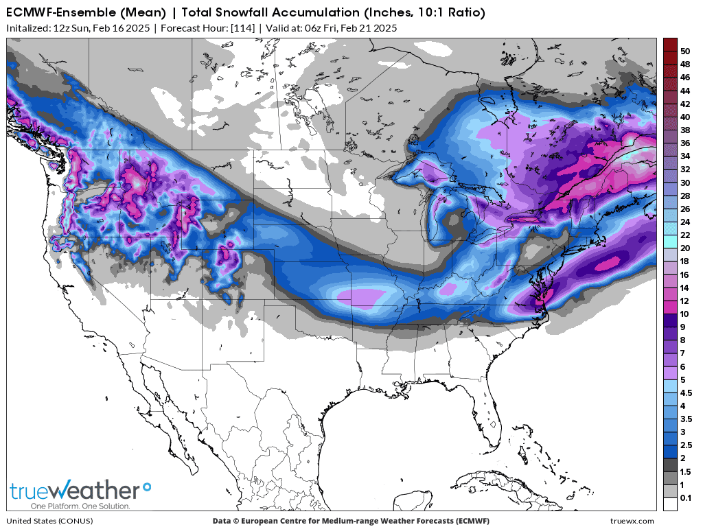
This the last 2 week snow forecast from the just out 12z European Ensemble model(does better than the others).
The higher amounts in S. Indiana are from the storm that's 10/11 days out. Our weather models are awesome and are much improved during the past 4+ decades of my forecasting weather career but they CAN'T pinpoint heavy snow amounts with that much accuracy that far out!
Tracking the Winter Storm:
Current Hazards at the link below.
Go to the link below, hit hazards box in the top right hand corner(it will also define all the color codes), if its not already in the hazards mode when you load the link.
Then you can hit any spot on the map, including where you live and it will go to that NWS with all the comprehensive local weather information for that/your county.
https://www.wunderground.com/maps/radar/current

Winter Weather Forecasts
https://www.wpc.ncep.noaa.gov/wwd/winter_wx.shtml


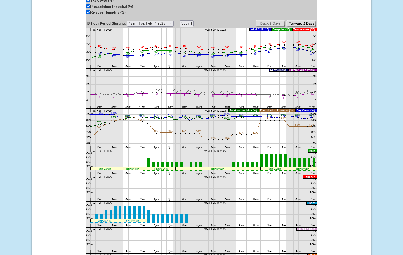
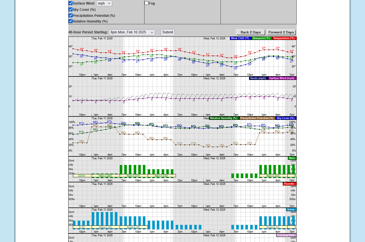
metmike: Up to 2 inches possible in Evansville but the roads are warm and the air temp will be at or just above freezing so most of it should melt quickly on the roads.
Grassy areas will get some minor accumulations.
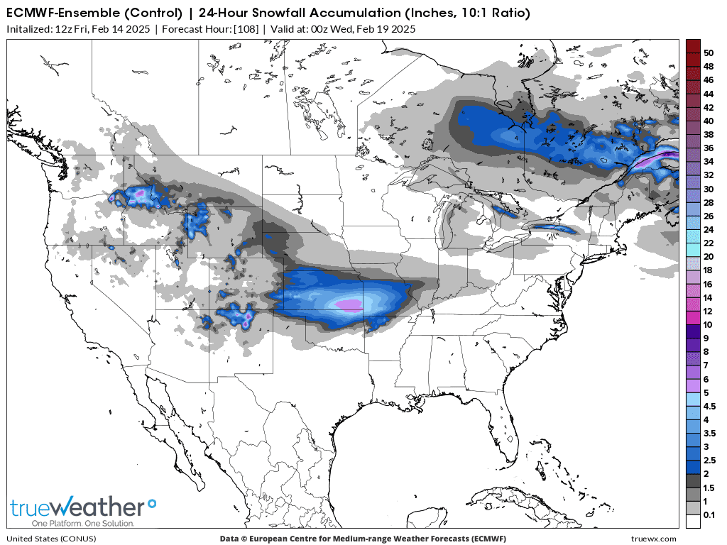
4 Separate Winter Storms the next 9 days.
24 hour snow totals below from the just out 0z European Ensemble model
Storm 1: Now thru Tuesday(minor amounts in Evansville)
+++++++++++
Totals for snow from Storm 1(Tuesday) & Storm 2(Wednesday-much farther northwest): Rain in Evansville
+++++++++++++++
24 hour snow total Storm 3: Rain in Evansville
1. Saturday
2. Sunday
++++++++++++
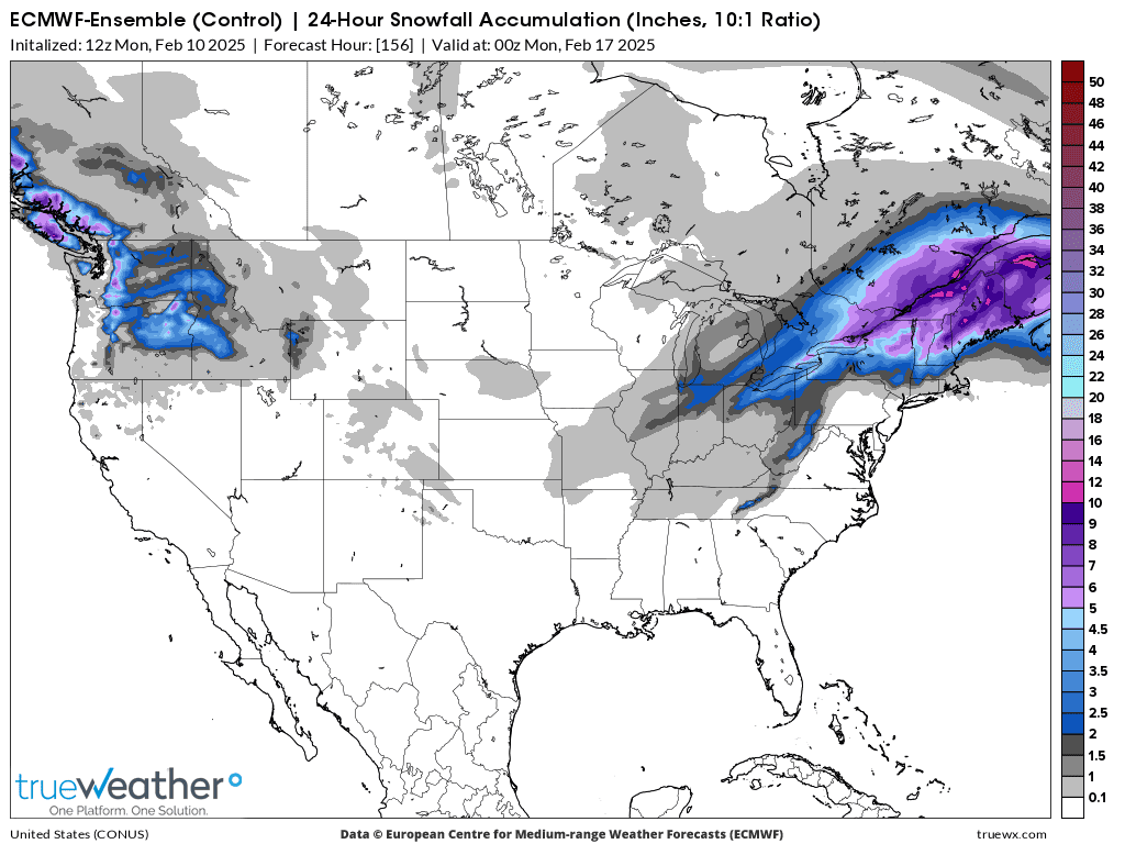
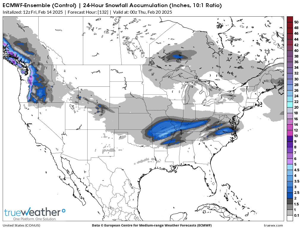
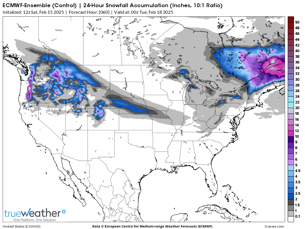
Winter Storm 4: 24 hours Tuesday, Feb 18
++++++++++++
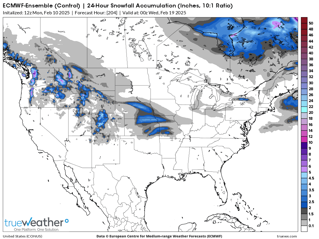
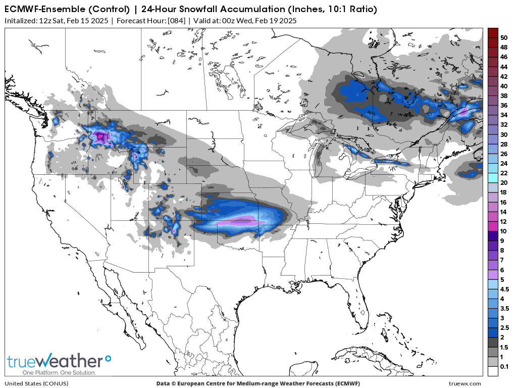
Wednesday-Feb 19th snow total for 24 hours below-This is the one to watch!!

++++++++++++++++++++++++++++
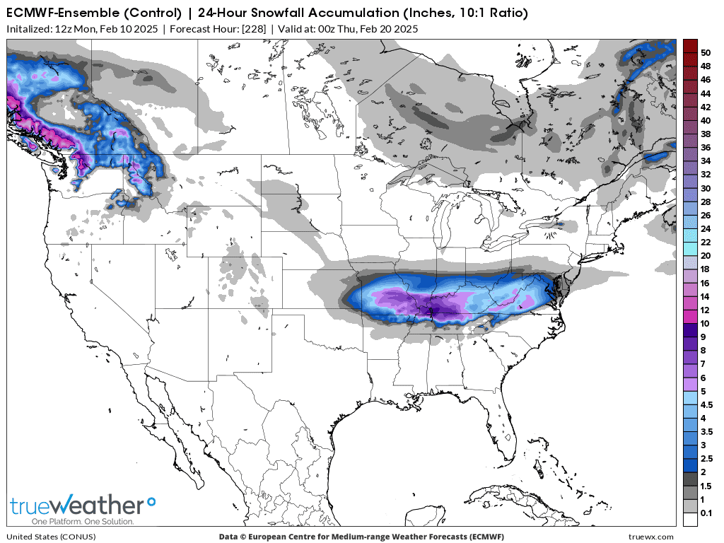
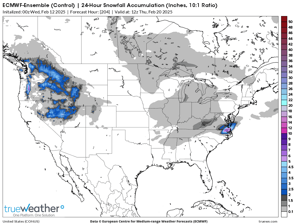
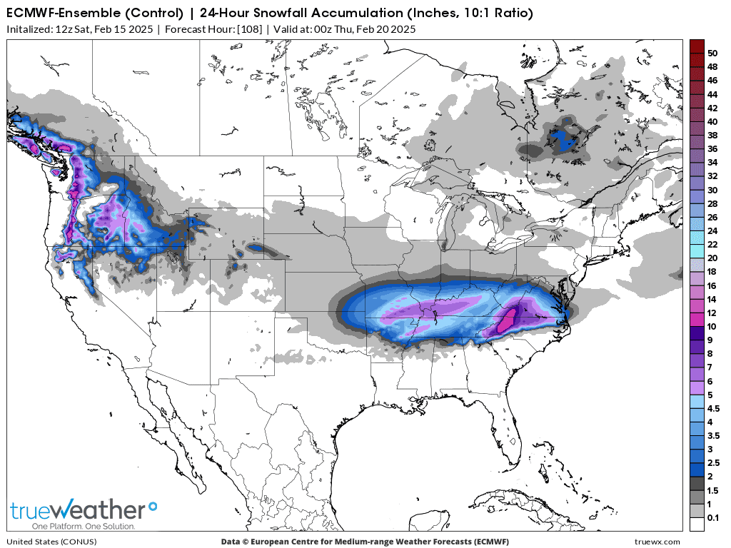
Thursday-Feb 20 snow total 24 hours below:

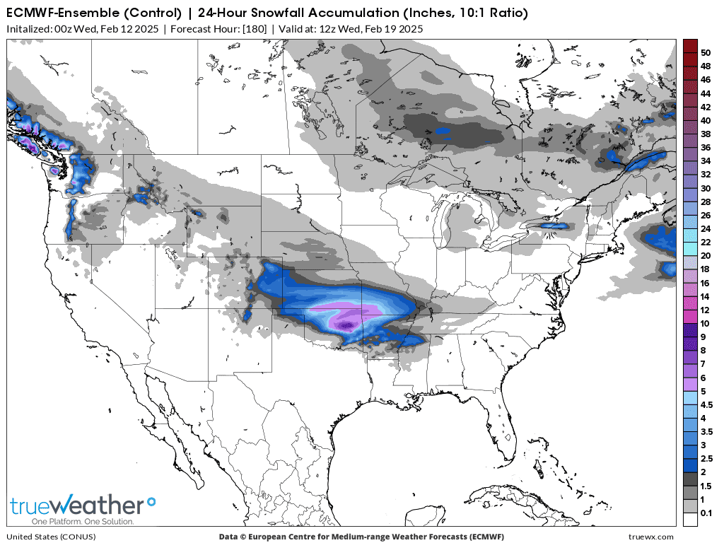
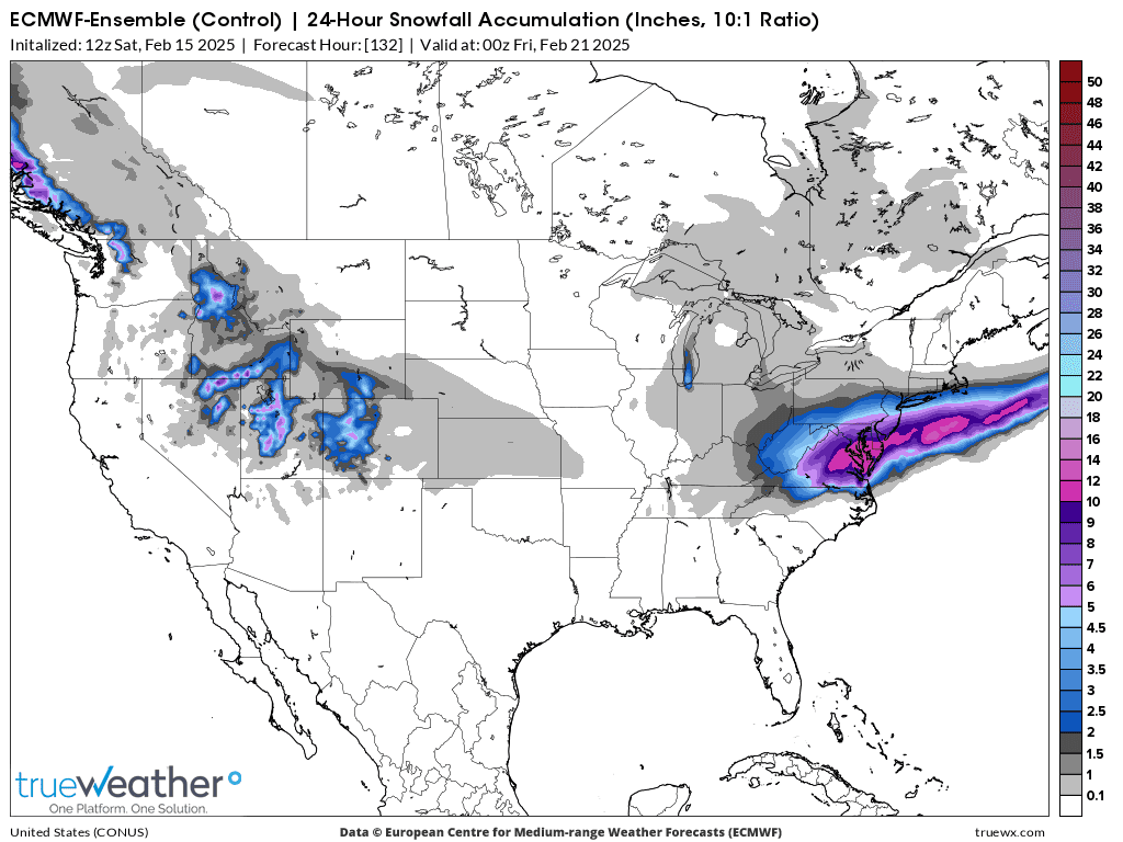
Here's the last 0z European Ensemble forecast for storm #4 in the middle of NEXT week(Feb 18-19-20).
This WILL change!!!


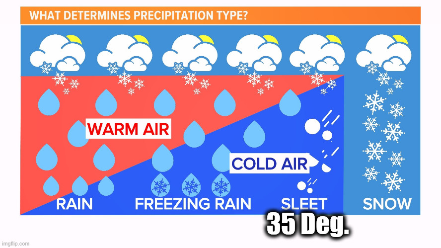
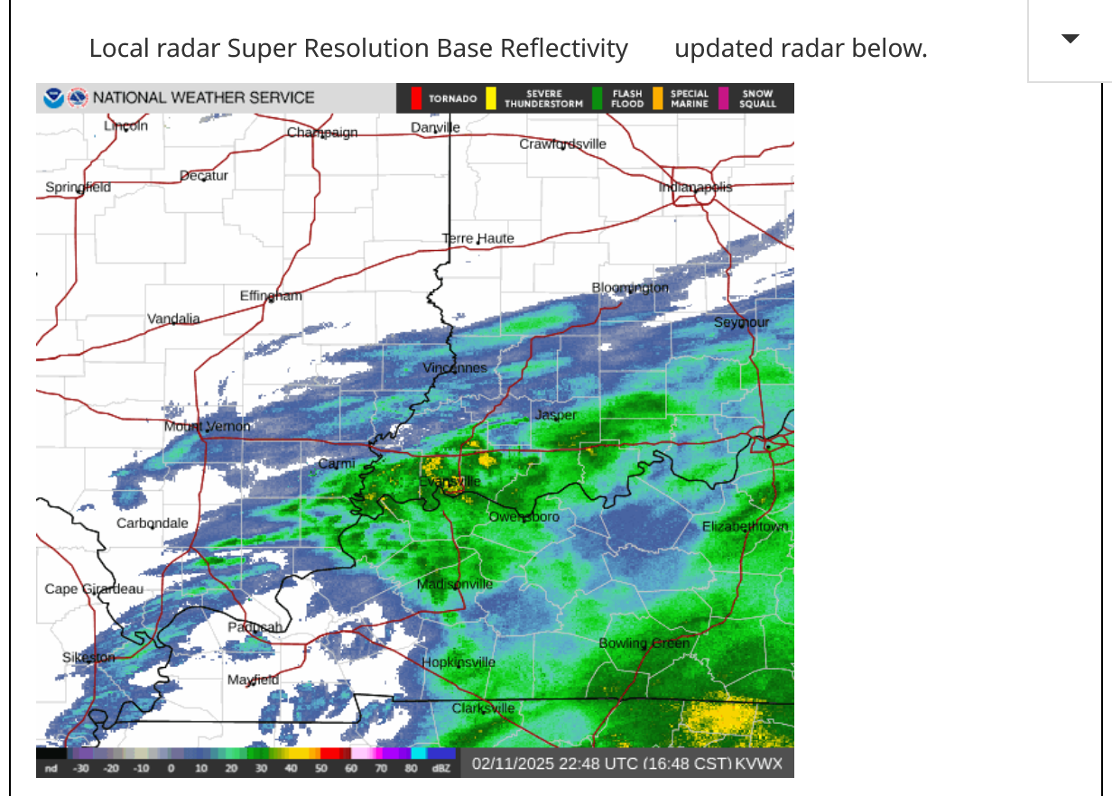
A little sleet coming thru Evansville just after 1:30 pm. Sleet pellets are strongly reflected by the radar beam. This is light sleet below. Moderate to heavy sleet can have a similar signature to a severe thunderstorm because of its ability to reflect the radar beam back!
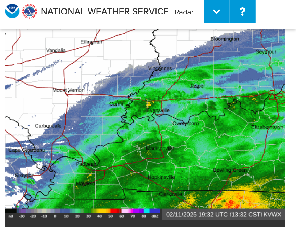
Local radar Super Resolution Base Reflectivity updated radar below.

Based on the melted equivalent of snow/sleet at the NWS site just south of our house, we'll probably end up with close to 1.5 inches total of snow, then sleet that all melted quickly on the warm roads, with an air temperature that never dropped below 33.
It's currently 35. We are having sleet because there is a cold pocket above the surface which is freezing the falling rain before it reaches the ground! Usually, sleet falls when the surface temp is below freezing and a warm pocket aloft causes the precip to fall as rain but then a colder pocket above the ground causes it to freeze before hitting the ground.
For the current condition, take this graphic below but add another shallow warm pocket(35 deg. F) right at the surface for us.
We've continued to have pockets of sleet, moderate at times this afternoon that has caused very slick untreated sidewalks and even some roads are slick. Going into Scott school for chess just before 3pm, the sidewalks were all wet, no slick spots. Coming out for dismissal after chess at 4:15pm, ALL the sidewalks were covered in sleet. Roads also slick in many places.
Wayne Hart is usually the best on WEHT but he continues to miss the magnitude of this sleet event when interpreting his radar. I wouldn’t have appreciated it either ……..but it was on top of me!!
Our weather technology gives us a billion times more information than what was available a century ago but sometimes a real person observing on the ground or with a rain gauge will beat it!!!
The freeze frame below was at 4:48 pm. The yellow pockets are the high reflectivity of sleet more than an intensity indicator.
This next storm is dumping snow!
https://www.marketforum.com/forum/topic/83844/
https://www.wunderground.com/maps/radar/current
Winter Weather Forecasts
https://www.wpc.ncep.noaa.gov/wwd/winter_wx.shtml
+++++++++++++++
You can scroll down and get almost the entire comprehensive weather picture updated constantly here.
Current Hazards at the link below.
Go to the link below, hit hazards box in the top right hand corner(it will also define all the color codes), if its not already in the hazards mode when you load the link.
Then you can hit any spot on the map, including where you live and it will go to that NWS with all the comprehensive local weather information for that/your county.
Next week's snow event is much less impressive on today's weather maps. It falls apart moving east:
1. 24 hour snow Wednesday Morning
2. 24 hour snow Thursday Morning.
The Weekend storm is still coming but mainly in the Northeast for the HEAVIEST snows:
1. 24 hours Saturday midnight.
2. 24 hours Sunday midnight.
Hey Mike,
FYI 12Z Euro is running at least an hour late getting started and there’s no resumption time being given yet.
Around 2 inches snow this morning, but currently in the dry slot. Hopefully we won't get much more. 1;30 p.m.
Thanks Larry!
the 12z European model never came out.
++++++++
Finally came out. +16HDDs vs the previous 0z run so NG has spiked higher in early evening trading! Small gap higher on the open. Unusual for a non sunday night open.
I was thinking that we might be getting close to the top!
some of the solutions are trying to go back to really cold in 2 weeks. Much uncertainty.
++++++++++++++
Thanks, bowyer!
Maybe 5 inches of rain in Western Ky on Saturday! Heaviest rains will be SOUTH of Indiana!
https://www.wpc.ncep.noaa.gov/qpf/excessive_rainfall_outlook_ero.php
%20Interactive%20Display.png)
+++++++++++++++++++++
++++++++++++++++++++++++++++++++
Initial estimate for next Tuesday Night/Early Wednesday snow in Evansville: 3 inches?
This will LIKELY change as we get closer. The ground will be frozen, with temperatures well below freezing so it WILL STICK AND ACCUMULATE! School is unlikely next Wednesday!
24 hour snow totals next week:
1. Tuesday
2. Wednesday
3. Thursday
Constantly updated comprehensive weather:
https://www.marketforum.com/forum/topic/83844/
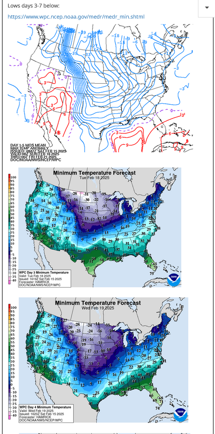
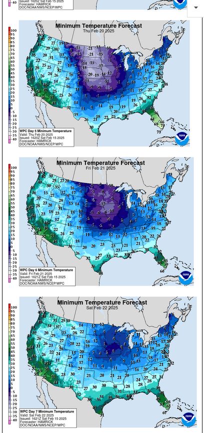
LOW Temperatures next week.
https://www.marketforum.com/forum/topic/83844/
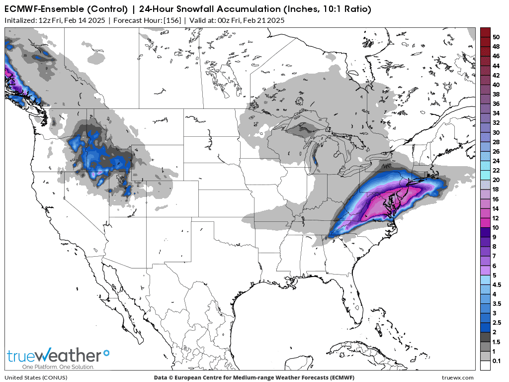
Snow amounts are going up in my forecast!
This is the last 12z GFS for Sunday. Will this much snow (4+ inches)happen??? Probably not but its a possible surprise.

The rest of the week below from the European model. This WILL change!
1. Sunday-2+ inches possible very early
2. Monday
3. Tuesday-snow starts very late evening in Evansville
4. Wednesday-5+ inches possible-heavier south
5. Thursday
Live updates on the flooding in KY and other weather from Ryan Hall Y'all!
The snowfall amount gradient will be extremely steep so a slight shift In the forecast will cause a big adjustment.
Here on Sunday morning, I’ll go with around 6 inches for the lateTuesday/early Wednesday Winter storm.
This one will occur with a temperature well down iinto the 20s, falling into the teens, so the snow will be drier than usual (not good packing).
The same amount of moisture that makes an inch of snow with a temperature near freezing will make near 2 inches of snow in this event.
A shift farther south and we might get less than 2 inches. If the storm organizes a bit more, then 10 inches is possible.
Wednesday and Thursday, temperatures will struggle to get out of the teens during the day!
++++++++++++++++++++++++++++++++
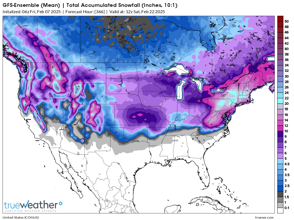
This is the total snow for the next 5 days. The snow from the Plains to the Ohio River to the MidAtlantic are mostly from the NEXT event.
1. Look what the just out 12z GEFS model does with the total snow forecast!
2. Below it, is the forecast for the "parent" solution/model, the individual, operational GFS.
This last run of the European model guidance is less bullish on snow amounts.
1. 12z Ensemble mean
2. 12z Operational model
3. 12z Canadian Ensemble also has less snow
Let's adjust the most likely amount down to 4-5 inches, keeping in mind that only .2 water equivalent can make 4 inches of snow when the temperature is just below 20 Deg. F.
https://eldoradoweather.com/current/misc/snow-to-water.html
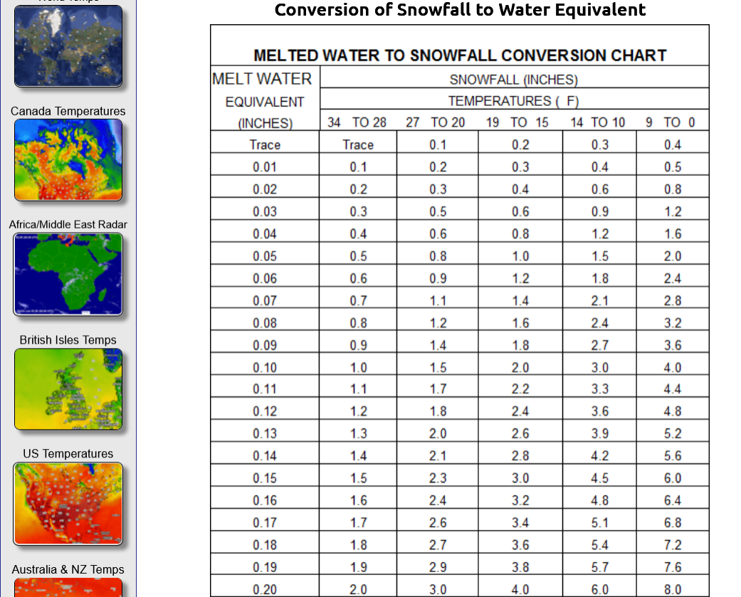
.20 = 4" snow
.30= 6" snow
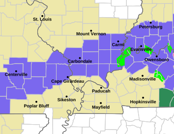
Winter Storm Watch up for this area!
WINTER STORM WATCH REMAINS IN EFFECT FROM TUESDAY MORNING THROUGH WEDNESDAY MORNING...
* WHAT...Heavy snow possible. Total snow accumulations between 4 and  9 inches possible.
* WHERE...Portions of southern Illinois, southwest Indiana, western  Kentucky, and southeast Missouri.
* WHEN...From Tuesday morning through Wednesday morning.
Get all the comprehensive weather here:
https://www.marketforum.com/forum/topic/83844/
Current Hazards at the link below.
Go to the link below, hit hazards box in the top right hand corner(it will also define all the color codes), if its not already in the hazards mode when you load the link.
Then you can hit any spot on the map, including where you live and it will go to that NWS with all the comprehensive local weather information for that/your county.
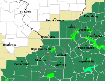
Snowfall in Evansville this morning: 3.2" was the high amount in Melody Hills. Very brief snow falling at an incredible rate, ~2 inches/hour.
https://www.weather.gov/source/crh/snowmap.html?sid=ilx
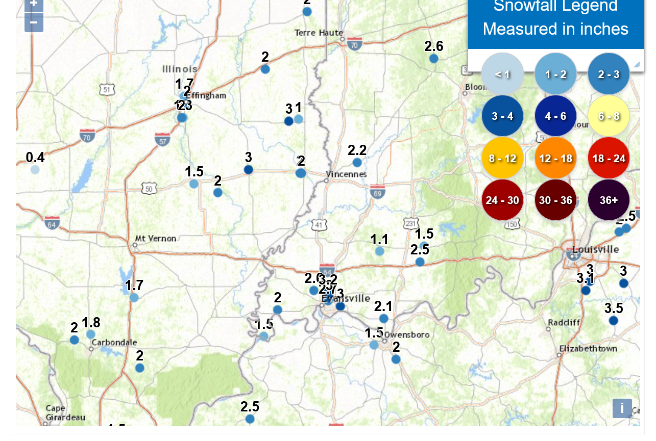
My wife and oldest son just told me that tons of people remarked to them (and hundreds on social media) that they were shocked at the 3 inches of snow that fell this morning in Evansville, IN since nobody predicted it.
But they knew it was coming as did readers here.
This was the forecast above:
Re: Re: Re: Re: New Winter Weather pattern 2-6-25
By metmike - Feb. 15, 2025, 3:06 p.m.
Snow amounts are going up in my forecast!
This is the last 12z GFS for Sunday. Will this much snow (4+ inches)happen??? Probably not but its a possible surprise.
The rest of the week below from the European model. This WILL change!
1. Sunday-2+ inches possible very early
2. Monday
3. Tuesday-snow starts very late evening in Evansville
4. Wednesday-5+ inches possible-heavier south
5. Thursday

+++++++++++
I won't gloat too much because being an operational meteorologist means accepting being wrong A LOT OF THE TIME for a living.
Additional weather thread from the NTR forum:
Blown Away
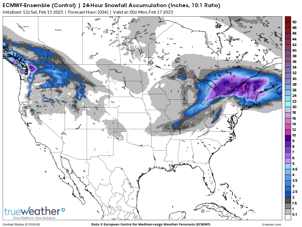
For this next storm, Tue PM into Wed AM. I've been REDUCING the snow amounts. The latest 0z guidance continues to shift the heavier amounts farther southwest of Evansville.
I'll wait for more model solutions but the 0z GEFS just took out a bit more snow. Maybe 2-4 inches in my update after seeing the European model that comes out in a couple of hours??
This was the just out 0z GEFS for total snow thru Thursday. For sure, the heaviest snows will be south of Evansville! This will be mostly an upper level system too.
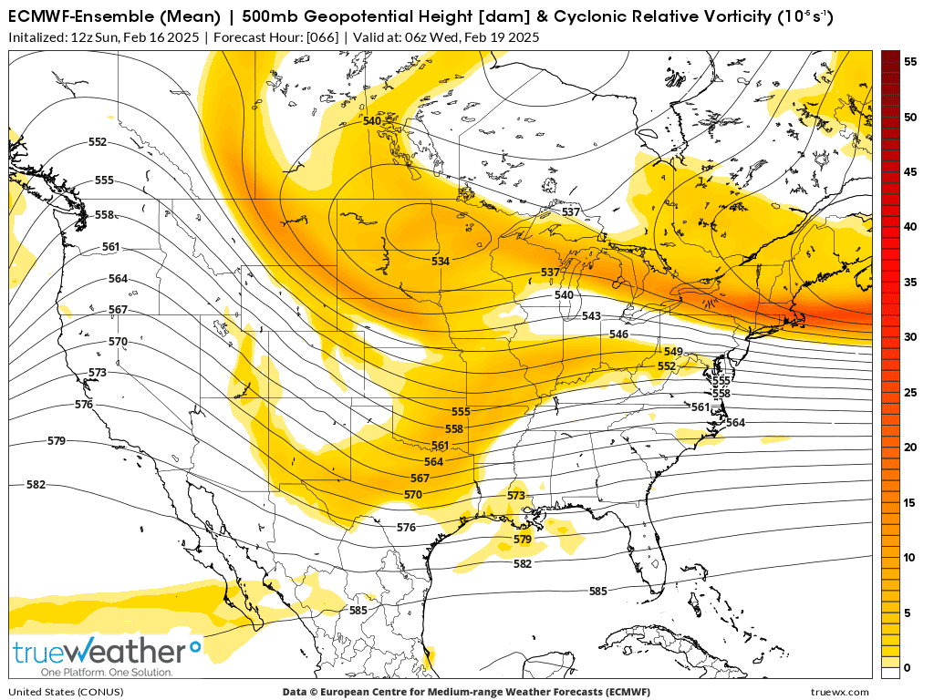
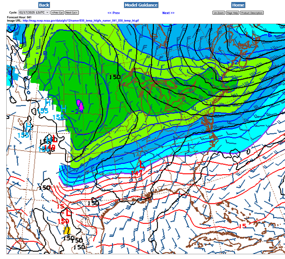
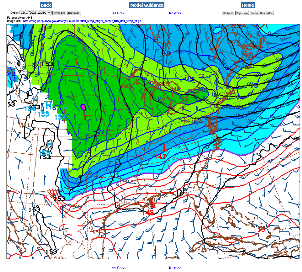
This is how it looks at 500 mb, very early on Wednesday. Yellow is vorticity/spin in the atmosphere that causes lift. We get a pretty good shot of that, even though the air is pretty dry and there is no added moisture coming in this far north.
Below: We can barely make out a very weak 850 low around midnight Wed morning over Memphis, TN. This is favorable for decent snows here, so I don't want to reduce amounts too much, too soon. It's a slight southward shift from earlier guidance on Sunday.
The latest guidance has been consistent with the LOWER snow amounts based on the forecast philosophy from late Sunday.
There are several tricky elements with this one.
1. We're on the northern edge of a steep snowfall gradient
2. The water equivalent is double the usual because of cold temps. Instead of 10 to 1, this will be 20 to 1.
3. No surface development, mainly upper levels. Not much moisture coming in. However, some of the solutions have a very weak 850 Low close to Memphis that, if it developed a bit could boost snow amounts.
12z models still updating. Not a great deal of change. Still thinking 2-4 inches right now but always with the mindset of "What could happen to cause a surprise" like the one that predicted Sunday morning's "surprise" snow.
In this case, a very subtle feature at 850 mb below after midnight on Tuesday Night. A tiny low pressure wave tracking at the southern edge of the below freezing(blue colors) steep temperature gradient below(in the TN Valley). It's pretty harmless as depicted but will likely generate enough convergence to boost snow amounts a bit south of us.
Models are often wrong with subtle features like this. If it intensifies more than expected, snow amounts might be MUCH more than expected(especially south of us).
The other possibility is that the massive weight and momentum south of this huge frigid blast could cause it to expand farther south than what the models think..........which would embed more colder and drier air in here during the event and shift EVERYTHING farther south, including the snow amounts. In that case less than 2 inches of snow would fall north of the Ohio River.
+++++++++++++++
Putting subjective % numbers on those ideas might look like this:
2-4 inches = 60% chance
4+ inches= 15% chance
Less than 2 inches = 25% chance
+++++++++++++++++
So the science of forecasting snow still has too many uncertainties, even with todays wonderful technology to always get it right.
We can get a ton of things exactly right. And be pretty close most of the time with snow amounts but something like the exact time and place of a tornado touchdown can't be predicted until the Doppler radar sees a specific circulation aloft that will cause it. ......less than an hour before hand.
Exact tornado paths will never be predicted the day before. NEVER! We know the conditions and can advise over a massive area of elevated risk to be watching and be prepared for it but until the radar shows it or an observer reports it........nobody knows the exact spots or if tornadoes will happen.
Interestingly, Hurricanes that are many thousands of times wider than tornadoes CAN be accurately predicted many days ahead of time in some cases. Technology may come up with a way to weaken them in the decades to come but not to stop/weaken tornadoes.
Or to weaken snow storms. Or to stop Arctic blasts or heat waves or droughts or excessive rain events. The enormity of the features and dynamics are much too great and would require a man made force and amount of energy that is impossible to conceive.
OK, back to the snow now
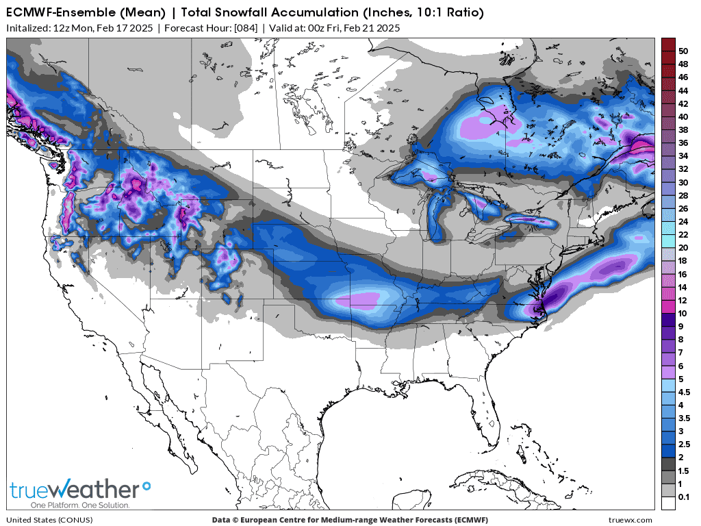
This was the last 12z European Ensemble model forecast. If we wanted to believe it exactly, then maybe just over 2 inches of snow for southwest IN. Almost all the solutions of all the models have converged on this solution. Normally, that reduces surprises and it always boosts confidence.
We started a new weather thread yesterday.
 Weather Map