Local Radar
Let's start a new thread so you don't have to scroll 5 miles down to get the last post
Get all the updated weather here:
https://www.marketforum.com/forum/topic/83844/
+++++++++++++++++
This was the previous thread:
New Winter Weather pattern 2-6-25
33 responses |
Started by metmike - Feb. 6, 2025, 10:23 p.m.
https://www.marketforum.com/forum/topic/109863/
+++++++++++++++
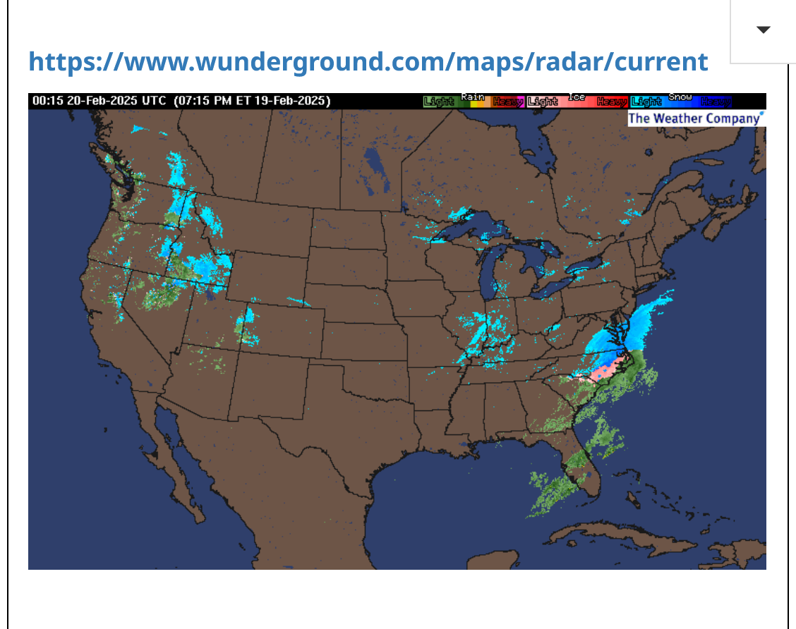
Current Hazards at the link below.
Go to the link below, hit hazards box in the top right hand corner(it will also define all the color codes), if its not already in the hazards mode when you load the link.
Then you can hit any spot on the map, including where you live and it will go to that NWS with all the comprehensive local weather information for that/your county.

https://www.wunderground.com/maps/radar/current

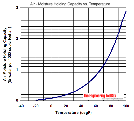
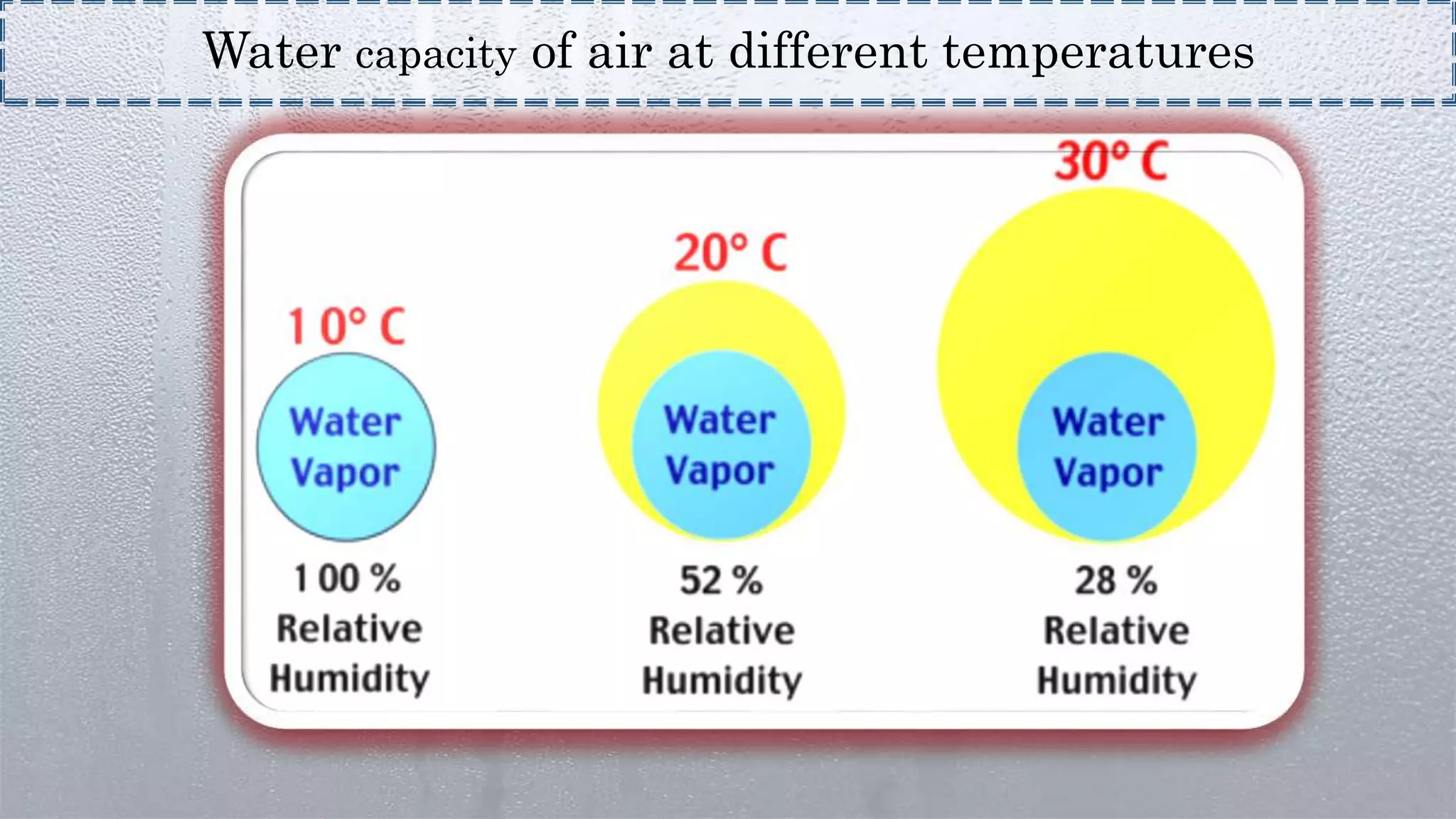
Most of our snows are close to a 1 inch water = 10 inches of snow. The air can hold more moisture with increasing temperature, so the closer it is to freezing, the more moisture an inch of snow will have
This one will be double that because this cold, drier air can only hold 50% of the moisture compared to the same temperature near 32 degrees.
If we get .2 water equivalent it can make 4 inches of snow when the temperature is just below 20 Deg. F.
+++++++++++
Despite the atmosphere being able to churn out more snow with less moisture in a colder environment, very cold environments are usually extremely dry. So the colder it gets, the less moisture the system has and the lifting dynamics which condenses out the snow from rising air are greatly suppressed because cold air is very heavy and hard to lift.
https://eldoradoweather.com/current/misc/snow-to-water.html
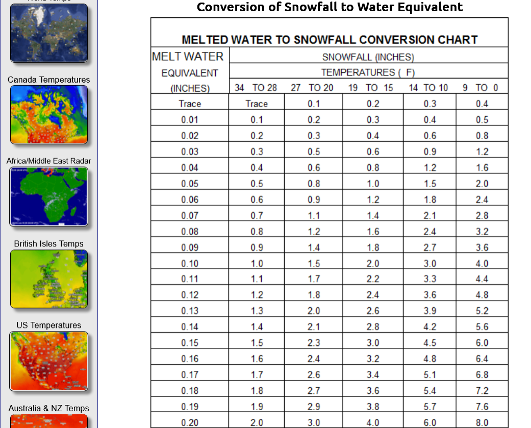
.10 = 2" snow NOT 1"
.20 = 4" snow NOT 2"
.30= 6" snow NOT 3"
++++++++++++++++++++++
https://www.engineeringtoolbox.com/moisture-holding-capacity-air-d_281.html
https://www.slideshare.net/slideshow/humidity-115920022/115920022
Paducah - KY, US, National Weather Service
Ohio River at Newburgh Dam
...FLOOD WARNING NOW IN EFFECT UNTIL WEDNESDAY, FEBRUARY 26... WHAT...Minor flooding is occurring and minor flooding is forecast. WHERE...Ohio River at Newburgh Dam. WHEN...Until Wednesday, February 26. ADDITIONAL DETAILS... - At 11:00 AM CST Monday the stage was 43.4 feet. - Forecast...The river is expected to rise to a crest of 45.7 feet early Saturday afternoon. It will then fall below flood stage Wednesday, February 26. - Flood stage is 38.0 feet. - http://www.weather.gov/safety/flood
...The Flood Warning is extended for the following rivers in Indiana...Kentucky... Ohio River at Owensboro, Newburgh Dam, Evansville, Henderson, Mount Vernon, J.T. Myers Dam, Golconda, Smithland Dam, Paducah, Olmsted Lock and Dam and Cairo. .Heavy rainfall over the weekend will continue to causes rises along the Ohio River through the week.
The warmer the air is.........the more buoyant it is. That's also why THUNDER snow is extremely rare(not enough lift to the air because its too cold). If you have thunder snow, you will often see 2-3 inches/hour because of the enormous lift.
Jim Cantore from the Weather Channel gets all pumped up from Thundersnow over Kansas City!
Re: Re: Winter weather ahead 12-30-24
By metmike - Jan. 5, 2025, 9:18 a.m.
I have experienced THUNDERSNOW only 2 times in my life. Dec 1, 1974 in Detroit during a 15+ inch snowstorm(3 days after Thanksgiving-University of Detroit was closed for 2 days)
https://www.weather.gov/dtx/GhostofThanksgivingWeekendSnowstormofthePast
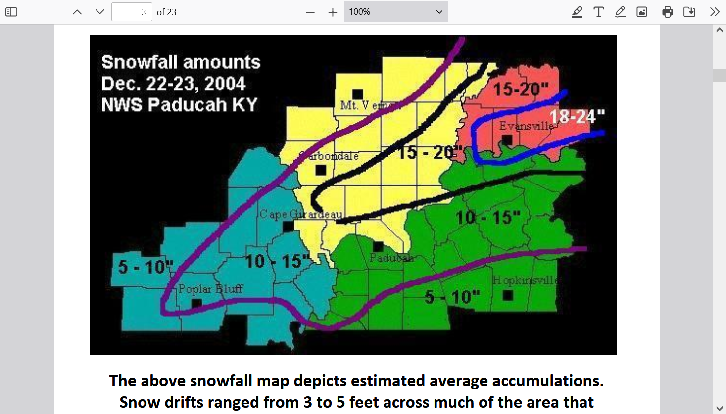
Then December 22, 2004 in Evansville during our 2 foot snowstorm. Anybody at least 30 today, that lived here remembers that one!
...Record snowfall up to two feet paralyzed much of the region...
Evansville - 22.3 inches (19.3" on Dec. 22 and 3.0" on Dec. 23). This storm set a new 24-
hour snowfall record, and made this the second snowiest December for Evansville.
Paducah - 14.2 inches. This storm set a new 24-hour snowfall record, and made this the
snowiest December for Paducah.
https://www.weather.gov/media/pah/Top10Events/2004/Dec22_2004Snowstorm.pdf
https://en.wikipedia.org/wiki/Thundersnow
There is a 0% chance that this Winter storm will have thundersnow.
1. Too cold
2. Not strong enough dynamics to create tremendous lift
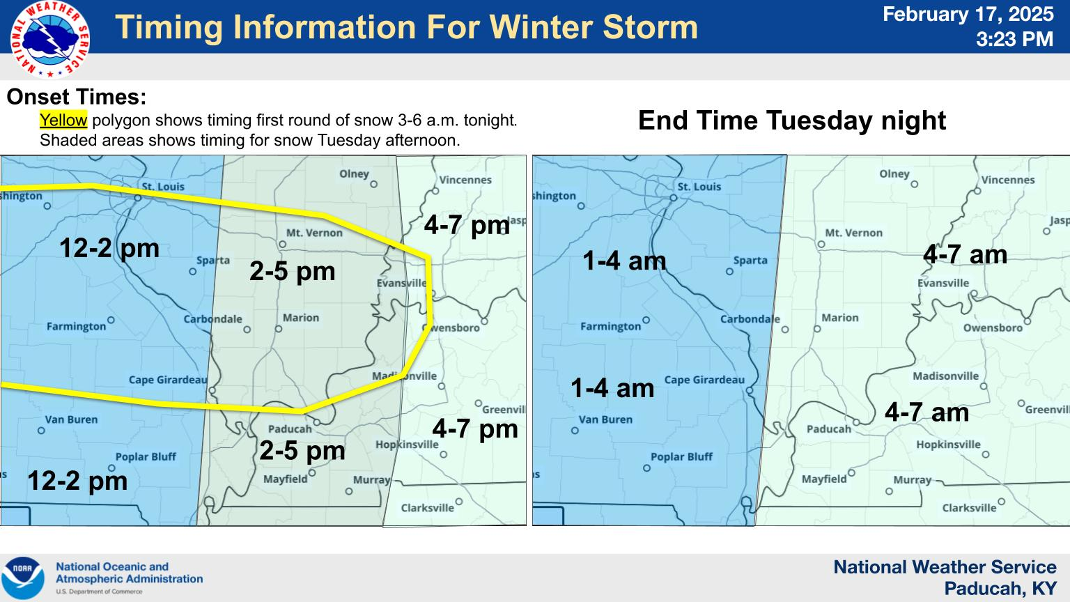
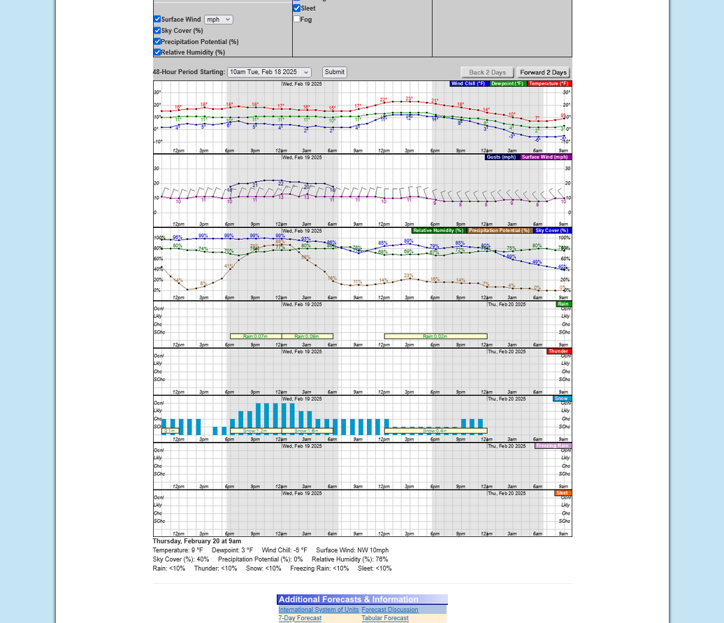
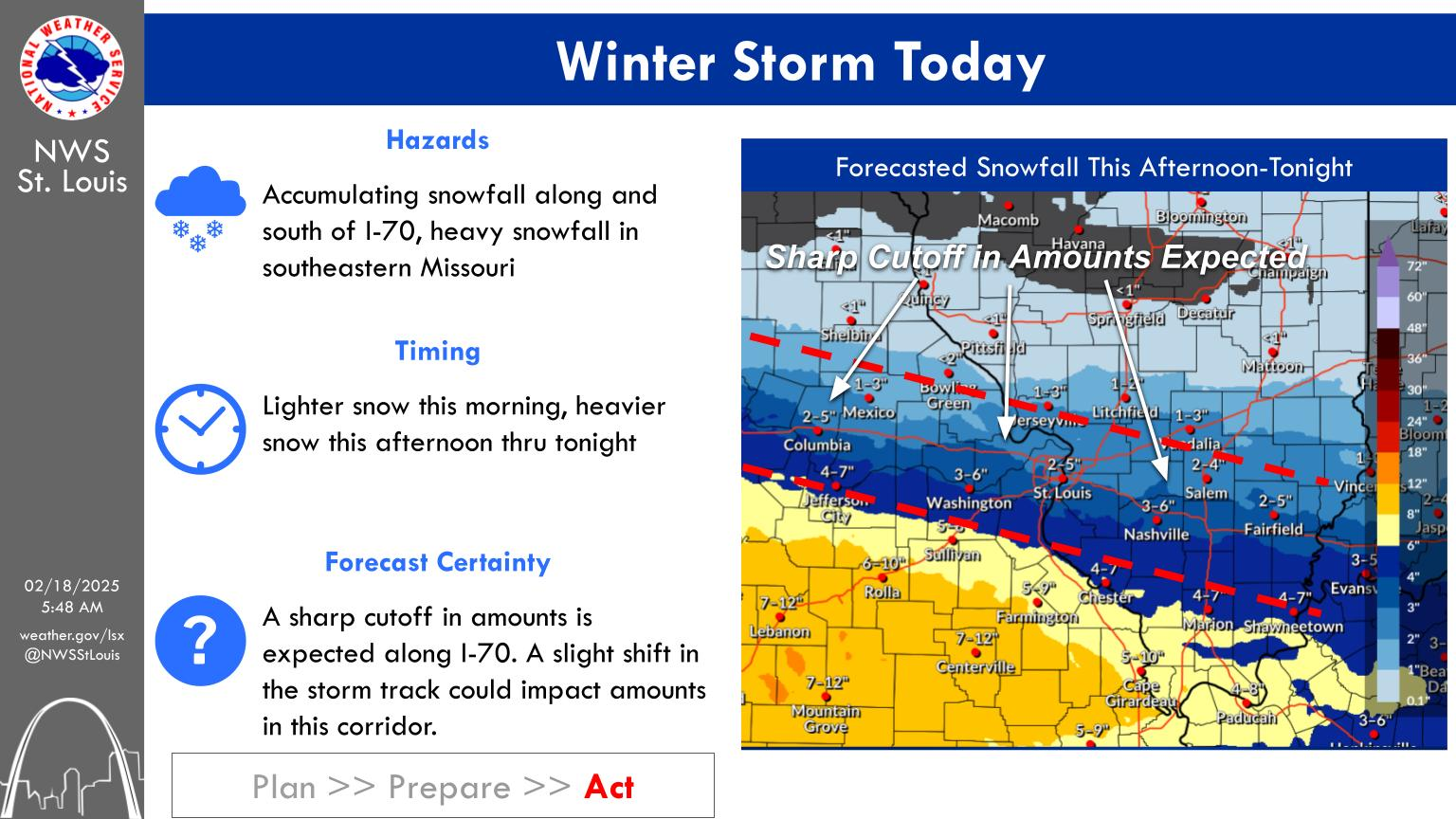
Some light snow developing ahead of the main system sneaking in here! This is not unexpected as we can see on the numerical graph at the bottom. Amounts should be pretty light but with temperatures this cold, its likely to cause slick spots on the untreated roads.
The
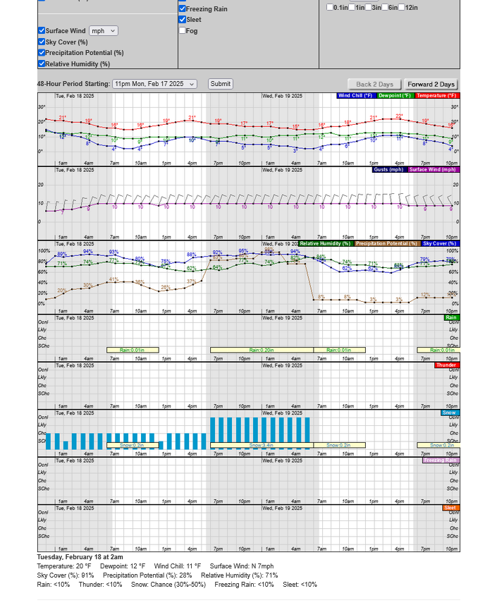
The computers numerical guidance totals out 3.8 inches of snow above. It's often pretty close but on Sunday Morning, when we had 3.2 inches of snow, the numerical guidance had .4 inches(less than 1/2 inch).
I thought it might be predicting much too light a day earlier. This time, it may be a bit too heavy.
Let's stick with the previous forecast:
Putting subjective % numbers on those ideas might look like this:
2-4 inches = 60% chance
4+ inches= 15% chance
Less than 2 inches = 25% chance
+++++++++++++++++
This was the last 0z GFS model forecast snow this week:
++++++++++++++++++++
BTW, the GFS 12z Saturday run below was the only operational model run that captured the Sunday morning (surprise to most) snow event!
Re: Re: Re: Re: New Winter Weather pattern 2-6-25
By metmike - Feb. 15, 2025, 3:06 p.m.
Snow amounts are going up in my forecast!
This is the last 12z GFS for Sunday. Will this much snow (4+ inches)happen??? Probably not but its a possible surprise.
The rest of the week below from the European model. This WILL change!
1. Sunday-2+ inches possible very early
+++++++++++++++++++
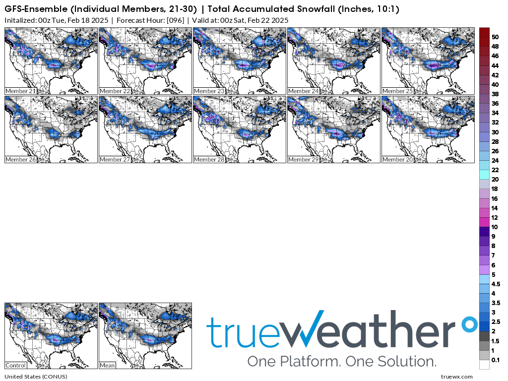
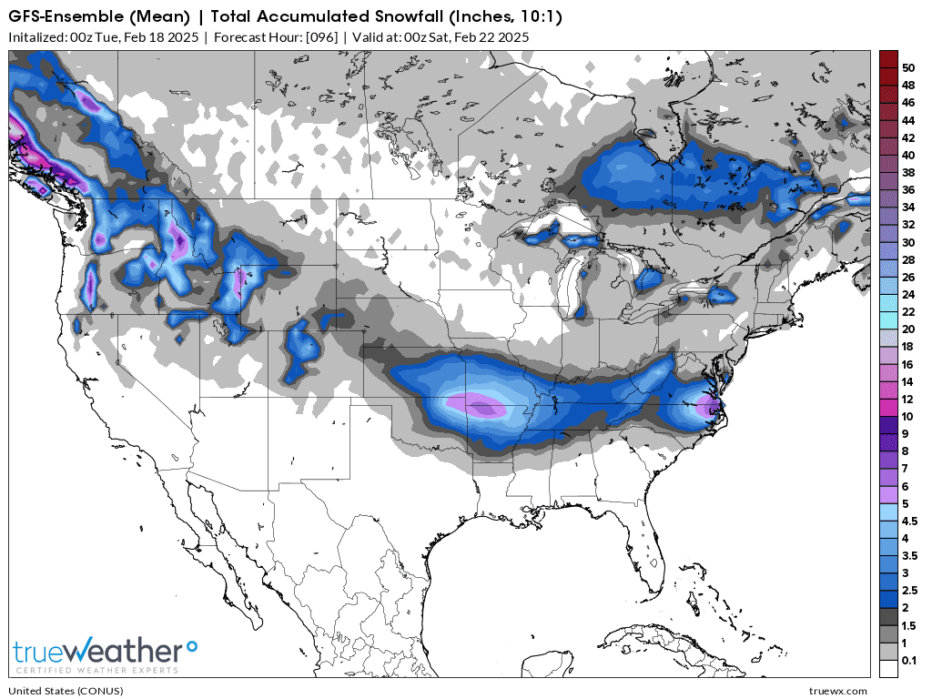
This does NOT mean the GFS is a superior model. It just means that models are imperfect and each model uses slightly different equations. Each model has numerous individual solutions (European model has 50 of them). Each individual ensembles member has a slight tweeking in 1 parameter to see what happens, since there is no PERFECT model with all the perfect equations.
After all the different members are averaged together, we get the ensemble average that consistently has the best skill in the long run because it averages out all the extremes of the individual solutions.
Let's show that to you with this last 0z GEFS, which are the ensembles of the parent, operational GFS model above.
1. 30 different, individual GFS-Ensemble solutions. Several have almost no snow for Evansville. Enough for this to NOT just be an outlier solution but for me to think this is a possibility.
2. The average of all of them is a bit LESS THAN 2" of snow. This is part of the reason that I have less than 2" at 25% but more than 4" is only 15%. The actual forecast is 2-4" but there's a greater chance for LESS than the chance for more than that range.
Based on the models consistently reducing amounts very slightly on each,of the last 3 runs, especially this just out 6z run, I’m lowering forecast snow amounts down a bit to 1 to 3 inches, here at 5 AM.
There WILL BE heavy snow from this Winter storm but it wI’ll likely ALL be south and especially southwest of Evansville.
1-3 inches 60%
1 inch or less 20%
4+ inches 20%
++++++++++++++
The latest forecast is adding another inch during the day and evening Wednesday to this forecast above.
The time stamps on MarketForum are in Eastern Time, 1 hour ahead of us.
OK, this moderate snow band that is coming thru was a bit more than expected (but was mentioned last night) but thats the thing with snow in this cold air (17 degrees) it takes only half as much moisture to make the same amount of snow.
It takes only .05 in liquid equivalent at the current 17 degrees to make an inch of snow.
https://www.marketforum.com/forum/topic/110033/#110034
So the atmosphere may have just used .03 or .04 worth of moisture to make just under an inch of snow. When the main system is not even directly impacting us right now, its literally impossible with today's technology to predict with pinpoint precision, that exactly .04 worth of moisture will condense out a day in advance instead of .01 or .02........or even nothing. Regardless, this is expected but with a bit more than I would have GUESSED.
So the latest computer generated numbers have a new twist that makes sense based on the meteorology.
The snow will NOT come to an abrupt ending early on Wednesday......after the main event. There will continue to be snow showers thru Wednesday evening, possibly until after midnight. Based on the meteorology of the upper level system, I feel pretty confident in additional, periods of snow showers THRU Wednesday. The numerical guidance yesterday completely missed this, just like it missed the early Sunday snow. That happens sometimes.
With that in mind and with the snow that fell this morning, I have to adjust the TOTAL snow amounts back up to at least 2-4 inches and to also increase the chance of 4+ inches too.. Welcome to the world of operational meteorology weather forecasting
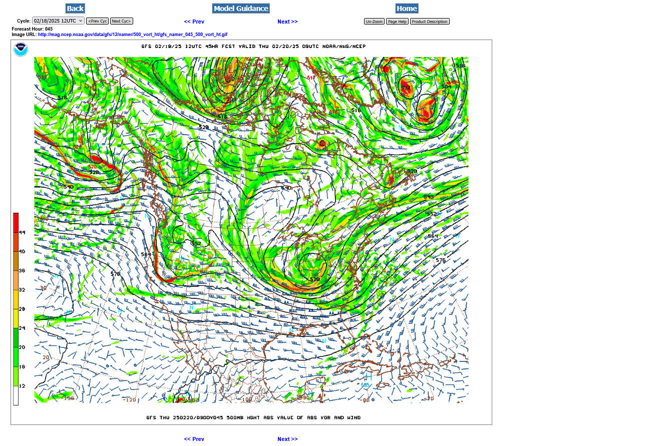
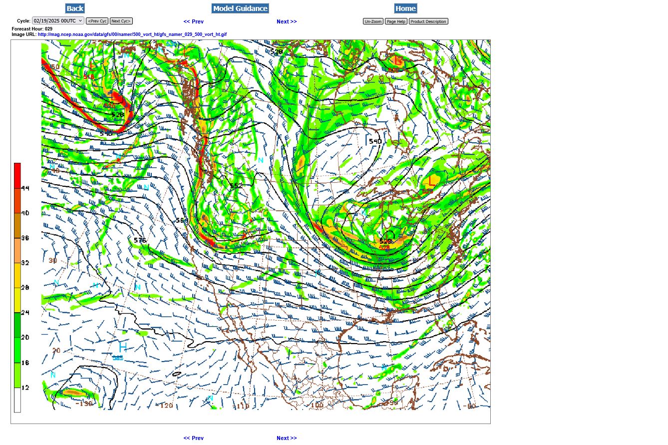
This is the 500 mb map for late Wednesday, then very early Thursday.
With the deep, cut off upper level low in that position and that much vorticity(spin/lift) coming thru in pieces there is no way there will not be a continuation of significant snow showers well into Wednesday Night. Additional minor accumulations are LIKELY.

+++++++++++++
Noon: The NWS measured .02 in water equivalent from that snow but it was probably a bit more. Regardless, if it was rain in the Summer that amount might not completely wet the ground below a thick canopy of trees.
Looks like most of that is over and we wait for the main event, starting this evening.
The biggest change in the forecast this morning was to add another inch of snow showers to the Wednesday DAYTIME forecast from upper level dynamics. This extends the ending time of the snow(showers) until, possibly just after Midnight Wednesday Night.
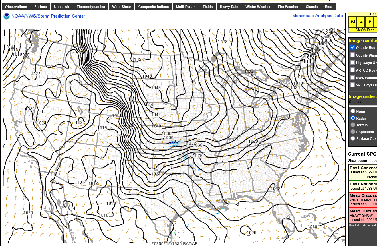
Look at the massive Arctic high coming down right now!
https://www.spc.noaa.gov/exper/mesoanalysis/new/viewsector.php?sector=19&parm=ttd#
1. snap shot just after noon
2. Live updated constantly

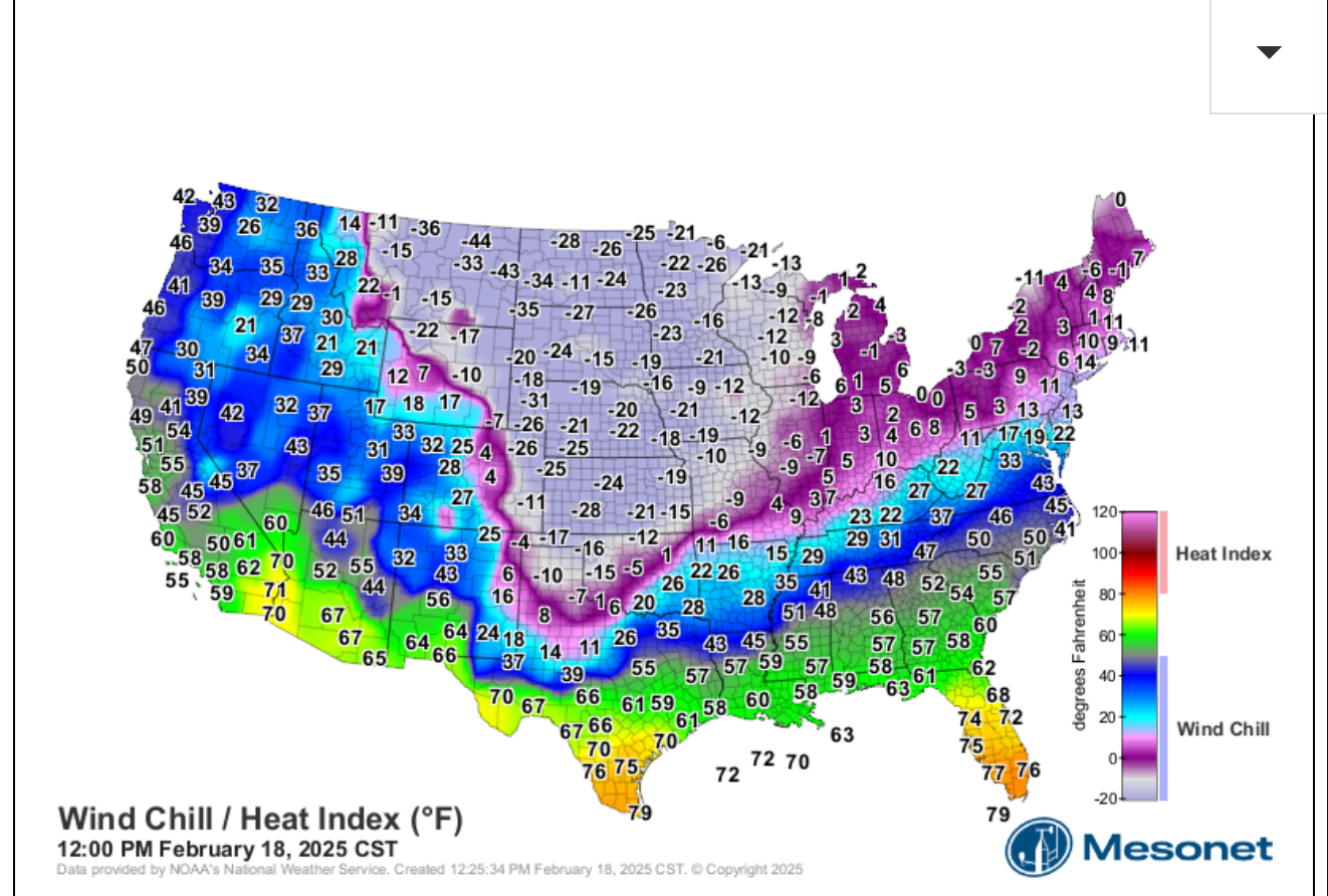
Windchills:
1. Freeze frame just after noon 2-18-25
2. Live
All the heavier snow bands are setting up SOUTH of Evansville so far. At this rate, it's going be tough to get over 2 inches from the main event this evening.
I think the main event ends, maybe an hour or 2 after midnight with flurries possible and a long lull thru most of the morning before snow showers return Wednesday afternoon and continue until close to midnight with minor additional accumulations Wednesday PM.
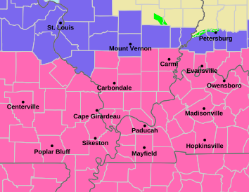
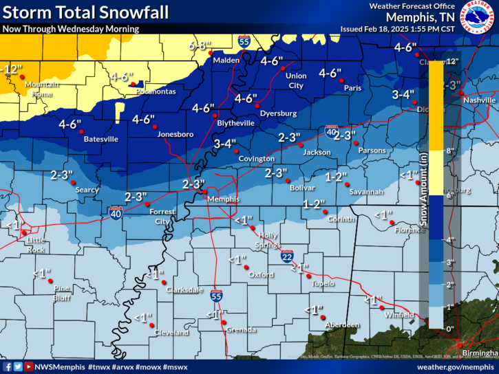
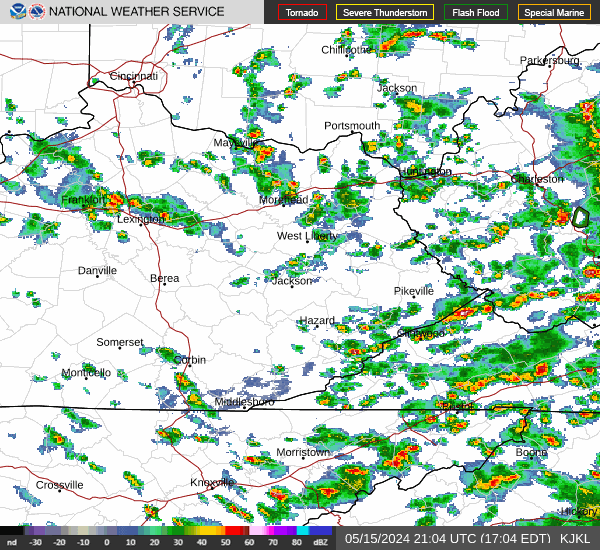
Paducah radar below:
That's probably sleet in the yellows and red on the radar around Memphis.
Here's what Memphis has to say:
 +
+
++++++++++++++++++++++++++++++++
Little Rock NWS
The heavy snow band south of the Ohio River is showing up

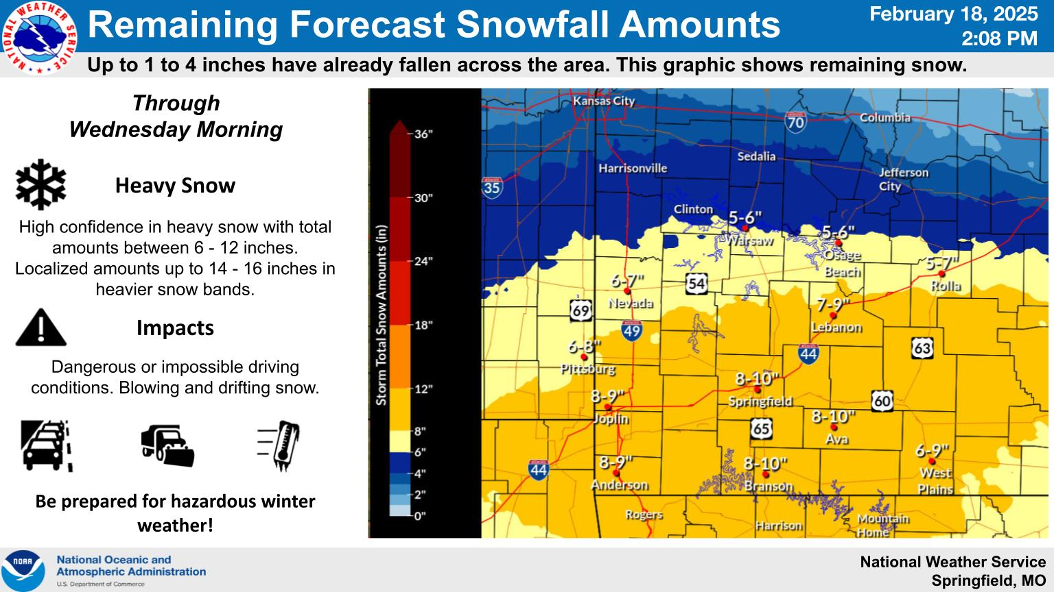
Farther west, Springfield, MO. They get the heaviest snow!

ST. Louis: Mostly south of them!

To the east: Louisville:
https://www.weather.gov/lmk/weatherstory


Cincinnati:............It passes mainly south!!
Jackson Ky:
10: 40 pm CST: Almost 3 hours since statement below and nothing has changed, so it's copied again with the radar image for convenience at the bottom of this thread.
Re: Re: Re: Re: Re: : New Winter Weather thread 2-17-25
By metmike - Feb. 18, 2025, 9 p.m. EST
All the heavier snow bands are setting up SOUTH of Evansville so far. At this rate, it's going be tough to get over 2 inches from the main event this evening.
I think the main event ends, maybe an hour or 2 after midnight with flurries possible and a long lull thru most of the morning before snow showers return Wednesday PM.
+++++++++++++
10:50pm: DO look for some minor accumulating snow showers returning late tomorrow, until around midnight. The reason for the snow to return is seen on this upper level map below, just before midnight on Wednesday. I would not be shocked to see over an inch in a few spots Wednesday evening.
The yellows and especially oranges are strong perturbations/lobes of positive vorticity rotating around what is a piece of the very southward displaced polar vortex, seen as a cutoff upper level low in westcentral Indiana on the map below.
This positive vorticity advection causes cyclonic(counterclockwise) spin and lift. It's strongly associated with areas of precipitation.
The models are very often deficient in recognizing the impacts of an area of positive vorticity( especially, well after the main system has passed-with no surface reflection), traveling parallel to the upper level streamlines like the one aimed at us late Wednesday.
Study hard on the tutorial below for the test on vorticity tomorrow night
http://www.theweatherprediction.com/habyhints/56/
Actually, for fun we can come back to this Wednesday evening and compare it to the radar images to see if it had the predicted impact just described. If not, then you can cut my pay in half!
The snow from the main system ended around midnight. Looks like just over 2 inches here.
https://www.weather.gov/source/crh/snowmap.html?sid=ilx
Despite sunshine and no snow for hundreds of miles, I still expect minor accumulating snow to return late today for the reasoning on the previous page!
1. 9:35 am radar-snow is 200 miles east
2. Live radar- waiting for late PM snow to develop and take aim at us.
3. Radar image from after 6pm. New snows showed up exactly as expected. Amounts are very light.
https://www.marketforum.com/forum/topic/110033/#110056
+++++++++++++++++++
Late morning snapshot below.+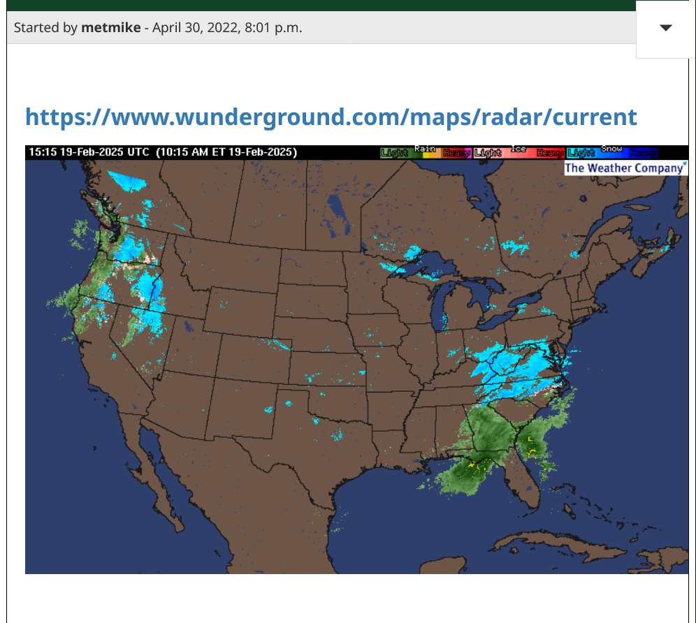
+++++++++++++++++++++++++++
Live radar below
https://www.wunderground.com/maps/radar/current
+++++++++++++++++++++++++++++++
Early evening snapshot below:
Blown Away
Started by mikempt - Feb. 16, 2025, 5:11 p.m.
https://www.marketforum.com/forum/topic/110007/#110061
Isobars and wind chills on Wednesday morning:
Tracking the expected new snows this evening. Likely LESS THAN an inch.
https://www.weather.gov/pah/Feb18-19_2025Snow
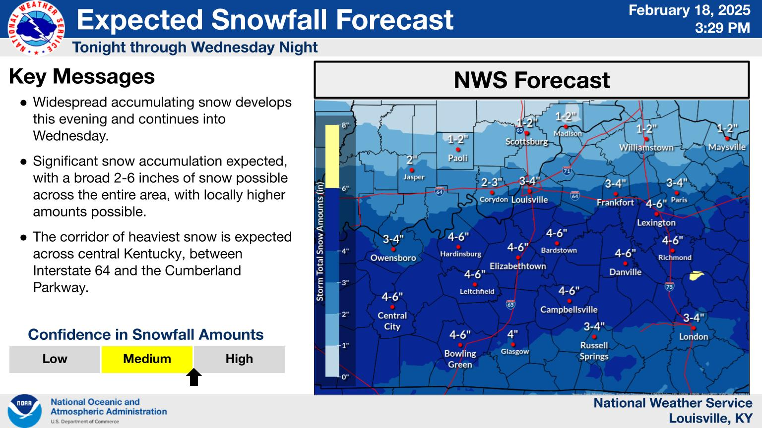
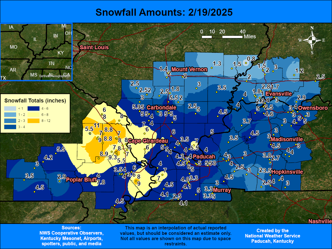
Overview
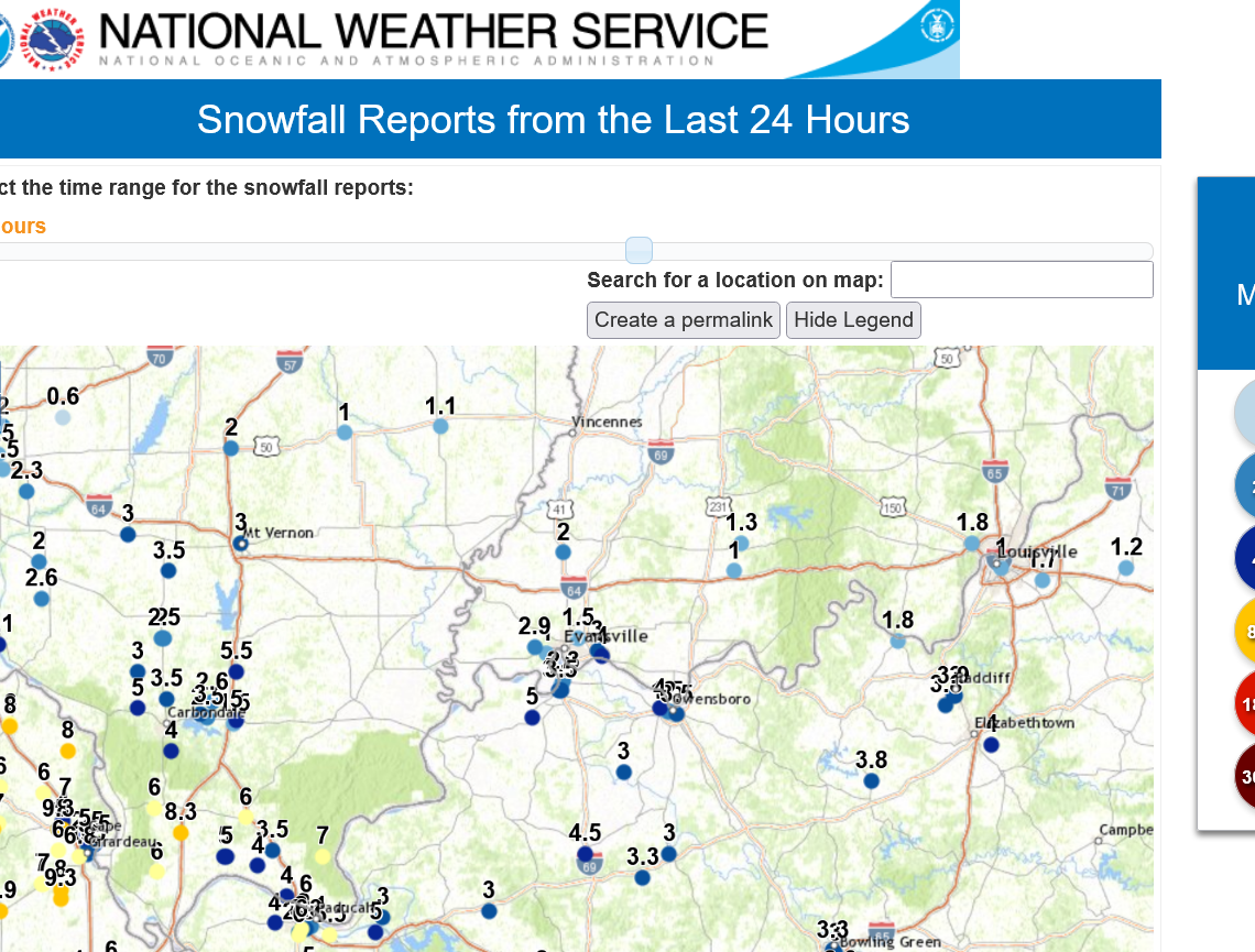
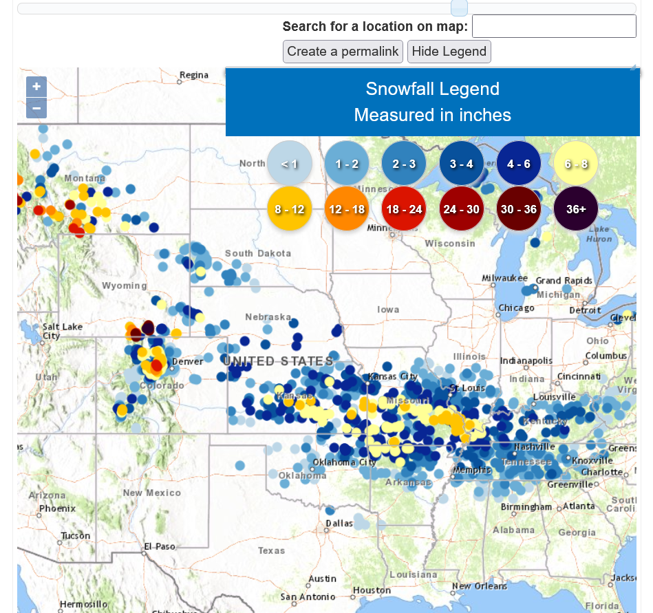
Right on the heels of a major flooding event, which produced rainfall amounts of 2 to 7 inches on February 15th, the area was transformed into a winter wonderland as snow quickly spread across the area on the afternoon and evening of February 18th. Roads quickly became snow covered due to temperatures only in the teens to low 20s. Parts of I-57 and I-24 were briefly closed overnight due to poor road conditions and accidents. By the morning of the 19th, most of our region had received anywhere from 3 to 8 inches of snow, and localized higher amounts up to 11 inches were observed in southeast Missouri. Wind gusts around 25 mph also accompanied the event, leading to some blowing and drifting of the snow which made measuring it a bit of a challenge.
Snow
The map below is an interpolated graphic using local storm reports. Amounts of 3 to 8 inches occurred across much of the region except along and north of I-64 where only 1 to 2 inches were observed. The highest amounts were focused across southeast Missouri into far southern Illinois where localized higher totals up to 11 inches were reported. Cape Girardeau was among the hardest hit areas with 6 to 8 inches in and around the city. The official snowfall total in Paducah was 4.3" and Evansville was 2.3".
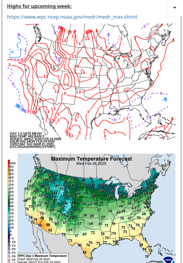
It will feel like Spring this week!!!
Wednesday will be the warmest!
https://www.marketforum.com/forum/topic/83844/#83851