This is a continuation of the previous thread but will focus entirely on this major storm. There will be dozens of additional posts updated in a timely manner.
I will be flying to Detroit at 5am Saturday, then driving back Saturday afternoon in my recently deceased dads car, so the updates will pause, starting very late Friday.
Previous thread:
Windbag Storms! 3-5-25
Started by metmike - March 6, 2025, 1:41 a.m.
https://www.marketforum.com/forum/topic/110314/
All the comprehensive, constantly updated weather here:
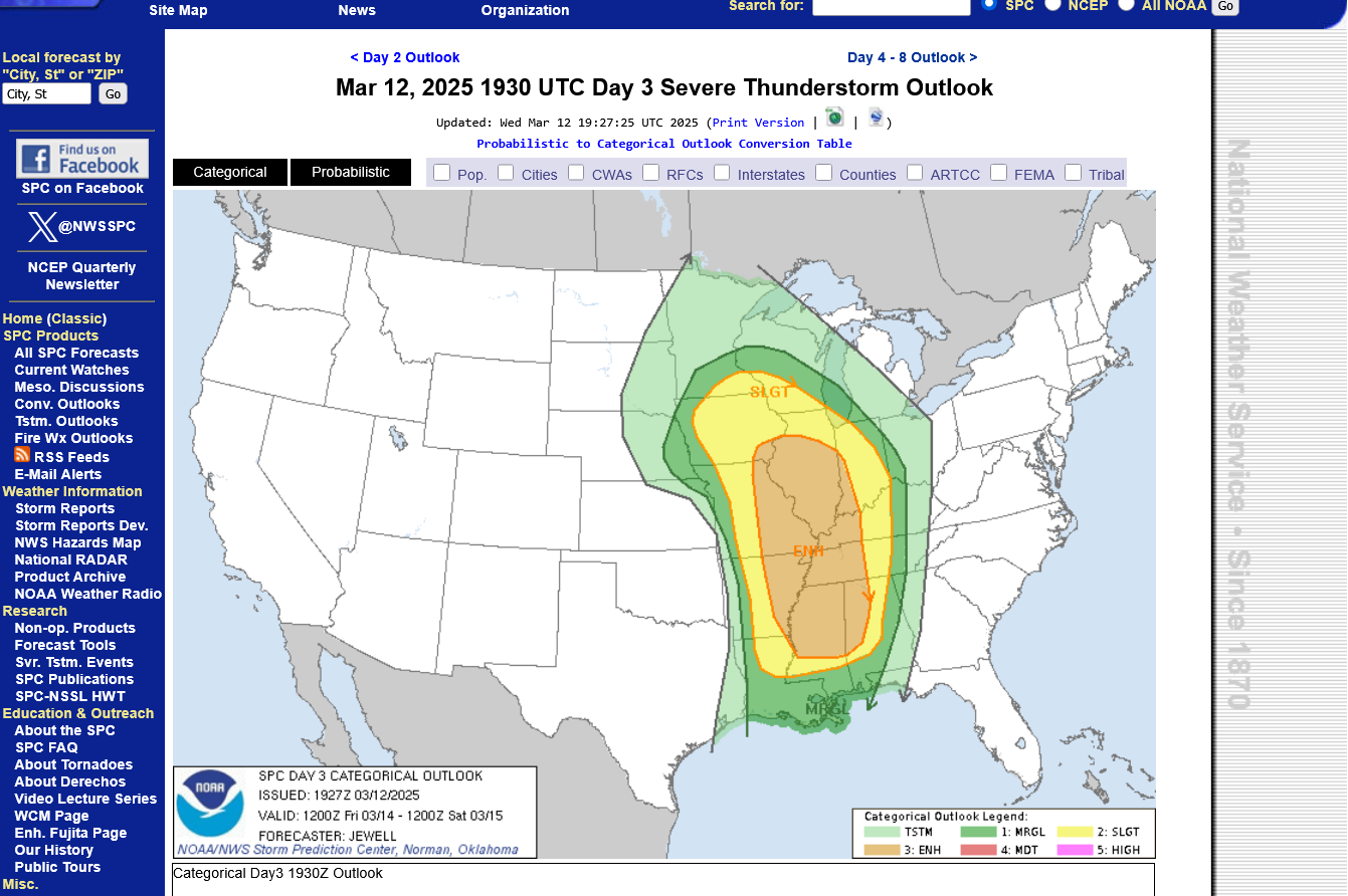
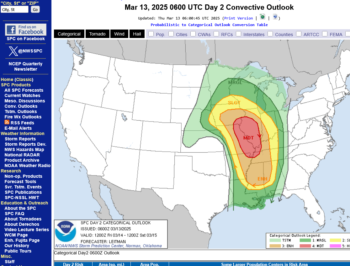
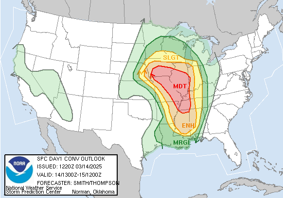
Latest day 3 outlook. This will be updated when it becomes day 2 and probably have at least MODERATE risk which is the 2nd highest. The Storm Prediction Center will have increased confidence as we get closer with specific dynamics that cause high end severe weather events showing up more clearly in the shorter time frames :
9pm: This map was updated slightly this afternoon compared to the early morning one below it. A slight expansion of both slight and enhanced colors resulted. This is typical. I'm thinking they may add the next level up tomorrow(moderate), in dark red.
https://www.spc.noaa.gov/products/outlook/day3otlk.html
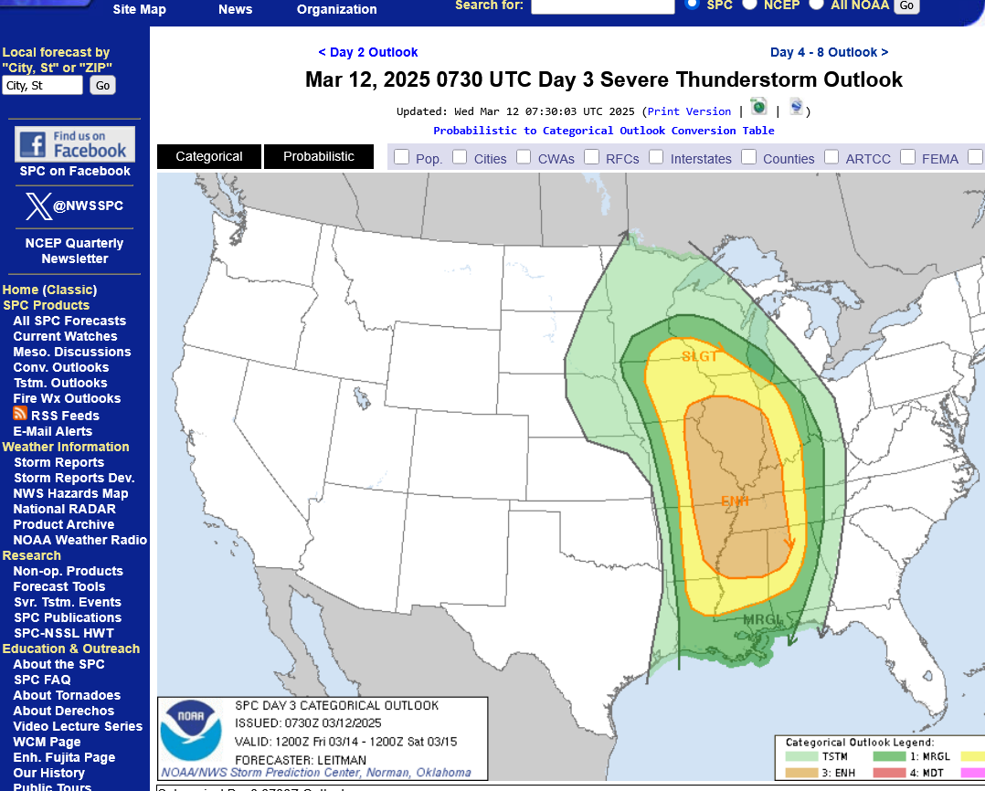
Wednesday afternoon:
Wednesday morning outlook below:
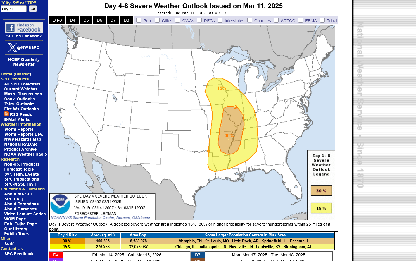
This was yesterday's day 4, Tuesday risk:
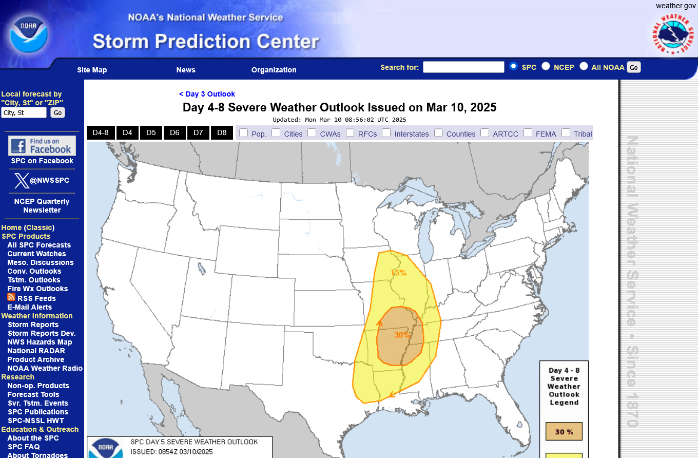
This was the previous day's day 5, Monday risk:
This is the surface pressure forecast from the 18z GEFS for around midnight, Friday Night.
The very tight pressure gradient means very strong winds from the south on Friday into Saturday on the front side of the deep surface low.
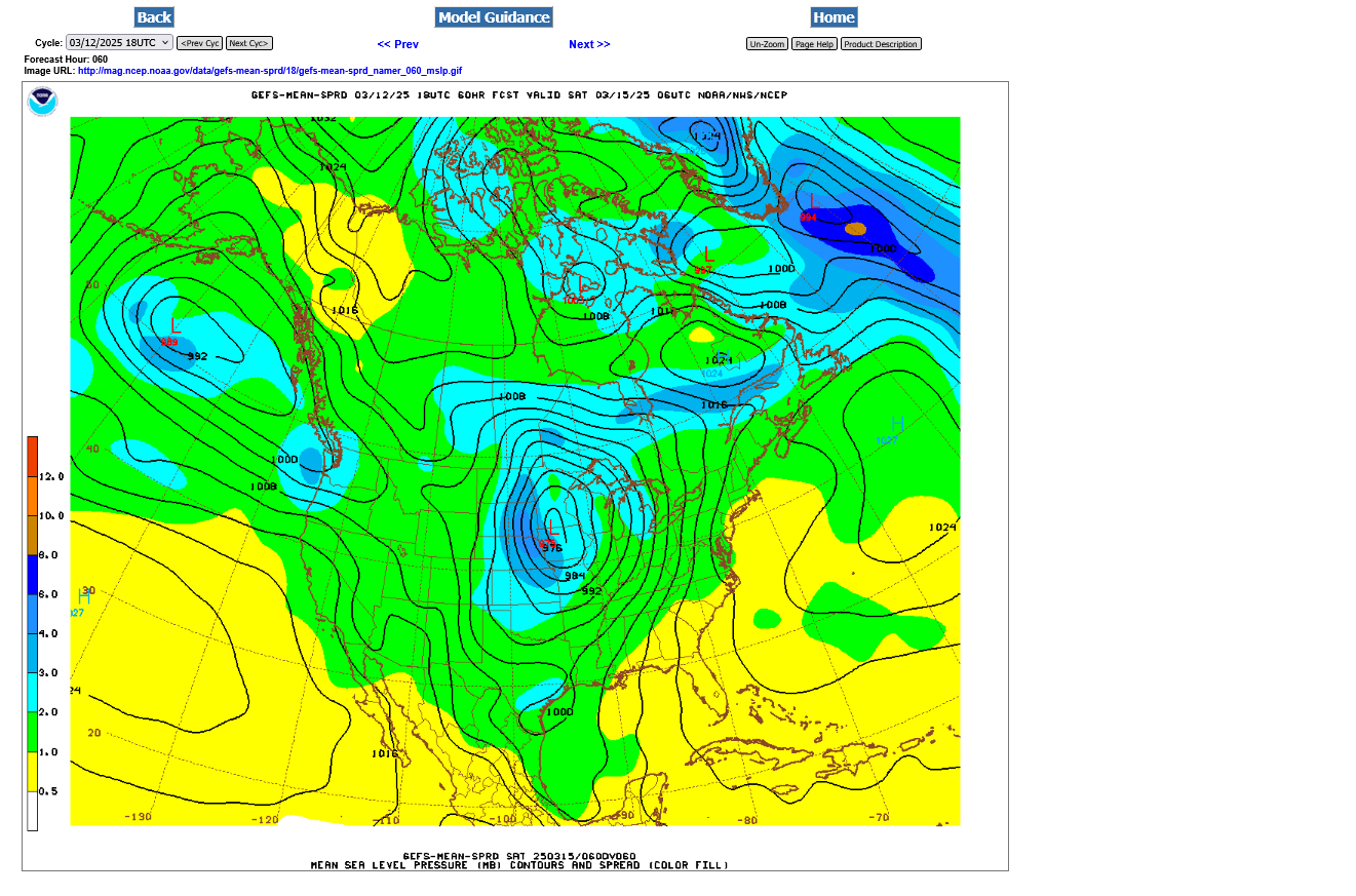
A line of strong storms will develop way ahead of the cold front(the cold front won't go thru until Saturday afternoon). They will be approaching around this time frame/midnight Friday or possibly going thru.
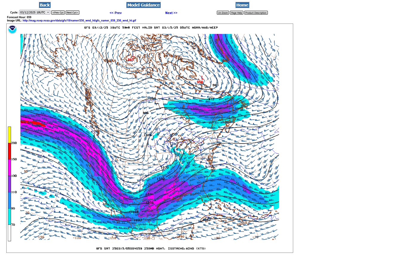
The approaching upper level jet stream at 250 mb(32,000 feet-where the jets fly) will be pretty strong and contribute greatly to the lift, along with rotation for tornadoes but not the most powerful this far north.
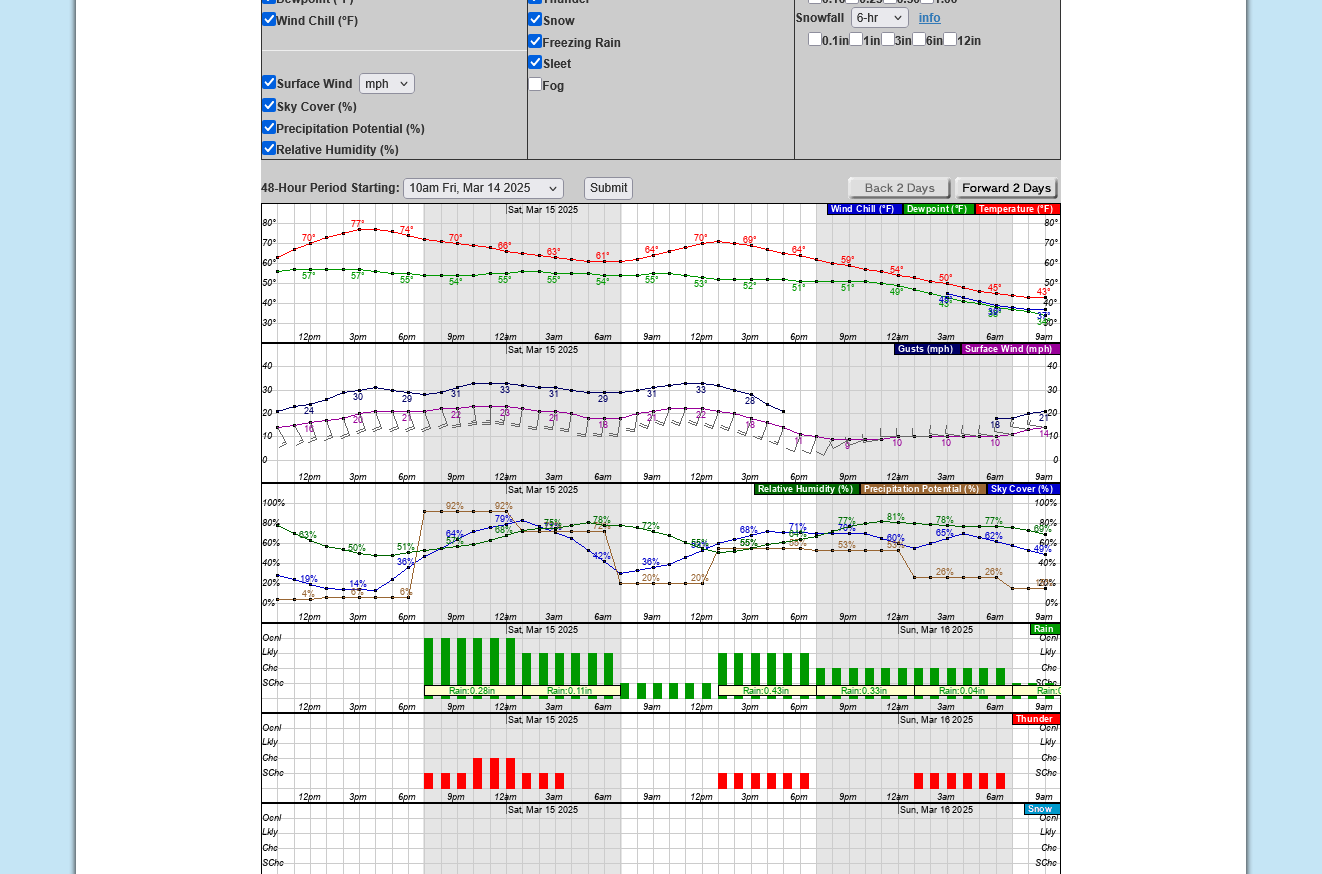
This is the NWS office for the Evansville area:
Hourly weather graph from 10am Friday to 10am Sunday:
The first line of storms will NOT be caused by an approaching cold front, like we usually see. More like a perturbation rotating around the front side of the deep low pressure with a surface reflection in the form of a trough. These storms should weaken overnight as they head east.
That possible line of storms will go thru around midnight........but winds will remain southerly, slowly shifting to the southwest after that.
Another round of storms is possible Saturday afternoon with another perturbation rotating around the surface low with the actual cold front not coming thru until late in the day.
As expected, the storm prediction centers day 2 outlook has a large area of moderate risk.
This area and the greatest risk will be Friday afternoon and evening until around midnight to the southwest of Evansville.
The severe storms will be weakening overnight Friday as they track northeast across Indiana.
However, they could still be severe when they hit the southwest part of the state around midnight.
Let's just show the link and LIVE version of these products so the updates will be automatic now.
Re: Re: Re: Re: Re: Weather May 2022
By metmike - April 30, 2022, 8:35 p.m.
Severe Storm Risk......updated daily(days 1 and 2 twice daily).
https://www.spc.noaa.gov/products/outlook/
Current Day 1 Outlook | |
Current Day 2 Outlook | |
Current Day 3 Outlook | |
Current Day 4-8 Outlook |
This was the map from earlier this morning:
I need to add something for perspective, especially for people that get a tremendous amount of anxiety ahead of events like this.
The chances of you being killed in a car crash are MANY time greater than dying from a violent tornado. In fact, only a very tiny portion of tornadoes are violent tornadoes that kill people. If you live in a home with a foundation(not a mobile home) and stay away from windows, even if the most severe storm and most tornadoes hits, you will be ok.
Lots of damage to the exterior of your house and property but you will be ok. If you go to a basement, your chances of surviving even a violent tornado are pretty good. We almost always know when a violent tornado is on the ground with todays technology!
If you didn't pay any attention to watches and warnings, you'd probably do just fine........like people 100 years ago were. If you DO pay attention to warnings, odds greatly increase of you doing just fine if the minuscule chance of a violent tornado hits YOUR house.
One of the problems in today's world is information overload that includes sensationalizing with massive amounts of visuals that include damage from severe storms and horrific scenes of the aftermath of a violent tornado that impacted .000001% of the population.
But we can get into our cars any drive around all day with no fear of being killed in a car crash. Just put on the seatbelts and have no fear because its an ACCEPTED RISK and we don't constantly have videos on our screens showing every car crash along with gory details of the injuries and deaths. If broadcast media did that..........then people would acquire a fear of driving in a car like some people have a phobia of severe weather.
The other thing is the complete loss of control.
In a car, we are in control. Defensive drivers can avoid accidents.
With severe weather, we can have the same sense of control. Track the weather and understand how minuscule the chances are of YOUR house being hit. Like with wearing a seat belt, when a TORNADO WARNING is issued.....go to the center of the house on the first floor, maybe in a small bathroom or even better to a basement if you have one.
If you don't, the same thing will probably happen to you than if you do in 99.9999% of cases. Severe storms will NOT kill you in the center of a permanent structure. Neither will weak tornadoes, which are most of them.
However, the rare VIOLENT tornado does kill people. If you are in your safe place, it's empowerment to be protected like wearing a seat belt.
https://www.census.gov/popclock/
| 17:28:51 UTC | |
| One birth every 9 seconds | |
| One death every 10 seconds | |
| One international migrant (net) every 23 seconds | |
| Net gain of one person every 19 seconds |
TOP 10 MOST POPULOUS COUNTRIES (July 1, 2025)
| 1. India | 1,419,316,933 | 6. Nigeria | 242,794,751 |
| 2. China | 1,407,181,209 | 7. Brazil | 221,359,387 |
| 3. United States | 342,034,432 | 8. Bangladesh | 170,183,916 |
| 4. Indonesia | 283,587,097 | 9. Russia | 140,134,279 |
| 5. Pakistan | 257,047,044 | 10. Mexico | 131,741,347 |
++++++++++++++++++++++++++++++++++++
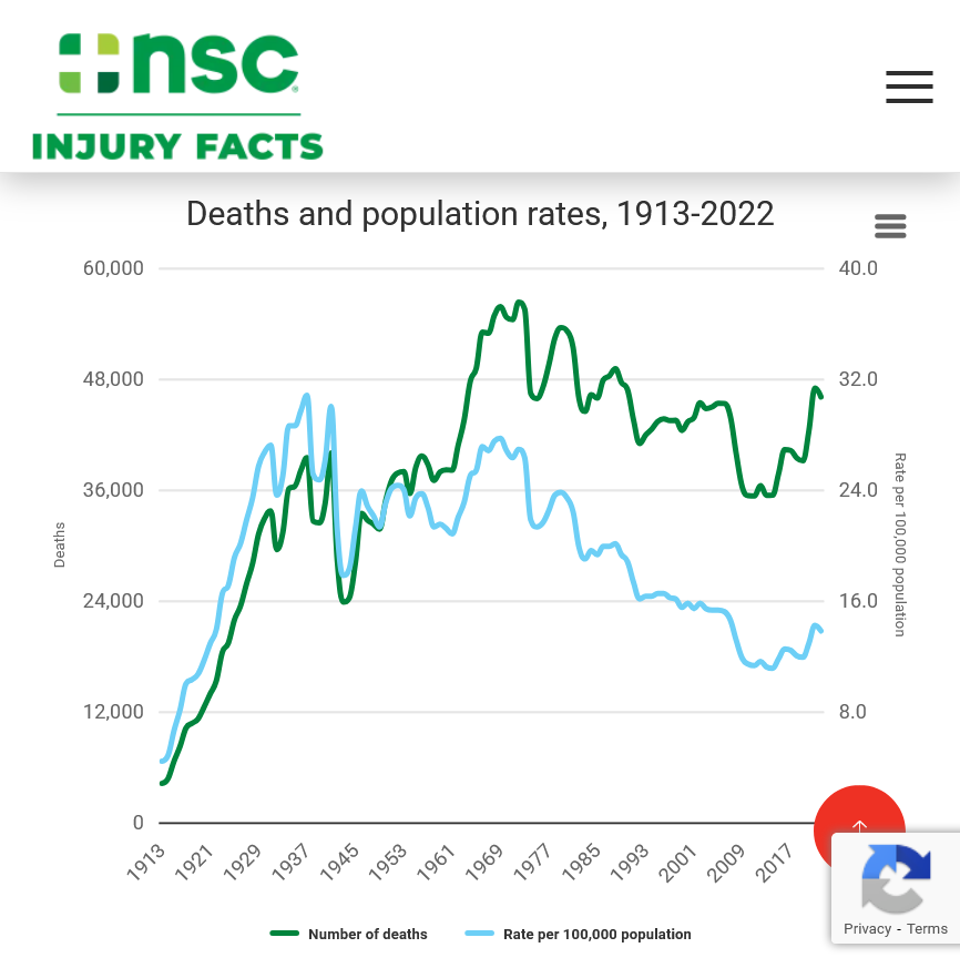
https://injuryfacts.nsc.org/motor-vehicle/historical-fatality-trends/deaths-and-rates/
++++++++++++++++
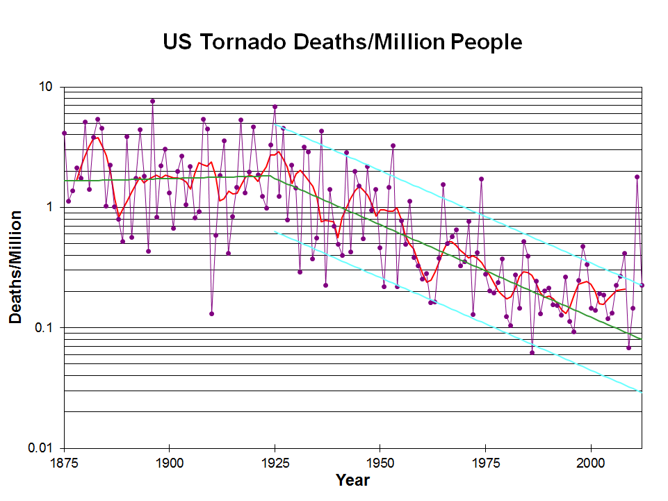
https://inside.nssl.noaa.gov/nsslnews/2009/03/us-annual-tornado-death-tolls-1875-present/
+++++++++++++++++++++++++++
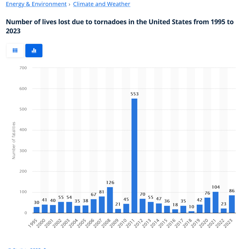
2011 below was from the Joplin, MO tornadoes. Outside of that the average loss of life from tornadoes each year is around 1,000 times less than from car accidents.
You can never know when a car accident is going to happen. However, this thread is proof that we will be able to narrow down the time frame with the CHANCE of a tornado hitting your house to within an hour or 2 when we start tracking the actual storms and they approach late on Friday.
https://www.statista.com/statistics/203694/number-of-fatalities-caused-by-tornadoes-in-the-us/
++++++++++++++++++++++++++
https://www.weather.gov/cae/lgaverages.html
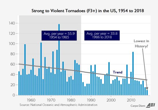
Another important authentic science/meteorology item is that climate change has REDUCED the number of violent tornadoes and tornado deaths.
Re: Re: Severe weather #2 May 7-8, 2024
By metmike - May 10, 2024, 12:11 a.m.
+++++++++++++++++++++
Why is this?
Meteorology 101 tells us what happens when the planet sees the temperature of the highest latitudes (coldest places, especially coldest time of year) warmed up the most. This is beneficial warming! Reduced meridional temperature gradient..........weaker cold fronts and jet streams.
Weather becomes LESS extreme in several realms!
Regardless of these stats, we should always take severe storm outbreaks seriously to minimize risk with actions that are proven to save lives. You can't do anything to stop it but you can go to the safest place.
NEVER be driving around during a tornado warning unless you MUST.(going to work, for instance is good justification-doing grocery shopping , is NOT smart).
Outside of mobiles homes, just go to your safe spot when a violent tornado is approaching. You WILL get a warning that is often as much as 30+ minutes ahead of time with today's Doppler radars that can SEE the tornado, even in its infancy. Most communities have sirens. There are weather radios, tv and internet that give timely warnings.
When it comes to following tornado safety advice there is a huge difference in tornado types. Weak tornadoes will almost never kill anybody in a house, even if you ignore the safety rules.
Violent tornadoes kill the most people of any of the tornadoes and even then, your chances are really good if you go to a safe place. If you know the difference, you can take actions accordingly. One way to tell is by the verbiage from the Tornado Watch. If the Storm Prediction Center states: "This is a particularly dangerous situation" with a tornado watch, then any tornado warning should result in you going to your safe place, especially if that storms approaching have A HISTORY of tornadoes. Also, a violent tornado usually has a powerful signature on the radar which is communicated in the warning verbiage. If you're paying attention/connected then you will know when these rare, highest risks to your life events are about to happen. Even these usually pass without fatalities but almost all fatalities result AFTER these signs and warnings WERE ALREADY PRESENT And we got warnings.
Any tornado from EF2 or stronger is dangerous. Luckily ~86% of tornadoes are EF-0 or EF-1.
Excellent presentation that describes the different types of tornadoes and the damage they cause. Keep in mind that the EF4 and EF5 tornadoes are extremely rare. Less than 1% of tornadoes are this strong.
There is an outside chance that this event coming up could cause an EF2 or stronger tornado In Evansville. That potential will come with a Tornado Watch that uses the verbiage: "This is a particularly dangerous situation"
The EF4 and EF5 tornadoes will usually have the HIGH, level 5 risk earlier that day.
Mike Simon Tornado Damage Intensity; Enhanced Fujita Scale
https://www.youtube.com/watch?v=p-653tSCB68
+++++++++++++++++
![]()
https://www.tornadofacts.net/enhanced-fujita-scale/ef0-tornado.html
The most common and least powerful of all tornadoes are those within the EF0 category. An EF0 tornado is closer in strength to what one might expect out of a straight-line wind during a thunderstorm, or a strong gust on a windy day. With speeds ranging from 65-85 mph, damage is typically minimal, and injuries or deaths are rare with EF0s. However, despite their relatively weak nature, these twisters still have the potential to inflict harm and damage on communities.
++++++++++++++++
https://en.wikipedia.org/wiki/Enhanced_Fujita_scale
| EFU | Unknown | No surveyable damage |
|---|---|---|
| EF0 | 65–85 mph | Light damage |
| EF1 | 86–110 mph | Moderate damage |
| EF2 | 111–135 mph | Considerable damage |
| EF3 | 136–165 mph | Severe damage |
| EF4 | 166–200 mph | Devastating damage |
| EF5 | >200 mph | Incredible damage |
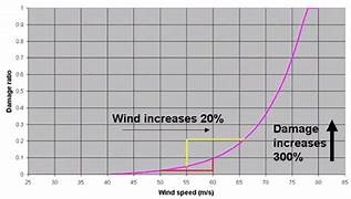
Here's the deal on wind and damage.
As wind increases the damage massively increases on an exponential scale. This applies to ALL wind.
Severe storms and hurricanes and especially tornadoes that have the strongest winds of all, which means the tornadoes with winds over 150 mph have incredible damage.
+++++++++++
+++++++++++++++++++++
A 150 mph wind does 256X more damage than a 75 mph wind. Let's repeat that. A 150 mph wind does 256x more damage than a 75 mph wind!
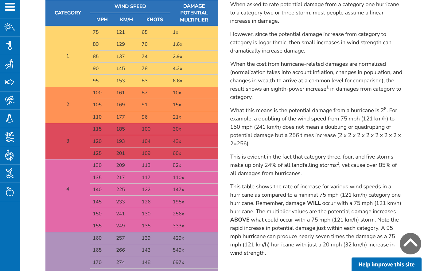
Hurricane Damage Potential
https://www.noaa.gov/jetstream/tc-potential
++++++++++++
Less than 1% of tornadoes are F4 or F5 but they kill 67% of the people!
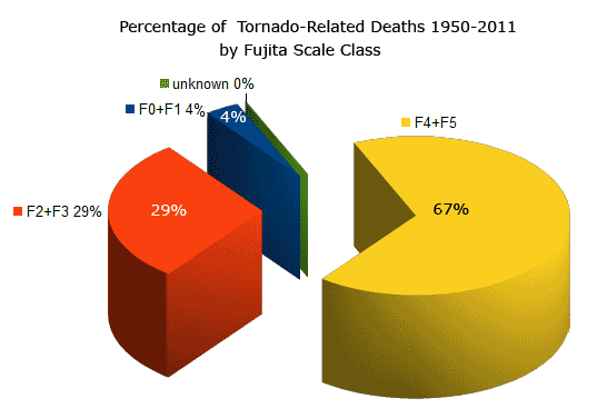
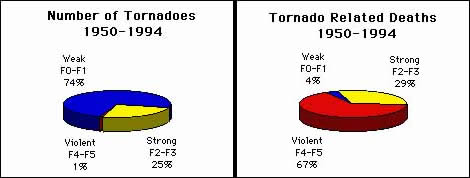
Note that the majority of tornadoes, F0 and F1= 74%(on the old scale) only killed 4% of people.
The F4 and F5's were just 1% but caused 67% of deaths.
Not much change from yesterday's severe weather outlook for the areas with the THREAT of a regional severe weather outlook. This is the day 1 outlook(thru early Saturday Morning)
Please go to the new thread started to track the storm on Friday:
Tracking Severe Weather-3-14-25